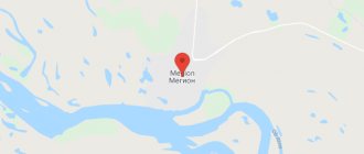
Millerovo on the map of Russia is geographically located in the Rostov region. The Millerovo district is formed around the city, where Millerovo is the center. The city also occupies the position of the center of the Millerovsky urban settlement.
The year the city was founded was 1786. This year the city was a farmstead, founded by decree of Catherine II. Residents of the city participated in the Great Patriotic War, for which the city was later thanked in 1943.
In terms of economic development, the city occupies a leading position in the Rostov region. Millerovo's main activities are manufacturing and agriculture. Among the tourist places, Voloshenskaya Mountain is the most in demand, where paragliding and hang gliding flights are carried out.
Millerovo on the map of Russia: geography, nature and climate
The city is located on the coastal part of the Glubokaya River . Due to its territorial and geographical features and its close location to bodies of water, the city has the coldest climate in the Rostov region.
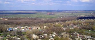
The distance from Rostov-on-Don is 210 km along the highway. The closest densely populated city to Millerovo is Kaminsk-Shakhtinsky.
The climate within the city and the surrounding area is considered cold and with a large amount of precipitation according to the average annual indicator.
In June, Millerovo receives the most precipitation, and March is considered the driest month on average.
Millerovo
(Rostov region)
OKATO code:
60232501
Founded:
1786
City since:
1926 City of district subordination (Millerovsky district, Rostov region)
Center:
Millerovsky district
Telephone code (reference phone)
| 86315***** | 33-50-9 |
Deviation from Moscow time, hours:
0
Geographic latitude:
48°55′
Geographic longitude:
40°24′
Altitude above sea level, meters:
130 Sunrise and sunset times in the city of Millerovo
Routes on the map of Millerovo. Transport infrastructure
In Millerovo there is a railway station (Vokzalnaya str. 1, in the very center of the city), which is part of the North Caucasus Railway. Millerovo station is of particular importance in train traffic - Millerovo station is a junction. The railway tracks passing through Millerovo are of federal importance; they connect the Central Federal District and the North Caucasus. Also from Millerovo station you can take the train to the following destinations:
- Chertkovo.
- Rostov-Glavny.
- Dashing.
Previously, it was possible to get to the city of Lugansk through the Millerovo railway station. As of today, the message has been suspended.
Federal highways pass through the Millerovsky district:
- M4 "Don" - provides transport links with Moscow, Rostov-on-Don and Novorossiysk.
- P272 – serves as a connection with Lugansk and leads to the border with Ukraine.
Small-capacity buses represent the main form of urban transport in Millerovo. On the satellite map of Millerovo you can see existing public transport routes.
Sights of the city of Millerovo
Within the city there are quite a large number of attractions, despite the small territorial size of the city:
- House-Estate M.A. Sholokhov is a house built in the city in tribute to the memory of the great Russian writer who created “Quiet Don”.
- The Museum of Local Lore is a museum dedicated to the history of the city of Millerovo. Initially intended as a museum of military glory, it was later reorganized into the Millerovo Museum of Local Lore.
The addresses of the museums can be found on the map of Millerovo with houses.
On the territory of the city there are a large number of monuments dating back to different periods of the city’s life:
- Bust of A.N. Efimov - the monument was erected in honor of the hero of the Soviet Union, an honorary resident of the city of Millerovo.
- Monument to women collective farmers - erected in honor of home front workers.
- Monument to I.A. Miller - installed in honor of the founder of the city.
- Monument to M.A. Sholokhov - installed in 2007, in honor of the great Russian writer.
- Monument to Tankers - in honor of the tankers who liberated the city during the Great Patriotic War.
- Monument to the Prisoners of DULAG 125 - a monument erected in honor of the prisoners of the DULAG -125 camp.
- Mig-17 - the monument has the shape of an airplane and was erected in honor of the hero of the Soviet Union A.N. Efimova.
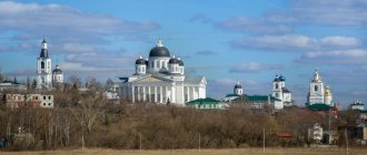
- Church of St. Andrew the Primordial - re-erected on the site of the previous destroyed temple.
- Temple of Panteleimon - particles of the relics of the holy saints of God are kept in the temple.
- Memorial to the Wars - erected in honor of the soldiers who liberated the city in 1943.
The map of Millerovo with streets shows the exact addresses where the mentioned attractions are located.
LiveInternetLiveInternet
Quote from Bakhyt_Svetlana's message
Read in full In your quotation book or community!
The city of Millerovo, Rostov region.
We continue our walk around the Rostov region. Today we are hosted by the city of Millerovo.
| Millerovo is a city, the administrative center of the Millerovsky municipal district of the Rostov region. Located on the Glubokaya River (the left tributary of the Seversky Donets River in the Don basin), in the southeast of the Central Russian Upland, 220 km northeast of the regional center - the city of Rostov-on-Don. Population: 36,499 people (2011). The city of Millerovo is the administrative center of the municipal formation "urban settlement Millerovskoye". |
History of the city of Millerovo
| TO CORRECT |
Hotel "Druzhba" in the city of Millerovo
In the “List of Populated Places of the Land of the Don Army” for 1859, Millerovo is listed as a village owned by the Millers of the Donetsk District along the Glubokaya River, 70 versts from the district village. The village has 27 households and 185 residents of both sexes – 91 males and 94 females. During this period, Millerovo was an unremarkable settlement; there were no public places here. The district administration was located in the village of Kamenskaya (now the city of Kamensk-Shakhtinsky).
"Millerovo, restaurant"
In 1873, according to the “List of Populated Places of the Don Army Region”, Millerovo is listed as the village of Millerov-Glubokinsky near the Glubokinskaya River. The number of courtyards is 49, as well as individual huts that do not constitute courtyards - 4. The number of residents is 323, of which 165 are male, 158 are female. In the village there were 22 plows, 61 horses, 85 pairs of oxen, 240 heads of other cattle, 466 sheep.
"Entertainment center"
The development of the city was facilitated by the construction of the railway. The railway line stretched from Rostov to Voronezh, and then from Voronezh to Moscow. Millerovo station becomes a railway junction. After the advent of the railway, the construction of industrial enterprises began. Most of the factories and factories were built at the beginning of the twentieth century. After some time, Millerovo began to be considered industrial. ″[/img]
"Administration"
According to the “List of Populated Places of the North Caucasus Territory” for 1925, the village of Millerovo was the center of the Millerovo-Glubokinsky village council of the Malchevsko-Polnensky district of the Donetsk district. There were 120 households in the village, in which 645 people lived - 309 men and 336 women. Indicated: 18 wells, 1 school of the 1st level. There was a party organization.
A new stage in the city's development began in 1926, when Millerovo was given city status. Millerovsky district was formed only in 1965. The district, like the city, was considered to be one of the industrial centers of the Rostov region. But the Millerovsky district is famous not only for its industry. There are protected natural monuments of regional significance here. Millerovo during the Great Patriotic War The Great Patriotic War left a deep mark on the history of the city. Millerovo was of strategic importance for the Nazis. The infrastructure has always been developed here. In addition, the invaders were attracted by the convenient geographical location. The Millerovo railway station has been a major railway junction since its inception. On the territory of the city there were food and weapons warehouses, tank repair shops, and not far from the city there was an airfield. The Nazis occupied Millerovo in 1942. The Nazis turned it into a fortified city. The occupiers dug trenches around Millerovo and laid minefields. Barricades were erected on the streets of Millerovo. The German garrison was supplied by rail and dirt roads, the dirt road was located on the side of Voroshilovgrad (now Lugansk, Ukraine). It was almost impossible to get into the city undetected.
"Orbita Park"
In addition to enhanced ground security and complete control of the railway, the Nazis also controlled the airspace until the end of the occupation of the city. December 24, 1942 becomes the date of the beginning of the battle for Millerovo. On this day, the 110th Tank Brigade of the 18th Tank Corps, together with the landing troops, tried to capture the city. However, the fierce resistance of the fascist invaders did not allow the goal to be achieved. 2 Soviet tanks were knocked out. The crew did not survive. On the same day, a huge number of Soviet soldiers died trying to liberate the city. Senior Lieutenant Cesak was able to reach the German airfield in his tank. The tank was unable to get close to the airfield due to an anti-tank ditch dug nearby. However, Cesak managed to shoot down 2 German planes and set fire to the warehouse.
"Hospital"
3 days after the previously described events, the 110th Tank Brigade was given the order to capture the northeastern outskirts of Millerovo. Then the brigade had to advance to the city center as far as possible and gain a foothold in the conquered territory. However, the assigned combat mission could not be completed. The first successes of the liberators appeared only in mid-January 1943. On January 16, Soviet soldiers, despite the resistance of the invaders, were able to break through the blockade ring in the area of the Koshkin mound. The fiercest battles were near the elevator and near the railway station. The liberators continued their movement deeper into the city. Advancement was complicated by snow-covered roads and frosts. But all this did not prevent Soviet troops from completely liberating Millerovo from German troops the very next day. January 17, 1943 is considered the day the city was liberated from fascist invaders.
Church
But residents owe their liberation from occupation not only to the troops. It is impossible not to note the merits of the partisan detachments, the most famous of which was the detachment of senior lieutenant G. Krasilnikov. This group was engaged in sabotage activities in several areas, fighting German and Italian units in the rear. The detachment transmitted valuable information about the enemy’s deployment behind the front line. Sabotage was often carried out among local residents living in the occupied territory. All actions taken by the detachment led to the destruction of more than a hundred German soldiers and officers, several important bridges for the Nazis were destroyed, and a huge amount of enemy equipment was blown up.
There were also isolated cases of heroism. There is a known case when the Germans moved through the Chertkovsky district towards the city. Local collective farmer M. Cherednichenko was forced to be the conductor of a tank column. The column had to pass through the Kalitva River. Cherednichenko directed the tanks to the emergency bridge over the marshy area of Kalitva. The bridge collapsed under the weight of the first tank. The rest of the equipment got stuck in a quagmire. The opponents were forced to abandon their tanks. The city in the modern period In 1989, a new stage in the development of Millerovo began. The city and district were united into one municipal entity with the administrative center in the city of Millerovo. The new municipality has enormous potential for further development and prosperity: favorable geographical and economic position, high agricultural and industrial potential, highly developed transport infrastructure, and availability of natural and labor resources.
hotel "Katyusha"
Temple of John the Warrior
Millerovo says goodbye to you.
Main streets of Millerovo
There are 307 streets in Millerovo, the main of which are:
- Artilleriyskaya Street - on the street there is Kindergarten No. 17 and a branch of the Northern Electric Network.
- Donetskaya Street - the traffic police department of the city of Millerovo is located on the street.
- Kolkhoznaya Street - the street intersects with Promyshlennaya Street and Sovetskaya Street.
- Levanevskogo Street – has an intersection with Turgenevskaya and Elevatornaya streets.
- Rossiyskaya Street is the main street of the city of Millerovo. The street carries about 50% of the city's total vehicle traffic and has an intersection with 18 streets.