Ekaterinburg
- Population: 1,483,119 people (2019)
- Founded in 1723 1924-1991 - Sverdlovsk
The administrative, scientific, educational, cultural center of the Ural region, has the status of the center of the federal Ural District. Here is the Presidium of the Ural Branch of the Russian Academy of Sciences, the headquarters of the Central Military District, 35 ter. federal authorities, the city is considered the “capital of the Urals”.
Ekaterinburg is the 4th most populous city in the Russian Federation. It is a transport and logistics hub on the Trans-Siberian Railway. It is a large industrial center (metallurgy, heavy engineering and instrument making, military-industrial complex, food and light industry, printing industry, optical-mechanical industry).
The city is located on the eastern slopes of the Middle Urals mountains, on the banks of the Iset River. There are 4 natural lakes within the city limits.
It should be noted that the geographical location of the city is extremely advantageous and has had a positive impact on its development. The mountains of the Middle Urals are of low height. At the same time, the main transport routes to Siberia from Central Russia (the Great Siberian Highway, now the Trans-Siberian Railway) were built through Yekaterinburg. As a result, the city was formed as an important strategic center of Russia; it still provides a connection between the Asian and European parts of the country.
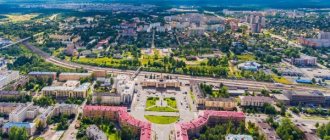
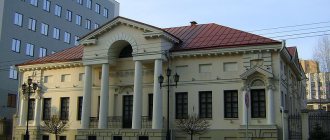
Magnitogorsk is a cultural and business center
The central position of the economy of Magnitogorsk is still occupied by the production of metallurgical products. A large number of enterprises engaged in the industrial sector provide significant (multi-billion dollar) turnover. This at the same time has a bad effect on the ecology of the city. Magnitogorsk is comparable to megacities where there is an unfavorable environmental situation due to the concentration of harmful substances such as iron oxide, nitrogen dioxide, formaldehyde, carbon monoxide and others.
Now it still ranks at the top of the list of environmentally unfavorable cities. Students flock here to study at a state university. The main specialties are technical. For cultural leisure, Magnitogorsk offers theaters, circuses, museums, libraries and cinemas. As in Chelyabinsk, in terms of sports, Magnitogorsk residents prefer hockey. Magnitogorsk has always served the needs of the front, as evidenced by its monuments. For example, the famous monument “Rear to Front” represents two warriors. Many monuments are dedicated to workers, military equipment, and various social phenomena. There is a monument to the first steam locomotive, parents, teacher, janitor, plumber and even a blast furnace operator.
Chelyabinsk
- Population: 1,200,719 people (2019)
- Founded in 1736. Named: Tankograd, Chelyaba, Che.
Large city of the Russian Federation, administrative center. Major transport hub (Trans-Siberian Railway, highways and railways). Airport "Chelyabinsk" (formerly "Balandino"). Large industrial center: metallurgy, instrument making, mechanical engineering and metalworking, food and light industry.
Chelyabinsk is located on the eastern slopes of the Ural Mountains, on the Miass River. Height 200-250 m above sea level. Geological location: Ural (granite) - western part, Western Siberia (sedimentary rocks) - eastern part, while the city is located on the border of Siberia and the Urals. The “Siberian” and “Ural” banks of the Miass River are connected by the Leningradsky Bridge - this is “a bridge from the Urals to Siberia”. The Meridian highway runs along the border strictly between Siberia and the Urals from Lenin Avenue to Mekhanicheskaya Street: drive along Lenin Avenue under viaduct a. "Meridian" is the most popular among city residents.
The city is located on the Miass River, the city is washed by 3 lakes: Smolino, Pervoye, Sineglazovo and Shershnevskoye Reservoir. Many small rivers are channeled through collectors and pipes underground. The relief in the city in the west is slightly hilly, it gradually decreases to the east, “cut” by the valley of the Miass River and hollows with swamps and lakes. The banks of the river are covered in places with bushes and forest.
Significant event:
A meteorite fell on Chelyabinsk - the fall occurred on the morning of 02/15/2013. In the vicinity of Chelyabinsk, a meteorite body exploded at an altitude of 15-25 km. 1613 people were injured; the fall of this meteorite has no analogues in the world’s documented history.
Ufa
- Population: 1,124,226 people (2019)
- Founded 1574
The capital of Bashkortostan, the largest oil refining center in Russia, an important transport hub. Multi-faith religious center.
The millionaire city of Ufa is the most spacious in the Russian Federation; in 2010, there were 698 m² of urban territory per resident.
In 2015, Ufa is scheduled to host the BRICS and Shanghai Cooperation Organization summits.
Ufa took 2nd place in terms of living comfort according to the integral rating of the 100 largest cities in Russia in 2012; and 2nd place according to the Forbes rating “The best cities in Russia for business - 2012”.
The city lies on the Pribelsky ridge-undulating plain, 100 km west of the ridges of the Southern Urals, on the banks of the river. Belaya, with the river flowing into it. Dema and Ufa. Mainly located on the Ufimsky Peninsula, between the Belaya and Ufa rivers. The city is 53 km long - from north to south, 28 km - from west to east.
Ufa is the 3rd longest city in the Russian Federation (Sochi and Volgograd).
Permian
- Population: 1,053,938 people (2019)
- Founded in 1723, 1940-1957 - Molotov.
Millionaire city. Perm is only 1.5° south of St. Petersburg, which is considered the northernmost city with a population of more than 1 million people.
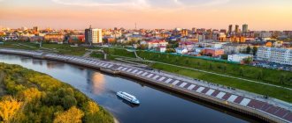
Perm is located in the foothills of the Urals in the Eastern European part of the Russian Federation. It is the administrative center of the region, an urban district, a port on the Kama River, and a transport hub of the Trans-Siberian Railway. It is a diversified large industrial, logistics, cultural and scientific center of the Urals.
In 1916, a university was opened in Perm - the first in the Urals.
The Kama plays the role of a city-forming axis: Perm stretches along it for 70 km. Thanks to this river, Perm is connected by waterways with 5 European seas: the Baltic, Caspian, Black, White and Azov.
The right bank of the Kama is lower than the left, which is dissected by ravines and ravines. A characteristic feature of Perm is the many small rivers within the city; they flow through the city’s numerous ravines.
Orenburg
- Population: 568,733 people. (2019)
- Founded 1743
A city in the southern Urals, the administrative center of the region. Orenburg has a population of 570.3 thousand people, 2012. In terms of population, it ranks 28th in the Russian Federation.
The city is located on the Ural (Yaik) River, near the confluence of the Sakmara River. Pedestrian bridge over the Ural River
Orenburg is located entirely in Europe. The historical symbolic sign of the border between Asia and Europe stands on the pedestrian bridge over the river. Ural. But this border has not been recognized since 1959 by the International Geographical Union; then the opinion of USSR scientists about the Europe-Asia border along the Mugodzhary, Ural Mountains and rivers was taken into account. Emba. By this definition, p. The Urals are a natural water border between Asia and Europe only in its upper reaches across the territory of Russia. Then the geographical border of Europe and Asia comes from the river. The Urals go south along the Or River from Orsk, along the Mugodzhary ridge and the river. Emba before it flows into the Caspian Sea. At the same time, R.
The Ural is a 100% internal European river, only in its Russian upper reaches the left bank is classified as Asia. And the city of Orenburg, with this border, can be considered a completely European city.
Tourist potential of the Urals.
The Ural region is actively developing as a tourist center; there is always a large flow of tourists and travelers from all over the world.
Attractions
The Urals are a treasure trove of interesting places that attract tourists from all over the world, because there are few places where you can find so many historical monuments, natural healing springs and ancient buildings.
The most frequently visited places in the Urals:
- The Nevyansk Tower is attractive to tourists because prisoners lived here, some were even buried right within the walls. On one of the floors there is a strange room - a word spoken quietly in one part of the room is clearly heard in another corner, but not heard in the middle of the room.
- Ganina Yama – the murdered family of Nicholas II was thrown here in 1918. Now there is a monastery here; pilgrims and history buffs are frequent visitors.
- Nizhnyaya Sinyachikha – a museum, the exhibits of which are ancient houses from the 17th to 19th centuries, for example, there are chapels and peasant dugouts.
- Verkhoturye is the spiritual abode of Russia. In Verkhoturye there are 2 ancient monasteries, several ancient temples of very large area.
- Arkaim is an ancient settlement in the Southern Urals, it is a very mysterious place, because until now no one knows for certain what happened in this place in the past. There are almost constant excavations going on here.
- Hot springs are natural waters in Tyumen, the temperature of which is 40-45 degrees, and the composition of this water is considered medicinal. You can especially feel the beauty of this source in winter, when the temperature difference is very noticeable.
- Kungur Cave is an ice cave in the Perm region. In winter it is filled with stalactites and stalagmites, and in summer any sounds echo in the cave.
- Oleniy Ruchi is a park in the Sverdlovsk region. Once upon a time, drawings of primitive people were found here, the most famous of them is a deer, which is now a symbol of the park. There are many caves and rocks here, so the place is in demand among tourists.
- The border between Europe and Asia is a natural border in the east of the Ural Range, where the obelisk is installed, against which all tourists take photographs. You can have one foot in Asia and the other in Europe.
Interesting places
The Ural region is rich not only in attractions, but also in mysterious places that not many people visit.
The strangest of them:
- The “Stone Gate” rock is a natural stone wall 20 m high, in the middle of the rock there is a 10 m hole, the rock consists of limestone, which is clearly visible in the sections. Some researchers believe that the rock is formed from the remains of a volcano, and local legend says that there used to be a seabed in place of the rock.
- The Zyuratkul fountain is an interesting water source on the territory of the city of Satka in the National Nature Reserve. The source appeared by chance in 1976, when local geologists, searching for ore, came across a source that gushed up 7 m. In winter, the fountain freezes in the form of a pillar.
- Dyatlov Pass - perhaps the most mysterious and frightening place in the Urals, it is located in the Northern Urals. It has had its name since 1959 because of the tragic incident that happened to Igor Dyatlov’s team of tourists, consisting of 9 people.
- The Man-Pupu-Ner plateau is a forgotten place of the Urals, here there are stone blocks 40 m high. These stones were formed as a result of weathering. Once upon a time there were mountains that collapsed over time, and all that remained were these stone pillars. Many tourists note the extraordinary lightness and peace next to these rocks.
- Lake Shaitanka is a mysterious place, which is famous for its bottomlessness, only the explored depth is 200 m. Local residents say that a certain monster lives in these waters and UFOs have been observed here more than once. And sometimes the lake begins to overflow, the water floods nearby areas and the air becomes foul.
Cultural tourism
In recent years, cultural tourism in the Urals has been developing very successfully; people from all over the world come here for interesting emotions and adrenaline.
The most popular places among tourists are:
- Aquilon husky center is an active holiday destination, the main entertainment here is dog sledding and horse-drawn sleigh rides, and there is an ATV. On the territory of the center there is a Russian hut with ancient furnishings inside, where you can drink tea from a samovar and warm up by the stove, you can attend a master class on blacksmithing;
- museum-settlement Gardarika. In this place you can learn everything about ancient Rus'; historian guides talk about what is not written in textbooks. Here they teach you how to shoot a bow, tug of war, ancient fighting techniques, and show you how to make a fire without matches;
- excursion around Yekaterinburg - for those who like long walks. Guides talk about ancient houses that have stood since the very foundation of the city, about local attractions, urban legends, accompanying the story with historical photographs.
Active recreation in the Urals
The Urals are a special place on the world map of Russia, where there is beautiful nature that is in constant transformation. Vacationing here is in many ways more pleasant than abroad. In the summer you can take part in water rafting or hiking in the mountains or just within the city, hiking with tents and backpacks.
All types of outdoor activities are actively practiced in the Urals; you can endlessly enjoy the beautiful landscapes, watch sunsets and sunrises on the slopes of the mountains. For those who prefer fishing, we can recommend the Chusovaya River, and for those who like hiking, natural parks and canyons. Mount Azov is also suitable for active recreation; there are many legends about this place.
Mysticism literally haunts the Urals, for example, the Perm Triangle is a place where ufologists regularly find evidence of the presence of UFOs; white balls of unknown origin often appear in the sky above this territory.
In the Urals, such types of active recreation as mountain hiking and rock climbing are common, and in winter, ski resorts are organized on the territory of these same mountains. And on Mount Ieremel the snow does not melt until summer, so lovers of alpine skiing will find entertainment for themselves even in summer.
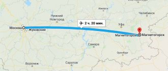
Magnitogorsk
- Population: 416,521 people (January 1, 2022)
- Founded 1929
The city of the Chelyabinsk region of the Russian Federation, one of the largest centers of ferrous metallurgy in the world.
Magnitogorsk is 420 km away from Chelyabinsk by rail, 308 km by road, and 321.4 km from station to station by highway.
The territory of Magnitogorsk is 392.35 km², length 27 km from south to north, 22 km from west to east, 310 m altitude.
The western border of Magnitogorsk is the administrative border of the Chelyabinsk region and Bashkortostan.
Magnitogorsk is located at the foot of the Magnitnaya Mountain, on the eastern slopes of the Southern Urals, on 2 banks of the river. Ural (right coast of Europe, left coast of Asia). The city lies on the historical territory of Bashkortostan. It is the 25th city in the Russian Federation by area and 42nd by population.
Interesting facts about the Urals
Some interesting, but little-known facts about the Urals:
- The Ural Mountains have a length of more than 2 thousand km.
- At their narrowest point, the Ural Mountains are approximately 40 km wide, and at their widest point, about 150 km wide.
- In geographical terms, the Ural Mountains belong neither to Europe nor to Asia, but act as a natural barrier and border between these parts of the world.
- Ancient geologists believed that there was nothing beyond the border of the Ural Mountains, and that the mountains themselves were the border of the world, the edge of the world.
- The oldest mountain on Earth is Mount Karandash, it is part of the Ural ridge, and its age is at least 4.2 billion years (the age of planet Earth is 4.6 billion years).
- The Ural Mountains pass through all climate zones, excluding deserts and semi-deserts.
- From malachite mined in the Urals, bowls were cast in the Hermitage in St. Petersburg and the interior of the altar of the Church of the Savior on Spilled Blood was decorated.
- In Bashkiria there are ancient coral reefs (Sterlitamak shikhans), which formed in the Perm Sea about 230 million years ago, and they look like cone-shaped hills.
- It was in honor of the Ural Mountains that a motorcycle, a guitar and a truck were named.
- Sugomakskaya Cave is the only marble cave in the Urals, its length is 123 m.
The Urals are not the only rich region located on the map of Russia, but the fact is undeniable that few regions can compare with it in terms of the number of picturesque places and mineral resources, majestic mountain ranges and diversity of flora and fauna.
Author: Ekaterina Pestova
Article design: Oleg Lozinsky
Nizhny Tagil
- Population: 352,135 people. (2019)
- Founded 1722
Nizhny Tagil (mans., a lot of water) is a city in the Sverdlovsk region of the Russian Federation, the center of the Gornozavodsk administrative district, the administrative center of the Gornouralsk urban district and the “city of Nizhny Tagil”. Population 361.33 thousand people, 2011, ranks 2nd in population in the Sverdlovsk region. The area of Nizhny Tagil is 298.47 km², and the area of the urban district as of April 1, 2008 is 4108 km².
In terms of the volume of goods from its own manufacturing production, Nizhny Tagil in the Sverdlovsk region ranks first, ahead of even Yekaterinburg. In 2007, the volume of these goods was shipped there for a total amount of 131.8 billion rubles.
The city is located on the eastern slopes of the Ural Mountains, 20-25 km from the border of Asia and Europe, 200 m above sea level.
Nizhny Tagil is the older brother of Ekaterinburg, since it was founded a year earlier. However, it did not have the chance to become the capital of the Urals. In recent years, Tagil's status has grown greatly. Since in Russia the largest arms exhibition “Uralexpoarms” takes place in the immediate vicinity of Nizhny Tagil, at the world-famous “Staratel” training ground. Military attaches, generals, ministers and other high-ranking customers and arms buyers from various countries come to Nizhny Tagil.
What else are shown to dear guests, besides demonstration exercises and shooting? Since the reputation and name of the city are provided by its attractions.
Artist Sergei Bryukhanov hosts many official foreign delegations in his studio. His abstract, complex compositions made foreigners freeze with their mouths open in surprise more than once. There is nothing to marvel at. There is a whole direction, the Tagil art school. And in the past, Nizhny Tagil gained unfading fame for its varnish painting on metal - the famous Nizhny Tagil trays. It was them, and not nesting dolls, that traveling foreigners used to take home.
Region meaning
It is known that the Ural region is one of the most important centers for the development of many industries. The resources that this territory possesses can serve as a good element for the scientific and technological progress of the entire country. Rich mineral deposits, competitiveness of production, scientific and technical potential can be the basis for the successful development of the Urals.
But the obstacle to this is that now most production facilities are passing into the hands of entrepreneurs. Now the potential of the Urals is no longer aimed at scientific progress, but at working for people. For example, in the Urals in recent years, agriculture, and especially farming, has been intensively restored.
Private entrepreneurship is developing well, providing a large number of people with jobs in the best and most promising enterprises. It is private entrepreneurs who are able to boost the economy of the region, because they have a personal interest in success.
Mining in the mountains is the basis for the development of ferrous and non-ferrous metallurgy, and metallurgy and mechanical engineering themselves are the main areas in terms of the number of products produced.
The Urals also copes well with service production, mining of coal, electricity, and consumer goods. The Urals are the leader in the supply of titanium, magnesium and aluminum. The Urals on the map of Russia are in a very favorable location relative to oil fields. Oil production is carried out mainly in the Orenburg and Perm regions.
Kurgan (city)
- Population: 315,311 people (2019)
- Founded in 1679 Tsarevo Settlement - until 1738; Kurganskaya Sloboda - until 1782.
Kurgan is a large city in the Russian Federation, the administrative center of the region. Located in the Urals Federal District (Ural Federal District), in the Southern Urals and Trans-Urals, along the banks of the river. Tobol (mainly on the left bank).
Population - 327.9 thousand people, 2012. Area 393 km²
This is an important scientific, cultural and economic center of the Ural Federal District, a major transport hub. Industrial center (military-industrial complex, medium-sized mechanical engineering, light and food, chemical, industry). Kurgan is widely known, as the Russian Scientific Research Institute is located here. Ilizarov. The city also produces the famous KAVZ buses, BMP-3 infantry fighting vehicles, and medicines.
The mound is located in fact in the center of Eurasia, 75 m above sea level. The city lies on the West Siberian Plain. It should be noted that the geographical location of the city is extremely advantageous and has had a positive effect on the development of the city. The main transport routes from the Center of Russia to Siberia (the Baikal federal highway, the Trans-Siberian Railway) run through Kurgan, providing communication between the Asian and European parts of the country.
Which regions of Russia are included in Siberia?
Siberia is divided into Western: Tyumen (with the Khanty-Mansi and Yamalo-Nenets Autonomous Okrugs), Kurgan, Novosibirsk, Omsk, Tomsk and Kemerovo regions, Altai Territory, Altai Republic and Eastern: Krasnoyarsk and Transbaikal Territories, Irkutsk Region, the Republics of Khakassia, Tuva , Buryatia and Yakutia.
Interesting materials:
How to save photos from iPhone to hard drive? How to save photos from iPhone to the cloud? How to save GIF from Telegrams to iPhone? How to save a GIF from a telegram to an iPhone? How to save a GIF from a contact to iPhone? How to save a GIF on iPhone? How to save a GIF from Telegram to iPhone? How to save a GIF to iPhone from VK? How to save a GIF to iPhone from a contact? How to save contacts when changing iPhone?
Sterlitamak
- Population: 278,127 people. (January 1, 2022)
- Founded 1766
A city with republican subordination in Bashkortostan of the Russian Federation, a large regional center, a former administrative regional center. The former capital of the Bashkir Autonomous Soviet Socialist Republic, administrative district center, while Sterlitamak is part of an independent municipal formation of Bashkortostan - the urban district of the city of Sterlitamak. Population 274.38 thousand people, 2012. The second largest population in Bashkortostan after the capital of the republic - Ufa.
The city lies on the left bank of the river. Belaya (Kama tributary).
It is a major center of mechanical engineering and chemical industry.
Sterlitamak is the center of the polycentric agglomeration of Southern Bashkortostan, which has powerful production potential.
Sterlitamak is located in the European part of the Russian Federation, just south of Ufa, 121 km. To the east of the city (about 50 km) are the Ural Mountains, and to the west is the East European Plain. Within Sterlitamak (the valley of the Belaya River) lie the shikhans (Kushtau, Yurak-tau, Shakhtau, Tratau) - these are unique geological natural monuments. Near Mount Kushtau there are children's health camps, holiday homes and ski resorts. Ufa International Airport is located about 100 km from Sterlitamak.
Initially, the city was built between the Sterlya and Ashkadar rivers (historical center, Old Town). Then Sterlitamak was built up mainly to the north and west.
The largest nearby cities are Salavat (26 km to the south) and Ishimbay (21 km to the southeast).
The river flows in the center of the city. Sterlya, it flows into Ashkadar, on the eastern part. Five road bridges and one railway bridge were built across the river within Sterlitamak. In the southeast, Ashkadar is separated by the Zaashkadarye district from the main part of the city. The river is adjacent to the east. Belaya, this is the border between the Ishimbay and Sterlitamak regions of the republic. In the Mashzavod area, in the south, Sterlitamak borders the river. Olkhovka (tributary of the Ashkadar).
Map
| Kamensk-Uralsky: maps |
Kamensk-Uralsky: photo from space (Google Maps) Kamensk-Uralsky: photo from space (Microsoft Virtual Earth)
| Kamensk-Uralsky. Nearest cities. Distances in km. on the map (in brackets along roads) + direction. Using the hyperlink in the distance , you can get the route (information courtesy of the AutoTransInfo website) | |||
| 1 | Bogdanovich | 41 (103) | WITH |
| 2 | Kataysk | 42 (46) | IN |
| 3 | Beloyarsky | 48 (63) | NW |
| 4 | Sukhoi Log | 56 (119) | WITH |
| 5 | Zarechny | 57 (71) | NW |
| 6 | Elansky | 59 () | NE |
| 7 | Dalmatovo | 63 (69) | IN |
| 8 | Verkhneye Dubrovo | 64 () | NW |
| 9 | Bobrovsky | 64 (108) | NW |
| 10 | Sysert | 68 (130) | Z |
| 11 | Kamyshlov | 68 (144) | NE |
| 12 | Asbestos | 70 (87) | WITH |
| 13 | Aramil | 73 (124) | NW |
| 14 | Reftinsky | 74 (109) | WITH |
| 15 | Source | 75 () | NW |
| 16 | Big Source | 77 () | NW |
| 17 | Snezhinsk | 81 (119) | SW |
| 18 | Kunashak (Chelyabinsk region) | 82 (100) | YU |
| 19 | Malysheva | 83 (102) | WITH |
| 20 | Berezovsky | 86 (126) | NW |
| 21 | Mountain Shield | 91 () | Z |
| 22 | Ekaterinburg | 93 (110) | NW |
| 23 | Kasli | 93 (123) | SW |
| 24 | Monetary | 94 (147) | NW |
| 25 | Bulanash | 95 (235) | WITH |
| 26 | Pyshma | 100 (182) | NE |
| 27 | Upper Pyshma | 101 (133) | NW |
| 28 | Artyomovsky | 103 (227) | WITH |
| 29 | Ozyorsk | 105 (141) | SW |
| 30 | Polevskoy | 106 (166) | Z |
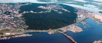
a brief description of
Located on the southeastern slope of the Middle Urals, at the confluence of the river. Kamenka in the river Iset (Ob basin), 100 km southeast of Yekaterinburg. Large railway node
Territory (sq. km): 142
Information about the city of Kamensk-Uralsky on the Russian Wikipedia site
Historical sketch
Known as the Zhelezinsky settlement, which in 1682 was assigned to the Dalmatovsky monastery.
In 1700, by decree of Peter I, the Kamensky Iron Foundry was founded (launched in 1701) - one of the oldest mining plants in Russia, producing cannons, mortars, cannonballs, etc. Name after the river. Kamenka.
At the end of the 19th century. center for trade in agricultural products.
During the pre-war five-year plans, it became a site for the construction of large industrial enterprises.
Workers' settlement since April 5, 1926. Since 1935, the city of Kamensk, since 1940, Kamensk-Uralsky.
It actively developed during the Great Patriotic War of 1941-45.
Municipal indicators
| Index | 1999 | 2001 | 2003 | 2005 |
| Demography | ||||
| Number of births, per 1000 population | 6.9 | 8.3 | 9.9 | 10.2 |
| Number of deaths, per 1000 population | 15.4 | 16.5 | 17.6 | 16.6 |
| Natural increase (decrease), per 1000 population | -8.5 | -8.2 | -7.7 | -6.4 |
| Standard of living of the population and social sphere | ||||
| Average monthly nominal accrued wages, rub. | 1381 | 3567 | 5862 | 8460 |
| Average housing area per inhabitant (at the end of the year), sq.m. | 19.4 | 19.7 | 20.1 | 20.3 |
| Number of preschool institutions, pcs. | 63 | 57 | 55 | 57 |
| Number of children in preschool institutions, thousand people | 6.6 | 6.3 | 6.5 | 6.9 |
| Enrollment of children in preschool educational institutions (at the end of the year), as a percentage of the number of children of the corresponding age, % | 76.8 | 74.2 | ||
| Number of daytime educational institutions (at the beginning of the school year), pcs. | 41 | 40 | 41 | 39 |
| Number of students in daytime educational institutions, thousand people | 25.2 | 22.3 | 19 | 16.1 |
| Number of doctors, people. | 668 | 645 | 675 | 631 |
| Number of nursing staff, people. | 2236 | 2188 | 2218 | 2123 |
| Number of hospital institutions, pcs. | 14 | 11 | 10 | 8 |
| Number of hospital beds, thousand units | 2.1 | 2 | 2 | 2 |
| Number of medical outpatient clinics, pcs. | 29 | 27 | 22 | 24 |
| Capacity of medical outpatient clinics, visits per shift, thousand units. | 8.6 | 8.7 | 6.5 | 6.4 |
| Number of registered crimes, pcs. | 6172 | 6116 | 4324 | 6285 |
| Persons who committed crimes were identified, persons. | 3039 | 2833 | 1665 | 1756 |
| Economy, industry | ||||
| Number of enterprises and organizations (at the end of the year), pcs. | 2153 | 2353 | 2406 | 2656 |
| Number of operating enterprises by type of activity: mining (at the end of the year), pcs. | 0 | |||
| Number of operating enterprises by type of activity: manufacturing (at the end of the year), pcs. | 86 | |||
| Number of operating enterprises by type of activity production and distribution of electricity, gas and water (at the end of the year), pcs. | 30 | |||
| Volume of shipped goods of own production by type of mining (in actual prices), million rubles. | 0 | |||
| Volume of shipped goods of own production by type of manufacturing (in actual prices), million rubles. | 64833 | |||
| Volume of shipped goods of own production by type of production and distribution of electricity, gas and water (in actual current prices), million rubles. | 2905.1 | |||
| Construction | ||||
| Volume of work performed by type of activity “Construction” (until 2004 - volume of work performed under construction contracts), million rubles. | 161.5 | 306.2 | 339.7 | 482 |
| Commissioning of residential buildings, thousand sq.m. of total area | 11 | 1.8 | 10.2 | 25.9 |
| Commissioning of residential buildings, apartments | 159 | 16 | 135 | 293 |
| Commissioning of preschool institutions, places | 0 | 0 | 0 | 0 |
| Commissioning of educational institutions, places | 0 | 0 | 0 | 0 |
| Commissioning of hospital facilities, beds | 0 | 0 | 0 | 0 |
| Commissioning of outpatient clinics, visits per shift | 0 | 0 | 0 | 0 |
| Transport | ||||
| Number of bus routes (in intracity traffic), pcs. | 21 | 22 | 29 | 27 |
| Number of tram routes, pcs. | 0 | |||
| Number of trolleybus routes, pcs. | 5 | 4 | ||
| Length of operational trolleybus lines (at the end of the year), km | 21.7 | 21.7 | ||
| Number of passengers transported by buses per year (in intracity traffic), million people. | 57.9 | 64.9 | 64.1 | 56.1 |
| Number of passengers transported by trams per year, million people. | 0 | |||
| Number of passengers transported by trolleybuses per year, million people. | 50 | 50.5 | 51.6 | |
| Connection | ||||
| Number of residential telephone sets of the city public telephone network, thousand units. | 21.1 | 25 | 26.9 | 36.9 |
| Number of payphones of the city telephone network (including universal ones), pcs. | 221 | 221 | ||
| Trade and services to the population | ||||
| Retail trade turnover (in actual prices), million rubles. | 1271 | 3378 | 5550 | 8178.1 |
| Retail trade turnover (in actual prices), per capita, rub. | 6590 | 17760 | 30060 | 44325.7 |
| Index of physical volume of retail trade turnover, % compared to the previous year | 103.8 | 110.3 | ||
| Public catering turnover (in actual prices), million rubles. | 77.9 | 259.4 | 444.6 | 632.4 |
| Index of physical volume of public catering turnover, % compared to the previous year | 117.1 | 112.1 | ||
| Number of stores, pavilions (at the end of the year), pcs. | 9 | 4 | ||
| Sales area of shops, pavilions (at the end of the year), sq.m. | 806 | 724 | ||
| Volume of paid services to the population (in actual prices), million rubles. | 284 | 659.2 | 1043.8 | 1670.1 |
| Volume of paid services to the population (in actual prices), per capita, rub. | 1472 | 3493 | 5585 | 9075.1 |
| Volume of household services to the population (in actual prices), million rubles. | 14.7 | 33.6 | 38.8 | 65.7 |
| Volume of household services to the population (in actual prices), per capita, rub. | 76 | 178 | 207.7 | 356.5 |
| Investments | ||||
| Investments in fixed assets (in actual prices), million rubles. | 363.7 | 1132 | 2813.7 | 2104.4 |
| Share of investments in fixed assets financed from budgetary funds in the total volume of investments, % | 2.2 | 2.8 | 5.9 | 6.8 |
Data sources:
- Regions of Russia. Main characteristics of the constituent entities of the Russian Federation: statistical collection. Goskomstat of Russia. - M:, 2003.
- Regions of Russia. Volume 1. Statistical collection. Goskomstat of Russia. - M:, 2001. p. 416
- Regions of Russia. Basic socio-economic indicators of cities. Statistical collection. Rosstat. - M:, 2005. p. 269
- Transport in Russia: Statistical collection. Goskomstat. - M:, 2003. pp. 112, 122
- Transport in Russia: Statistical collection. Rosstat. - M:, 2005. pp. 119, 129
- Regions of Russia. Basic socio-economic indicators of cities. 2006. Statistical collection. Rosstat. - M:, 2006. p. 265
Economy
Kamensk-Uralsky is a large industrial center with a predominance of ferrous and non-ferrous metallurgy, mechanical engineering and the food industry.
Leading enterprises: plants - Sinarsky Pipe, Ural Aluminum, Metallurgical, Foundry, for processing non-ferrous metals.
Sewing and shoe factories. Radio engineering and electrical engineering enterprises, production of building materials.
Krasnogorsk Thermal Power Plant.
Potatoes and vegetables are grown in the Kamensky district. Dairy farming.
Main enterprises
PIPE PRODUCTION
JSC Sinarsky Pipe Plant
623401, Sverdlovsk region, Kamensk-Uralsky, Zavodskoy proezd, 1
Offers:
steel pipes, cast iron pipes, titanium alloy pipes, tape, cast iron and steel castings
NON-FERROUS METALLURGY
OJSC "Kamensk-Uralsky Kamensk-Uralsky Metallurgical Plant"
623405, Sverdlovsk region, Kamensk-Uralsky, st.
Zavodskaya, 5 Offers:
ingots, flat rolled aluminum alloys, extruded products, welded pipes made of aluminum alloys and steel, light alloy drill pipes, rods, wire
Ural aluminum
623406, Sverdlovsk region, Kamensk-Uralsky, st.
Zavodskaya, 4 Offers:
steel, electric steel, primary aluminum, alumina, silicon, steel castings, cast iron, grinding balls
Culture, science, education
General technical faculty of the Ural Technical University.
Drama Theater. Museum of Local Lore.
Universities of the city
Kamensk-Uralsky branch of the Ural Institute of Economics, Management and Law
623408, Sverdlovsk region, Kamensk-Uralsky, st. Belinskogo, 1
Polytechnic Institute of the Ural State Technical University - UPI named after. the first President of Russia B.N. Yeltsin, Kamensk-Uralsk
623400, Sverdlovsk region, Kamensk-Uralsky, st. Lenina, 34 WWW: https://upi.kamensktel.ru/
Ural State Economic University (Kamensk-Ural branch)
623408, Sverdlovsk region, Kamensk-Uralsky, Aluminum street, 37-a WWW: https://www.kufeu.ru/
Museums, galleries, exhibition halls
Kamensk-Ural Museum of Local Lore named after.
AND I. Styazhkina 623409, Sverdlovsk region, Kamensk-Uralsky, pl. October 25 Phone(s): (3439) 324-461 (3439) 323-472 (ex.bureau) Museum of the History of Rural Culture 623462, Sverdlovsk region, Kamensky district, urban-type settlement Martyush, st. Lenina, 11 Phone(s): (34378) 7-4425
Architecture, sights
The city's territory extends from northwest to southeast for more than 20 km. The old part of Kamensk-Uralsk is located between the Iset and Kamenka rivers.
Office building of the Kamensky State Iron Foundry (19th century, architect M.P. Malakhov).
The modern city is distinguished by the disunity of residential areas located near industrial enterprises and representing separate villages surrounding the old city.
There are natural monuments in the area: rocks - Bogatyryok (on the left bank of the Kamenka River, within the city), Stone Gates (right bank of the Iset River), Three Caves (left bank of the Iset River), etc.
| Population by year (thousands of inhabitants) | |||||||
| 1926 | 5 | 1976 | 182 | 2001 | 189.2 | 2013 | 172.1 |
| 1931 | 8.7 | 1979 | 187.4 | 2003 | 186.2 | 2014 | 171.5 |
| 1939 | 50.9 | 1982 | 193 | 2005 | 183.3 | 2015 | 170.9 |
| 1956 | 122 | 1986 | 202 | 2006 | 182.5 | 2016 | 170.2 |
| 1959 | 141.0 | 1989 | 207.8 | 2007 | 181.6 | 2017 | 169.9 |
| 1962 | 152 | 1992 | 208.7 | 2008 | 180.9 | 2018 | 169.0 |
| 1967 | 161 | 1996 | 195 | 2010 | 179.1 | 2019 | 167.4 |
| 1970 | 169.3 | 1998 | 193.0 | 2011 | 174.7 | 2020 | 166.1 |
| 1973 | 175 | 2000 | 190.6 | 2012 | 173.1 | 2021 | 164.0 |