This term has other meanings, see Komsomolsk.
| City | |
| Komsomolsk | |
| 57°02′00″ n. w. 40°23′00″ E. d.HGYAO | |
| A country | Russia |
| Subject of the federation | Ivanovo region |
| Municipal district | Komsomol |
| urban settlement | Komsomolskoe |
| Chapter | Novikova Irina Gennadievna |
| History and geography | |
| Based | in 1930 |
| City with | 1950 |
| Square |
|
| Center height | 145 m |
| Timezone | UTC+3:00 |
| Population | |
| Population | ↘7978[1] people (2021) |
| Katoykonim | Komsomol members, Komsomol member, Komsomol member |
| Digital IDs | |
| Telephone code | +7 49352 |
| Postcode | 155150 |
| OKATO code | 24213501000 |
| OKTMO code | 24613101001 |
| Komsomolsk Moscow Ivanovo Komsomolsk | |
| Media files on Wikimedia Commons | |
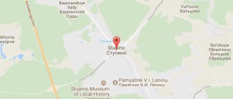
Komsomolskoe urban settlement on the map of Komsomolsky district
Komsomolsk
- a city (since August 28, 1950[2]) in Russia, the administrative center of the Komsomolsky district of the Ivanovo region. Included in the Komsomolskoye urban settlement.
Population
According to 2022 data, the number of residents in Komsomolsk is 8058 people.
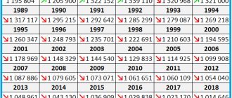
| Population | |||||
| 1859[3] | 1905[4] | 1939[5] | 1959[6] | 1970[7] | 1979[8] |
| 292 | ↗350 | ↗15 734 | ↘11 103 | ↗12 320 | ↘12 113 |
| 1989[8] | 1992[9] | 1996[9] | 1998[9] | 2000[9] | 2001[9] |
| ↘11 643 | ↘11 500 | ↘11 000 | ↘10 600 | ↘10 300 | ↘10 100 |
| 2002[10] | 2003[9] | 2005[9] | 2006[9] | 2007[9] | 2008[9] |
| ↘9595 | ↗9600 | ↘9400 | ↘9200 | ↘9100 | ↘9000 |
| 2009[11] | 2010[8] | 2011[9] | 2012[12] | 2013[13] | 2014[14] |
| ↘8868 | ↘8693 | ↗8700 | ↘8679 | ↗8725 | ↘8631 |
| 2015[15] | 2016[16] | 2017[17] | 2018[18] | 2019[19] | 2020[20] |
| ↘8561 | ↘8466 | ↘8366 | ↘8189 | ↘8058 | ↘8023 |
| 2021[1] | |||||
| ↘7978 | |||||
As of January 1, 2022, in terms of population, the city was in 999th place out of 1116[21]cities of the Russian Federation[22].
KOMSOMOLSK-ON-AMUR
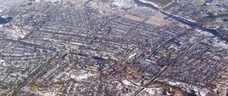
KOMSOMOLSK-ON-AMUR, a city in Russia, in the north. parts of the Khabarovsk Territory, the center of the Komsomolsky district. Us. 272.4 thousand people (2008). Located in the lower reaches of the river. Amur (stretched along the left bank for more than 30 km), at the confluence of the river. Silinka. A transport hub where railways, roads and waterways intersect. Airport.
The city was founded in 1932 on the site of the village. Perm (created in 1860 by peasant migrants from the Perm province) and the Nanai camp of Dzyomgi in connection with the beginning of farms. development of the Far Eastern region. The construction of the city was declared an All-Union shock Komsomol construction project (see Komsomol construction projects). In 1932–35 the regional center of the Far Eastern Territory, from 1939 - the Khabarovsk Territory.
Komsomolsk-on-Amur. View of the city. Administration of Komsomolsk-on-Amur
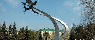
K.-na-A. built according to the general plans of 1939 (architects Lengorproekt under the direction of B.V. Danchich) and 1954. The building of Ch. highways in the spirit of the owls. neoclassicism con. 1930–50s (house on Mira Avenue, 1952; “house with a spire” on Lenin Street, 1953). In the 1970s a bridge was built across the river. Amur (1974–75), since 1977 the avenue has been built up. First builders. In the end 1990 – early 2000s churches were built: in honor of the Kazan Icon of the Mother of God (consecrated in 2001), the Prophet Elijah (2002–05). Monuments: V. I. Lenin (1957, sculptor A. M. Portyanko), Yu. A. Gagarin (1982, sculptor R. Kh. Muradyan).
In the city - State. technical University (1955, current name and status since 1994), Amur Humanitarian Pedagogical University. University (1954, current name and status since 2006). Gor. local historian museum (1939), The museum will depict. Arts (1966). Center. mountains fuck them. A. N. Ostrovsky (1934; 16 branches). Theatres: dramas (1933/34), “KnAM” (1985).
One of the largest industrial centers of the Far East and Transbaikalia. The most important industries: mechanical engineering, oil refining and ferrous metallurgy. Leading enterprises are aviation. production association named after Yu. A. Gagarin (1934; part of the Sukhoi aviation holding company; one of the largest Russian manufacturers of Su-27, Su-33, Su-35 fighters, Su-80 multifunctional aircraft, Be-103 amphibious aircraft and etc.), Amur Shipbuilding. plant (1933; one of the largest in the Far East; construction, modernization and repair of diesel submarines, ships of various classes and purposes, construction of facilities for the oil and gas sector), Amurmetal (the only electrometallurgical plant in the region for smelting electric steel, production -Wu long and sheet metal), an oil refinery (owned by the Rosneft oil company). There are also the Komsomolsk plant of hoisting and transport equipment (overhead, gantry and other cranes), Amurlitmash (electro-hydraulic machines for foundries, special machines for cleaning the surfaces of forgings, stampings, sheet and profile products, etc.), "Elkom" (welding electrodes), electrical engineering. plant (batteries for armored vehicles, agricultural equipment, trucks and cars), woodworking, light and food industries.
Story
It was founded near the ancient village of Milovskoye, which until 1918 was the volost center of the Shuisky district of the Vladimir province. According to statistical information from the mid-19th century, the village had 40 households and a population of 292 people; Orthodox Church of the Nativity of Christ, founded in 1771[23].
The emergence of the city of Komsomolsk is associated with the construction of the Ivanovo State District Power Plant, which began in the summer of 1927 in accordance with the GOELRO plan and the resolution of the USSR Council of Labor and Defense of May 6, 1927 on the construction of the Ivanovo-Voznesensk regional power station with a capacity of 40 thousand kilowatts, operating on local peat. In the same year, the first builders arrived at the construction site. The builders of the IvGRES were young men and women who were members of the Komsomol [23] - the construction was declared “Komsomol” and gave the name to the workers’ settlement “Komsomolsky”, and then to the city of Komsomolsk. In May 1928, the foundation stone for the main building of the power plant took place[24].
In 1930, the main power plant building was erected near the village of Milovskoye. On October 5, 1930, the first small turbogenerator was put into operation for the station’s own needs. This date is the beginning of the operation of the IvGRES station and the village of power engineers[25].
On January 26, 1931, the plenum of the village Construction Council of IvGRES considered the issue of the name of the village, and it was unanimously decided to name the village Komsomolsk
. The birth of a new village, named after the Komsomol, was legislated by a decree of the Presidium of the All-Russian Central Executive Committee of November 20, 1931. Over time, the settlement of power engineers merged with the settlement of railway workers. On August 28, 1950, the working village of Komsomolsk was transformed into a city of district subordination by decree of the Presidium of the Supreme Council of the RSFSR[25].
Komsomolsk
(Ivanovo region)
OKATO code:
24213501
Founded:
1931
Urban settlement since:
1931
City since:
1950 City of district subordination (Komsomolsky district, Ivanovo region)
Center:
Komsomolsky district
Telephone code (reference phone)
| 49352***** | 21-3-77 |
Deviation from Moscow time, hours:
0
Geographic latitude:
57°02′
Geographic longitude:
40°23′
Altitude above sea level, meters:
145 Sunrise and sunset times of the Sun and Moon in the city of Komsomolsk
Economy
| The section lacks links to sources. Information must be verifiable or it may be deleted. You can edit the article to add links to authoritative sources. This mark was set on May 12, 2011 . |
- Ivanovo PGU - branch of JSC Inter RAO - Electric Power Plants
- Factory for the production of test fabrics "Kommunar"
- plant for the production of electrical distribution equipment LLC PP "ALFA-ELTECH"
- timber processing enterprise
Notes
- ↑ 12
The permanent population of the Russian Federation by municipalities as of January 1, 2022 (Russian). Retrieved April 27, 2022. Archived May 2, 2022. - THE USSR. Administrative-territorial division of the union republics on January 1, 1980 / Comp. V. A. Dudarev, N. A. Evseeva. - M.: Izvestia, 1980. - 702 p. — P. 122.
- Lists of populated places of the Russian Empire. VI. Vladimir province. According to information from 1859 / Processed by Art. ed. M. Raevsky. — Central Statistical Committee of the Ministry of Internal Affairs. - St. Petersburg, 1863. - 283 p.
- List of populated places in the Vladimir province. — Central Statistical Committee of the Ministry of Internal Affairs. — Vladimir, 1907.
- All-Union Population Census of 1939. The size of the urban population of the USSR by urban settlements and intra-city areas (unspecified)
. Retrieved November 30, 2013. Archived November 30, 2013. - All-Union Population Census of 1959. The size of the urban population of the RSFSR, its territorial units, urban settlements and urban areas by gender (Russian). Demoscope Weekly. Access date: September 25, 2013. Archived April 28, 2013.
- All-Union Population Census of 1970 The size of the urban population of the RSFSR, its territorial units, urban settlements and urban areas by gender. (Russian). Demoscope Weekly. Access date: September 25, 2013. Archived April 28, 2013.
- ↑ 1 2 3
Results of the All-Russian Population Census of 2010, volume 1. Number and distribution of the population of the Ivanovo region
(unspecified)
. Access date: March 30, 2022. - ↑ 1234567891011
People's encyclopedia "My City". Komsomolsk (Ivanovo region) - All-Russian population census 2002. Volume. 1, table 4. Population of Russia, federal districts, constituent entities of the Russian Federation, districts, urban settlements, rural settlements - regional centers and rural settlements with a population of 3 thousand or more (unspecified)
. Archived from the original on February 3, 2012. - The size of the permanent population of the Russian Federation by cities, urban-type settlements and regions as of January 1, 2009 (unspecified)
. Retrieved January 2, 2014. Archived January 2, 2014. - Population of the Russian Federation by municipalities. Table 35. Estimated resident population as of January 1, 2012 (unspecified)
. Retrieved May 31, 2014. Archived May 31, 2014. - Population of the Russian Federation by municipalities as of January 1, 2013. - M.: Federal State Statistics Service Rosstat, 2013. - 528 p. (Table 33. Population of urban districts, municipal districts, urban and rural settlements, urban settlements, rural settlements) (undefined)
. Retrieved November 16, 2013. Archived November 16, 2013. - Table 33. Population of the Russian Federation by municipalities as of January 1, 2014 (unspecified)
. Access date: August 2, 2014. Archived August 2, 2014. - Population of the Russian Federation by municipalities as of January 1, 2015 (unspecified)
. Access date: August 6, 2015. Archived August 6, 2015. - Population of the Russian Federation by municipalities as of January 1, 2016 (Russian) (October 5, 2018). Retrieved May 15, 2022. Archived May 8, 2022.
- Population of the Russian Federation by municipalities as of January 1, 2022 (Russian) (July 31, 2017). Retrieved July 31, 2022. Archived July 31, 2022.
- Population of the Russian Federation by municipalities as of January 1, 2022 (Russian). Retrieved July 25, 2018. Archived July 26, 2022.
- Population of the Russian Federation by municipalities as of January 1, 2022 (Russian). Retrieved July 31, 2019. Archived May 2, 2022.
- Population of the Russian Federation by municipalities as of January 1, 2022 (Russian). Date accessed: October 17, 2022. Archived October 17, 2022.
- taking into account the cities of Crimea
- https://rosstat.gov.ru/storage/mediabank/bul_Chislen_nasel_MO-01-01-2021.rar Population of the Russian Federation by municipalities as of January 1, 2022 (1.85 Mb, 07/30/2021)
- ↑ 12
GPIB | [Vol. 6]: Vladimir province: ... according to information from 1859. — 1863. - https://visitivanovo.ru/areas/komsomolsk/sights/monuments/ivanovskaya-gres/
- ↑ 12
Page “History of the city Archived copy of April 7, 2014 on the Wayback Machine” on the website of the Administration of the Komsomolsk urban settlement.
Map
| Komsomolsk: maps |
Komsomolsk: photo from space (Google Maps) Komsomolsk: photo from space (Microsoft Virtual Earth)
| Komsomolsk. Nearest cities. Distances in km. on the map (in brackets along roads) + direction. Using the hyperlink in the distance , you can get the route (information courtesy of the AutoTransInfo website) | |||
| 1 | Teykovo | 22 (29) | SE |
| 2 | Novo-Talitsy | 28 () | IN |
| 3 | Ivanovo | 36 (56) | IN |
| 4 | Ilyinskoye-Khovanskoye | 37 (82) | Z |
| 5 | Lezhnevo | 41 (69) | SE |
| 6 | Gavrilov-Yam | 43 (53) | NW |
| 7 | Kokhma | 43 (68) | IN |
| 8 | Nerekhta | 47 (55) | WITH |
| 9 | Furmanov | 49 (84) | NE |
| 10 | Gavrilov Posad | 54 (77) | YU |
| 11 | Semibratovo (Yaroslavl region) | 59 (80) | NW |
| 12 | Rostov | 60 (93) | Z |
| 13 | Shuya | 63 (89) | IN |
| 14 | Volgorechensk | 64 (113) | NE |
| 15 | Ishnya (Yaroslavl region) | 65 () | Z |
| 16 | Privolzhsk | 66 (103) | NE |
| 17 | Suzdal | 66 (87) | YU |
| 18 | Petrovskoye (Yaroslavl region) | 67 (118) | Z |
| 19 | Savino | 70 (104) | SE |
| 20 | Nekrasovskoe (Yaroslavl region) | 71 (132) | WITH |
| 21 | Yuriev-Polsky | 73 (123) | SW |
| 22 | Yaroslavl | 73 (93) | NW |
| 23 | Krasnoe-on-Volga (Kostroma region) | 74 (131) | NE |
| 24 | Borisoglebsky (Yaroslavl region) | 78 (111) | Z |
| 25 | Springs | 81 (106) | IN |
| 26 | Plyos | 81 (121) | NE |
| 27 | Kameshkovo | 84 (126) | SE |
| 28 | Karavaevo (Kostroma region) | 87 () | NE |
| 29 | Kostroma | 87 (96) | NE |
| 30 | Palekh | 93 (121) | IN |
| 31 | Kovrov | 93 (157) | SE |
a brief description of
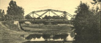
Komsomolsk is located on the river. Ukhtokhma (tributary of the Uvodi), 34 km west of Ivanovo. Railway station.
Territory (sq. km): 6
Information about the city of Komsomolsk on the Russian Wikipedia website
Historical sketch
It emerged as a settlement of peat miners and power engineers in 1931 in connection with the construction of the Ivanovskaya State District Power Plant (it worked on peat).
Workers' village of Komsomolsk since 1931. City since 1950.
Economy
Factories: experimental mechanical (repair of hydraulic equipment, spare parts for truck cranes), "Kranelektroapparat" (low-voltage electrical equipment), "Kommunar" (cotton yarn), "Alpha" (machine electromagnets).
Timber industry enterprise: harvesting and export of wood, production of lumber. Raipromkombinat, bakery, dairy plant.
In the Komsomolsk region, rye, oats, wheat, barley, peas, rapeseed, potatoes and vegetables are grown. Dairy and meat farming.
Deposits of peat, clay, sand and gravel mixtures.
Architecture, sights
Church of the Nativity (1771).
In the village of Pistsovo (first mentioned in 1568) there is the Resurrection Church (1748).
| Population by year (thousands of inhabitants) | |||||||
| 1939 | 15.7 | 1998 | 10.6 | 2008 | 9.0 | 2016 | 8.5 |
| 1959 | 11.1 | 2000 | 10.3 | 2010 | 8.7 | 2017 | 8.4 |
| 1970 | 12.3 | 2001 | 10.1 | 2011 | 8.7 | 2018 | 8.2 |
| 1979 | 12.3 | 2003 | 9.6 | 2012 | 8.7 | 2019 | 8.1 |
| 1989 | 11.6 | 2005 | 9.4 | 2013 | 8.7 | 2020 | 8.0 |
| 1992 | 11.5 | 2006 | 9.2 | 2014 | 8.6 | 2021 | 8.0 |
| 1996 | 11.0 | 2007 | 9.1 | 2015 | 8.6 | ||