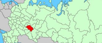
The Republic of Tatarstan includes districts and cities of republican significance, the list of which is established by the Constitution of the Republic of Tatarstan (43 municipal districts). The total area of Tatarstan is 67,836 km². The length of the territory of the republic is 290 km from north to south and 460 km from west to east.
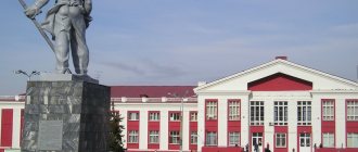
The capital of the Republic of Tatarstan, the million-plus city of Kazan, is located on the left bank of the Volga, at the confluence of the Kazanka River, in the eastern part of the European continent.
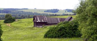
In addition to the capital, the Republic also has 21 cities, 19 urban-type settlements, as well as large rural settlements. The most populated region of Tatarstan is Zelenodolsk, the least populated is Elabuga. Tatarstan is the only region of the Russian Federation that has more than one million-plus urban agglomeration - Kazan and Naberezhnye Chelny (Nizhne-Kama).
The population of the republic is 3.86 million people, of which 76.3% are urban residents (as of 2015), population density is 56.82 people/km2.
Cities of Tatarstan
| № | City | Area | Population | Telephone code |
| 1 | Kazan | Urban district | 1 205 651 | 843 |
| 2 | Naberezhnye Chelny | Urban district | 524 444 | 8552 |
| 3 | Nizhnekamsk | Nizhnekamsk district | 235 448 | 8555 |
| 4 | Almetyevsk | Almetyevsky district | 151 157 | 8553 |
| 5 | Zelenodolsk | Zelenodolsk district | 98 462 | 84371 |
| 6 | Bugulma | Bugulminsky district | 86 747 | 85514 |
| 7 | Elabuga | Elabuga district | 72 929 | 85557 |
| 8 | Leninogorsk | Leninogorsk district | 63 635 | 85515 |
| 9 | Chistopol | Chistopolsky district | 61 110 | 84342 |
| 10 | Zainsk | Zainsky district | 41 046 | 85558 |
| 11 | Aznakaevo | Aznakaevsky district | 34 720 | 85511 |
| 12 | Nurlat | Nurlatsky district | 33 102 | 84345 |
| 13 | Mendeleevsk | Mendeleevsky district | 22 200 | 85549 |
| 14 | Bavly | Bavlinsky district | 22 114 | 85519 |
| 15 | Buinsk | Buinsky district | 20 854 | 84374 |
| 16 | Agryz | Agryz district | 19 738 | 85551 |
| 17 | Menzelinsk | Menzelinsky district | 16 952 | 85555 |
| 18 | Mamadysh | Mamadyshsky district | 15 528 | 85563 |
| 19 | Tetyushi | Tetyushsky district | 11 449 | 84373 |
| 20 | Bulgarian | Spassky district district | 85 42 | 84347 |
| 21 | Laishevo | Laishevsky district | 82 28 | 84378 |
| 22 | Innopolis | Zelenodolsk district | 10 | 84371 |
New mergers, divisions and ephemeral regions
Since then, the number of districts of the Tatar Autonomous Soviet Socialist Republic began to decrease. In 1954, the Kornoukhovsky, Matveevsky and Mortovsky districts were abolished. A year later, the Novopismyansky district was renamed Leninogorsky. In 1956, Podberezinsky, Churilinsky, Yukhmachinsky and Yamashinsky districts were abolished. Kzyl-Yulsky district was renamed Tukaevsky. In 1957, two more districts were renamed: Budenovsky to Tsilninsky and Voroshilovsky to Yana-Yulsky. A year later, three more districts were renamed: Tsipyinsky to Baltasinsky, Yudinsky to Zelenodolsky, Yutazinsky to Urussky. In the same year, the Kzyl-Armeisky, Telmansky, Tenkovsky and Tumutuksky districts were abolished.
In 1959, the Aktash, Atninsky, Bolshetarkhansky, Kalininsky, Kzyl-Yulduzsky, Stolbishchensky, Tyulyachinsky, Tsilninsky, Shugurovsky and Yana-Yulsky districts were abolished. In 1960, the Krasnoborsky and Kuznechikha districts were abolished, and in 1963 - Agryzsky, Aznakaevsky, Aksubaevsky, Aktanyshsky, Alekseevsky, Alkeevsky, Apastovsky, Bavlinsky, Baltasinsky, Bilyarsky, Bondyuzhsky, Verkhneuslonsky, Vysokogorsky, Drozhzhanovsky, Dubyazsky, Zainsky, Kaybitsky, Kamsko-Ustinsky , Kukmorsky, Laishevsky, Muslyumovsky, Novosheshminsky, Nurlatsky, Pervomaisky, Rybno-Slobodsky, Takanyshsky, Tukaevsky, Urussky and Sheremetyevsky.
Already at the end of 1963, the process of restoring the abolished districts began: the first of them was the Aznakaevsky district. In 1964, Agryzsky, Alekseevsky, Alkeevsky and Apastovsky districts were formed, and in 1965 - Aksubaevsky, Aktanyshsky, Bavlinsky, Baltasinsky, Verkhneuslonsky, Vysokogorsky, Kamsko-Ustinsky, Kukmorsky, Laishevsky, Muslyumovsky, Nizhnekamsky, Rybno-Slobodsky and Cheremshansky.
The Drozhzhanovsky district was formed in 1966, and the Zainsky district in 1972. In 1976, the Chelny district was renamed Tukaevsky. The Novosheshminsky district was formed in 1983, the Mendeleevsky district in 1985, and the Atninsky district in 1990.
After the transformation of the Tatar Autonomous Soviet Socialist Republic into the Republic of Tatarstan (1990), Kaybitsky, Tyulyachinsky and Yutazinsky districts were formed (1991). Kuibyshevsky district was renamed Spassky (1991), and Oktyabrsky district was renamed Nurlatsky (1997).
At the beginning of the issue, we noted the ephemeral republic - the Tatar-Bashkir Soviet. In the history of administrative-territorial division there were also ephemeral regions. On May 8, 1952, two regions were formed on the territory of the Tatar Autonomous Soviet Socialist Republic: Kazan and Chistopol. On February 21, 1953, the third region was established - Bugulma. However, on April 30, all three regions were abolished. The reader can imagine what it was like for newly appointed party and Soviet regional nomenklatura workers to lose their career prospects. Well, let's not worry about them so much.
The Bolsheviks used the new territorial unit "canton", used by General Osip Igelstrom to control the Bashkir and Meshcheryatsky troops
Urban-type settlements of Tatarstan
| № | Settlement | Area | Population | Telephone code |
| 1 | Arsk | Arsky district | 19 681 | 84366 |
| 2 | Kukmor | Kukmorsky district | 17 479 | 84364 |
| 3 | Vasilyevo | Zelenodolsk district | 17 420 | 84371 |
| 4 | Kamskie Polyany | Nizhnekamsk district | 15 645 | 8555 |
| 5 | Jalil | Sarmanovsky district | 13 613 | 85559 |
| 6 | Alekseevskoe | Alekseevsky district | 11 615 | 84341 |
| 7 | Urussu | Yutazinsky district | 10 577 | 85510 |
| 8 | Lower Maktama | Almetyevsky district | 10 059 | 8553 |
| 9 | Aksubaevo | Aksubaevsky district | 9 984 | 84 344 |
| 10 | Aktobe | Aznakaevsky district | 9 120 | 85 511 |
| 11 | Rich Subs | Sabinsky district | 8 372 | 84362 |
| 12 | Baltasi | Baltasinsky district | 8 115 | 84368 |
| 13 | Nizhniye Vyazovye | Zelenodolsk district | 8 060 | 84371 |
| 14 | Rybnaya Sloboda | Rybno-Slobodsky district | 7 755 | 84361 |
| 15 | Apastovo | Apastovsky district | 5 306 | 84376 |
| 16 | Karabash | Bugulminsky district | 4 955 | 85514 |
| 17 | Kama Ustye | Kamsko-Ustinsky district | 4 496 | 84377 |
| 18 | Kuibyshevsky Zaton | Kamsko-Ustinsky district | 2 644 | 84377 |
| 19 | Tenishevo | Kamsko-Ustinsky district | 762 | 84377 |
Tatar autonomy: cantons and regions
For the first time, Tatar autonomy with many state attributes was created in June 1920. Initially, the Autonomous Tatar Soviet Republic (it became a familiar TASSR only in 1937) was divided into 10 cantons: Arsky, Bugulma, Buinsky, Laishevsky, Mamadyshsky, Menzelinsky, Sviyazhsky, Spassky, Tetyushsky and Chistopolsky.
In 1921, Agryz, Yelabuga and Chelny cantons were created. Three years later, the Agryz canton was abolished. At the same time, two districts were formed: Agryzsky and Bondyuzhsky.
I must warn the reader that it is in vain to look for some kind of logic in all these administrative-territorial transformations. It was some kind of orgy of zoning: a sea of articles in periodicals, dozens of books and brochures. Each has its own proposals for zoning. Some were quite reasonable and backed up by economic calculations, but the majority had only one argument - “why not?”
In 1927, seven new districts were formed: Voskresensky, Laishevsky, Nurlatsky, Rybno-Slobodsky, Sviyazhsky, Tenkovsky and Ulyanovsky. At the same time, the Laishevsky, Sviyazhsky and Tetyushsky cantons were abolished. Soon Voskresensky district was renamed Kazansky, and Ulyanovsky - Kaybitsky. A year later, the Elabuga canton was abolished.
Map of the TASSR 1928
On July 23, 1930, all cantons of the Tatar Autonomous Soviet Socialist Republic were abolished. Instead of them, the following districts were formed: Aksubaevsky, Aktanyshsky, Aktashsky, Alekseevsky, Alkeevsky, Almetyevsky, Apastovsky, Arsky, Bavlinsky, Bilyarsky, Bugulminsky, Buinsky, Drozhzhanovsky, Dubyazsky, Elabuga, Kamsko-Ustinsky, Krasnoborsky, Kukmorsky, Mamadyshsky, Menzelinsky, Muslyumovsky, Novosheshminsky , Oktyabrsky, Pervomaisky, Pestrechinsky, Sabinsky, Sarmanovsky, Spassky, Takanishsky, Tetyushsky, Tukaevsky, Tumutuksky, Tyuntersky, Chelninsky, Chistopolsky, Sheremetyevsky and Shugurovsky.
In 1931, the Tumutuksky district was renamed Aznakaevsky, the Verkhneuslonsky district was formed, and the Bondyuzhsky, Sviyazhsky and Tenkovsky districts were abolished. A year later, the Takanishsky district was abolished, and Tyuntersky was renamed Baltasinsky.
In 1935, 17 new districts were formed: Bondyuzhsky, Budenovsky, Voroshilovsky, Vysokogorsky, Zainsky, Kalininsky, Kzyl-Armeysky, Kzyl-Yulduzsky, Kzyl-Yulsky, Kuznechikhinsky, Novopismyansky, Takanishsky, Telmansky, Tenkovsky, Tumutuksky, Tyulyachinsky and Yutazinsky. Spassky district was renamed Kuibyshevsky. Three years later, Baltasinsky district was renamed Tsipyinsky, and Tukaevsky - Atninsky. The Kazansky district was abolished, Bolshetarkhansky, Stolbishchensky and Yudinsky districts were formed.
In 1944, Kosteneevsky (soon renamed Mortovsky), Matveevsky, Podberezinsky, Saltanovsky, Churilinsky, Yukhmachinsky and Yamashinsky were formed. Two years later, Saltanovsky district was renamed Kornoukhovsky.
In 1948, the territory of the Tatar Autonomous Soviet Socialist Republic was divided into 70 districts and three cities of republican subordination (Kazan, Zelenodolsk and Chistopol) - this was the apotheosis of the fragmentation of the ATD of the republic.
Map of the TASSR 1930
Large rural settlements (district centers) of Tatarstan
| № | District center | Area | Population | Telephone code |
| 1 | High mountain | Vysokogorsky district | 9 589 | 84365 |
| 2 | Sarmanovo | Sarmanovsky district | 9 043 | 85559 |
| 3 | Aktanysh | Aktanysh district | 8 923 | 85552 |
| 4 | Pestretsy | Pestrechinsky district | 8 094 | 84367 |
| 5 | Muslyumovo | Muslyumovsky district | 7 342 | 85556 |
| 6 | Cheremshan | Cheremshansky district | 5 930 | 84396 |
| 7 | Bazaar Mataki | Alkeevsky district | 5 899 | 84346 |
| 8 | Novosheshminsk | Novosheshminsky district | 4 561 | 84348 |
| 9 | Verkhniy Uslon | Verkhneuslonsky district | 4 498 | 84379 |
| 10 | Big Atnya | Atninsky district | 3 536 | 84369 |
| 11 | Tyulyachi | Tyulyachinsky district | 3 259 | 84360 |
| 12 | Old Drozhzhanoe | Drozhzhanovsky district | 3 209 | 84375 |
| 13 | Big Kaybitsy | Kaybitsky district | 1 600 | 84370 |
Population of the Russian Federation by municipalities as of January 1, 2015.
About the Tatar-Bashkir Soviet Republic
Two months have already passed since the Third Congress of Soviets, which proclaimed the federal system of the Russian Republic, and the outskirts, still busy establishing Soviet power locally, have not yet spoken clearly and definitely about specific forms of federation. Apart from Ukraine, now brutally tormented by “civilized” rapists, and Crimea and the Don region, which have already spoken out for federal ties with Russia, Tatar-Bashkiria seems to be the only region whose revolutionary organizations have definitely drawn up a plan for federation with Soviet Russia. We mean that aptly outlined general scheme of organization of the Tatar-Bashkir Soviet Republic, which everyone is talking about now and which was developed by the most influential Soviet organizations of the Tatars and Bashkirs.
Meeting the wishes of the Tatar-Bashkir revolutionary masses and based on the decision of the Third Congress of Soviets, which proclaimed Russia the Federation of Soviet Republics, the People's Commissariat for Nationalities, in accordance with the instructions of the Council of People's Commissars, developed the following regulations on the Tatar-Bashkir Soviet Republic of the Russian Soviet Federation. The Constituent Congress of Soviets of Tatar-Bashkiria, the convening of which is just around the corner, will develop specific forms and details of this provision. The Central Executive Committee and the Council of People's Commissars will approve - we have no reason to doubt this - the results of the work of this congress.
People's Commissar I. Stalin “Pravda” No. 53, March 23, 1918
Article No. 394.
Decree of the People's Commissariat for National Affairs. About the Tatar-Bashkir Soviet Republic.
Based on the principle of national self-determination of the working masses, approved by the 3rd All-Russian Congress of Soviets, the People's Commissariat for Nationalities, in agreement with the Commissariat for Muslim Affairs of Central Russia, developed the following regulations on the Tatar-Bashkir Soviet Republic:
1) The territory of the Southern Urals and the Middle Volga region is declared the Tatar-Bashkir Soviet Republic of the Russian Soviet Federation.
2) When determining the boundaries, the basis is the project developed by the Bashkir and Tatar revolutionary organizations (the entire Ufa province, the Bashkir part of the Orenburg province, the Kazan province, with the exception of the Chuvash-Cheremis part, and the adjacent Muslim parts of Perm, Vyatka, Simbirsk and Samara provinces). The final determination of the boundaries of the Republic is left to the Founding Congress of Soviets of this Republic.
3) The political and economic relationship between the western part of the Republic and Bashkirdistan is determined by the Founding Congress of Soviets of the Tatar-Bashkir Republic.
4) The organization of the commission for convening the Founding Congress of Soviets is entrusted to the Commissariat for Muslim Affairs of Central Russia.
Signed by: People's Commissar for Nationalities I. Dzhugashvili-Stalin. Commissioner for Muslim Affairs of Central Russia Mulla-Nur-Vakhitov. Members of the Commissariat - Manatov, Ibragimov.
March 22 (9), 1918.