City in Novosibirsk region, Russia
| Barabinsk Barabinsk | |
| City [1] | |
| Barabinsk railway station of the Trans-Siberian Railway | |
| Flag | |
| Location of Barabinsk | |
| Barabinsk Location of Barabinsk Show map of Russia Barabinsk Barabinsk (Novosibirsk region) Show map of Novosibirsk region | |
| Coordinates: 55°21'N 78°21'E / 55.350°N W. 78.350°E / 55,350; 78.350 Coordinates: 55°21'N 78°21'E. / 55.350°N W. 78.350°E / 55,350; 78,350 | |
| A country | Russia |
| Federal subject | Novosibirsk region [2] |
| Based | late 19th century [3] |
| City status from | 1917 [3] |
| Height | 115 m (377 ft) |
| population size (2010 Census) [4] | |
| • General | 30 394 |
| • Evaluate (2018) [5] | 28 941 (-4,8 % ) |
| Administrative status | |
| • Subordinate | City of Barabinsk [2] |
| • Capital from | City of Barabinsk [2], Barabinsky district [1] |
| Municipal status | |
| • Municipal district | Barabinsky municipal district [6] |
| • Urban village | Urban settlement Barabinsk [6] |
| • Capital from | Barabinsky municipal district [7], urban settlement of Barabinsk |
| Timezone | UTC+7 (MSK+4[8]) |
| Postal code [9] | 630833, 632330–632332, 632334–632336, 632338 |
| Dial code(s) | +7 38361 |
| OKTMO ID | 50604101001 |
| Web site | administration-barabinsk.rf |
Barabinsk
(Russian: Barabinsk) is a city in Novosibirsk Oblast, Russia, located in the Barabinsk steppe on the Trans-Siberian Railway between Omsk and Novosibirsk. Population: 30,394 (2010 census); [4] 32,501 (2002 census); [10] 36,501 (1989 census). [eleven]
Administrative and municipal status[edit]
As part of the administrative divisions, Barabinsk serves as the administrative center of the Barabinsky District, [1] although it is not part of it. [2] As an administrative division, it is included separately as the city of Barabinsk
[2] - an administrative unit with a status equal to that of districts.
[ Edit
] As a municipal division, the city of Barabinsk is included within the Barabinsky municipal district as
the Barabinsky urban settlement
. [6]
The city of Barabinsk in the Novosibirsk region
General information about the city of Barabinsk
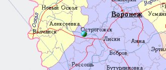
Barabinsk is the regional center of the district of the same name in the west of the Novosibirsk region, which is located near the Om River (a tributary of the Irtysh), at a distance of 315 km from Novosibirsk. Railway station on the Trans-Siberian Railway. The city's population is about 30 thousand people. “Baraba” is translated from Tatar as “high water.” The Barabinsky district is really rich in water resources, there are a large number of lakes, including part of such a large one as Lake Chany. Swamps are often found in the area.
History of the city of Barabinsk
On the site of present-day Barabinsk, there were lands of working peasants from the village of Novo-Chernovaya. A certain area of these lands was taken and allocated for the construction of a railway station on the Trans-Siberian Railway. At first there was a village here, at the Kainsk station in which the builders of the station and the railway lived; it appeared here at the end of the 19th century and belonged to the Kainsky district of the Tomsk province.
Over time, the village grew, a station, a temple, and in 1897 a parish school appeared here, which a year later was named after John of Kronstadt. At the end of the 19th century, 2 medical stations, pharmacies and a hospital appeared at the station.
In 1910, 2 brick factories were built. The surviving samples of bricks produced here show the high quality of the products.
The village grew uncontrollably and in 1917 it received the status of a city with the name Barabinsk. Because the new government tried to arrange the political structure of the city, not paying attention to the problems of the residents. Armed clashes between local residents and the new government were not uncommon; the city passed from the hands of the Red Guards to the hands of the White Guards several times, and only at the end of 1919 was Soviet power established in it. In 1920, Barabinsk lost its status as a county town, the center was moved to Kainsk, the city did not suffer from this and its growth continued. The Great Patriotic War did not stop its development. In 1942, a special grinding mill was built here, which completely supplied the residents of the area with bread and saved them from starvation during the war and post-war times, from which residents of other regions suffered greatly. An elevator and a feed mill were built in the city. The plant is still in operation, and its products are of high quality.
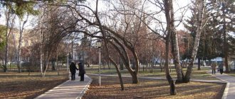
Sights of Barabinsk
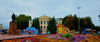
The local history museum, created in 1984, is the main attraction of the city. It displays ethnographic exhibitions and archaeological finds found in these places, and local artists organize their exhibitions. The city has a monument to Vladimir Lenin. The city station is the city station, which is almost 150 years old. The building has been perfectly preserved to this day, and in 2011 it was reconstructed and renovated.
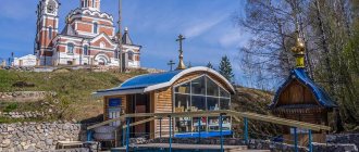
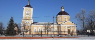
The Chapel of St. George the Victorious was built in the city in 1997, and the Church of the Mother of God is currently under construction.
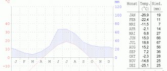
Climate[edit]
Barabinsk has a humid continental climate (Köppen climate classification Dfb
) with very cold winters and warm summers. Precipitation is quite low, but from June to September there is slightly more precipitation than at other times of the year.
| Climate data for Barabinsk | |||||||||||||
| Month | Jan | Feb | Mar | Apr | May | Jun | Jul | Aug | Sep | October | But I | December | Year |
| Record high °C (°F) | 3,5 (38,3) | 3,5 (38,3) | 10,0 (50,0) | 28,3 (82,9) | 36,2 (97,2) | 37,8 (100,0) | 37,8 (100,0) | 35,5 (95,9) | 32,9 (91,2) | 23,9 (75,0) | 10,5 (50,9) | 7,0 (44,6) | 37,8 (100,0) |
| Average high °C (°F) | -14,5 (5,9) | -12,7 (9,1) | -5,2 (22,6) | 6,6 (43,9) | 17,5 (63,5) | 23,3 (73,9) | 25,1 (77,2) | 22,1 (71,8) | 16,0 (60,8) | 6,6 (43,9) | -5,1 (22,8) | -11,8 (10,8) | 5,7 (42,2) |
| Daily average °C (°F) | -19,1 (-2,4) | -17,5 (0,5) | -10,9 (12,4) | 0,9 (33,6) | 10,7 (51,3) | 16,8 (62,2) | 18,9 (66,0) | 15,9 (60,6) | 9,8 (49,6) | 1,5 (34,7) | -9,1 (15,6) | -16,3 (2,7) | 0,1 (32,2) |
| Average low °C (°F) | -23,5 (-10,3) | -22,2 (-8,0) | -15,9 (3,4) | -3,8 (25,2) | 4,5 (40,1) | 10,4 (50,7) | 12,9 (55,2) | 10,3 (50,5) | 4,8 (40,6) | -2,3 (27,9) | -13,0 (8,6) | -20,8 (-5,4) | -4,9 (23,2) |
| Record low °C (°F) | -47,9 (-54,2) | -44,9 (-48,8) | -41,2 (-42,2) | -29,5 (-21,1) | -13,0 (8,6) | −3,3 (26,1) | 2,5 (36,5) | -2,2 (28,0) | -8,0 (17,6) | -25,1 ( -13,2 ) | -41,7 (-43,1) | -47,5 (-53,5) | -47,9 (-54,2) |
| Average precipitation, mm (inches) | 18,0 (0,71) | 13,2 (0,52) | 12,7 (0,50) | 18,3 (0,72) | 28,3 (1,11) | 49,4 (1,94) | 63,1 (2,48) | 50,9 (2,00) | 33,7 (1,33) | 33,1 (1,30) | 26,6 (1,05) | 22,4 (0,88) | 369,7 (14,54) |
| Average number of days with precipitation (≥ 0.1 mm) | 13,7 | 11,4 | 11.2 | 8.0 | 8,4 | 9,3 | 7,7 | 8,8 | 8,5 | 12,5 | 17,6 | 16,4 | 133,5 |
| Average relative humidity (%) | 80,1 | 79,2 | 76,8 | 63,9 | 55,9 | 66,3 | 72,7 | 73,6 | 71,4 | 75,5 | 83,9 | 81,6 | 73,4 |
| Average sunshine hours per month | 79,1 | 130,2 | 182,9 | 234,0 | 289,9 | 313,5 | 316,2 | 257,3 | 177,0 | 108,5 | 67,5 | 60,5 | 2216,6 |
| Source: climbase.ru (1933-2011) [12] | |||||||||||||
Links[edit]
Notes[edit]
- ^ abc State Committee of the Russian Federation on Statistics. Committee of the Russian Federation for Standardization, Metrology and Certification. No. OK 019-95 January 1, 1997 “All-Russian classifier of objects of administrative-territorial division. Code 50 204", ed. changes No. 278 / 2015 dated January 1, 2016. (Goskomstat of the Russian Federation. Committee of the Russian Federation for Standardization, Metrology and Certification. No. OK 019-95 January 1, 1997. Russian classification of administrative divisions) (OKATO).
Code 50 204 , as amended by Amendment No. 278/2015 of 01/01/2016). - ^ abcde State Committee of the Russian Federation on Statistics. Committee of the Russian Federation for Standardization, Metrology and Certification. No. OK 019-95 January 1, 1997 “All-Russian classifier of objects of administrative-territorial division. Code 50 405", ed. changes No. 278 / 2015 dated January 1, 2016. (Goskomstat of the Russian Federation. Committee of the Russian Federation for Standardization, Metrology and Certification. No. OK 019-95 January 1, 1997. Russian classification of administrative divisions) (OKATO).
Code 50 405 , as amended by Amendment No. 278/2015 of 01/01/2016). - ^ abc Encyclopedia of Russian Cities
. Moscow: Great Russian Encyclopedia. 2003. p. 37. ISBN 5-7107-7399-9. - ^ a b Federal State Statistics Service (2011). “All-Russian Population Census 2010. Volume 1" [All-Russian Population Census 2010, vol. 1]. All-Russian Population Census 2010 [All-Russian Population Census 2010]
. Federal State Statistics Service. - "26. The size of the permanent population of the Russian Federation by municipalities as of January 1, 2022". Federal State Statistics Service. Retrieved January 23, 2022.
- ^ abc Law No. 200-OZ
- Law No. 246-OZ
- "On the Calculation of Time". Official Internet portal of legal information
. June 3, 2011. Retrieved January 19, 2022. - Post office. Information and computing center of OASU RPO. ( Post office
).
Search objects postal service ( postal Search objects
) (in Russian) - ↑
Federal State Statistics Service of Russia (May 21, 2004).
“The population of Russia, the constituent entities of the Russian Federation as part of federal districts, urban settlements, settlements, settlements of 3 thousand or more people” [Population of Russia, its federal districts, federal districts, districts, urban settlements, rural settlements - administrative centers and rural settlements with a population of more than 3000] (XLS). All-Russian Population Census of 2002 [All-Russian Population Census of 2002]
. - “All-Union Population Census of 1989. The current population of union and autonomous republics, autonomous regions and districts, territories, negative phenomena, urban settlements and rural district centers” [All-Union Population Census of 1989: current population of union and autonomous republics, Autonomous regions and districts , territories, regions, districts, urban settlements, villages performing the functions of district administrative centers. All-Union Population Census of 1989 [All-Union Population Census of 1989]
.
Institute of Demography of the National Research University: Higher School of Economics [Institute of Demography of the National Research University: Higher School of Economics]. 1989 - via Demoscope Weekly
. - "Barabinsk, Russia". Climatebase.ru. Retrieved January 23, 2013.
Sources [edit]
- Novosibirsk Regional Council of Deputies. Law No. 200-OZ of June 2, 2004 “On the status and boundaries of municipalities of the Novosibirsk region,” as amended. Law No. 548-OZ of April 29, 2015 “On the abolition of the village of Ivanovka of the municipal formation of the Chuvashinsky Village Council of the Northern District of the Novosibirsk Region and on amendments to Article 4 of the Law of the Novosibirsk Region “On the status and boundaries of municipalities of the Novosibirsk Region””. Came into force 10 days from the date of official publication. Published: “Soviet Siberia”, No. 108, June 9, 2004 (Novosibirsk Regional Council of Deputies. Law No. 200-OZ dated June 2, 2004 “ On the status and boundaries of municipalities of the Novosibirsk Region”
as amended by Law No. 548-OZ dated April 29, 2015
On the abolition of the village of Ivanovka in the municipal formation Chuvashinsky Village Council of the Northern District of the Novosibirsk Region and on amendments to Article 4 of the Law of the Novosibirsk Region "On the status and boundaries of municipalities of the Novosibirsk Region"
. Valid after 10 days from the date of official publication.) . - Novosibirsk Regional Council of Deputies. Law No. 246-OZ of December 17, 2004 “On the administrative centers of municipal and rural settlements of the Novosibirsk region,” as amended. Law No. 69-OZ of December 5, 2006 “On amendments to the Law of the Novosibirsk Region” in the administrative centers of municipal districts and settlements of the Novosibirsk Region “”. Came into force on the date of official publication. Published: “Soviet Siberia”, No. 252, December 29, 2004 (Novosibirsk Regional Council of Deputies. Law of December 17, 2004 No. 246-OZ “ On the administrative centers of municipal districts and rural settlements of the Novosibirsk Region”
as amended by Law No. 69-OZ dated December 5, 2006
On amendments to the Law of the Novosibirsk Region “On administrative centers of municipal districts and rural settlements of the Novosibirsk Region"
. Valid from the date of official publication.).
External links [edit]
- Official website of Barabinsk (in Russian)
- Unofficial website of Barabinsk (in Russian)
| vteAdministrative divisions for the Novosibirsk region | |||
| Administrative center: Novosibirsk • Rural area. | |||
| Districts |
| ||
| Cities and towns |
| ||
| Urban settlements |
| ||
Barabinsk
(Novosibirsk region)
OKATO code:
50405
Founded:
1893
City since:
1917 City of district subordination (Barabinsky district, Novosibirsk region)
Center:
Barabinsky district
Telephone code (reference phone)
| 38361***** | — |
| 383612**** | 29-20 |
Deviation from Moscow time, hours:
4
Geographical latitude:
55°21′
Geographical longitude:
78°21′
Altitude above sea level, meters:
115 Sunrise and sunset times of the Sun and Moon in the city of Barabinsk