The Republic of Dagestan has officially existed since 1921. In this regard, it is very young, although some of its cities are very ancient. This is a real country of mountains, where most of the territory is located at high altitudes. Despite this, the cities of Dagestan can hardly be called high-mountainous, because most of them are located closer to the Caspian Sea, and the most significant ones are located on a narrow strip along the coast.
Districts and cities of Dagestan
The capital of the republic a little later than its formation was the city of Makhachkala, which is currently the administrative center. It’s easy to see how many cities there are in Dagestan on the map and count them on your fingers. In total, there are 10 cities in the republic, each is the administrative center for its own urban district. Since 2013, the territory of the republic has been divided into 4 large territorial districts. Each district can be assigned a corresponding list of cities in Dagestan.
- Central district: Makhachkala, Kizilyurt, Buynaksk, Kaspiysk and Izberbash.
- Northern district: Yuzhno-Sukhumsk, Kizlyar, Khasavyurt.
- The southern district includes Dagestan Lights and Derbent.
- The mountain district includes Khunzakh, Botlikh, Akushinsky and many other areas.
So, we figured out how many cities there are in Dagestan, but besides them there are also urban-type settlements (there are 12 of them). The territory of the republic is also divided into municipal districts, there are 41 in total, and there are settlements in them.
Unique land
One of the most hospitable and most beautiful corners of Dagestan is the Dakhadaevsky district. The past, present and future are closely intertwined here. Every year, hundreds of tourists come here to see with their own eyes Kubachi - a village of goldsmiths who make filigree jewelry, jugs, dishes, sabers and much more.
No matter what corner of Dagestan you go to, you will find amazing places everywhere, you will meet amazing people everywhere. It is impossible to describe in words the beauty of the local canyons, mountains, rivers, the beauty of the souls of the people inhabiting the republic. Dagestan needs to be felt. Dagestan is a must see. You need to live in Dagestan!
Brief description of cities
As a rule, large cities of Dagestan are located on flat territory in the coastal zone. All of them used to be small villages where residents were engaged in traditional crafts, until industry began to actively develop in the 20th century during Soviet times. In the Republic of Dagestan, not only agriculture is currently developed, but also various types of industry, although during perestroika many enterprises fell into decay. The ethnic composition of the population is very diverse; Dagestanis and Russians live here, as well as other representatives of different nationalities.
National traditions
Separately, all researchers note the unique folklore of Dagestan. The basis of the spiritual heritage of the republic is the multilingualism and multinationality of the region. Oral poetry has been developed since ancient times. It has its own ritual poetry, a mythological genre.
Fine art began to develop only in the 20th century. There were both artists and sculptors in the republic. But decorative and applied art has its roots in the Bronze Age. Nowadays in Dagestan they make jewelry that is decorated with enamel, niello, and engraving. Certain regions are known for their copper coinage, wooden products with silver incisions or bone inlays, painted ceramics, and carpets.
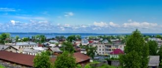
Makhachkala
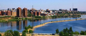
This is the largest city in the Republic of Dagestan, its population is 588 thousand people. It is also the capital, political and economic center.
Once upon a time, Tarki-aul was located on the site of the city; caravans that went to the ancient city of Derbent stopped here. In 1844, the Petrovskoye fortress appeared here, and then the settlement received the name Petrovsk. The development of the city began at the end of the 19th century, when a railway was built from Rostov to the capital of Azerbaijan, Baku. Industrial enterprises began to appear here, and the population gradually grew. In 1921, the city acquired a new name - Makhachkala, the name comes from the name of the local revolutionary Makhach Dakhadayev.
In the 30s the city began to develop rapidly. Houses were built, streets were developed, water supply, hospitals and schools appeared, and in some places defense enterprises appeared. With the beginning of the 90s, the economy declined. Businesses were closing. In addition, radicals of extremist Islamic movements began to appear here. Despite this difficult period, the city is gradually being restored and improved. Today it is one of the most significant cities in the Caucasus; it is a scientific and economic center.
Urban settlements
- Leninkent
Population 16,771 (2020).
- Semender
Population 14,678 (2020).
- Tarki
Population 15,850 (2020).
- Alburikent
Population 12,800 (2020).
- Shamkhal
Population 12,199 (2020).
- Beliji
Population 10,903 (2020).
- Mammadkala
Population 10,860 (2020).
- New Kyakhulai
Population 10,376 (2020).
- Sulak
Population 8,638 (2020).
- Kyakhulai
Population 7,447 (2020).
- Tube
Population 7,215 (2020).
- Manas
Population 6,214 (2020).
- Dubki
Population 5,409 (2020).
- Bavtugay
Population 4,991 (2020).
- Shamilkala
Population 4,866 people (2020).
- New Sulak
Population 3,674 (2020).
- Komsomol
Population 2,594 (2020).
- Achi-Su
Population 1,841 (2020).
Derbent
Derbent is a real pearl of the Caucasus. Having been here, you can see how beautiful the cities in Dagestan can be; they have a unique architecture that emanates from antiquity. The combination of an interesting culture with stunning nature makes this republic very promising in terms of tourism. Impressive photos of a city in Dagestan called Derbent are proof of this.
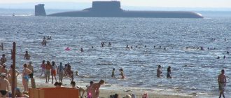
Derbent is a very interesting city from a historical perspective. It is located in the so-called Caspian Passage. This is the place where the Caucasus Mountains are closest to the Caspian Sea, leaving only a small strip of plain 3 kilometers wide. It is warm here, the average temperature is +13 degrees, there are a lot of sunny days throughout the year. This city is one of the largest in terms of population, it ranks second in the Republic of Dagestan after the capital - Makhachkala.
It is believed that this is one of the oldest cities in the world. Its history has been going on for 5 thousand years, although in modern times it is officially considered to be only 2 thousand years. There is controversy about this. In Soviet times, it was assumed that the city was founded 2,700 years ago, as it was mentioned in ancient sources of the 8th-7th centuries BC. This point of view would be considered official if traces of settlements of the Early Bronze Age had not been found here, and their age is precisely 5 thousand years. It is officially accepted that the city is only 2000 years old, however, even this figure is impressive.
The city's name is Persian and means "Closed Gate". It can be assumed that these gates were closed to the encroaching conquerors. In ancient sources, these places had a similar name - “Caspian Gate”. This city was a strategically important point; many sought to take it under their power. At one time, the Scythians visited here, as well as the Cimmerians, Sarmatians, Huns, Parthians, Khazars and Turks. The Romans and Greeks fought for the Caspian Gate. The city was at one time under the rule of Tamerlane. In 1813 it became part of the Russian Empire. Currently, 120 thousand people live in the city, it is gradually improving and developing.
see also
- Dagestan
- Symbols and sights of Dagestan
- Cities of Russia
| [ + ] Cities by regions of Russia | |
| Cities of the North-West (NWFD) | St. Petersburg (and its cities) • Leningrad region (historical Staraya Ladoga) • Arkhangelsk region • Vologda region • Kaliningrad region • Karelia • Komi • Murmansk region • Nenets Autonomous Okrug • Pskov region |
| Cities of the Volga region (Volga Federal District) | Bashkortostan • Volgograd region • Kalmykia • Kirov region • Mari El • Mordovia • Nizhny Novgorod region • Orenburg region • Penza region • Perm region • Samara region • Saratov region • Tatarstan • Udmurtia • Ulyanovsk region • Chuvashia |
| Cities of Southern Russia (SFD) | Sevastopol (including Inkerman) • Republic of Crimea • Adygea • Astrakhan region • Krasnodar region • Rostov region |
| Cities of the North Caucasus (NCFD) | Dagestan • Ingushetia • Kabardino-Balkaria • Karachay-Cherkessia • North Ossetia - Alania • Stavropol Territory • Chechen Republic |
| Cities of the Urals (Ural Federal District) | Kurgan region • Sverdlovsk region • Tyumen region • Khanty-Mansi Autonomous Okrug - Yugra • Chelyabinsk region • Yamalo-Nenets Autonomous Okrug |
| Cities of Siberia (Siberian Federal District) | Altai Republic • Altai Territory • Irkutsk Region • Kemerovo Region • Krasnoyarsk Region • Novgorod Region • Novosibirsk Region • Omsk Region • Tomsk Region • Tyva • Khakassia |
| Cities of the Far East (FEFD) | Amur Region • Buryatia • Jewish Autonomous Region • Trans-Baikal Territory • Kamchatka Territory • Magadan Region • Primorsky Territory • Sakha (Yakutia) • Sakhalin Region • Khabarovsk Territory • Chukotka Autonomous Region |
| see also | Cities of the DPR, LPR, Transnistria, South Ossetia • Regions of Russia • Cities of Russia |
Sights of Derbent
The main attraction of Derbent is its fortress walls. The Derbent fortress was built by the Persians in the 6th century under Shah Khosrow I. It was erected to protect against the Khazars and other nomadic peoples from the north. For construction, instead of the previous masonry, more reliable rough stone blocks were used.
The Naryn-Kala citadel is located on a hill 3 kilometers from the sea. Two walls stretch from it to the banks. In the east, the fortress wall rushes to the sea for almost half a kilometer. The Derbent fortress was included in the UNESCO list in 2003. Inside the fortress there is also a very ancient church, which miraculously survived from the 5th century.
The Juma Mosque is the main religious building of Derbent, and the whole of Dagestan. In addition, this is the oldest mosque in Russia; for a long time it was the only one in the southern part of Dagestan. Besides it, there are several other ancient mosques. These are the Minaret-mosque, Bala-mosque, Kirkhlyar-mosque.
The museums in the city may also be of interest. For example, the unusual Carpet Museum is located in an Armenian church. In Dagestan, carpets are still traditionally woven by hand; you can see beautiful ornaments and patterns on them.
Current statistics
As for official statistics, according to them, 3,110,858 people live in Dagestan. It is interesting that the number of citizens of Chechnya and Dagestan is constantly growing, which is due to several parameters.
Firstly, religious and national traditions, which determine the large number of children in families. Secondly, by improving conditions in terms of access to medical care, improving the quality of education and the development of certain industrial sectors, such as oil and gas production.
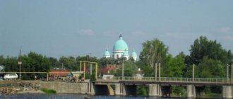
Dagestan Lights
This city got its name due to a very unusual phenomenon. As a result of the earthquake in 1904, gas emissions occurred here that looked like torches. Soon, small businesses began to open in these places. The settlement began to develop slowly; the official founding date was 1914. The settlement acquired urban status only in 1991.
Dagestan Lights is the youngest city in the republic; it is a satellite of Derbent. There is a glass factory here; Molotov cocktails were supplied from here during the war. Today it is the largest enterprise in the city.
Kizlyar
The official date of foundation of this city is 1735, but before that there was already a settlement here - there was an Arab fortress here. Then the Russians built a fortification here under the leadership of General-in-Chief Levashov, and a monument was erected in his honor in the city. And the history of the city dates back to those times. In the 18th-19th centuries it was a significant center of trade.
Today, agriculture is most developed here. The city became famous thanks to knives. Kizlyar knives are known all over the world; significant weapons factories are located in the city.
Izberbash
This city is also young, founded in 1932, although the archives contain information about the existence of an earlier settlement of Ulu-Izbar on this site. It is mentioned in the camp journal of Emperor Peter I, dated 1722.
Izberbash appeared thanks to the development of the oil industry here. Oil production takes place on the shelf of the Caspian Sea, the city itself is located on the coast 65 kilometers from the capital of the republic. It was built by oil workers and is recognized as the most comfortable in the country. In addition to oil production enterprises, there is a radio plant, a clothing factory, two confectionery factories, a city dairy factory, and a bakery. Nectars and juices are produced, and there is also wine and cognac. Notable is Mount Pushkin-Tau, whose outline resembles the profile of a famous classic.
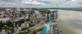
KASPIYSK
A city in the Russian Federation, the Republic of Dagestan, is located on the shores of the Caspian Sea, on the Primorskaya Lowland, near the foothills of the Greater Caucasus, 14 km from the Makhachkala railway station. Population 70.0 thousand people (2001). Founded in 1932. Until 1947, the village of Dvigatestroy. City since 1947.
Main industrial enterprises: (diesel engines for marine vessels), precision mechanics, stone processing, brick making. Factories: textile and haberdashery, "Universal". CHP. Animal husbandry.
It arose as a workers' settlement, Dvigatelstroy, during the construction of an engine plant.
Educational and cultural institutions: Faculty of Mechanics of Makhachkala Polytechnic Institute; local history museum; Museum of twice Hero of the Soviet Union test pilot S. Amet-Khan.
The peculiarities of knowledge-intensive machine-building and instrument-making production stimulated the development of our own scientific potential. Therefore, the design and technological department of the Leningrad Research Institute "Gidropribor" was created in Kaspiysk. The works of Caspian scientists - Academician of the Academy of Cosmonautics Sh. G. Aliyev, Doctors of Science M. M. Abacharaev, A. D. Amaev, G. S. Gamidov, Professor A. M. Amadziev - became widely known. There are over 20 candidates of sciences working in our city of engineers.
Since 1992, the plant has been in a landslide conversion zone. Initially, Yegor Gaidar’s government even raised the question of the so-called “zero option,” that is, a complete cessation of funding for the defense industry, but, thank God, it did not come to that. “At the top” they realized that instead of transferring the well-equipped factories of the military-industrial complex to the production of saucepans or sausage machines, it is much more profitable to leave them in their former quality and not give up their place in the global arms trade. Now there are all signs that Russia is beginning to restore its lost positions in this type of business, with which Dagdizel pins its hopes for the recovery and restoration of its main production.
The last few difficult years have again shown the best qualities of our people - patience, common sense, and the ability to maintain faith in the future. Thanks to them for this. The team survived also because it learned lessons from the conversion and prepared for it in advance since 1988. Suffice it to say that in recent years, Dagdizel has mastered the production of about thirty civilian products - from electric meat grinders and furniture to stone-cutting machines and pneumatic tools.
The situation now, of course, is very difficult, but there is light at the end of the tunnel, which can be considered the government’s understanding of the special role of the military-industrial complex in the country’s economy. And the plant itself, which recently became a joint-stock company, is increasingly adapting to market realities. So we look to the future with hope.
Buynaksk
One of the oldest cities in Dagestan. In its place, at the end of the 14th century, an aul arose, at the same time in 1386, the camp of Tamerlane’s army was located here. Almost 3.5 centuries later, in 1832, a Russian fortification was founded here with the former name Temir-Khan-Shura (Lake Tamerlane). This name remained until 1922. During the civil war, this settlement was the capital of the republic of the mountains. The modern name comes from the surname of the revolutionary Buinaksky. At the end of the twentieth century, sad events took place here, namely an earthquake in 1970 and a terrorist attack in 1999, when a residential building was blown up.
Currently, 64 thousand people live here, Buinaksk is multinational. It is included in the list of cities in Dagestan that belong to the central district. The nature in the vicinity of the city is very beautiful; the Shura-Ozen mountain river flows nearby. The climate is mild, so there are sanatoriums for tuberculosis patients here.