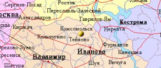
On the banks of the Volga stands one of many ancient Russian cities, preserving the memory of its centuries-old past. Yuryevets. Yes, another Russian city named after Prince Yuri. Today it is the regional center of the Ivanovo region, located 168 km northeast of Ivanovo. And before that - a medieval fortress city, which for five centuries defended the north-eastern borders of Rus'. Yuryevets is an old shopping center. It stands at the intersection of the Volga trade route and the Great Post Road from the center of Russia to Siberia.
What to see in Yuryevets - TOP places for one day
Three attractions of Yuryevets have become its calling card and attract the largest number of tourists to the city. About them below.
Andrei Tarkovsky Museum
- Address: st. Tarkovsky, 8.
The village of Zavrazhye in the vicinity of Yuryevets is the small homeland of the famous Soviet film director. Andrei Arsenievich’s parents lived in Moscow, but during pregnancy Tarkovskaya came to visit relatives in the Ivanovo region. The son of the famous poet was born in a small village near the Gorky Reservoir, then the family moved to the other side to Yuryevets.
Here, in a simple wooden house built in 1911, the first two years of little Andrei’s life passed. At that time it was a communal apartment in which several families lived, the rooms were divided between the residents.
The Tarkovskys owned two rooms. In 1996, a museum dedicated to the maestro opened in the house. The old things were not preserved, but the museum workers managed to restore the situation with the help of Marina Tarkovskaya, Andrei’s younger sister.
The street on which the building stands is also named after the master. The most valuable exhibit in the collection is the director’s personal archive, acquired in 2013 at a Sotheby’s auction. To buy the archive, I had to spend a huge amount of money. In addition to the house museum, there is a Tarkovsky Cultural Center in the town.
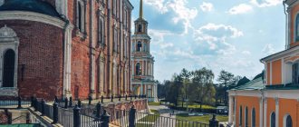
The bell tower of the martyr. St. George the Victorious
- Address: Sovetskaya st., 39.
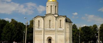
The stunning five-tier bell tower dwarfs all the buildings in the city with its height and scale. The delightful 70-meter tower has become a symbol of Yuryevets; it is the one that can most often be seen on postcards and other souvenirs. The structure was erected at the beginning of the 19th century; the building originally belonged to the Cathedral of the Entrance to Jerusalem. In 1840, a temple was built in the lower tier in honor of the Great Martyr George the Victorious.
In Soviet times, the Bolsheviks spared the magnificent bell tower and did not destroy it. In the 70s, the building required reconstruction. After the collapse of the USSR, the bell tower, along with other churches, was handed over to believers.
Today the structure is used not only for its intended purpose, but also as an observation deck. Tourists are allowed to climb to the middle tier to view the surrounding area. From a 40-meter height there is a stunning view of the city and the Volga. The bell tower and two neighboring churches form a single temple ensemble and are currently the courtyard of the Nikolo-Shartomsky Monastery.
Gorky Reservoir
- Coordinates on the map: 57.315940, 43.170115.
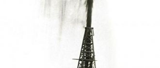
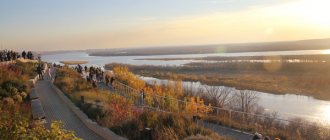
Yuryevets is located on the banks of the famous Gorky, or Nizhny Novgorod, reservoir. The endless reservoir, which covers the territories of four regions, is called the sea due to its enormous size. The reservoir began to be filled in 1955; water flooded a plot of land with an area of about 1,600 square meters. km. The widest part is located in the Yuryevets district; in some places the width of the artificial lake reaches 14 km.
Before the flooding, thousands of houses were moved from Yuryevets and other settlements. Temples that stood in the path of the water flow were simply destroyed. Today the reservoir has become a popular holiday destination. In hot weather, the beaches become especially crowded; Yuryevsk residents and tourists swim in the warm water and sunbathe on the sand. The reservoir is rich in fish, so it is popular with fishermen.
History gone underwater
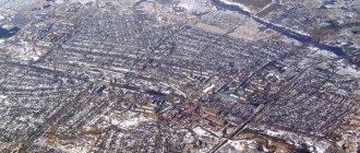
Yuryevets is considered the most ancient city in the Ivanovo region and one of the oldest in Russia. Spread freely on high hills, a chain approaching the narrow coastal edge, it is famous among the Volga cities for the beauty of its location.
Novaya Slobodka, Volzhskaya st.-1
Over its long history, the city has repeatedly and significantly changed its appearance. In the first centuries, the reason was the invasion of enemy hordes, which repeatedly burned it to the ground. The life and appearance of the city underwent significant changes in connection with the construction of the Gorky hydroelectric power station in 1953-1959, when part of the Yuryevets district found itself above water.
Today we are publishing a study prepared based on materials from the archival department of the administration of the Yuryevets municipal district, by students of secondary school No. 2 Ksenia Begunova and Natalya Stolbikova. In preparation, the girls also used materials on the history of secondary school No. 3 and the memories of residents.
— According to official data, until 1953, the width of the Volga bed averaged approximately 450 meters, the depth was 4-6 meters, in some places it reached 10, and on the rifts up to a meter. The width of today's Volga is 11-13 kilometers. So what was there before and turned out to be hidden under the blue surface of the “Gorky Sea”?
On November 16, 1947, the Council of Ministers of the USSR decided to build the Gorky hydroelectric power station in the Nizhny Novgorod region, then Gorky region. It was destined to become the next waterworks in the development of the Volga cascade. As a result, the Gorky Reservoir was to be formed. The flood zone included populated areas of the Chkalovsky, Puchezhsky, and Kineshma districts. But most of the territories that were supposed to go under water were the lands of the Yuryevets district.
Work on the resettlement of the Ivanovo flood zone began in the Yuryevets district in 1950, and this despite the fact that until February 1952 there was no apparatus to manage these works.
By decision of the Ivanovo Regional Executive Committee, 39,621 hectares of land were seized for the reservoir bed, including 26,687 hectares of collective farm lands (51 collective farms) and 13,004 hectares of other land users. In total, the territory is 22 village councils. In the Yuryevets district the following were subject to transfer: 214 houses in the city; 672 - from the village of Novaya Slobodka, 1315 - in rural areas, 383 other buildings and 8 churches. A total of 81 settlements.
There was a lot of work ahead. There were also 384 government institutions in the expected flood zone. Some were relocated to the Ivanovo region, others to the neighboring Kostroma region. Forest and village hospital - from Slobodka to Glazovaya Mountain. A wooden two-story high school - on Seletskoe field (now there are two-story houses in its place). Workshops “Krivoozersky Zaton” - in the village of Elnat (Alekseevka village). The central regional workshops and rafting office are in Gorchukha (Kostroma region). The Mayak state farm was partially withdrawn from the Ivanovo region.
From the village of Novaya Slobodka, the bakery moved to Yuryevets, the timber industry enterprise was abolished, and the sleeper plant was dismantled. Residential houses of private citizens, rafting offices and timber moved to Glazova Gora and to several houses in different places of the city.
As it turned out later, thousands of historical and cultural monuments were destroyed. Now the man-made sea splashes over the Trinity-Kalyazinsky, Leushinsky, Yugsky-Dorofeevsky, Mologsko-Afanasyevsky, Krivoezersky monasteries. In Isakov there was the Vozdvizhenskaya Church and an ancient cemetery near it, surrounded by a brick wall. There was a large, good school in Bukharin. The large vegetable-growing state farm "Mayak" also went under water. Everything was swallowed up by water, only to be washed away and turned into silt, which covers the bottom of this endless expanse of water.
3,907 families were subject to resettlement. Of these, 698 were in the city, 1,615 were in the village of Novaya Slobodka, and 1,594 were in rural areas. Cash compensation was awarded for resettlement. Those who lived in private apartments were given money to buy housing. Moreover, it was calculated differently. In total, the city issued 2,402,780 rubles 74 kopecks. In “Novaya Slobodka” - 6373734 rubles 33 kopecks, in rural areas - 17307536 rubles 00 kopecks, for public buildings in the village the amount of accrued compensation was 4896479 rubles 25 kopecks.
Tens of thousands of people, against their own will, were forced to leave their native villages, move away from places they had lived in for centuries, and change their life plans. As a result, some built houses for themselves and many left the Yuryevets district, including outside the Ivanovo region.
The grandiose plan to raise the Volga by 17 m so that the powerful turbines of the Gorky hydroelectric station would start working, plunged mainly the older generation into panic. The youth dismantled buildings, temples, enthusiastically worked on cutting down and uprooting forests in the bed of the reservoir (about 20 thousand hectares were cut down in the Yuryevets district alone) and eagerly awaited a miracle - the appearance of a “man-made” sea...
For the city, lands were alienated from the collective farm "Red Banner" of the Potemkin Village Council and lands belonging to the personal plots of collective farmers in the village of Karpushino, currently this is Karpushinskaya Street in the city of Yuryevets. This is how the Seletskoye Pole microdistrict appeared.
According to the original development project for Glazovaya Gora, the city’s residential area and institutions were to be located at the site of the current location of the DOK (now the Omega enterprise). But district and city organizations did not agree with this and, through the Ivanovo Regional Executive Committee, filed a petition to develop the allocated territory in reverse, i.e. as currently.
To carry out work related to resettlement from the flood zone, Avtokolonna (now a motor transport enterprise) and the construction organization Spetsstroy were created, which was engaged in the restoration of transferred objects in a new location and the construction of residential buildings and government institutions. The construction organization "Selstroy" carried out work of rural significance with resettlement and restoration in rural areas. OblzhilKomunstroy erected engineering structures in the city: a dam, pumping stations and diesel stations.
According to the project drawn up by Mosgidep, the entire lower terrace of the city of Yuryevets was supposed to move to the mountain. Old-timers wrote a letter addressed to Comrade Stalin with a request to leave the city in place and protect it with a dam. The initiators of this letter were more than 70 people: Gorodnichin, Zhilin, Chernogubov, Abrosimov and others. The cost of engineering structures in the city of Yuryevets amounted to more than 40 million rubles. The main workforce during its construction was women.
According to data from 1852, in the city of Yuryevets-Povolsky there were six monasteries and seventeen churches. During the construction of the Gorky Reservoir, many temples and monasteries in the city of Yuryevets were dismantled.
The Church of the Annunciation (market area), where bread bakeries were located, fell within the line of the dam. Initially, the temple was built as a valuable architectural monument in 1700 and was considered one of the most beautiful temples in the city. It contained frescoes that were of great importance in Russian architecture.
The building was planned to remain in place. On this occasion, various commissions came from Ivanovo and Moscow, including from the Main Architectural Directorate under the Council of Ministers of the USSR. The preservation of the temple was refused.
When dismantling the temple, a unique 12-tier iconostasis was discovered under a layer of plaster. The frescoes and some of the tiles were mounted into the walls of the former local history museum (Church of the Epiphany), and the other part was sent to museums across the country, including the Andrei Rublev Museum in Fili in Moscow.
The bed of the Gorky Reservoir was filled with water in 1954-57...
Memoirs of G. A. Smirnova, a resident of the village of Novaya Slobodka.
I was born in the village of Novaya Slobodka in 1938. Our village was large, the entire population worked as sleepers and watermen, where barges and small vessels were stopped for repairs in the winter. All kinds of repair work were carried out in the central repair shops, and there was also a state farm where peat was extracted from the swamp. It had its own outpatient clinic and maternity ward. And wonderful people worked everywhere.
In two schools they studied from 1st to 4th grade and from fifth to tenth. One of the buildings was called the Polish school. During the war, Polish children were brought to Novaya Slobodka, and they lived and studied there. There were 2 clubs, one of which was located in the premises of a former monastery.
And there’s no need to talk about the beauty of nature. There were three lakes, they were called Black, Krivoe and Staygosh. Mushrooms and berries grew. When they started talking about flooding and relocation, many did not believe it and were very worried. When we moved, we received a “lift” and an interest-free loan.
The bulk of Slobodka residents moved to Glazovaya Mountain. Many left for Balakhna, Kineshma, and Gorchukha. Life was hard. We had no workers, my grandfather was old, my grandmother and mother, there were two of us - I was 16 years old and my brother was 13 years old. He and I went rafting to Gorchukha and everything began to improve. They transported us by ferry. They worked as helpers at a construction site, covering the roof with shingles. Grandfather guided us from the ground, and we crawled on the roof. Then the Red Profintern started working, and we went to work there. But if they said that you could return to Slobodka to live, I’m sure many would do it.
In the 90s, the churches located in the center of Yuryevets were transferred to the courtyard of the St. Nicholas Shartomsky Monastery. Monks in the middle of the Volga, on the spot where the Krivoezersky Monastery once stood, with the help of a number of organizations and sponsors, erected a cross. And now everyone who comes to Yuryevets or simply passes on a ship along the Volga involuntarily pays attention to this unique monument. The cross burns in the sun like a candle, symbolizing human memory, reminding of all those who have passed on, and in health and in gratitude to all those living.
The material was prepared for publication by M. Krainov
The most interesting museums in the city of Yuryevets
The variety of Yuryevets museums will delight history buffs and fans of the work of Andrei Tarkovsky.
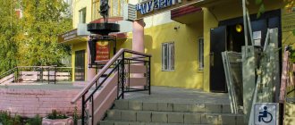
Historical and Art Museum
- Address: st. Tarkovsky, 2.
The Yuryevets Central Museum was founded in 1920 as a branch of the local history museum. Currently, the institution occupies a two-story red brick building, decorated with a small multifaceted turret. There are several halls inside, each of which is dedicated to a specific era or event in the history of the city.
The first hall tells about the medieval period, when a fortress stood on the site of the modern city. The second tells about the exploits of Yuryev residents during the Great Patriotic War. The third is dedicated to the spiritual life of townspeople, local churches and monasteries.
Museum of Architects Vesnin
- Address: Vesninykh entrance, 8.
The Vesnins created many well-known objects throughout the country, including the Dnieper Hydroelectric Power Station and the department store on Krasnaya Presnya. Three brothers were born into a merchant family, received a good education and found their calling in architecture. The peak of their creative activity occurred in the 1920s.
The museum, dedicated to the famous residents of Yuryev, is located in the original house in which the brothers-architects were born and raised. The building is made of red brick and stands on a hillside; a wooden roof decorated with fine carvings is built over the porch. A museum exhibition opened in the house in 1986.
Cultural Center named after. A. Tarkovsky
- Address: Sovetskaya st., 33.
The Tarkovsky Center is the Yuryevets citadel of cinema. The spacious two-story building, built in 2011, houses a film school and regularly hosts various film festivals, including the International Film Festival, named after the outstanding director.
The premises are divided into halls, in one there are film shows, in the other the archives of Andrei Arsenievich are stored, in the third there is a library in which various editions of Tarkovsky Sr.’s books are collected.
Museum of Public Education
- Address: Sovetskaya st., 143.
Another wonderful museum was organized in 1996 by former teacher and school director A.V. Sirotina. The museum is housed in an old wooden mansion. With the help of exhibitions, you can trace the history of education in the city and region, from the first public schools to the present day.
Visitors will learn how classrooms were equipped before the revolution, what past generations of teachers and students looked like, and what objects they used during classes. Also, museum guests will be told about the school years of famous Yuryev residents: singer V. Leontyev, artist U. Potapenko, heart surgeon B. Lastochkin and others.
Exhibition Hall "Georgievsky"
- Address: st. Tarkovsky, 1a.
The exhibition hall was first presented to the public in 1977; initially the gallery was located in the bell tower of the Cathedral of the Entry of the Lord into Jerusalem. In 2004, the exhibition moved to the interesting asymmetrical administration building.
The art gallery occupies the first floor of the building. The exhibitions feature paintings by local painters, including both professionals and amateurs. A significant part of the collection consists of works by students of the local art school.
Theater-Museum "Istoki"
- Address: st. Nakhimova, 35A.
The building of the Yuryevets Technical School houses a unique puppet theater-museum. Its history dates back to 1996, when local craftswoman Tatyana Ulitova decided to present her works to the general public.
The museum's collection includes traditional folk and more modern dolls, as well as three-dimensional portraits, painted bottles and other objects created by the owner of the private museum and her students.
Some of the attraction's exhibits depict famous people and literary characters. For an additional fee, you can try on costumes of different nations and attend a master class on creating dolls.
Yuryevets
(Ivanovo region)
OKATO code:
24237501
Founded:
1225
City from:
1225 City of district subordination (Yuryevetsky district, Ivanovo region)
Center:
Yuryevetsky district
Telephone code (reference phone)
| 49337***** | 23-0-53 |
Deviation from Moscow time, hours:
0
Geographic latitude:
57°19′
Geographic longitude:
43°06′
Altitude above sea level, meters:
120 Sunrise and sunset times in the city of Yuryevets
Beautiful temples and churches of Yuryevets
In almost every district of Yuryevets you can see an ancient Orthodox church. Religious buildings are one of the main assets of the city.
Cathedral of the Entry of the Lord into Jerusalem
- Address: Sovetskaya st., 41.
The Winter Church of the Entrance to Jerusalem was built around 1733. In 1806, the chapel of St. John the Warrior was added to the church building. After the October Revolution, the temple was beheaded and turned into a warehouse.
In the 80s, the building began to be restored, but was finally handed over to believers only in 1997. After the solemn consecration, services resumed in the church. Nowadays, the cathedral has the status of a metochion of the Nikolo-Shartom monastery.
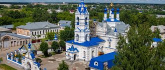
Cathedral of the Assumption of the Blessed Virgin Mary
- Address: Sovetskaya st., 43.
The Assumption Cathedral on the central square forms a single architectural complex with the Cathedral of the Entrance to Jerusalem and the Bell Tower of St. George. Unlike its warm neighbor, the Church of the Assumption was intended for summer services.
The monumental classical cathedral was once one of the best buildings in the city, but after persecution in the 20th century it is in deplorable condition.
The shabby square building is adjoined by vestibules with porticoes and columns; in place of the destroyed upper tier there is now a gray roof topped with a tiny dome. Reconstruction is proceeding slowly, since the huge structure requires equally huge costs.
Church of the Nativity
- Address: Sovetskaya st., 47.
A small ancient temple from the 19th century adorns the central street of the city. The building was erected in 1815 in memory of the victory in the Patriotic War of 1812. According to legend, the temple was built by captured Frenchmen. The church was built in the style of classicism with baroque elements. A single dome crowns the roof of the church.
The original paintings have been preserved inside; a high worship cross has been installed opposite the entrance.
Previously, a low bell tower adjoined the temple. After the Revolution, the upper tiers of the bell tower were destroyed, and an archive was placed in the church itself. After the collapse of the Soviet Union, the building was returned to Orthodox Christians. Like many other places of worship in Yuryevets, the Church of the Nativity has the status of a courtyard of the Nikolo-Shartomsky Monastery.
Epiphany Church
- Address: per. Engelsa, 10.
The Church of the Epiphany is one of the most beautiful and oldest in the city and region. The five-domed temple rises on Simonova Mountain. The brick building was erected in the first half of the 18th century; a hundred years later a bell tower was added to the church.
The building has its own unusual “zest”: within its walls there are parts of other churches. It is believed that during the work the builders used materials from the old stone temples of the city. In addition to the main chapel, chapels of St. Macarius of Unzhensk and the Apostle Simon the Canaanite were built in the temple.
During the Soviet years, services ceased; government officials ordered the domes to be destroyed and the building transferred to a local history museum.
In 1955, parts of the temples destroyed during the creation of the Gorky Reservoir became part of the Church of the Epiphany. The unusual decor completely changed the appearance of the ancient building. In 1989, the building was returned to the Russian Orthodox Church and gradually restored.
Temple of the Holy Spirit
- Address: st. Herzen, 1A.
A remarkable single-domed church with a bell tower was built at the city cemetery in 1839. Yuryevets merchant Ivan Polyakov donated money for the construction. During the Soviet years, the Church of the Holy Spirit not only did not close, but even expanded.
In the 50s, chapels were added to the church, and 30 years later a semi-circular apse was added. Rare bas-relief icons from the 19th century have been preserved inside.
Sretenskaya Church
- Address: Krasnougolny lane, 1.
A small stone church, built in 1757, is all that remains of the ancient Sretensky Convent. The monastery was abolished in 1764, and the church became a parish. The temple has two chapels: the Presentation of the Lord and St. John Chrysostom.
During Soviet times, the building suffered greatly at the hands of the communists: adherents of the new government destroyed the dome and the beautiful hipped bell tower and placed a brewery inside the desecrated temple.
In the 90s, the plant ceased to exist, and the former church was abandoned to its fate. At the end of the 2000s, the dilapidated building was handed over to the Russian Orthodox Church; restoration work continues to this day.
Volga from source to mouth. Yuryevets.
Yuryevets has a long and glorious history. It was founded at the confluence of three rivers - the Volga, Unzha and Nemda.
According to the most common version, the city was founded by the Vladimir prince Yuri (George) Vsevolodich as Yuryev-Povolsky and named after him (another name is Georgievsk).
According to legend, the Grand Duke of Vladimir Yuri Vsevolodovich, son of Vsevolod the Big Nest, returning from his nephews, the sons of his late brother Konstantin, stopped to rest at the mouth of the Unzha River, the left tributary of the Volga.
While sleeping, he had a vision: on the opposite bank, among an impenetrable thicket, there was a mountain, and on it was an icon of St. George the Victorious, in front of which a candle was burning. Having woken up, the Grand Duke ordered to go down the Volga and, approaching the creek, now called Yuryeva, he began to carefully look at the other bank of the Volga. The prince suddenly saw a fiery ray like a shining star breaking through from an unknown mountain, through the thicket of the forest. The prince with his boyar Vasily, nicknamed Skorumny, and his retinue crossed to the right bank of the Volga. There, in a dark forest, on a steep mountain, he allegedly found a miraculous icon, in front of which a candle burned in a dream. In memory of the event, the mountain began to be called St. George, and the icon, according to the chronicle, written on a board with spherical outlines, was subsequently transferred to the Moscow Assumption Cathedral.
Another legend says that the icon was carved on stone. At the site where the icon was found, the prince ordered the construction of a wooden city, calling it by his name and in honor of the saint of God Georgievsky or Yuryev-Povolsky (Povolzhsky).
According to the second version, the city was founded by Prince Yuri in 1150. In the “Selected Works” of V. N. Tatishchev, where his notes were first published during the preparation of “Russian History”, in many chronicles and documents that have not reached us, it is stated that “a town on the Volga in White Rus' is also named Yuryev, built by Yury or George II in 1150, now called Yuryev Povolsky, or Yuryevets, which is in the province of Nizhny Novgorod on the right bank of the river above Bolokhny 90 and below Kineshma 60 versts.”
The first Yuryevets fortress stood on St. George's Mountain. High walls were erected on earthen ramparts surrounded by ditches. All that is known about the fortress is that it was originally built of wood. It becomes clear that the fortress was often destroyed in fires, although each time after them it was restored in its place. In the 17th century, when the city was devastated by the army of Pan Lisovsky, the “White City” was built not in its place, but on the nearby Simonovskaya Mountain.
Yurievetsky Zemlyanye Vals
Unfortunately, it has not survived to this day - it was demolished for the construction of a protective dam on the banks of the Volga. Now in Yuryevets you can see the preserved ramparts and ditches of his last fortress - the White City.
The White City is considered one of the rare monuments of Russian military engineering art.
Yurievetsky Posad was located under the mountain, on the banks of the Volga. It occupied the territory that is now located between the river port and the former post office building. It was surrounded on all sides by monasteries, which, along with fortresses, were part of the defense system of the ancient city.
In 1237, Yuryevets was burned by the hordes of Batu. This past left its mark on the etymology of many city names. Gunners lived on Mount Pushkarikhe, and from the high Glazovaya Mountain they “looked” to see if the Tatars were coming from the lower reaches of the Volga.
In 1380, Yuryevets warriors fought bravely on the Kulikovo field in the regiments of their prince Vladimir Andreevich Gorodetsky-Serpukhovsky, cousin of Dmitry Donskoy. Since 1405, Yuryevets was part of the Gorodets principality, from 1448 - the Moscow principality, and from 1451 - the Suzdal principality, then again - the Moscow principality. In 1536-1537 the city was plundered by the Kazan Tatars. And in 1556 he was discharged by Ivan IV to the oprichnina.
At the beginning of the 17th century, during the period of the Polish-Lithuanian intervention, Yuryevets was repeatedly attacked by the Poles. In 1609, the local centurion Fyodor the Red led the local militia, which liberated Lukh, Shuya, and Kineshma. In response, the famous Pan Lisovsky burned the city, but the residents of the surrounding area bravely fought off his fighters, and help that came to them from Nizhny Novgorod along the Volga saved the situation. The townspeople joined the troops of Pozharsky and Minin passing through the city, but the liberation of Moscow in 1612 did not bring the desired stability. In 1614, the Cossacks of Ivan Zarutsky again plundered and burned Yuryevets, although they were later defeated by the governor Boris Lykov.
At the end of the 18th century, Yuryevets became a district town in the Kostroma province. Free by nature, Yuryevites engage in seasonal work: they go to barge haulers, rafting and sawing timber. Yuryevets becomes one of the barge hauler centers on the Volga with its “Fried Hillock” - the place for traditional rites of initiation into barge haulers. The Volga connects all of Russia, from the Baltic to the Caspian. Up the Unzha from Yuryevets the ancient path “beyond the Stone” began - to the Urals and beyond. Yuryev local historians are confident that Ermak Timofeevich is their fellow countryman. His grandfather, an old robber, was allegedly hiding from detectives in Yuryevets, and after his grandfather’s death, his grandson set off to conquer Siberia.
In the era of Peter I, when the administrative division of the country into provinces was introduced, Yuryevets became part of the Kazan province from 1708.
City status since 1778. For the city's services to the country, on March 29, 1779, Catherine II granted Yuryevets a personalized coat of arms: despite the fact that it is not a provincial center, the heraldic shield contains only the symbol of the city, without the provincial coat of arms.
The coat of arms of Yuryevets is a silver watchtower on a blue field. In some images of the coat of arms, instead of an abstract tower, a local landmark is drawn - a five-tiered bell tower.
At the turn of the 19th and 20th centuries, Yuryevets was not much different from other provincial Russian cities. Some of the crafts and trades of Yuryev residents have traditionally been associated with the Volga. The port city owes its worthy reputation to the skill and hard work of river workers, shipbuilders, fish catchers, and carriers.
Already in 1795 the city had a regular layout with a main square. The mayor's house, city administration, treasury, and Epiphany Church of the early 18th century were built; later, in the very center - the ensemble of the old (1806) and new (1825-1833) Cathedrals of the Entrance to Jerusalem, the Church of the Nativity (1815).
Assumption and Entrance to Jerusalem Cathedrals
The main architectural complex of the city is located at the intersection of the main street and the shopping area - the Assumption and Entrance of Jerusalem Cathedrals with a bell tower. The ensemble of cathedrals was erected in 1733 and rebuilt in 1806 by the provincial architect N.I. Metlin.
Bell tower of the Cathedral of the Entrance to Jerusalem in Yuryevets
In the central part of Yuryevets there is a remarkable Church of the Nativity of Christ, which faces the main street with its facade. The construction of the church took place in 1815, but already in the middle of the 19th century
The Church of the Epiphany, which is the oldest building of the surviving architectural monuments.
In the Temple are the relics of Blessed Simon Yurievetsky, the Fool for Christ's sake.
Church of the Holy Spirit
It was built in the middle of the cemetery in the first half of the 19th century at the expense of the merchant Ivan Polyakov. Services in the church were conducted even during the times of militant atheism, without interruption during the twentieth century.
Sretenskaya Church
Monastery church, which was erected on the banks of the Volga. In the 20th century, the church bell tower was destroyed, and the temple premises were given over to a brewery warehouse. Today the temple is gradually being restored.
In Yuryevets you often come across the name of Tarkovsky
Andrei Tarkovsky Museum Center
The museum is opened in the house where the Tarkovsky family lived.
Cultural Center named after A.A. Tarkovsky
This is a modern cinema center. It hosts a film school and hosts creative meetings and festivals.
The building was built in 1903. During the war there was an elementary school here, where Tarkovsky studied.
Streets and buildings
Vesnin Museum
The museum was opened in 1980 in the Vesnins’ family nest. Paintings, documents and photographs from personal archives, projects of three famous architect brothers of the 1920s are stored here.
Cherkassky House
Mikhail Nikolaevich Cherkassky was a zemstvo construction technician. Under his leadership, many buildings were built in the city. He remodeled an existing building for his family. The Cherkassky family nest is a residential building with a mezzanine. Its appearance has classical features, elements of folk architecture and Art Nouveau style. The building is decorated with wood carvings. The mansion adorns the main street of Yuryevets; now it houses a local history museum.
Theater-Museum "Istoki"
This is a kind of museum of dolls and unusual arts. The dolls are made in the shape of literary characters. It is here that you can see familiar images performed by local craftsmen using folk techniques.
And of course, Volga
A 12-meter-high worship Cross 2 kilometers from the shore commemorates the Krivozersky monastery hidden by the Volga waters, which fell into the flood zone. The monastery was preserved only in Levitan’s paintings, the famous “Evening Bells” and “Quiet Abode”
Painting Quiet Abode
Isaac Levitan "Evening Bells".
And where would we be without this beauty...
GOOD LUCK !!!
Natural attractions in the vicinity of Yuryevets
The flora and fauna of the Yuryevets district deserve special attention; some natural monuments are unique.
"Nagornaya Dacha"
- GPS coordinates: 57.315540, 43.073549.
Yuryevets is located in a surprisingly picturesque place: the city stands on high hills, a sea-like reservoir splashes in the east, and a forest rustles on the western side. The dense coniferous forest was named “Nagornaya Dacha” and has the status of a natural monument.
The total area of the protected area is 635 hectares. Most of the trees in Dacha are pine and spruce; the age of some specimens has crossed the hundred-year mark, and some centenarians are approaching their 200th anniversary.
In addition to them, there are cedars, oaks, larches, aspens, maples, lindens, poplars and other trees on the territory. The forest is home to many wild animals, birds and insects, and dozens of species of mushrooms, berries and medicinal herbs grow.
Mount Asaph
- Coordinates: 57.290816, 43.159576.
The natural monument, also called Osapovy Gory, is located near the city in the middle of the Gorky Reservoir. Seeing five pieces of land jutting out of the water, visitors to the area wonder: why are they called mountains? These are islands! Paradoxically, the mountains of Asaph really are mountains, or, more precisely, they were.
The hills reached tens of meters above the ground until the reservoir was created. The Volga flooded the land around the mountains, leaving only the forested tops sticking out of the water.
The resulting islands became a nesting center for waterfowl and a popular vacation spot among area residents and visitors from other regions. There are also small fish-rich lakes here. Tourists come to the Asaph Mountains to swim, sunbathe on sandy beaches, enjoy the scent of pine trees and go fishing.
Key of Simon the Blessed
- Coordinates: 57.349551, 42.772414.
Blessed Simon Yurievetsky lived back in the 16th century. In his youth, Simon left his parents' home, choosing the path of foolishness for Christ's sake. One day, the local governor Fyodor Petelin was angry with the holy fool and ordered his servants to beat him. It is believed that the servants overtook the saint near the village of Mikhailovka near a spring that he himself had dug. Simon could not stand the torture and died.
Even during his lifetime, the Holy Fool was considered a saint, so the place of his death began to be revered as a shrine. Several years ago, the inhabitants of the Nikolo-Shartom monastery erected a cross here and equipped a holy spring. A bathhouse and a wooden chapel were built above the spring, and a covered plank bridge leads to the church. Pilgrims from different regions of the country come to the spring of St. Simon.
City monuments of architecture and archeology
Almost every historical era has left its architectural heritage in Yuryevets.
"White City"
- Coordinates: 57.306718, 43.103027.
Ruins, ramparts and ditches are traces of the “youngest” fortress of Yuryevets, built in the second half of the 17th century. The construction of the walls was never completed, and the fortress began to collapse even before it was finished.
Local residents say that under the fortress there were underground passages and torture chambers in which the remains of people tortured to death were found. The archaeological monument is protected by the state, as indicated by a sign near the earthen ramparts.
Shopping arcades
- Address: Georgievskaya Square.
Trading shops, or shopping arcades, are located in the central square of the city next to the complex of the Assumption and Entry of Jerusalem Cathedrals. Shopping arcades are an entire architectural ensemble of several buildings, built at different times in different architectural styles.
All buildings are one-story, but some have low ceilings, while others are two floors high. Shopping arcades occupied a significant part of the city, which indicates the importance of trade in the life of Yuryevets.
Gymnasium named after A.S. Pushkin
- Address: Sovetskaya st., 102.
The education system has been developing in Yuryevets for a long time. At the end of the 19th century, wealthy townspeople built a girls' gymnasium at their own expense. The educational institution was opened on June 6, the birthday of Alexander Sergeevich Pushkin, so the gymnasium received the name of the great poet. The school became one of the first such institutions in the Russian Empire and in terms of education was almost as good as the best of them.
In addition to classrooms, the red brick building housed a library and the Church of the Theodore Icon of the Mother of God.
During Soviet times, the gymnasium was reformed into a comprehensive school, which is still in operation today. Teachers and students are proud that their school has such noble origins and venerable age, and have organized a small museum dedicated to its history. Relatively recently, a monument dedicated to teachers and students who died during the Great Patriotic War appeared near the gymnasium.
Cherkassky House
- Address: Sovetskaya st., 90.
Mikhail Cherkassky is an important person in the history of Yuryevets. Mikhail Nikolaevich worked as a builder and participated in the construction of many city buildings. The Cherkasskys purchased a small house in the city center, and the head of the family rebuilt the building to his own taste with his own hands. In 1990, reconstruction of the building began, and in 1996 the building housed a local history museum, which became a tourist attraction.
A one-story wooden house immediately catches your eye thanks to its unusual architecture and beautiful facade decor. Under the roof itself, elegant carved patterns in the form of outlandish flowers have been preserved. The most interesting element of the wooden painting is the image of a mermaid holding in her hand a sign with the inscription in Old Church Slavonic “I am the wife of Pharaoh.” The meaning of this inscription still remains a mystery even to the residents of Yuryev themselves.
Gorokhov's House
- Address: Sovetskaya st., 34.
Not far from the Cherkassky house there is the house of another famous Yuryev resident - Gorokhov. The mansion is a symmetrical brick building on two floors with beautiful arched windows; the facade of the building is richly decorated. Nearby there are brick outbuildings in the same style.
The house was built at the end of the 19th century, initially living rooms were located on the second floor, while trade took place on the first floor. After 1917, the house was nationalized. Currently, the mansion houses a police station.
Famous monuments and sculptures of Yuryevets
Yurievets witnessed and participated in many significant turns in the history of the country. The townspeople immortalized the memory of some events in stone and bronze.
Memorial cross
- Coordinates on the map: 57.313912, 43.146511.
Near Yuryevets, among the endless expanses of the reservoir, an amazing shrine is hidden - the Krivoezersky Monastery. The uniqueness of the attraction lies in the fact that it has not existed for a long time. The remains of the monastery were buried under tons of water when the reservoir was flooded.
Trinity Krivoezersky Monastery was founded in the 17th century. In the 18th and 19th centuries, the first stone buildings appeared on the territory. In the 1930s, the monastery was closed and turned into a prison and then a factory. 20 years later, when the plan to fill the reservoir was approved, all the buildings were dismantled to the ground.
Today, on the site of the monastery there is a huge 12-meter worship cross. The monument was erected in 2000 by the inhabitants of the Nikolo-Shartomsky monastery. The cross rises on the shallows directly opposite the St. George's Bell Tower. The monument is dedicated not only to the Krivoyezersk monastery, but also to all the churches destroyed in the city during the Soviet years.
Victory Square
- Address: 25th October Street.
Victory Square is located near the embankment of the Gorky Reservoir. It is here that you can see the main monuments dedicated to the participants of the Great Patriotic War. At the edge of the park, a 12-meter obelisk rises into the sky in memory of fallen soldiers.
A huge sword is carved on a gray slab - a symbol of the struggle for the native land. On both sides of the obelisk there are snow-white stones with memorable inscriptions. Two paths lead to the monument; between them stretches a row of black slabs with the names of Yuryevsk Heroes of the Soviet Union. There is also a monument to internationalist soldiers in the park.
Monuments to militias
- Address: s. Nikola-Elnat, Yuryevetsky district.
During the Time of Troubles, Yuryevets became one of the centers of the people's militia. In 1609-1612, volunteers gathered in the city and surrounding villages to fight the Polish invaders.
In the village of Nikola-Elnat several years ago, a memorial stone was erected in honor of local residents who participated in the militia. Attached to a large boulder is a marble plaque with an image of a cross and a dedication to the villagers.
In the regional center there is also a monument to heroes; it is a granite boulder, on one side of which hangs a sign with the image of Minin and Pozharsky and a short story about the detachment of Yuryevites. Recently, a large metal cross was installed on the stone.
White City
The White City was located on a mountain overlooking the river port. This is one of the most picturesque corners of Yuryevets with mighty pine trees and quiet ponds. The White City is considered one of the rare monuments of Russian military engineering art. Behind its walls, under the mountain, on the banks of the Volga, there was a settlement. It occupied the area that is now located between the port and the former post office building. It was surrounded on all sides by monasteries, which together with the fortress were part of the city’s defense system.
In 1237, Yuryevets was burned by the hordes of Batu. This past is reflected in many city names. Gunners lived on Mount Pushkarikhe, and from the high Glazovaya Mountain they “looked” to see if the Tatars were coming from the lower reaches of the Volga. In 1380, Yuryevets warriors fought on the Kulikovo field in the regiments of their prince Vladimir Andreevich Gorodetsky-Serpukhovsky, cousin of Dmitry Donskoy. Since 1405, Yuryevets was part of the Gorodets principality, from 1448 - the Moscow principality, and from 1451 - the Suzdal principality, then again - the Moscow principality. In 1536-1537 the city was plundered by the Kazan Tatars. And in 1556 Ivan IV assigned him to the oprichnina.
Architecture of the old city
At the beginning of the 17th century, during the period of the Polish-Lithuanian intervention, Yuryevets was repeatedly attacked by the Poles. In 1609, the local centurion Fyodor the Red led the local militia that liberated Lukh, Shuya, and Kineshma. The famous Pan Lisovsky burned the city, but the residents of the surrounding area bravely fought off his fighters, and help that came to them from Nizhny Novgorod along the Volga saved the situation. The townspeople joined the troops of Pozharsky and Minin passing through the city. But the liberation of Moscow in 1612 did not bring the desired stability. In 1614, the Cossacks of Ivan Zarutsky again plundered and burned Yuryevets, although they were later defeated by the governor Boris Lykov.