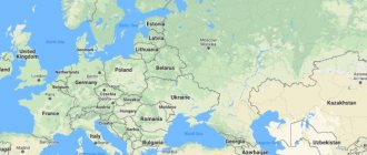
The Rostov region is located in the southern part of the East European Plain and partly in the North Caucasus region, occupying a vast territory in the Lower Don river basin. The area of the region is 100.9 thousand km² (0.6% of the territory of Russia). It could accommodate Belgium, Holland and Denmark combined. The length of the region is 470 km from north to south, 455 km from west to east.
In the west, the border of the Rostov region coincides with the state border of the Russian Federation with the Republic of Ukraine, including the maritime border in the Taganrog Bay of the Sea of Azov. In general, the length of the border of the Rostov region with Ukraine is about 700 km. Currently there are 22 customs checkpoints here.
In the north, east and south, the Rostov region borders on the constituent entities of the Russian Federation - the Voronezh and Volgograd regions, the Republic of Kalmykia, the Stavropol and Krasnodar territories.
The region is located within the North Caucasus economic region of Russia. Its immediate surroundings are represented by highly developed economically regions: Donbass in the west, Central Russia in the north, the Volga region in the east and the Caucasus in the south. Within a radius of 1.0 - 1.5 thousand km from the borders of the Rostov region are the country's largest coal, oil, gas, metallurgical, engineering, chemical, agro-industrial regions and centers.
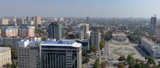
The Rostov region includes 463 municipalities, consisting of 12 urban districts, 43 municipal districts, 18 urban settlements and 390 rural settlements. The administrative center of the Rostov region is the city of Rostov-on-Don with a population of over 1 million people, a large industrial, cultural and scientific center. In 2002, the city acquired additional political and economic importance as the capital of the Southern Federal District. The distance from Rostov-on-Don to Moscow is 1226 km.
The major cities of the region are Taganrog (population 281 thousand people), Shakhty (245.5 thousand people), Novocherkassk (173.3 thousand people), Volgodonsk (169.6 thousand people) and Novoshakhtinsk (113 ,6 thousand people), Bataysk (104.8 thousand people).
Center coordinates.
We determine the geographic center of our region in geography lessons in 8th grade. It's very easy to do! To do this, you need to know the coordinates of the extreme points of the territory. In the Rostov region they are as follows:
The extreme northern point is located in the Verkhnedonsky region and has coordinates - 50.13, N.Sh.
The southernmost point is located in the Peschanokopsky district and has coordinates - 45.57, N.Sh.
The westernmost point is located in the Matveevo-Kurgan region and has coordinates - 38.14, E.D.
The easternmost point is located in the Zavetinsky district and has coordinates - 44.20, E.D.
To determine the geographic center, you need to calculate latitude and longitude.
50.13,+45.57,= 96.10,
96.10,: 2 = 48.05 (this is the latitude of the geographic center)
38.14,+ 44.20 = 82.34,
82.34, : 2 = 41.17, (this is the longitude of the geographic center)
Thus, the coordinates of the geographic center are 48.05, N.Sh., 41.17, E.D.
Brief description of the Rostov region
The Rostov region is a subject of the Russian Federation in the south of the European part of Russia, part of the Southern Federal District.
The Rostov region, as an administrative unit, was formed on the basis of a resolution of the Central Executive Committee of the USSR dated September 13, 1937.
Among other large territorial entities of the Russian Federation, the region stands out for its high scientific, production, resource and financial potential.
The development of the region's economy is based on the influence of such factors as a favorable economic and geographical position (connection of the center of Russia with the North Caucasus and Transcaucasia), the presence of natural resources, historically favorable development conditions, a high supply of labor resources, and a well-developed transport infrastructure. In terms of the pace of economic transformation in recent years and the volume of output of goods and services, the region occupies one of the leading positions both in the Southern Federal District and in Russia as a whole.
The immediate surroundings of the region are represented by the regions of Western Donbass, which have large reserves of natural resources, as well as the highly economically developed regions of the central part of Russia in the north, the Volga region in the east and the North Caucasus in the south.
Within a radius of 1.0-1.5 thousand km from the borders of the Rostov region there are the country's largest coal, oil, gas, metallurgical, engineering, chemical, agro-industrial areas and centers, the exchange of finished products of which is carried out, to a large extent, through the territory of the Rostov region. areas.
The Don, one of the largest rivers in Europe, with numerous branches and tributaries, flows through the region.
Mineral raw materials include a group of fuel and energy resources. Among them are coals from Eastern Donbass, especially anthracite, which is the best in the world in terms of caloric content.
Deposits of nonmetallic raw materials for metallurgy and the production of building materials are being developed. Explored gas reserves are estimated at 56.2 billion cubic meters.
The forest fund of the region is insignificant, represented on 2.8% of the territory, mostly by forests that perform water protection and protective functions.
Recreational resources are represented by local resorts for summer holidays with reserves of high-quality mineral waters, as well as ample opportunities for the development of international tourism.
Geographical location of the Center.
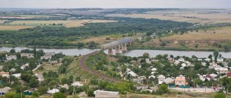
The geographical center of the Rostov region is located on the territory of the Tatsinsky district. Nearby are the villages: Isaev, Fominka, the village of Ermakovskaya - Tatsinsky district and the village of Yasnov - Belokalitvinsky district. The figure shows that the geographical center is located, practically, on the border of these two territories. If we calculate the straight line distance to the administrative centers, we get the following results: to Belaya Kalitva - about 35 kilometers, to Tatsinskaya - about 25 kilometers. Therefore, the route to the geographical center should be considered in the territory of two regions.
48.05, 41.17, Geographical center of the Rostov region.
National composition
In this area you can meet representatives of more than 40 ethnic groups. According to surveys, 90.3% consider themselves Russian. 2.64% are Armenians. Basically they are not migrants of the post-Soviet period. The Armenian diaspora appeared here several centuries ago. The community in Rostov-on-Don is especially close-knit. And in some cities of regional subordination, representatives of the Armenian ethnic group make up the majority in terms of population. The common border with Ukraine explains a fairly significant share (up to 4% according to population surveys) of Ukrainians.
2010 data
The territory is inhabited by Azerbaijanis, Turks, Gypsies, Moldovans, Germans, Jews, Tatars, Belarusians, Bashkirs, Poles, Greeks and representatives of Caucasian ethnic groups. These communities appeared in a number of cities and towns in the Rostov region in the 16th – 18th centuries. Diasporas celebrate holidays, there are national educational and cultural institutions.
The ethnic diversity of the Rostov region is reflected in the names. Examples include Nakhichevan-on-Don (now one of the districts of the regional center), Millerovo and other toponyms. The Don Cossacks are a special socio-ethnic community. According to various estimates, up to 30% of the total permanent population of the Rostov region consider themselves Cossacks.
Creating a route.
Having calculated the geographical center and examined the territory, we came to the conclusion that several tourist routes can be created in the Tatsinsky and Belokalitvinsky districts. Let's call it figuratively:
- Historical (route passing through historical places of the territory).
- Natural (route passing through unique natural sites).
- Recreational (route passing through recreation areas).
After much debate and discussion about which one would be more interesting and visited, we decided to hold a sociocultural workshop. To do this, we compiled a questionnaire and asked people we knew and didn’t know, living in the Rostov region and beyond, to fill it out. The results were as follows:
10% prefer to travel to historical places.
17% - like to visit interesting natural sites.
25% prefer recreational areas.
48% try to combine business with pleasure, since it is not always possible to choose the time and find the means to travel.
Therefore, we decided to create a route that will be interesting and useful, in which pages of history will be intertwined with the extraordinary beauty of the nature of the Don region, in which there will be time for relaxation and communication, learning new and interesting things, time to be alone with yourself.
Dynamics
The number of residents living in the Rostov region has been declining over recent years.
Growth (largely due to incoming Russian-speaking citizens from post-Soviet countries) was observed at the end of the last decade of the last century. At the peak of the influx of people in 1997, the number of people living here was close to 4.5 million people.
Over two decades of the 21st century, natural decline amounted to 256,625 people. (from 4,454,446 in 2000 to 4,197,821 in 2022) or 5.7%. This process is associated with a decrease in the birth rate while maintaining the mortality rate. In 2022 5.5% fewer children were born than in the previous year.
The indicators of loss and outflow of people (and, as a consequence, a decrease in the total population) in industrial cities: Shakhty, Novoshakhtinsk, Kamensk-Shakhtinsky and others are critical. But compared to many constituent entities of the Russian Federation, the loss rate in the region is not so catastrophic. The region ranks 39th out of 85 in Russia, taking into account the positive and negative results of demographic processes. This is explained by the fact that 26% of the loss is compensated by the influx of migrants.
The efforts of the government and social structures of the Rostov region are aimed at improving demographics. In accordance with the federal program, it is planned to ensure an increase in the birth rate to 1.567 by 2024. In some settlements of the Rostov region in 2018-2020, it was possible to increase the number of newborn children (in particular, in Zverevo, Azov, Myasnikovsky, Sholokhovsky, Millerovsky, Tatsinsky, Tarasovsky districts).
Average life expectancy is 73.3 years.
Informational resources:
- Literature:
- Belaya Kalitva 300 years (publication of the Belaya Kalitva city administration). 2003
- Materials from the newspaper "Crossroads"
- Stepanenko L.G. Rostov region: Geographical descriptions of nature. Rostov-on-Don.2005
- Internet resources:
- Belokalitvinsky district[1]
- Educational portal about the Don region “Don Dawns”.[2]
- Kalitva.ru.[3]
- Official portal of the Administration of the Rostov region[4]
- Patriotic Internet project “Heroes of the Country.”[5][6]
- Wikipedia[7][8]
- Netrebsky V.P.[9].
Cities of the Rostov region
Rostov-on-Don
— regional center with a population of more than 1.1 million people. A city with a rich history and traditions, has excellent infrastructure. There is a large port, many large industrial enterprises producing agricultural machinery, helicopters, electronics, chemical products, etc. Disadvantages: crime, lack of green space, difficult environmental situation due to air pollution from automobile emissions and industrial discharges into water bodies.
The old part of Rostov-on-Don retains its former appearance
Taganrog
- the second largest city in the region with a population of 254 thousand people. It was founded as a Russian outpost on the shores of the Sea of Azov, as a base for the young fleet. Now it is a sea trade port, a developed industrial city that produces cars, combines, and metallurgical products. In summer, Taganrog turns into a tourist center. Pros: low housing prices, abundance of ancient buildings, small, very calm city. Cons: shallow and blooming sea in summer, outdated public transport system, difficulties finding work.
Cranes of the Taganrog port look confidently into the future
Mines
- the third largest city in the region (237 thousand people). Previously, it was a large coal mining center, but now industrial enterprises are developing here. Among the advantages, one can highlight the developed infrastructure inherited from Soviet times, but there are quite a few disadvantages: unemployment, difficult environmental conditions, street crime.
Volgodonsk
- a city with a population of 170 thousand people, on the shore of the Tsimlyansk Reservoir. There is a lot of greenery and parks, but the environmental situation is quite complex. Moreover, until 2007 it was one of the most polluted cities in Russia. Other disadvantages are the outdated infrastructure, which requires large investments in modernization.
Novocherkassk
- this small (173 thousand people) city is famous for its Cossack traditions. It was founded in 1805 by Ataman Platov, the future hero of the Patriotic War of 1812, precisely as the new capital of the Don Cossacks. It is a very green city where you can find fairly inexpensive accommodation. But there are enough disadvantages. First of all, these are problems with infrastructure - the transport system, healthcare, utilities.
Fountains in Novocherkassk - salvation from the summer heat
Bataysk
- a satellite city of Rostov-on-Don with a population of 115 thousand people. Although it was founded as a workers' village, it is now turning into a residential area of the regional capital, from where people prefer to commute to work in the big city. As a result, Bataysk is quiet, calm, and most importantly, a good environmental situation. Cons: floods are common here, and housing prices are relatively high.
Novoshakhtinsk
- this former city of miners with a population of 110 thousand people has now changed its specialization. After the collapse of the USSR, all mines were closed. As a result, there is now an excellent ecological situation here, and only old waste heaps remind of the mining past. Previously, due to unemployment, the population left the city en masse, which led to extremely low housing prices. Now the situation in the city is gradually changing, new enterprises are being created, and more and more specialists are coming to the city.
Migration
In 2022, the Rostov region experienced an increase in migration. Its main source is the independent movement of residents from other parts of Russia. 73% of those newly settled in the region are citizens of the Russian Federation from other regions. 13% come from visitors from the CIS countries. The rest are migrants from far abroad.
But there is also an outflow of people from the region. Rostovites leave for Moscow, Kaliningrad region, Krasnodar region, St. Petersburg and abroad. The working population and students migrate. Young people are actively leaving industrial cities in the Rostov region, such as Shakhty, Donetsk, Novoshakhtinsk and others.
Given the presence of local specifics, trends on the banks of the Don coincide with all-Russian ones. Although the favorable climate makes the area attractive for internal migration, the number of arrivals cannot compensate for the loss of people. In recent years, Crimea has competed in terms of attractiveness for Russian migration. We can expect that the flow of people moving to the Rostov region will decrease. The indicators will worsen.
Religions
There are up to 500 religious organizations of 33 faiths operating here. The majority consider themselves Orthodox Christians or atheists. But there are also numerous parishes of the Armenian Apostolic, Lutheran, Baptist, Catholic, Protestant churches, there are Muslim and Jewish communities, organizations of evangelists and Adventists.
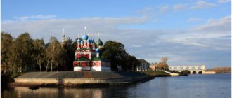
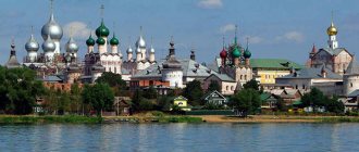
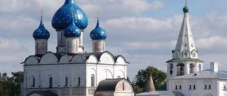
A large number of religious monuments have been preserved in the region. On the map of attractions of the Rostov region you can easily find real masterpieces of religious architecture. These are such pearls as the Ascension Military Cathedral in Novocherkassk, the Soldiers' Synagogue and the Armenian Church of Surb Khach, the temples of the Sovereign Icon of the Mother of God in the center of Donetsk and St. Nicholas the Wonderworker in the village of Nikolaevka, Neklinovsky district, Rostov region and many others. Recently, several mosques have been built.
Popular message topics
- Bone lace
Bone lace is usually called bone carving, which belongs to folk crafts. This type of creativity has been known for a long time, it is especially popular among residents of the north. Bone carving has a long history. The first products were simple, - Rivers of Voronezh
The river that flows in the city of Voronezh is one of the largest and most famous rivers in the Russian Federation; by the way, it is also one of the many tributaries of the Don and divides Voronezh into two equal parts, - Deer
One of the strong places in mythology and human jokes is occupied by the deer, or rather its antlers. There has long been a joke among the people that if a wife cheats on her husband, then he will have antlers and they will say that he is a deer.
Marriages and divorces
Detailed official statistics on registration and divorce of marriages suggest that the picture reflects nationwide trends. The number of newly created families for 2022 is 20,935, which is 20% less than in the previous period.
79% of registered marriages are dissolved. The number of divorces in 2020 decreased by 8%, but remains critical. Divorce statistics in cities are worse than in rural areas. The age of people getting married is growing, young people prefer informal relationships.