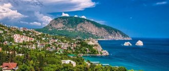
Mount Turkey is a natural landmark of the Tuapse region, located in the Black Sea forest reserve at a distance of 35–40 km from Tuapse. The mountain range includes the main peak Indyuk (859 m), as well as many rock outcrops. The protected place attracts attention with the beauty of the landscapes and the richness of flora and fauna. At the foot and on the slopes grow hornbeams, beeches, oaks, and sometimes there are coniferous trees. These places are inhabited by wild boars and raccoons.
The place is popular with tourists and rock climbers. Some elevations managed to receive “folk” names: these are the Turkey rocks (near the top of Turkey) and Turkey (a smaller rock, “hidden” behind Turkey).
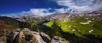
View from Turkey Mountain on Google Panorama
Mountains, rocks, gorges and caves of Greater Tuapse
Many rocks, deep cliffs and gorges are located in the Tuapse River basin, in the upper reaches of the Beshenaya, Tashtai and Chistaya rivers.
Each rock, each waterfall is beautiful and picturesque in its own way. Mount Semiglavaya, or rather the mountain range, closes the Tuapse section of the Main Caucasus Range from the east. Seven peaks with absolute heights from 1352 to 1453 meters are scattered over a little over four kilometers. In the middle part of the massif, basaltic porphyries of basic composition have an excellent pentahedral ground shape.
Mount Semiglavaya closes the Tuapse section of the Main Caucasus Range from the east and has scientific, educational and sporting significance. In the northwest, the beginning of the meadows coincides with the exit of the Yashkina trail from the forest, rising from the Tretya Rota tract. In the southeast, the border of Mount Semiglava is the tourist pass Semashkho II, 1323 meters above sea level. All seven peaks have rocky outcrops along their slopes.
Flora ranges from alpine herbs to fruit trees. In July-August, European blueberries ripen in these places.
Mount Shessi is 20 km away from residential villages. There are no lights, shops or bus services on this section of the route. The nearest settlement is the village of Altubinal. But the peak is visited, since Mount Shessi is the highest point of the Tuapse region and is 1839 meters above sea level.
The mountain is located at the junction of the Karatyansky ridge and a seven-kilometer jumper between it and the Main Caucasian ridge, which closes the basins of the Maly and Bolshoi Pshish rivers. The Chessy massif is composed of Middle Jurassic volcanic rocks. A two-kilometer arc of mountain meadows stretches along the ridges running from the dam and the Karatyansky ridge to the top. All around, especially in the north, granite towers are piled up, with steep screes underneath them. Lots of fancy pine trees on the rocks. Subalpine herbs at the very top and on the rocks of Semashkho (1744 m) in areas transform into alpine. The transition to subalpine is sharp, visible to the eye. The chain of peaks is surrounded by never-drying springs.
Mount Semashkho is located northeast of the city of Tuapse, six kilometers from the Krivenkovskaya railway station (as the crow flies). The height of the mountain is 1035 meters above sea level. The name of the mountain comes from the Adyghe word “sameshkho” - a large heap. Indeed, the mountain is a heap of boulders and rubble. The pre-summit slopes and adjacent areas of the Main Caucasus Range are free from forest and are occupied by upper belt meadows with elements of subalpine vegetation. There are a lot of strawberries, ripening a month later than below (in early July). In recent years, after a ground fire, the places once occupied by strawberries are being reclaimed by lily of the valley. At the foot of the main dome in the east and west there are never-drying springs. From here you can clearly see the peaks of the Main Caucasus Range, the sea, the city of Tuapse, and in good weather you can even see the chimneys of the thermal power plant of the city of Krasnodar. The area of open and semi-open spaces of the main dome and adjacent bare areas of the Main Caucasus Range is 25 hectares. The diversity of the underlying surface (small screes, thick turf, rocks, etc.) gives an extremely multi-species floristic picture.
History: During the defensive operation to protect the city of Tuapse during the Great Patriotic War of 1941–1945, both domes, the main and small (0.5 kilometers to the west), were the scene of stubborn fighting. On the top of Semashkho in 1982, a memorial complex “Fortitude of the Komsomol” was erected.
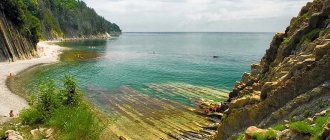
Kiselev Rock is located four kilometers northwest of Tuapse, between Cape Kadosh and the mouth of the Agoy River. The high Kiselev rock juts out into the Black Sea like a triangular stone cliff. The side facing the sea makes an indelible impression. This is a smooth, concrete wall 43 meters high, descending steeply into the depths of the sea. It consists of rhythmically interlayered thin layers of marls and sandstones, placed parallel to the seashore. On the flat cliff top, beneath the broadleaf forest, remains of marine sediments with pebbles and fossilized fauna are preserved. At the foot of the cliff there is a small beach, which arose because the waves gradually destroy the side slopes of the cliff. But the front side of the rock is strong and confidently withstands the elements. The rock got its name in honor of the artist Alexander Alexandrovich Kiselev, who depicted this amazing miracle of nature. It was here that the fishing scenes of the comedy “The Diamond Arm” were filmed.
The rock and pebble beach at the foot attract both townspeople and numerous tourists in the summer, some live in tents for weeks. The place here is of extraordinary beauty, and the sea water is clean and transparent.
Kiselev's Rock is one of the first natural monuments of the Tuapse region. The height of the rock is 46 meters. The Kiseleva Rock is part of the Kadosh protected forest park. The park area is 300 hectares. The area of the rock is 1 hectare.
History: The Circassians who lived here before their mass murder by the Russian Empire called this rock “the rock of tears.” A sad legend about the love of an Adyghe girl and a boy is associated with the rock. At the beginning of the 20th century, not far from the rock there was a painter’s dacha, where M. Gorky, I. Aivazovsky, A. Serafimovich and other famous cultural figures lived.
Route: you can get to the rock on foot along the seashore from the city of Tuapse (to the northwest) or from the village of Agoy (to the southeast). If by car, then drive from Tuapse towards Agoy, and after a couple of kilometers turn sharply left onto an asphalt road that makes a steep loop uphill. After driving about 1 km further, you will see several concrete slabs to the right of the road. From there, a well-worn forest road will lead you to the top of the Kiselyov rock. Leaving the car in a forest clearing among pine trees, go further to the sea on foot along the path. Go down to the stream and walk along it for 200 meters and you will get straight to the beach near the cliff. It is better to take drinking water with you. Please do not leave trash behind - it’s clean not where they clean up, but where they don’t litter!
Mountain “Two Brothers” is located 4 km northeast of the village of Anastasievka. Two peaks rise at a distance of 100 meters from each other: western (889 m) and eastern (921 m). The southern walls are vertical and reach a height of 120 and 90 meters.
The cave in Mount Nebeb is a tunnel 3-4 meters wide, 6 meters high, 22 meters long.
Mount Turkey is located 3 km southeast of the Goytkhsky pass. The mountain is a small spur (1.5 km) of the Main Caucasus Range. The height of the mountain is 859 meters. From the west, the wall rises 200 meters above the surrounding walls. The mountain is one of the five first natural monuments. The summit consists of hard volcanic rocks. There are accessible caves in the mountain. At the top there are pine trees, and on the approaches there are chestnuts, oaks and many flowers. All rock outcrops are used by climbers for training and competitions.
The caves of Mount Turkey are accessible to tourists. In one of the caves, traces of the presence of primitive man were discovered; notches are visible on the walls.
Rock Orlan is located 8 km northwest of the village of Altubinal. The rock is a single complex of vertical pillars, blocks, “feathers,” and spiers. The height of the rock walls is from 40 to 80 m. The geological and geomorphological monument is very promising for sports development. Eagle Rock Located 8 km northwest of the village of Altubinal. The rock is a single complex of vertical pillars, blocks, “feathers,” and spiers. The height of the rock walls is from 40 to 80 m. The geological and geomorphological monument is very promising for sports development.
The Tooth Rock is located on the steep southern slopes of the Main Caucasus Range, 6.5 km northeast of the Krivenkovskaya railway station. It is very spectacular from the railway side. The area of the rock is 2 hectares.
Bee rocks and “Honey caves” . The fabulously beautiful places are located in the vicinity of the villages of Terziyan and Altubinal on the Pshish River. The name of the rocks and caves is explained by the fact that they were inhabited by families of wild bees that produced honey. In hot weather, honey flowed in drops from the crevices of the rocks. The foot of the rocks is covered with mountain herbs and linden trees, which contributed to the emergence of a wild apiary. The route is designed for tourists with a guide.
Guam Gorge - this amazing place is located in the neighboring Absheron region on the Kurdzhips River; on the northernmost edge of the Lagonaki plateau. The gorge is the gateway to the mountainous region. It is 3 km long and 400 m deep. In some places the gorge narrows to 3 meters. A narrow-gauge railway runs through the gorge. Silvery streams of waterfalls run down the slopes. The rock outcrops on both sides of the river are awe-inspiring. They are white, pink green, yellow, red. The vegetation of the gorge is no less diverse. Many travel agencies organize excursions here in the summer.
The Wolf Gate gorge is one of the most interesting places in the resort. The trail runs under the White Rocks to the Wolf Gate along the bed of the Spider River. The length is about 2.5 km. There is a six-meter waterfall with a deep bath. You can swim in it. Ferns, all kinds of local vines, chestnut, oak, and hornbeam grow in the forest.
Tuapse outpost
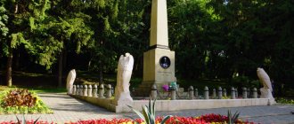
Events during the Great Patriotic War are associated with Mount Semashko. This is evidenced by the monument at the top, erected in 1982. The memorial complex is called “Fortitude of the Komsomol”. It consists of three huge PPSh machine guns, placed vertically. There are three anti-tank hedgehogs standing nearby. Monuments to the defenders of the heights and mass graves can be seen a little lower, from the side of Mount Turkey. They are also on the road to Mount Two Brothers.
Echo of a bygone war
During the war, the defense line of Tuapse passed here. The Germans broke through to the Semashko and Two Brothers mountains in October 1942. They were opposed by the 10th Rifle Brigade of the Red Army. Fierce fighting lasted for half a month. The German units were surrounded and driven away from Tuapse. The defensive operation was part of the battle for the Caucasus.
Prose writer Evgeny Astakhov wrote the novel “Breach of the Rules,” in which he mentions the battles on Semashko. It describes an amazing story when a chain of 5 thousand women and children stretched along the mountainside to transfer food and ammunition to the fighters. From hand to hand. Astakhov also has a poem with the lines: “I was killed near Tuapse on the slope of the Semashkho height.” Later a song was written based on these words.
Memory of the defense of Tuapse
Memorial plaques are even installed on trees and stones. There is still a lot of material evidence of those events left in the mountains - spent cartridges, fragments, helmets. To the side of the trail, you can actually stumble upon cartridges, unexploded mines and shells. For this reason, these places attract “black diggers”.
Geography and origin
Mount Chessy has an altitude of 1839 m above sea level. The ridge, of which it is an integral part, is composed of volcanic rocks originally from the Middle Jurassic period. It is rarely visited: organized groups come here no more than 3-4 times a year.
The origin of the name of the natural attraction is also attractive. Most likely, the toponym came from the Adyghe word “shesy” (“shysy”), which translates as “hostage”: why she was christened that way is not yet clear. Middle name – Sadig. This word also refers to the Adyghe language, meaning “to sit on the mountain.”
The object is 40 km away from Tuapse, and the nearest settlement is already 20 km away. Its name is Altubinal (translated from Turkish as “farm of six glades”). It is a small village consisting of one street. Only about 20 people live here, and such amenities as electricity, shops and transport links are simply absent. However, the village is often used as a starting point for various hikes in the mountains, Chessy is no exception.
According to reviews from tourists who were able to overcome the difficult route on Chessy, the trip is worth the time and effort. Both the flora and fauna of this area are diverse, and the landscapes are remarkable for their wildness and pristineness, which gives the mini-trip a special atmosphere.
Mountains of the Krasnodar region. Review of 28 peaks for tourism and hiking
The Krasnodar region is rich in natural beauty for relaxation, sports and simply enjoyment. There are so many attractions that it is difficult to even guess their exact number.
Resorts Yuga.ru decided to bring a little clarity and prepared a list of mountains in the region that are often - or not very often, depending on the complexity of the route - visited by tourists. Here is a clickable list, and below is text with a brief description of each of the places listed.
Karabetova mountain
This is not exactly a mountain, but rather the largest active mud volcano, which is located on the Taman Peninsula. Its height is 152 meters. It is also called Karabetova Sopka and Karabetka. The closest place to the volcano is the village of Taman. Visually, the hill does not look intimidating; it is a high hill with a flat top. The volcano's eruption occurs almost continuously, and catastrophic eruptions occur, according to sources, every 15-20 years.
Bald Mountain
The mountain is located near the village of Durso, from which there is a path to the top. The route is not difficult for hikers with basic skills and suitable equipment. The height of Bald Mountain is 284 meters above sea level. The mountain received this name due to the fact that its slopes are practically devoid of vegetation.
Lead Mountain
The mountain is located near the village of Shapsugskaya and reaches a height of 683 meters. From the top there is a view of the surroundings of the city of Abinsk, the villages of Akhtyrsky and Kholmsky. As local residents say, the mountain got its name because the Circassians who lived here used to have a forge on this mountain where they cast bullets. This version is confirmed by the fact that when the Cossacks came to these lands, they discovered large reserves of lead in the cave, which is also called Svintsovaya.
Shize is the highest point of the Gruzinka ridge and reaches 542 meters. The mountain is located near the village of Erivanskaya, and the hiking route to the top begins from there. The ascent is quite simple and does not take much time, so the route is suitable for tourists with a basic level of training.
Chubata Mountain
Chubata Mountain is of interest only to a rare tourist, perhaps because its size does not cause much admiration. But this is still not entirely fair. Chubata Mountain is an incredibly attractive object in its beauty, which is located on the Kotsekhur ridge of the Main Caucasus Range between the Lysaya (Shapsugskaya) and Krestovaya mountains, on the way from Shapsugskaya to the Thunder Gates. From the top there is an unforgettable view of the neighboring mountains.
Conquest of Chessy. About the route and more
The road from the tiny village of Altubinal to the foot of Mount Chessy is well-rolled, smooth, and does not cause any problems. However, the further path will not be easy: the places are wild and impassable. Finding the right path, the easiest and best visible, is not so easy: you need to stock up on patience, determination and endurance. The main landmark on the route is a wooden tourist booth (house), which is approximately 15 km away from the beginning of the route. From here to the top of the mountain it is only about 3 km, but the roads going up are quite steep, rocky, completely overgrown with thorny bushes.
At the end of the hike, tourists will see a stunning panorama. From the highest point of Chessy you can see the following mountains:
- Peaks of the Lagonaki plateau;
- Semiglavaya (Kashina) (about 1400 m);
- Semashkho (1035 m);
- Turkey (859 m);
- Grachev Venets (1544 m);
- Battery (750 m);
- Big Okontu (1430 m);
- Cathedral-rock (1205 m);
- Orlan.
Eagle-eyed travelers will also see the main mountains of Greater Sochi, the Republic of Adygea, the hilly environs of Apsheronsk and Belorechensk - there are many natural monuments of the Black Sea region to be seen. It is instructive that the hills that get used to Chessy are somewhat lower, which is why the height here is felt much stronger, and the view, unobstructed by anything, is much more extensive.
There are many never-drying springs flowing at the top of the mountain, and in the surrounding area there are many interesting sights: waterfalls, dolmens, Bee Rocks, Honey Caves. On the northern slopes of Chessy there are towers, below them there are screes. Fir and pine trees grow on the rocks - powerful, centuries-old and thin, intricately curved; closer to the top, wonderful subalpine meadows spread out. Thickets of rhododendron, dense groves, fragrant flower meadows - the high mountain landscapes enchant with their rich flora.
It is worth gathering a large group on a hike to the highest point of Tuapse: tourists often encounter bears along the way - there is a zoological reserve, where wild boars and other fauna also live. On some trails you can also come across hunting lodges and tents, often empty.
The route to Mount Chessy is not suitable for all travelers. It will be quite difficult for inexperienced, physically weak and intolerant people. Many vacationers, unprepared for the upcoming loads, turn around halfway. Please also note that the initially chosen path may lead to a dead end: then you will have to turn around and look for the right road again.
You should take with you a sufficient amount of food, water, and prepare comfortable shoes and equipment. Often, together with Chessy, they explore other nearby peaks, then the trip lasts for 2-4 days.
Note to the naturalist
Since the path to the mountain goes through forest thickets, along the way there is an opportunity to get acquainted with the peculiarities of the local flora. The main representatives of the world of trees are fir, oak, oriental beech, hornbeam, noble chestnut, and maple. There are Caucasian linden, alder and ash. There are even fruit trees - pear, apple, dogwood, cherry plum. You'll be lucky if you come across a cherry, pistachio or walnut. True, wild animals are significantly inferior to their cultivated counterparts in terms of taste.
The subtropical climate suits climbing plants. They often entangle trees from top to bottom and resemble huge snakes. It looks scary in the dark. Among these it is worth noting ivy, wild grapes and birch. Typical shrubs are elderberry, hawthorn, and rosehip. The autumn curlew is very beautiful. This is the name of an unusual orchid whose flowers spiral up the stem.
The subtropical climate suits climbing plants
Unlike other peaks, the slopes of Mount Semashko are almost treeless. This is the kingdom of subalpine meadows. In summer, there are quite a lot of strawberries on the slopes, but they ripen much later than those growing below. Berries can be picked from the beginning of July. Lilies of the valley are found in spring. The space between the lifeless patches of scree is occupied by thickets of low-growing juniper.
There are bears in the forests, but encountering them is unlikely. But the chances of seeing a hare are high. Among fur-bearing animals you can meet squirrel, weasel or marten. There are jackals, foxes, wild boars and wolves. Turtles and raccoons are common in these areas. There are deer and roe deer that are not afraid to show themselves to humans. The forests are full of birds. Their voices and singing sound continuously. Orioles, jays, goldfinches, thrushes, eagle owls - this is a far from complete list of birds.
To the delight of tourists, there are few mosquitoes and flies. But there are plenty of bees and butterflies. In June, fireflies put on a real fireworks display. The mesmerizing spectacle is worth seeing with your own eyes. Cicadas will entertain you day and night. Reptiles are represented by snakes, snakes, red and gray vipers. Lots of lizards. The diversity of the animal world is due to the fact that Mount Semashko is located on the territory of the Prichernomorsky reserve. And although its security is not up to par, the animals feel more at ease here.
How to get there (get there)?
It is not possible to get to Altubinal by bus from Tuapse - there is no public transport. Only personal transport is at your disposal.
From the farm, part of the route can be covered by car, but we recommend leaving the car here and going to conquer Chessy on foot. Here is your route on the map:
route Altubinal - Mount Chessy
Note to tourists
- Address: Apsheronsky, Tuapse district, Krasnodar region, Russia.
- GPS coordinates: 44.108060, 39.575290.
Mount Shessi in the Tuapse region is a hard-to-reach place, but that makes it even more attractive. Here you can see magnificent alpine meadows, dense fir and pine thickets, formidable rocky outcrops, but the most interesting thing is the spectacular panorama of inaccessible mountain ranges stretching all the way to Sochi and the North Caucasus. In conclusion - a video tour, enjoy watching!
The result of a systematic approach
In 1979, traffic was opened on the Goryachiy Klyuch – Tuapse railway line. Climbers and climbers knew the mountain well up to this point, but transport accessibility significantly added to its popularity. Mount Turkey has turned into a training ground for Kuban alpine clubs. It was during this period that new routes of varying difficulty categories appeared. Alas, no one documented them then and many were forgotten.
In the second half of the 90s, the concept of “sport climbing” appeared, which led to a systematic approach to the development of the mountain. Groups of rock climbers from Novorossiysk, Sochi, Krasnodar, and Maykop began to regularly come to the Tuapse region. Then equipped routes arose, which were carefully documented. In total, there were about three dozen routes not only on Turkey, but also in the vicinity of the mountain.
There are more than 70 climbing routes in the area
Now there are more than seventy climbing routes of varying difficulty in the area. Their total length is 150 meters. The rocks are thoroughly cleaned of moss. Unreliable stones have been removed. All routes are signed and equipped according to modern requirements. Currently, Turkey is considered one of the best climbing sites in the region.
The entire area is divided into three climbing sectors - “Feathers”, “Guard” and “Crown”. Already from the name it is clear that “Crown” is the top of Mount Turkey. Climbing routes are mainly laid around the mountain. The easiest route is “Runners”, the most difficult is “Ruslo”. And then there is “Moonlight Sonata”, “DaZdraPerMa”, “March 8” and others. All of them are very diverse.
It should be noted that the Indyuk mountain range is a recognized venue for various large-scale events. In the early 90s, the rock climbing championship of the USSR Ministry of Defense was held here. Ten years later, the first guidebook, written by Gennady Dultsev, was published. It gave a detailed overview of the area and described routes.
Then the Krasnodar Territory rock climbing championship took place. In 2006, a new project called “Rocks of the South” was launched. This was the first climbing festival held in these parts. For six years, the festival brought together climbers from different parts of the country.
Marathons were organized on Turkey with the largest number of the most difficult routes. The organizers approached the matter with humor, calling these competitions “Space Pigs”. In 2012, Turkey became a venue for all-mountain climbing events. These competitions were organized by the Kuban Mountaineering Federation.
There are many approaches to Turkey Mountain. All paths go to two main overnight sites, which are called “Spring Glade” and “Lokomotivsky overnights”. Usually they start from railway platforms 1744 km and 1860 km. You can also go up from the Indyuk station, but this route is a little longer.
Tuapse. Description of the resort, popular hotels and beaches.
Weather
Tuapse – Caucasus Mountains and Black Sea
Tuapse translated from Adyghe means “confluence of two rivers”. The city, surrounded on three sides by mountains, is located in a picturesque bay, at the mouth of the river of the same name, carrying the waters of rapid streams: Pshenakho and Chilipsi. The coastline is relatively narrow; in many places the mountains come almost close to the sea.
The resort villages of the region are located along the entire coast - from the borders of Greater Sochi to Dzhubga. The humid subtropics in the Shepsi and Tuapse region delight with lush vegetation: slender palm trees, blooming magnolias and other exotics. As you approach Dzhubga, the air becomes drier, the climate closer to the Mediterranean. The coast of the Tuapse region is protected by the Caucasus Range from cold air, and the summer heat is easily tolerated thanks to the sea breeze.
Adventures from our tourist club in this direction
12.02 – 14.02 |
3 days Southern flower journey: Caucasian cyclamens and snowdrops
Rocks and dolmens of the foothills of the Caucasus
Along the Lesser Caucasus Mountains: Five Peaks
What besides the beach? Sights and entertainment in Tuapse
Cafes and restaurants, entertainment centers, discos and nightclubs provide evening leisure for vacationers.
Sightseeing lovers and those wishing to see interesting places are also not left out. From the city they organize excursions to a group of dolmens near the town of Stone Quarry; to the valley of the Shahe River to numerous waterfalls; to Cape Kadosh to the Kiselev rock - a unique natural monument. The triangular cliff protruding into the sea was seen by all fans of the film “The Diamond Arm”. It was on the beach near Kiselev Rock that the fishing scene was filmed.
But the city cannot be called a purely resort: there is a fairly large port and an oil refinery. Therefore, many people prefer to relax in neighboring resort villages.
What to see?
A hike to Mount Semashko can be combined with exploring the surrounding attractions. First of all, these include Mount Turkey with a height of 859 meters. It is a popular place for training and climbing competitions. Numerous remains surrounding the mountain give it a fantastic appearance. Weathering processes have created rocks riddled with caverns. Because of this, they looked like cheese with holes.
The neighboring mountain Two Brothers is often called “Camel” for its resemblance to humps. It has two clearly defined peaks, located a hundred meters from each other. The eastern one has a height of 921 meters, the western one – 889 meters. Mushrooms, blueberries and lingonberries grow on the slopes of the mountain. There are several routes of varying difficulty along the mountain. A stunning mountain panorama opens from above.
The remains are a popular place for training and rock climbing competitions.
Shpichatsky Stream is a stream about six kilometers long. It is a tributary of the Pshenakho River. It cannot be said that the stream is powerful and full of water. But it has a cascade of 13 waterfalls. They have a height of 3.5 to 17 meters. Some formed wells up to eight meters deep. The bizarre rocks of the gorge along which the water stream rushes are impressive.
There are several waterfalls in the vicinity of the mountain
There are also waterfalls on the Dvubratsky stream, which is also a tributary of Pshenakho. They are located 2.5 kilometers from the village of Anastasievka. Some of them are quite affordable. The first four waterfalls range in height from three to seven meters. But from the fifth to the ninth are giant waterfalls. Water falls from a height of 10-18 meters. There are a dozen more waterfalls upstream, but to get to them you will need climbing equipment.
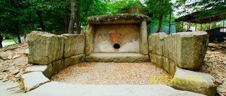
Not far from the village of Anastasievka, in the valley of the Pshenakho River, there is the megalithic complex “Psynako-1”. Archaeologists discovered a huge mound with a diameter of 70 meters in 1973. The height of the dome was about five meters. The uniqueness of the mound is that in its central part there is a dolmen made of stone slabs. The arched hole was closed with a massive stone “plug”. There are no analogues to the Psynako-1 mound.
The megalithic complex is composed of huge boulders
Scientists have found that the dolmen was surrounded by circular walls up to 180 centimeters thick and more than three meters high. Most likely, there was originally a wooden dome over the dolmen. A dromos, a narrow twelve-meter corridor, led to the front wall. In some places its cross-section did not exceed half a meter. The purpose of the structure still remains a mystery. Unfortunately, it is badly damaged.
200 meters from the first complex upstream there is a second one, which is called “Psynako-2”. Previously, there were five dolmens here, but to date only one has survived intact. The other four are debris and ruins. The surviving dolmen is made from a single block of rock. And this is not the only fact that emphasizes the uniqueness of this megalithic complex.
From Dzhubga to Shepsi
Dzhubga is a “access to the sea” for residents of the regional center. On weekends, a stream of cars from Krasnodar and other cities of Southern Russia rushes towards the sea, and the nearest beaches are in Dzhubga. Therefore, it is always crowded here; numerous campsites and recreation centers are never empty. Private hotels and guest houses have replaced the usual “rooms without amenities” - holidaymakers have a choice. The village has a wonderful water park "Dzhubga", and a dolphinarium was recently opened in the Nadezhda microdistrict. There is no shortage of bars, restaurants, and kebab shops. In addition, Dzhubga is not so far from Gelendzhik and Novorossiysk and you can go there on a one-day excursion.
If you go towards Tuapse, then the next resort village will be Lermontovo (more often called Lermontovka). It is located in a stunningly beautiful mountain valley. And the “Golden Coast” beach here is wonderful - sand and pebbles, one of the best on the coast. The small cozy village seems to be created for relaxation. It is especially convenient to come here with children: the seabed is flat, plus sand on the beaches. Lermontovka also has its own water park - “Chernomor”.
In the valley of the Nechepsukho River is Novomikhailovsky or Novomikhailovka, as the locals call it. The village is famous due to the nearby Orlyonok camp, as well as the only yacht club on the coast with a convenient harbor. Boat trips on yachts and catamarans, exciting excursions in the surrounding area, a wonderful embankment with a whole range of seaside entertainment, and most importantly, the magnificent sea - Novomikhailovka is deservedly considered the pearl of the Tuapse region.
Cozy and well-groomed Olginka has transformed in recent years. A new embankment, a clean, well-maintained beach, private hotels, a modern resort complex “Gamma” - it’s a pleasure to relax here. The complex includes hotels “Gamma 5*” and “Gamma 4*”; SPA-center; entertainment with a nightclub, bowling, billiards; indoor and outdoor swimming pools; sports grounds; children's playroom; own beach. The Orbita health complex is also located in Olginka; the Leto water park was opened in 2009.
The small village of Nebug is located at the mouth of the river of the same name, surrounded by forested mountains. Amazingly picturesque place. Plants characteristic of the subtropics are already found here. Nebug is considered the entertainment center of the entire region: the first water park in Russia “Dolphin”, the Ice Palace, the “Aquamir” dolphinarium, and an oceanarium will appear soon.
Just twelve kilometers from Tuapse, just beyond the pass, in a picturesque river valley, lies the village of Agoy . The nature here is stunning: mountains covered with coniferous and deciduous forests, raging rivers and noisy waterfalls, clear sea and wide pebble beaches.
Immediately behind Tuapse are the resort villages of Dederkoy and Shepsi . In the valley of the Dederkoy River there is a monkey nursery. Surrounded by mountains, immersed in greenery, Shepsi nestles comfortably - a calm place, ideal for a family holiday. From here it is convenient to go on an excursion to Sochi.
Fact 3. Cascades of waterfalls
Tuapse is located in a mountainous area. Just 7 kilometers from the city you can see a waterfall – and not just one, but a whole complex. This miracle of nature is located near the mouth of the Dederkoy River.
The complex is divided into two groups of waterfalls: upper and lower. The height of the water fall ranges from 3 to 20 meters. It is noteworthy that the lower and upper waterfalls are very different in appearance, since they have different sources of origin and natural relief.
After admiring the waterfalls, don't forget to look around to see the valley of pink orchids, mountain slopes covered with wild ivy, and picturesque hills.
Where to stay in Tuapse
- Parking
- WiFi
- Parking
- Playground
- Parking
- WiFi
- Parking
- WiFi
- Playground
We offer holidays in Tuapse without intermediaries and overpayments, we have current 2022 prices for accommodation in the private sector, hotels and hotels. There are plenty of accommodation options, from budget hostels to five-star suites.
We recommend paying attention to off-center objects. The center is quite expensive, and the beaches opposite are always crowded with tourists. It is better to settle further from the center, but closer to the beaches, where there are fewer conventions and lower prices. You should pay attention to the areas of Kadosh, Primorye, Vesna (Zvezdny). There are many mini-hotels, guest houses and just private housing.
Tuapse is a foothill city, there are many steep ascents and descents, you will overcome them several times a day. However, the climate is mild Mediterranean and any hike from the sea to your place of residence will be a wonderful walk.
Fact 9. The most Armenian city on the coast
Statistics show that more Armenians live in Tuapse than in any other city on the Black Sea coast. There is no official division of Tuapse into districts based on ethnicity.
But when you come here, you will find that as you approach the city center, the concentration of Armenians per square meter is rapidly increasing.
Tuapse is a city of hundreds and one attractions. A city of sea, mountains, trees and clear air. The city of aromatic shish kebab and honey churchkhela. Cheerful nights and quiet peaceful dawns.
Yes, this is an industrial city, which slightly reduces the romance, but adds firmness to its character. At the same time, Tuapse remains a sultry brunette who will gladly receive you, feed you to your heart’s content and organize an educational and entertainment program. And if you like to travel, our reviews will help you feel confident in distant countries.
How to get there
Tuapse is a large transport hub with good connections. Mostly vacationers come here by train. The city has its own railway station, through which all trains heading to Adler pass. Sometimes guests fly to the airport of Krasnodar, Adler or Gelendzhik, and then they need to travel about 150 kilometers - all three airports are approximately the same distance to the resort. You can get there by bus or taxi. The road will run through the picturesque Caucasus Range - these views will be a worthy addition to the overall vacation experience. You can also travel from Sochi and other large coastal cities by boat. It's even more exciting.
Total information
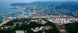
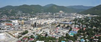
Tuapse is the center of the administrative region of the Krasnodar Territory. Greater Tuapse includes a number of settlements from Dzhubga to Shepsi. Although the city itself is not a legally recognized resort area, more than a million people vacation there every year. The local population is about 63,000 people. The city, first of all, is a large Black Sea port, specializing in the transportation of petroleum products. This does not have a negative impact on the environment. Moreover, the beaches and the port are relatively separated. So, you can safely come on vacation to Tuapse.
The history of the city is quite long. Five centuries ago, tribes settled here, leaving behind dolmens - unique architectural buildings characteristic of the Caucasian coast. Then there was one of the major centers of the slave trade. It was during the 6th century BC. the name “Tuapse” appeared, which can be translated as “two rivers”. The city became Russian in 1829, but was then abandoned again, and finally returned only in 1864.
Fact 5. The first settlers settled in Tuapse thousands of years ago
Historians love to get to the bottom of the truth, and in the case of Tuapse it turned out that the history of the city has its roots in ancient times. Archaeological excavations indicate that the tribes that inhabited these places already lived here in 3000 BC.
It was their mighty hands that built dolmens - structures whose reliability would be the envy of any modern building. Even after so many centuries, they have retained their original appearance. You can admire these monuments on the territory of the Tuapse Local History Museum and in the ancient village of Dzhubga.
- Buy a ticket to the Tuapse children's camp
Things to do
When you come on vacation to Tuapse, you can take the opportunity to see the local attractions, of which there are plenty. For example, the Kiseleva rock is a unique natural monument with almost vertical walls. It is located 4 km from Cape Kadosh and is considered the calling card of Tuapse. Having been here, you definitely need to take a photo against the backdrop of this miracle of nature. Not far from the cape there are two forested areas - “Kadosh” and “Varvinka”. There you can find the unique Pitsunda and no less beautiful Crimean pines, 255 species of orchids, vines and many other representatives of the Caucasian flora. On local rivers there are quite picturesque mountain waterfalls, one of which at the mouth of Kazennaya is 33 m high. And, of course, ancient dolmens, without which it is difficult to imagine the history of the Caucasus.
Mysteries of toponymy
Scientists have long puzzled over the origin of the strange name of the mountain, but have not come to a consensus. Some argue that the basis was the Adyghe word “hinikushkh”, which is translated into Russian as “mountain of Hindus”. According to another version, the mountain was named because of the Sinds, a small people who in ancient times inhabited the territory of Transkuban. But where is the word “Sind” in the name of the mountain? In the Adyghe language, “mountain of Sinds” will also be “hinikushkh”!
Both versions have obvious shortcomings. It is not clear why so much attention was paid to the Hindus, who live very far from these places. And so little is known about the Sindhis that their existence can generally be classified as mythology. And the word “hinikushkh” itself, even in pronunciation, is very far from “turkey”.
Conquered peak
They also say that the mountain used to really resemble a turkey’s head, but as a result of geological disasters it lost its original shape. This assumption also does not stand up to criticism. The lost resemblance of a mountain to a bird seems incredible, since “turkey” is a Russian word. This means that the name of the mountain should have appeared quite recently, no more than two hundred years ago. However, during this historical period there were no major natural disasters that could so radically change the appearance of the mountain.
Climate
The climate in Tuapse is subtropical with high levels of humidity. The Caucasus ridge delays air flows coming from the continent, thereby ensuring windless weather. The warmest months are July and August, but there is practically no scorching heat here. Rain is also quite rare. The air temperature does not rise above 28 degrees, which is quite comfortable. The water warms up to 24 degrees, in other words, Tuapse has ideal conditions for relaxation. The swimming season begins in May and lasts until mid-October. Only in winter the city is less comfortable; there are frosts, although not often.
Average monthly air temperature by month
| Jan. | Feb. | Mar. | Apr. | May | Jun. | Jul. | Aug. | Sep. | Oct. | But I. | Dec. |
| +6° | +6° | +8° | +12° | +18° | +22° | +25° | +25° | +21° | +17° | +12° | +9° |
Average monthly water temperature by month
| Jan. | Feb. | Mar. | Apr. | May | Jun. | Jul. | Aug. | Sep. | Oct. | But I. | Dec. |
| +6° | +6° | +8° | +10° | +15° | +20° | +23° | +24° | +21° | +17° | +12° | +9° |
And without water, neither here nor there
In the vicinity of the Turkey mountain range, the proximity of the warm sea has a great influence on the weather pattern. Winter is characterized by large amounts of precipitation. Snow in the mountains can lie from December until the end of March. The average thickness of the snow cover is small - about 30 centimeters. However, in lowlands, two-meter snowdrifts can also occur. In winter, strong gusty winds blow in the mountains.
It should be borne in mind that there are very few sources of water directly near the rocks. You need to stock up on water at the foot of the mountains
Summer is hot and dry. August is considered the “hottest” month. The least precipitation falls in June. Most streams dry up in summer. But during heavy rains, floods are possible. Water in rivers can rise sharply and remain at high levels for up to a week. The most favorable time for conquering Turkey (as it sounds!) is the periods from mid-April to early July and from September to the end of October.
It should be borne in mind that there are very few sources of water directly near the rocks. This is especially true during the hot summer period. A fairly large stream flows along the slopes of Turkey Mountain, but it also dries up. There are no problems with water until June. The most difficult situation arises in August, when the springs dry up near the “Rodnikovaya Polyana” and “Lokomotivskie Nochki” camps.
The never-drying spring is located between Turkey Mountain and the turkey outcrop. A marked path leads to it from Rodnikovaya Polyana. The marks are made with white and blue paint. The spring is about 20 minutes walk. Not far from it there is a small parking lot, from which you can identify the location of the source.
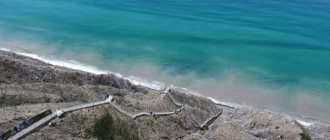
Beaches
The coast in the area of the city center and the embankment is occupied by the port. Therefore, all the beaches are located south and partially north of this zone. The central beach is located on the left bank of the Tuapse River. Its length is about 1.3 km, and its width is 50 m. The beach is covered with a mixture of sand and small pebbles. The relief of the day is uniform without changes. The beach is equipped with all the necessary services. Just below is the Volna beach. It is less crowded. Covered with pebbles. On the northern side, there are several semi-wild beaches on Cape Kadosh. There are already large pebbles and rocky terrain.