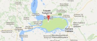
Syzran is located on the territory of the Samara region. The satellite map of Syzran is located on the coast of the Volga River.
A map is the best assistant on any journey. It helps to understand the interweaving of roads in an unfamiliar area and find the shortest routes to a populated area. The most amazing and beautiful sights can be found with its help. The map allows you to independently create convenient routes for walking around the city. After all, using it, it’s easy to find any house number and the most inconspicuous alley.
Syzran has a unique deposit of oil shale. Map of Syzran scheme
Indicates that sandstone and sand deposits are located near the city. You can also use it to find deposits of water sources.
Map of Syzran with streets
The main street of the city is Sovetskaya. A map of Syzran with streets in the historical part of the city will help you find it. It is a monument to the urban architecture of the city. The original name of the street was Bolshaya.
On the territory of this street there are many architectural monuments of the 20th century. The buildings are examples of Art Nouveau and eclecticism.
In past centuries, numerous shopping arcades and shops lined the street.
Currently, Sovetskaya Street is the administrative and business center of the city. The building of the zemstvo government and the Sterlyadkin mansion will help you find a map of Syzran with streets in good quality.
Important roads of regional importance pass through the city territory.
The city and railway lines cross the city. They carry trains in six directions.
Transportation within the city is carried out using buses and minibuses.
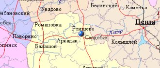
A map of Syzran by district will help you find the following areas of the city:
- In the central part of the city territory there are many monuments of ancient architecture. Beach areas are nearby.
- Near the central area you can find the Shanghai district, as well as the Military Town and Decembrist Street areas. Along Dekabristov Street there is a descent to the Volga River.
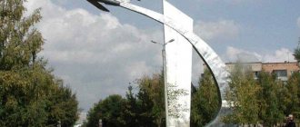
- The helicopter monument is considered the pride of the Military Town area.
- In the Shanghai region you can find the Tyazhmash factory complex.
- A map of Syzran with streets and houses will allow you to find the Mongory district, which is a residential area of the city.
- The private sector predominates in the Rudnik and Zapadny districts.
- In the very center of the city you can find the Brick district.
- A military unit has been formed on the territory of the village of Serdovino. A military unit is predominantly located on its territory.
- On the opposite bank of the Syzranka is the Zasyzran district. It is famous for its tomato fields.
- Yandex maps of Syzran will help you find the Kashpir district. Industrial facilities are located next to it. On its territory there are mainly two-story buildings.
Skip to content
Main menu:
- HomeAbout the organizationGalleryProjectsAchievements PartnersSport. Teams.Our sportUsefulCreativityContacts
- home
- About the organization
- Gallery
- Projects
- Achievements
- Partners
- Sports Teams
- Our sport
06/16/2017 Origin (etymology) of the word Syzran.
The history of the founding of the city of Syzran is inextricably linked with the founding of other cities and villages (towns, etc.) in the area. It is clear that development always proceeded along trade routes and from borders; in the Volga region, first fortresses, later cities, were based on the Volga River, then fortresses were based on tributaries. Let's go through the years of founding of cities in the district, starting from the west, Penza (1663), Kuznetsk (1699), Saransk (1641), Alatyr (1552), Surskoye (1552), Karsun (1647), Ulyanovsk (1648), Sengilei (1666 ), Terenga (1682), Shigony (1480), Tolyatti (1737), Samara (1586), Khvalynsk (1556), Baltai (1696), Petrovsk (1698). On the map, inside this area (circled in black), there are forests and swamps, in some places even relict ones; of course, the boundaries are conditional. The main inhabitants of some settlements were “runaway” peasants who appeared here long before the founding of fortified cities.
Now let’s remember where the peasants fled from the landowner, to the forests and swamps. There weren't many forests left in central Russia and the Black Earth Region. People fled beyond the Volga, beyond the Urals. Some of the freedom-loving people remained in the local forests. Some people were intoxicated by the newly acquired freedom and were drawn to a crazy path, and this is how the Zhiguli Freemen was formed; nature itself created favorable conditions for this.
Let's return to Syzran, as we know, the year of foundation is considered to be 1683. Not far from the source of the Syzranka River, which gave the city its name, there is one of the sources of the Syzganka River, a distance of about 20 km. Isn’t it true that the names of these rivers are consonant. Let us pay attention to the year of formation, consonant with the word Syzran, Syzgan (later Bazarny Syzgan), Syzganskaya Sloboda was founded in 1638 by archers. It is clear that there cannot be two settlements with the same name. Why exactly did it turn out to be Syzran, and as a Western European clerk (German, French, etc.) writes down the word Syzgan from the words of a commoner speaking the southern dialect of the Russian language (for example, a Cossack), let's read the name of our city written in Latin, Syzran - we will hear Syzgan. Both settlements received their names from the rivers of the same name, the basins of these rivers (the Syzganka basin is circled in yellow, the Syzranka basin is circled in green. It becomes clear that both rivers received their names from the toponym Syzgan. Translated from Tatar, the word “Syzgan” means ran away, escaped, etc. words for those times “runaway.” In modern words, “freedom-loving.” Every Syzran citizen can call himself freedom-loving.
There is a version that the word Syzran was formed from the phrase “from the wound”. Barge haulers got up from the wound to pull the barges. I think barge haulers appeared in these places later than the formation of Syzran, because the banks were full of robbers, and barges were a very tasty morsel, and the barge haulers themselves could rebel and go into the forests with goods. It was more profitable for ships to move with sails and oars.
Umyarov I.
Home | About the organization | Gallery | Projects | Achievements | Partners | Sports | Useful | Creativity | Contacts | Map of site
Map of Syzran with houses
Syzran has long been a merchant city. Traveling through the streets of the city, you can find many remarkable objects. There are more than three hundred of them in the city.
Using the Syzran routes on the map, it is worth visiting the following attractions:
- On Sovetskaya Street you can see beautiful ancient buildings: the mansion of the merchants Syromyatnikov, the house of the Klars, the building that belonged to the tradesman Myasnikov and other buildings.
- A drama theater and a park area for children can also be found on Sovetskaya Street.
- Ancient houses, which are examples of the architecture of the past two centuries, can be found on Kirov and Ulyanovskaya streets.
- In the city you can see the Kremlin. Of its buildings, the Church of the Nativity of Christ, as well as the Spasskaya Tower made of stone, have been preserved. Inside the tower you can visit an interesting museum. A detailed map of Syzran will help you find these objects. The architectural complex is surrounded by a beautiful square with numerous monuments.
- The magnificent Kazan Cathedral is also worth a visit. It was built in the 19th century. The temple contains unique shrines - these are icons with particles of the relics of saints.
- The oldest building in the city is the Ilyinsky Monastery. Which appeared in the 17th century.
The city has its own icon painting school. You can learn the history of the city in the local history museum. Where unique collections of paintings, sculptures and decorative arts are presented. The halls of the museum contain more than 50 thousand exhibits.
History of Syzran
Hotels in Syzran | Photo of Syzran | Map of Syzran Weather Syzran | Sights of Syzran Restaurants in Syzran | Souvenirs of Syzran | Video of Syzran
The history of Syzran begins in 1683 - the year of the founding of the future rich merchant city and the amazing outback of modern Russia. Syzran became one of the first cities founded in the East of the Russian State, thanks to the order of Peter Alekseevich and on the initiative of Grigory Kozlovsky. The history of Syzran is closely connected with the military history of Russia, because the fortress city was erected to protect the trade route flowing along Mother Volga. In the 18th century, Syzran assumed the role of a trade center and became the largest and most significant in the eastern territory near the Volga region, since then the merchant class has been born and firmly established here.
The history of Syzran, associated with trade, brought good income to the region for those times, thanks to which its rich architecture began to appear. Syzran traded in black bread and cattle, and soon both of these goods appeared on the coat of arms of the successful city. Syzran became part of the Simbirsk governorship in 1781, then - the Simbirsk province. At the end of the 19th century, a railway was built through Syzran, which provided a more reliable connection between the city and the surrounding regions. The history of Syzran at the turn of the 19th-20th centuries is closely connected with the flour-milling industry, taking an honorable fourth place in the ranking of cities engaged in this industry. In 1906, a terrible fire occurred in Syzran, which completely destroyed the wooden buildings of the city and claimed the lives of thousands of people. Rich merchants at that time began to create magnificent stone mansions, which today can be seen in the charming historical center of Syzran. The further history of Syzran is developing actively - over a dozen large industrial enterprises and about a hundred small ones appear in the city. During Soviet times, deposits of oil and oil shale were discovered in the region, which brought it great fame and significantly enriched the treasury. Syzran was jokingly nicknamed “The Second Baku” for its large amount of valuable natural resources - fuel materials. In 1928, the city received the status of the center of the Syzran district of the Middle Volga region. The Great Patriotic War brought many victims to the history of Syzran - more than 11 thousand people died at the front and most of the city suffered. Despite large-scale losses and incredibly difficult times, several large enterprises were evacuated to Syzran at that time, thereby increasing its industrial potential fivefold. The subsequent history of Syzran has only positive pages in its book.
Cities
City of Syzran
- a city in the Samara region of the Russian Federation. Administrative center of the Syzran region. Located on the right bank of the Saratov reservoir of the Volga River. The population as of the end of 2011 is actually 179.4 thousand people. There are ~275 thousand people in the agglomeration. The city is located at the foot of the Volga Upland, on the right bank of the Volga River (Saratov Reservoir), at the mouth of the Syzranka River, 137 km west of Samara downstream. The nearest city is Oktyabrsk, 19 km away. The city of Syzran, like the entire Samara region, is located in a time zone designated by international standard as the Moscow Time Zone (MSK). The offset relative to Coordinated Universal Time (UTC) is +4:00 (MSK). The city got its name from the Syzran River (currently Syzranka), on which the fortress was founded. In the description of the 18th century, the hydronym is indicated in the forms “Syza”, “Syzan” from the Tatar “syza” “ravine, beam”; the element “ran” can be explained as an indicator of the Chuvash initial case, corresponding to the Russian preposition “from”[6]. Based on this, the Turkic name means “ravine river flowing from a ravine, low-lying river.”
Education in the city of
Syzran
The education system in Syzran has rich traditions that were laid back in the days of the zemstvo. And the building of the First Women's Gymnasium, built in 1914, still serves young people.
branch of the Samara State Technical University Syzran Polytechnic College branch of the Samara State Economic University Syzran Mechanical and Technological College representative of the Samara State University Syzran Medical College Branch of the VUNTS Air Force VVA named after. Professors N. E. Zhukovsky and Yu. A. Gagarin Syzran College of Arts and Culture named after O.N. Nostsova
Military Institute
From June 1, 2010, the Syzran Higher Military Aviation School of Pilots will be reorganized into a branch of the Air Force Academy named after Professor N. E. Zhukovsky and Yu. A. Gagarin. It is the only domestic educational institution in the country in the field of training pilots for military aviation helicopters[23]. The school trains pilots (Syzran) and technicians (Kirov) on helicopters for the Armed Forces and other departments of the Russian Federation. Currently, the school has 10 departments, laboratories, specialized rooms and simulators. The history of the Syzran Higher Military Aviation School of Pilots dates back to the Saratov Military Aviation School of Pilots, formed in March 1940. Since 1953, he switched to the development of a fundamentally new aviation technology - the helicopter. Since 1960, the school has been located in Syzran. Since 1963, it has been called the Syzran Military Aviation School of Pilots. In 1966, the school was transferred to higher status. Foreign military specialists from Tajikistan, Armenia, Kazakhstan, Kyrgyzstan, China, the Republic of Chad, Vietnam, Angola, Laos, Djibouti, Mali, Sri Lanka, Libya, Mongolia, Sudan and Nicaragua are trained within the school’s walls. Many graduates of the Syzran Military Aviation Institute became outstanding people - they became masters of sports of the USSR and Russia, Heroes of the Soviet Union and earned the title of Hero of Russia; the names of several graduates are included in the Guinness Book of Records.
Economy
of the city of Syzran
It ranks third in the Samara region in terms of industrial potential (the volume of goods shipped, work performed and services of its own production in 2007 amounted to 20 billion 770 million rubles). Main sectors of the economy: heavy industry, light and food industries, construction, transport, small business, trade. The city has a well-developed industrial sector; there are about 30 large and medium-sized enterprises engaged in industry. The basis of the industrial potential is made up of large enterprises of the oil refining, chemical and petrochemical and machine-building complexes. “Syzran Oil Refinery” is part of the Samara group of oil refineries, acquired by “Oil City Syzran”, the historical coat of arms of the city of Syzran was taken, approved on December 22, 1780, the true description of which reads: “In the upper part of the shield is the Simbirsk coat of arms. At the bottom there is a black bull with a golden floor, signifying the abundance of this kind of cattle.” Gold in heraldry is a symbol of strength, greatness, wealth, intelligence, and generosity. Black color in heraldry symbolizes prudence, wisdom, modesty, honesty and the eternity of existence. Green color symbolizes abundance, life and rebirth.
Author group: Author of the reconstruction of the coat of arms: Konstantin Mochenov (Khimki); computer design: Sergey Isaev (Moscow)
Approved by resolution of the Syzran City Duma (#15) dated March 27, 2002.
FlagcitiesSizran- not yet approved and therefore absent
Photos of Syzran
Syzran: Photos Weather Map Hotels
Countries of the worldRussiaCitiesSyzran
1
This collection contains 47 photographs of Syzran, its views, houses and attractions, which were taken by local residents, tourists and photographers. All photos of Russian cities and attractions are presented in high quality, we hope that this will help you get to know them better.
VKontakte facebook twitter
Photos of other Russian cities Photos of Moscow Photos of St. Petersburg Photos of Sochi Photos of Tula Photos of Yaroslavl Photos of Vladimir Photos of Voronezh Photos of Yekaterinburg Photos of Ryazan Photos of Tver Photos of Sevastopol Photos of Dmitrov Photos of Rostov the Great Photos of Ivanovo Photos of Orel Photos of Nakhodka Photos of Belgorod Photos of Bryansk Photos of Volgograd Photos of Kazan Photos of Kaluga Photos Krasnodar Photo Lipetsk Photo Nizhny Novgorod Photo Penza Photo Samara Photo Saratov Photo Smolensk Photo Tambov Photo Chelyabinsk Photo Anapa Photo Kolomna Photo Yuzhno-Sakhalinsk Photo Vladivostok Photo Grozny Photo Izhevsk Photo Kostroma Photo Kursk Photo Omsk Photo Perm Photo Rostov-on-Don Photo Ufa Photo Cheboksary Photo Chita Photo Kerch Photo Pushkin Photo Sergiev Posad Photo Murom Photo Yeisk Photo Abakan Photo Saransk Photo Dolgoprudny Photo Balashikha Photo Irkutsk Photo Kirov Photo Novosibirsk Photo Orenburg Photo Podolsk Photo Ulyanovsk Photo Essentuki Photo Magadan Photo Alushta Photo Mytishchi Photo Krasnoyarsk Photo Togliatti Photo Khabarovsk Photo Myshkin Photo Kaliningrad Photo Rybinsk Photo Stavropol Photo Suzdal Photo Tomsk Photo Tyumen Photo Pyatigorsk Photo Ukhta Photo Astrakhan Photo Blagoveshchensk Photo Murmansk Photo Novorossiysk Photo Pskov Photo Ulan-Ude Photo Gelendzhik Photo Uglich Photo Pitkyaranta Photo Arkhangelsk Photo Barnaul Photo Vologda Photo Yoshkar-Ola Photo Kemerovo Photo Kurgan Photo Magnitogorsk Photo Nalchik Photo Surgut Photo Taganrog Photo Yakutsk Photo Simferopol Photo Balakovo Photo Svetlogorsk Photo Ordzhonikidze Photo Zheleznovodsk Photo Engels Photo Komsomolsk-on-Amur Photo Armavir Photo Vladikavkaz Photo Makhachkala Photo Norilsk Photo Tuapse Photo Yalta Photo Torzhok Photo Ples Photo Alexandrov Photo Volgodonsk Photo Angarsk Photo Bratsk Photo Naberezhnye Chelny Photo Novokuznetsk Photo Syzran Photo Cherepovets Photo Sudak Photo Veliky Novgorod Photo Kislovodsk Photo Kalyazin Photo Mineralnye Vody Photo Kovrov Photo Belokurikha Photo Pereslavl-Zalessky Photo Sortavala Photo Derbent Photo Petrozavodsk Photo Syktyvkar Photo Feodosia Photo Novocherkassk Photo Vyborg Photo Kozelsk Photo Elista Photo Balaklava Photo Foros Photo Nizhnevartovsk Photo Petropavlovsk-Kamchatsky Photo Pechory Photo Salekhard Photo Tobolsk Photo Valdai Photo Yuryev-Polsky Photo Nizhny Tagil Photo Severodvinsk Photo Anadyr Photo Zadonsk Photo Khanty-Mansiysk Photo Priozersk Photo Vorkuta Photo Temryuk Photo Dzerzhinsk Photo Kirzhach Photo Gatchina Photo Kronstadt Photo Elabuga photo of the great Ustyug photo Maykop photo of the old Russa photo miass photo Hasavyurt photo of Shlisselburg photo Alupka photo bachisaray photo of Peterhof photo of the great Luke photo of the Baltiysk photo of Nevyansk photo of Nevyansk photo of Nevyansk photo Kidekshi photo Verkhoturye photo of the Ostashkovsk photo of Chernyakhovsk photo of the Ussuriyska photo Photo of Sterlitamak Photo of Zelenogradsk Photo of Neman Photo of Sovetsk Photo of Polessk Photo of Severomorsk Photo of Roslavl
Sizran
Description Photos Weather Map Hotels
See also: Photos of Cabarete, Sights of Madagascar, Cities of Peru, Cameroon, Nikko, Oklahoma City, Bashkiria National Park, Venus Pavilion