News and Society September 30, 2017
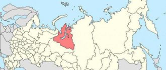
The city of Vysotsk, Leningrad region, is a port city of Russia, located on the shores of the Gulf of Finland, on the island of Vysotsky. The city was renamed several times, it was Trogzund (until 1917), Uuras (from 1917 to 1948), and from 1948 - Vysotsk. This smallest town in terms of population is 30 kilometers away from the city of Vyborg and is a railway station. The city was previously closed, but is now open to the public. The area of the settlement is about 39 square kilometers. What is the history of the city? How does he live now? What attractions of the city attract tourists?
Historical sketch
During the Northern War in the 18th century, the entire territory of Finland became part of the Russian Empire. At the same time, the Vyborg province of St. Petersburg province was organized. Peter I came up with the idea of placing a fortification here; he founded a fortress, the purpose of which was to cover the approaches to the city of Vyborg from the sea. Thus, in the narrowest place of the Vyborg Bay, a fortification was built, which was named Trongsund (from the Swedish “trong” - “narrow”, “zund” - “strait”).
At the beginning of the 19th century, the Principality of Finland was formed, which was part of the Russian Empire.
After the October Revolution, the Finnish lands gained independence and became the state of Finland. The city was renamed Uuras (Finnish for “hardworking”). During this period of the settlement's history, a railway was built and work began on dredging the seabed to create a seaport from Uuras. In 1926, the Tyurisevya-Limatta railway was built. In the early 30s, dredging work was completed.
In 1939, the Russian-Finnish war began, after which, in 1940, a peace treaty was concluded, according to which part of the Vyborg province became part of the USSR. The acquired territory was divided, its northern part went to the Karelian Autonomous Soviet Socialist Republic, the city of Uuras became part of the Vyborg region.
During the Great Patriotic War, from the summer of 1941, the city was occupied by Finnish troops and liberated by the Soviet army in the summer of 1944.
In 1944, the area became part of the Leningrad region.
Sea port
The convenient natural bay of the Gulf of Finland has been used since ancient times as a pier where timber was loaded onto large ships. In the summer, up to two thousand ships (steamers, sailboats) could be loaded here. In winter (until the advent of the railway and electrification of the village), the port was empty. Thus, navigation of the port was carried out only for 8-9 months.
Currently, the port is connected to the mainland by road and rail. It has been actively developed since the 1990s, when terminal complexes were built here.
The naval base of the FSB border ships is located in the city of Vysotsk.
In the 2010s, the Vysotsk seaport consisted of two terminals - oil products and coal; currently construction of another one is underway - a timber terminal.
Navigation these days in the seaport of Vysotsk is year-round. In winter, navigation is accompanied by icebreakers.
City cultural and educational institutions
Despite the fact that the town is very small, there is an elementary music school for children, painting and theater arts are taught in the Children's Creativity Center, a Children's Art School, the Stanislav Rostotsky Museum, and the “Station of Young Naturalists” operate.
There is a city library.
In the city there is only one kindergarten “Borovichok”, the only preschool institution where there is no waiting list.
Youth of the city
The youth of the city participates in various spheres of life in Vysotsk - politics, economics, social sphere. The Young Guard of United Russia and the Youth Council have been created and operate in the city, which initiates many competitions, festivals, competitions, and holidays for youth and children.
Young people actively participate in city cleanups and in cleaning memorial complexes and mass graves.
The younger generation actively participates in regional sports competitions and other events.
Tourism
Every resident of a large city from time to time wants to breathe fresh air, take a break from the bustle of the city in nature, admire sunsets and sunrises, but at the same time not be deprived of city amenities. The city of Vysotsk seems to have been created for this type of vacation.
And the popularity of green tourism is growing every year. Residents from all over the country and neighboring countries flock here. Clean air, picturesque nature, hospitable residents - all these factors attract vacationers here. There are two tourist complexes “Saari Tour” and “Pikhtovoye” on the shore of the bay. There is a Russian bathhouse, bowling alley, billiards, and sauna.
Holidays in the city of Vysotsk, Leningrad region, have become very popular and contribute to the economic development of the city.
Road trip to Vysotsk. Old fort and picturesque skerries
Content:
Located in the northwestern tip of Vysotsky Island, the settlement of the same name with the status of an urban settlement is, of course, famous not only for the number of people living here. The places here are marked with historical artifacts. Which testify to the glorious and heroic pages of the development of our Fatherland. Well, besides, it’s also very beautiful here. It was for this beauty and history that I set off in my car on my next journey.
Road to Trongsund Fortress. Primorskoye Highway
The choice of road on this journey was deliberate for me. By car you can get to Vysotsk from the Northern Capital in several ways. Two of them, with varying degrees of variation, are:
- along the Scandinavia (A-181, also part of E-18) and near Vyborg (or at the junction near Kirpichny-Kirillovsky) turn south;
- along Primorskoye Highway ( 47A-082 ) with an exit near Sovetsk at 41K-098.
I took a more southern road. Along Primorskoye Highway. I particularly like it and am very familiar with it.
Unlike the faster “Scandinavia”, Primorskoye Highway is more picturesque, runs (in places) along the very shore of the Gulf of Finland and, driving along it, you cross the famous St. Petersburg Riviera. It is no coincidence that there are so many camps and recreation centers along this highway. Along the Primorskoye Highway, the path goes through the most famous St. Petersburg resort areas. The shores of the bay with sandy beaches, picturesque coniferous forests, clean natural air - all this opens up to the eyes of anyone who finds themselves on this road. And if there is no need to rush, the trip is conducive to leisurely and meditativeness, then I recommend (and I myself prefer) to go towards Vyborg (also to Vysotsk) along this highway.
Sandy beaches of the Gulf of Finland near Repino. Saint Petersburg
There are also several stops along the way for sightseeing. For example - Stirsudden Lighthouse, or stop by Primorsk.
(I will make separate reviews about both of these roads (“Scandinavia” and “Primorskoye Highway”) over time).
The distance from St. Petersburg to Vysotsk is about 120 km. I entered the point “Trongsund Fortress” into the navigator. After a couple of hours of leisurely driving (there are many speed restrictions along the Primorskoe Highway, especially near the Northern Capital. There are many settlements here), I reached the final destination of my route. The navigator took me to the walls of the Trongsund fort, to a picturesque coast, with a white mushroom-shaped dome of a lighthouse.
Lighthouse in Vysotsk
To be precise, this is not a lighthouse at all. A directional navigational luminous sign. The name of this particular one, installed on the very shore: “the forward alignment sign of the linear navigation alignment of Patteri.” This is how it is fully and correctly called in sailing directions.
Lighthouse in Vysotsk. Leningrad region. The Gulf of Finland. Road trip to Vysotsk
The second sign, located a little further from the shore, at a higher elevation, respectively: “rear alignment sign of the linear navigation alignment of Patteri.”
The operating principle of this navigation equipment will become clear from the diagram (given below) from the navigation manual:
Guiding navigation luminous signs. Principle of operation
The diagram shows that such navigation signs are installed in pairs. And on the exact correspondence of the direction line, which should indicate the axis of the fairway to the ship. That is, if the pilot sees that the lights of these two signs are aligned vertically exactly one above the other, then his vessel is following a safe fairway. And the coincidence of these lights is a guideline for tacking and maintaining the desired and safe course on the target line. Such signs are installed, as a rule, in places where navigation is difficult due to the complexity of the underwater terrain or the abundance of islands, skerries or shoals. And the Vyborg Bay, on the shores of which Vysotsk is located, is not the open sea. And the fairway here is not so simple.
The head of the rear alignment sign of the Patteri linear navigation alignment is identical (like the entire design) to its brother:
Rear glowing linear direction sign in Vysotsk
Well, since I got to the navigation signs, it’s time to tell you a little about the geographical location of Vysotsk.
Vysotsk Geographical position
The city of Vysotsk is located in the far west of the Leningrad region. On Vysotsky Island in the Vyborg Bay. This bay is part of a larger one, the Gulf of Finland. To get to Vysotsky it is not necessary to use water transport. A highway and a branch of the Oktyabrskaya Railway are laid here. The island is connected by a bridge with another smaller island - Maysky. And that, in turn, is connected to the mainland by a dam.
Vysotsky Island is just over 8.5 km long and about 3 km wide. In its northern part is the city of Vysotsk.
From Vysotsky Island to the city of Vyborg no more than 12-13 km directly along the waters of the bay. The land road is much longer. About 30 km.
Here, for example, from the shore where the navigator took me, Vyborg and the St. Olaf Tower of Vyborg Castle are very clearly visible:
View of Vyborg from Vysotsky Island
Vysotsky is the largest of the Vysotsky Islands archipelago (Trongsund archipelago). Next door to Vysotsky is Maly Vysotsky Island. The two islands are separated by a narrow deep-water strait - Trongsund (Trandzung Strait, Tranzung). This is an important waterway through which in the local skerries, among the many islands, the passage of ships with deep draft to the port of Vyborg is possible. And it was precisely to protect the Trongsund Strait that fortifications were once erected here.
Note: I was wondering how to correctly indicate the name of the strait. Different sources and maps have completely different toponymic transcriptions. What is clear is that a derivative of the Swedish Trångsund is used. Therefore, I will indicate mainly by the name of the settlement Trongsund (now Vysotsk)
Trongsund (Transund, Tranzund Strait):
Trongsund Strait (Transund, Tranzund)
Navigation sign in the strait:
Trongsund Strait
Trongsund Fortress Vysotsk
This is a defensive fortification, which has partially survived to this day. The fortress is located on the outskirts of the city. It was built to cover the city of Vyborg from the sea. It was built in 1867 at the narrowest point of the bay, an isthmus approximately 170 meters wide. The fortress consisted of bastions, batteries and casemates, which were created on the rocky shores of the island. But with the rapid development of artillery, the fortress turned into an ineffective structure. Currently, most of its fortifications have been destroyed, and the surviving part is heavily overgrown with forest.
It is an architectural monument of the Vyborg district of the Leningrad region.
The island is a geological natural monument. It occupies an area of about 41 hectares. Located 7 kilometers from the city of Vyborg and 2 kilometers from the city of Vysotsk. There are unique landforms here, which in geomorphology are called “ram’s foreheads”. They are rocks in the form of granites protruding to the surface. These rock formations are gentle and smooth on one side and steep on the other. Formed as a result of glacier movement.
Gustoy Island is a specially protected natural area of the Leningrad region. Here there are seaside meadows and herring vegetation, where animals listed in the Red Book of the Russian Federation live.
Primorskoye Highway
If you just need to quickly get from St. Petersburg to Vysotsk, then it is better, of course, to jump over the Fox’s Nose along the WHSD and go onto the Scandinavia highway. But! You and I are going on an exciting journey, right? Therefore, we choose Primorskoye Highway, right at the exit from the city.
This is one of the most picturesque routes in the northern direction. Just taking a breeze here is a pleasure. By car, motorcycle, bicycle. Which one is more pleasant? The Primorskoye Highway stretches from St. Petersburg all the way to Vyborg, which is why it is sometimes called the Nizhny Vyborg Highway.
The track is well equipped and has good surface. It meanders along the coast between pine forests, yellow beaches, huge boulders, old dachas, new villas and restaurants. The sun winks between the trees and it seems that even the seagulls are shouting after them “have a nice day!”
You will see through the window the famous Sestroretsky Razliv, the beaches of Komarovo, the Repin Penates, wave to Raymonda Dien, and drive across the resort Zelenogorsk, buried in flowers. And approximately, in the Molodezhny area, you will finally be able to turn on the gas. Yes, the area is popular, there are a lot of cars, traffic to Zelenogorsk on weekends... I would like to say difficult, but it would be more correct to say calm. We're on a walk.
| You may be interested: Between sky and water or one day near Priozersk |
But from Molodezhny, the resort part of the road ends and begins almost deserted. Everyone who dreamed only of a beach and a picnic had already stopped in Solnechny, Komarovo or crossed the Zelenogorsk park to Golden Beach. Further on there will be no less beaches, wild, clean, secluded, with sand combed by winds and waves and the usual muddy smell of the Gulf of Finland. In general, for those who are not lazy to get further away.
However, travelers are asked to pay attention to two pieces of advice:
- It’s better to go to the final point, and for us it’s the cape with the Trongsund fortress, and on the way back make stops to relax on the beach and explore other sights
- Don’t forget that the road is long, and the last gas station is just outside Sestroretsk. There is another one, in the area of the village of Sovetsky, almost before Vysotsky. No more gas stations were seen on Primorskoye Highway. And the distance from St. Petersburg to Vysotsk along the chosen road is about 230 kilometers
Routes from Vysotsk to Russian regions
Vysotsk - Adygea Vysotsk - Altai Vysotsk - Altai region Vysotsk - Amur region Vysotsk - Arkhangelsk region Vysotsk - Astrakhan region Vysotsk - Bashkortostan Vysotsk - Belgorod region Vysotsk - Bryansk region Vysotsk - Buryatia Vysotsk - Vladimir region Vysotsk - Volgograd region Vysotsk - Vologda region Vyso tsk – Voronezh region Vysotsk - Dagestan Vysotsk - Jewish Autonomous Okrug Vysotsk - Transbaikal region Vysotsk - Ivanovo region Vysotsk - Ingushetia Vysotsk - Irkutsk region Vysotsk - Kabardino-Balkaria Vysotsk - Kaliningrad region Vysotsk - Kalmykia Vysotsk - Kaluga region Vysotsk - Kamchatka region Vysotsk - Karacha Evo-Cherkessia Vysotsk – Karelia Vysotsk – Kemerovo region Vysotsk – Kirov region Vysotsk – Komi Vysotsk – Kostroma region Vysotsk – Krasnodar region Vysotsk – Krasnoyarsk region Vysotsk – Crimea Vysotsk – Sevastopol Vysotsk – Kurgan region Vysotsk – Kursk region Vysotsk – Leningrad region Vysotsk – Lipetsk region Vysotsk – Magadan region Vysotsk - Mari El Vysotsk - Mordovia Vysotsk - Moscow Vysotsk - Moscow region Vysotsk - Murmansk region Vysotsk - Nenets Aut. Env. Vysotsk – Nizhny Novgorod region Vysotsk – Novgorod region Vysotsk – Novosibirsk region Vysotsk – Omsk region Vysotsk – Orenburg region Vysotsk – Orel region Vysotsk – Penza region Vysotsk – Perm region Vysotsk – Primorsky region Vysotsk – Pskov region Vysotsk – Rostov region Vysotsk – Ryazan region Vysotsk – Samara region Vysotsk – St. Petersburg Vysotsk – Saratov region Vysotsk – Sakhalin region Vysotsk – Sverdlovsk region Vysotsk – North Ossetia – Alania Vysotsk – Smolensk region Vysotsk – Stavropol region Vysotsk – Tambov region Vysotsk – Tatarstan Vysotsk – Tver region Vysotsk – Tomsk region Vysotsk – Tula region Vysotsk - Tyva Vysotsk - Tyumen region Vysotsk - Udmurtia Vysotsk - Ulyanovsk region Vysotsk - Khabarovsk region Vysotsk - Khakassia Vysotsk - Khanty-Mansiysk aut. env. Vysotsk - Chelyabinsk region Vysotsk - Chechnya Vysotsk - Chuvashia Vysotsk - Chukotka Aut. env. Vysotsk - Yakutia Vysotsk - Yamalo-Nenets Aut. env. Vysotsk – Yaroslavl region
Routes from Vysotsk to regions of Ukraine
Vysotsk – Donetsk region Vysotsk – Kirovograd region Vysotsk – Lugansk region Vysotsk – Odessa region Vysotsk – Zhytomyr region Vysotsk – Dnipropetrovsk region Vysotsk – Sumy region Vysotsk – Kharkov region Vysotsk – Vinnitsa region Vysotsk – Chernihiv region Vysotsk – Nikolaev region Vysotsk – Kiev region Vysotsk – Lviv region Vysotsk – Zaporozhye region Vysotsk – Transcarpathian region Vysotsk – Ternopil region Vysotsk – Rivne region Vysotsk – Volyn region Vysotsk – Kherson region Vysotsk – Ivano-Frankivsk region Vysotsk – Cherkasy region Vysotsk – Chernivtsi region Vysotsk – Khmelnytsky region Vysotsk – Poltava region Vysotsk – Kyiv
Routes from Vysotsk to regions of Kazakhstan
Vysotsk – Karaganda region Vysotsk – Akmola region Vysotsk – Aktobe region Vysotsk – Kyzylorda region Vysotsk – East Kazakhstan region Vysotsk – North Kazakhstan region Vysotsk – Almaty region Vysotsk – Mangistau region Vysotsk – Zhambyl region Vysotsk – South Kazakhstan region Vysotsk – Kostanay skaya region Vysotsk – Atyrau region Vysotsk – Baikonur Vysotsk – Pavlodar region Vysotsk – Almaty Vysotsk – Astana Vysotsk – West Kazakhstan region
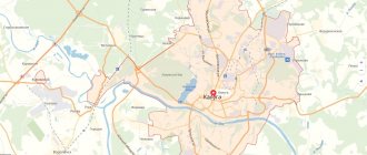
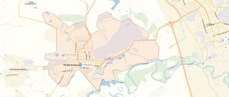
The city of Vysotsk on the online map of Russia. International name of the city of Vysotsk: Vysotsk . On the map you will find the main attractions of the city of Vysotsk, which you can see in 1 day; places of recreation in the city and beyond: hotels, restaurants, cafes, recreation centers, sanatoriums and agricultural estates.
The population of the city of Vysotsk is 1,152 people according to the census for 2015-01-01.
Postal code of the city of Vysotsk, Leningrad region: 188909.
City today
The main economically important enterprises of the city of Vysotsk, Leningrad Region, are currently: the Port Vysotsky coal terminal and the Vysotsk-Lukoil oil terminal.
The city administration will pay great attention to the improvement of the territory. The city takes an honorable 3rd place in the ranking of the most comfortable settlements in the Vyborg region.
The city of Vysotsk, Leningrad region, is the smallest town in terms of population. 1120 people live here.