Back in the 17th and 18th centuries, active development of Siberia and the Urals began, which is why the first settlements arose in the area of the current Artemovsky district during this period. These include the village of Pokrovskoye, the appearance of which dates back to 1621, the village of Lipino, which appeared in 1648, the village of Mironovo, which existed before 1663 and the village of Shogrish, the foundation of which dates back to 1668. Where the village itself is now located city, the earliest settlement was the village of Yegorshinskoye, founded in 1665, which was located on the right bank of one of the tributaries of the Irbit River - the Bobrovka River. This village was named after the Cossack Yegorsh Kozhevin, who in 1665 received a plot of land here. At first the name sounded like Yegorshin Povytok, then it was transformed into Yegorshina village, and already in 1864 there was already the village of Yegorshino.
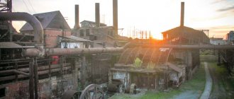
An important event was the founding of the Irbit Ironworks in 1776 by Savva Yakovlev (which was later renamed the Irbit Metal Rolling Plant). Thanks to this enterprise, a factory village appeared, which in our time is called Krasnogvardeisky. This plant received orders from the military department back in the Patriotic War of 1811-1813, from here cannonballs, grapeshot and bombs were sent to the front. Pudding furnaces and a steam hammer were built here only in 1866-1870, at the same time rolling mills were launched, which made it possible to produce sheet iron.
With a simple deepening of the well, which the peasant V.A. Skutin decided to do in 1871 on his estate in the village of Egorshinskoye, the discovery of the “Egorshinskoye coal deposit” began. The “black rocky soil” discovered at the bottom of the well turned out to be coal. Since 1872, industrial development of this deposit began, which consisted not only of industrial development, but also of study. The research was carried out at that time by simply geologist A.P. Karpinsky, who later became an academician.
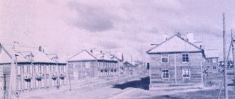
The pace of production increased, and the village itself grew. Already by 1904 there were 1,363 residents here, who were housed in 246 peasant households. Over 40 small mines were also built, which mostly belonged to the Nizhny Tagil Demidov plants, as well as to such plants as Sysertsky, Alapaesky and Verkh-Isetsky. The largest mines were “Klyuchi-1” (1907) with a depth of 82 m, “Sofia” (1913) with a depth of 105 m and “Bursunka” No. 2 (1914) 49 m in depth.
Naturally, the mined coal had to be transported. Therefore, it is not surprising that in 1913-1916. Railway lines were actively built, the length of which exceeded 500 km. At the same time, Yegorshino station became a hub, located at the intersection of major transport routes.
Revolutionary events and years of civil war
Revolutionary events were not left aside either. The Yegorshinsky Council of Workers' and Soldiers' Deputies appeared here in March 1917, and in November it took power. Already in February 1918, all coal mines were nationalized.
The Civil War brought fierce battles with the White Guards near the Yegorshinsky mines. In May 1918, a volunteer detachment appeared to help the Red Army, which consisted of Egorshin miners. In August of the same year, they began to form the Kamyshlovsky regiment, which was recruited at the Irbitsky plant (now this village is called Krasnogvardeysky).
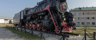
After the retreat of the Red Army from Yekaterinburg at the end of July 1918, the troops marched just through Yegorshino towards N. Tagil, scattered units were reorganized, and Yegorshino itself held the defense. Only in the fall of 1918 did the soldiers of the 1st Peasant Com. The regiment (which later became the Red Eagles regiment) managed to stop and then push back the Kolchakites in the Yegorshino area. Now this place is the Krasnye Orly station. In memory of the soldiers who fell near Yegorshino, an obelisk was erected in the park near the Yegorshino station in 1920.
The events of those days were described in P. P. Bazhov’s essays “Formation on the Move,” since the author himself participated in everything that happened as the editor of “Trench Pravda.” The effectiveness of the organization of defense was most influenced by G. A. Usievich (commissar of the front) and M. V. Vasiliev (commander of the 1st brigade of the Eastern Division). The 1st Peasant Committee also played an important role. regiment, led by F.E. Akulov.
Another book about those times, “Red Eagles,” was written by F.I. Golikov, who was a regiment machine gunner at that time. He later achieved the rank of Marshal of the Soviet Union. But in the end, Yegorshino was still left to the white troops; only in July 1919 did the cavalry group of N.D. Tomin liberate the area from Kolchak’s troops.
Development of the region in the pre-war five-year plans
Naturally, the devastation created difficult conditions for the normal work of the miners, but they managed to be among the first in the Urals to fulfill the established socialist plan for coal mining. So in 1920, 3.2 million pounds of coal were mined. It was possible to restore the Sofia mine. Since 1921, coal from the Egorshinsky deposit was delivered to St. Petersburg factories and factories. M.I. Kalinin himself spoke at a rally in front of the miners on June 29, 1921.
The Bobrovskaya mine in 1921 was renamed the mine named after. Artyom, although “Artyom” is only the battle nickname of the famous Bolshevik revolutionary F.A. Sergeev, who became the chairman of the Central Committee of the Russian Union of Miners and died during the testing of an aerocar.
Electrification of the country has also affected the area. Regional power plants near the Egorshinsky anthracite mines were included in the GOELRO plan among the first among 30 new power plants. The Egorshinskaya station has a capacity of up to 40 thousand kW. The first stage of the power plant was launched in October 1922. The village of Egorshino in 1924 became the center of the established Egorshinsky district, and a year later, the scattered mining villages were united into a single working village named after. Artem. In the new village, according to the population census conducted in 1926, there were 2911 inhabitants.
In the pre-war period, new mines were built and manufacturing enterprises were opened. The largest mine was the mine named after. Kirov. A bakery, an industrial plant, a carriage depot and other enterprises were created. The second stage of Egorshinskaya State District Power Plant named after. The October Revolution made it possible to produce power up to 24 thousand kW. The infrastructure also developed: secondary schools, office buildings, hospitals and a cinema. By 1926, the number of settlements in the district had increased to 67, and the district center was moved to a village located near the Yegorshino station.
A new power plant called “Red October” was opened in October 1923, its capacity was 1200 kW. Its launch made it possible to electrify not only the mining village, but also the surrounding villages. The first stage of electrification affected Yegorshino and was completed by January 1926. The following year, the village of Pokrovskoye, which was the largest in the area, was electrified.
October 1930 brought the appearance of the Yegorshinsky Regional Radio Center, which was one of the largest in the Urals. By November 1931, the first radio mobiles and switchboards were manufactured.
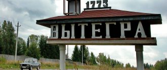
Since April 20, 1935 p. Parshino, s. Egorshino, the village and railway station of Egorshina, the Klyuchi mine, the New settlement and the New mine mine were included in the workers' settlement of Artemovsky village (Egorshino district). This delineated the territory where the city of Artemovsky and the village itself later arose. Egorshino ceased to exist. On December 4, 1938, a Decree of the Presidium of the Supreme Soviet of the RSFSR was issued, which transformed the workers' village named after. Artem to the city of Artemovsky with district subordination.
Already almost before the war, in 1938, exploration of a new coal deposit was carried out - Bulanashsky. The Bulanash 1–2 mine was launched only in March 1943.
Artemovsky
Egorshinskoye coal deposit
The first settlements on the lands of the modern Artyomovsky urban district appeared in the 17th–18th centuries. - during the period of active development of Siberia and the Urals, among them: the village of Pokrovskoye (1621), the village of Lipino (1648), the village of Mironovo (previously 1663), the village of Shogrish (1668).
In 1665, the white Cossack of the Aramashevskaya settlement, Yegorsha Kozhevin, was granted a plot of land on the right bank of the Bobrovka River (a tributary of the Irbit). Based on the name of the Cossack, this place was given the name Egorshin Povytok, later - Egorshina Village, and since 1864 - the village of Egorshino.
By decree of the Berg College in 1776, Savva Yakovlev founded the Irbit ironworks (later Irbit metal rolling) plant, thanks to which a factory village arose (now the village of Krasnogvardeisky). In 1811–1813 Here orders from the military department for the production of bombs, cannonballs and grapeshot were carried out. In 1866–1870 Pudding furnaces replaced furnace production, a steam hammer was launched, as well as rolling mills for the production of sheet iron.
In 1871, in the estate of the Egorshin peasant Vasily Andreevich Skutin, while deepening a well, residents discovered “black rocky soil.” This is how the Yegorshinskoye coal deposit was discovered. The very next year, 1872, was the year of the beginning of coal mining, its industrial development and the study of coal deposits. The deposit was studied by geologist, future academician Alexander Petrovich Karpinsky, who noted that the Yegorshinskoye deposit is the best on the eastern slope of the Urals, and the coal is similar in appearance to either ordinary coal or anthracite.
Since 1873, the construction of small mines began, of which in the period from 1873 to 1894. More than 40 were built here. They were mainly in the possession of the Nizhny Tagil Demidov plants, as well as the Sysert plant, Verkh-Isetsky and Alapaevsky plants. Some mines belonged to merchant industrialists. The largest mines were: the Klyuchi-1 mine with a depth of 82 meters (1907), the Sofia mine with a depth of 105 meters (1913), and the Bursunka mine No. 2 with a depth of 49 meters (1914).
In 1902, 352,700 pounds of coal were produced at the Egorshinsky coal deposit, in 1905 - 409,700 pounds. The population of the village grew. So, in 1904 there were 246 peasant households with 1,363 inhabitants.
During this period, enterprises in the Urals were actively developing, requiring efficient fuel - the “coal rush” began. But transporting coal in the absence of a railway was very expensive. In 1913–1916 More than 500 kilometers of railway track were laid, the Yegorshino station arose, which became a hub, being at the intersection of important transport arteries. In 1914, the first stage of the Yegorshino-Apparatnaya railway was put into operation, and in January 1917, train traffic began along the entire length of the North-Eastern Ural Railway.
After the October Revolution
In March 1917, the Yegorshinsky Council of Workers' and Soldiers' Deputies was created, which on November 12, 1917 took power in the village into its own hands. Just 3 months later, in mid-February 1918, the Yegorshinsky coal mines were nationalized.
With the beginning of the Civil War on May 28, 1918, a Red Army detachment was created from among the Yegorshin miners; on August 10, 1918, the formation of the Kamyshlovsky regiment began at the Irbit plant (Krasnogvardeisky village). On July 25, 1918, the Red Army troops left Yekaterinburg and retreated to Nizhny Tagil through Yegorshino, scattered units were reorganized, and from July 19 to September 23, 1918, the defense of Yegorshino took place.
According to Pavel Petrovich Bazhov, who was the editor of Trench Pravda and a participant in those events, much of the credit for organizing the defense belonged to the commander of the First Brigade of the Eastern Division, Makar Vasilievich Vasiliev, and the front commissar Grigory Aleksandrovich Usievich. In the battles of Yegorshino, the First Peasant Communist Regiment “Red Eagles”, commanded by Philip Egorovich Akulov, distinguished itself. Regimental machine gunner Philip Ivanovich Golikov wrote a book (memoir) “Red Eagles” about his comrades in arms. Later F.I. Golikov became Marshal of the Soviet Union. In memory of the fallen heroes, one of the railway stations west of the modern city of Artyomovsky was named “Red Eagles”.
Yegorshino, by order of the command, was left to Kolchak’s troops, but in July 1919 the White Guards were driven out of the village by a cavalry detachment under the command of N.D. Tomin.
The Bobrovskaya mine was flooded, but by the end of 1920 the water was pumped out and the restoration of underground workings began. In 1921, the Bobrovskaya mine was renamed the Artyom mine in honor of Fyodor Sergeev, known as “Comrade Artyom” - a revolutionary and Bolshevik, Lenin’s comrade-in-arms, chairman of the Central Committee of the All-Russian Union of Miners, who died while testing an aerocar. An intensively developing mining settlement was also named after Artyom.
On October 28, 1923, at 12 noon, the Red October power plant was launched (power 1,200 kW). Conceived, designed and even partially built (construction was interrupted with the outbreak of the First World War) by the Prince of San Donato Elim Pavlovich Demidov, who was a co-owner of the Nizhne Tagil mountain district, the power plant was included in the GOELRO plan in 1920, it was rightly called the “First-born GOELRO in the Urals". The launch of the power plant made it possible to begin electrifying the mining village, and then the surrounding villages. Electricity came to the mines, where the restoration of the mining industry and the reorganization of mining operations were underway.
On February 10, 1924, the Yegorshinsky district was formed with the administrative center in Yegorshin. The district was formed as part of the Sverdlovsk district of the Ural region from the former volosts of Egorshinskaya, Pokrovskaya, Shogrinskaya, Bolshe-Trifonskaya and Lipinskaya of the Irbitsky district of the Perm province. In 1925, the Mironovskaya volost of the Nizhne Tagil district was annexed to the district. As a result of these transformations, new Soviets were formed - Artemovsky, Mostovsky, Sarafanovsky, Mironovsky and Gostkovsky.
In 1925, all mining villages were united, and the Artemovsk Village Council was formed, which included delegates from the Egorshinskaya, Artemovskaya, Klyuchevskaya and Bursunskaya mines. The village of Egorshino and the enlarged Artemovsky village were included on equal rights as part of the Egorshino district. According to 1926 data, there were 67 settlements in the region. In the Artemovsky village there were 2,911 inhabitants, in the village of Egorshino - 2,537 inhabitants, at the Egorshino station - 1,339 inhabitants.
On January 9, 1926, the first stage of electrification of the village of Yegorshino was completed; after some time, current through high-voltage lines entered the houses of Alapaevsk, Sukhoi Log and Asbest. In 1927, electricity came to the village of Pokrovskoye, the largest village in the Yegorshinsky district.
On October 1, 1930, the Yegorshinsky District Radio Center opened, becoming one of the largest in the entire Urals. A radio workshop was organized under him, designed to speed up radio installation work. On November 8, 1931, the first products were produced - radio mobiles and switchboards. The formation of the first radio plant in the Urals, Egorshinsky, was taking place.
On April 20, 1935, the villages of Yegorshino and Parshino, the station village, the New village, the Yegorshino railway station, the “New mine” and “Klyuchi” mines were included in the boundaries of the Artyomovsky workers’ settlement. In fact, the boundaries of the territory of the future city of Artyomovsky were determined. By decree of the Presidium of the Supreme Soviet of the RSFSR dated December 4, 1938, the village named after Artyom was transformed into the city of district subordination Artyomovsky. In the same year, exploration work began at the Bulanash coal deposit. In 1939, the city's population reached 17.9 thousand people. On March 30, 1943, the Bulanash 1-2 mine came into operation.
During the Great Patriotic War
In December 1941, the Skopin Mechanical Plant, a large enterprise from the city of Skopin, Ryazan Region, was evacuated to the city of Artyomovsky. During the war, AMZ (Artyomovsky Machine-Building Plant) was located in various premises: in a miners' club, a bathhouse, and a garage. Along with the workers who arrived, like the equipment, with the train, the plant was staffed by graduates of a vocational school (RU-16), transformed from the Gorpromuch school in 1940, as well as people evacuated from Donbass.
The plant produced products for the front, a special place in which was occupied by parts Nos. 1 and 2 for Katyushas, as well as mines and ammunition for Soviet aviation. The plant won prizes in All-Union Socialist competitions seven times, and in 1945 the enterprise was awarded the Red Banner of the State Defense Committee (State Defense Committee).
In August 1941, the Yegorshinsky Radio Plant was merged with the radio equipment plant evacuated from Kyiv, and the enterprise mastered the production of tank intercoms for T-34 tanks. During the war years, workers at the radio plant produced 100 thousand tank intercoms.
During the war years, the mines of the Egorshinugol trust doubled their fuel production.
Artyomovsky in the post-war decades
In the post-war years, city enterprises restructured production to produce products for peacetime. The production structure of the city is radically changing due to the decline of coal mining here, the expansion of existing manufacturing industries, and the construction of a number of new factories. In 1947, the Yegorshinsky branch of the railway was organized, the road transport infrastructure was developing, and as a result, the transport functions of the city of Artyomovsky were strengthened.
A whole network of cultural and social institutions and enterprises is being created. In 1939–1959 The city's housing stock doubles. In 1959, the city welcomed its first students to the Artyomovsk Evening Industrial College, which was transformed in 2013 into the Artyomovsk College of Precision Instrumentation.
Since 1960, the city of Artyomovsky has become a city of regional subordination.
In 1964, the Artemovsk Electric Networks enterprise was founded. In peacetime, the products of the Artyomovsky Machine-Building Plant received special recognition: fans for the chemical and mining industries, mechanical engineering, energy, metallurgy and subways, welding electrodes and belt conveyors.
The specialization of the Yegorshinsky Radio Plant in the post-war years was the production of radio equipment for the defense department, medium-range radio stations used in various sectors of the national economy. The radio stations “Rayon”, “Polosa”, “Olen”, “Angara” have become famous on the world market. In addition, the plant produced consumer goods. Since 2009, ERZ has been producing components for the automotive industry.
In 1960, “Bread depot No. 46” was formed, which was of great importance for the economy of the region; it produced: wheat flour of all types, peeled rye flour, bran, bakery and pasta products. In 1998–2001 The company was awarded the “Leader in Business” awards. In 1999–2000. became a laureate of the AGRO competition. The state unitary enterprise “Bread Baza No. 46” was reorganized through a merger in 2004 and transformed into an agro enterprise.
1970 was the year of the creation of the “Artyomovsky repair and technical enterprise with a supply base,” which was a technical center. The company produced agricultural machinery for livestock farming, equipment for vegetable growing, spare parts for tractors, combine harvesters and cars. RTP(s) became a laureate of the AGRO-2001 exhibition. But in 2007, RTP(s) was declared bankrupt and liquidated.
In 1976, the Bulanash Machine-Building Plant, which became part of the Uralmash production association, opened in the city; it organized the production of pumps for oil drilling rigs. In the same year, the Artyomovsky rural construction plant began operating, the main specialization of which was the production of concrete building structures used in the national economy, now it is reinforced concrete plant No. 1.
The city of Artyomovsky at the turn of the century
In 1990, Artemovskaya CHPP was established as part of Sverdlovenergo. In 1992, two boilers with a steam capacity of 50 tons per hour were put into operation. In 2008, Sverdlovenergo JSC was reorganized into the open joint-stock company IDGC of the Urals.
In August 1995, a modern station building at Egorshino station was put into operation. In 1996, as a result of the reorganization of the Ministry of Railways, the Yegorshinsky branch of the railway was disbanded. During the same period, the Bulanash mines were reorganized and subsequently closed. In 1990–2007 “Artemovsk Television” was broadcasting, airing not only in the Artemovsky district, but also outside the region. In April 2001, the gas pipeline was put into operation. Today, four newspapers are published in the Artemovsky urban district: “Artemovsky Rabochiy”, “Guberniya”, “Egorshinskie Vesti” and “Everything Will Be”.
WWII times
During the Second World War, the Skopinsky Mechanical Plant, belonging to the Moskovugol association, which was a fairly large enterprise, was evacuated to the territory of Artemovsk. The Artemovsky Machine-Building Plant (AMZ) switched to the production of military products, and it was here that some parts for the famous Katyusha were produced. In addition to parts of mortar guns, mines and ammunition for aviation were produced. In 1945, the plant was even given the Red Banner of the State Defense Committee, and it also took prizes 7 times in the then All-Union Social. competition. Also in August 1941, the ERZ merged with the Kyiv Radio Equipment Plant, which was also evacuated to the area. A tank intercom (or “TPU” for the T-34) was produced here.
Main streets of Artyomovsky
A map of Artemovsky with houses will tell you in detail about all 254 streets of the city, the main ones among which are:
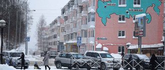
- St. Lenin . Length 14 km. Starts from the intersection with the street. Mira and Uralskaya, ends at the intersection with the street. Youth. Directly here or nearby are the city administration, banks, supermarkets and department stores, cafes, parks and squares, a museum, library, Christian temple, monuments, cultural institutions, pharmacies, a city hospital and a railway stop, some bus routes begin.
- St. Ural . The northern “border” of the business, shopping and cultural center of the city. Starts from st. Lenin, ends at the intersection with the street. Zagorodny.
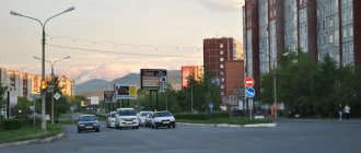
- St. K. Marx. An extended section of the route between the center of Artyomovsky and its remote area - the village. Bulanash, where the machine-building plant is located. The numbering of buildings starts from the intersection with the street. Razvedchikov (there are gas stations and cafes nearby), ends at the intersection with the street. Dzerzhinsky (next to a grocery store).
- St. Freedom . Located in the historical part of the city - Yegorshino. It is a continuation of the street. Schmidt, ends at the intersection with the street. Polarnikov. Nearby there is a railway station and a canteen, a post office, shopping centers, supermarkets, monuments, public gardens, a large green area where the Egorshinsky sanatorium is located.
- St. Polarnikov. It starts from the area of garden plots and runs parallel to the street for almost its entire length. Freedom; on the odd side there are many industrial buildings. Nearby there is a social service center, Sberbank, a household appliances store, a pet store, and supermarkets.
Post-war years
From 1946 to 1948 There was a transition of factories to the production of civilian products. So, ERZ, along with the production of radio equipment under the order of the defense industry, began to produce radio stations intended for the national economy, as well as other consumer goods. To this day, ERZ makes supplies for the defense industry, but at the same time it also produces components that are used in the automotive industry.
Artemovsky received the status of a city of regional subordination in 1960.
Artyomovsk Electric Networks (NPP) appeared in 1964.
AMZ's civilian products have become more in demand: fans produced by the plant are used in the chemical and mining industries, in mechanical engineering and energy, in metallurgy and in the construction of subways. Belt conveyors are also manufactured here and welding electrodes are produced.
1976 brought the appearance of two more enterprises in the city's economy. This is how the Artyomovsky rural construction plant appeared, which began to produce concrete building structures, which were so necessary for the national economy at that time. Now this enterprise has been renamed ZhBZ No. 1. The second enterprise was the Bulanashsky Machine-Building Plant, which began to produce pumps used for drilling rigs in the oil field.
Artemovskaya CHPP was created in 1990, taking as a basis the city production and heating boiler house and the Unified State District Power Plant, part of Sverdlovenergo JSC.
The Ural-Whitley joint venture was located at BMZ for a long time (1995-2006). Today, BMZ is a member of the Generation industrial group from the city of Berezovsky.
The municipal district "Artyomovsky District" was included in the Regional Register of Municipal Districts on November 10, 1996, and entered the Federal Register of Municipal Districts in the Russian Federation on November 30, 1999.
The gas pipeline was put into operation in April 2001.
JSC Sverdlovenergo was reorganized in April 2008, receiving the name JSC IDGC of the Urals.
Artyomovsky
(Sverdlovsk region)
OKATO code:
65202501
Founded:
1938
City since:
1938 City of regional subordination
Center:
Artyomovsky district
The city was formerly called:
| Egorshino | 1938 |
| Telephone code (reference phone) | |
| 34363***** | 32-2-22 |
Deviation from Moscow time, hours:
2
Geographic latitude:
57°20′
Geographic longitude:
61°53′
Altitude above sea level, meters:
180 Sunrise and sunset times of the Sun and Moon in the city of Artyomovsky
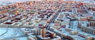
Modern Artemovsky
The Artemovsky urban district officially includes the following settlements: the city of Artemovsky; the villages of Antonovo, Bolshoye Trifonovo, Bichur, Lebedkino, Lipino, Mostovskoye, Mironovo, Pisanets, Pokrovskoye, Sarafanovo, Shogrinskoye; the villages of Buchino, Lugovaya, Lisava, Maloe Trifonovo, Rodniki, Nalimovo; villages: Bely Yar, Berezniki, Borovskoy, Bragino, Bulanash, Dalniy Bulanash, Elkhovsky, Zabolotye, Katkovy Polya, Kamenka, Kislyanka, Krasnogvardeysky, Nezevay, Sredneborovskoy, Sosnovy Bor, Upor.
The main enterprises include: Artyomovsky reinforced concrete plant No. 1, Artyomovsky machine-building plant, Artyomovskaya CHPP, Bulanashsky machine-building plant, Forestry, Egorshinsky radio plant. Food industry enterprises (including dairy, bakery and sausage factories) should also be included here. Cattle breeding (meat and dairy), poultry farming and rabbit breeding are developed in the region. The cultivation of wheat, oats, rye, barley, potatoes and various vegetables has been established.
How to get to Artemovsky
The city of Artemovsky is located 113 kilometers northeast of Yekaterinburg. To get here, you need to drive along the Rezhevsky tract, in the area of the city of Rezha, turn onto Artemovsky. There are also regular buses from Yekaterinburg. You can also get there by commuter trains (to the Yegorshino station).
Pavel Raspopov
UraloVed.ru
See also:
- Old photographs of Artemovsky
- Museum of Egorshinskaya State District Power Plant. The history of the firstborn of the Ural energy industry
- Irbitsky Written Stone
- A cave was discovered in the Irbit Pisan Stone
- Artemovsk Historical Museum
Sights of Artemovsky
The city has the Artemovsk City Historical Museum, which was founded in 1967. It hosts a historical exhibition called “Victims of political repression of the 30-50s. Artemovsky District", which was first opened back in 1990. The expansion of the museum with new exhibition and art salons took place in 1996.
Among the famous city monuments, the memorial to those killed in the Great Patriotic War of 1941-1945, the monument to Artyom (more precisely, Fyodor Andreevich Sergeev, for whom Artyom was his battle nickname), the monument to Lenin, and the monument to miners deserve special attention.
There is also a park in the city - Artemovsky City Park and Public Park.
Routes on the map of Artyomovsky. Transport infrastructure
The following regional highways pass through Artyomovsky, connecting it with the cities of Nevyansk, Rezh and a number of villages:
- Artyomovsky - Zaykovo village,
- Nevyansk – Rezh – Artyomovsky – Kilachevskoe,
- Bypass the village of Pokrovskoye from km 94+720 of the highway “city of Nevyansk - city of Rezh - city of Artyomovsky - village of Kilachevskoye”.
Railway connections:
- Station "Egorshino" - serves commuter trains and passenger trains. From here you can get to Yekaterinburg, Nizhny Tagil, Kamensk-Uralsky, Alapaevsk, etc.
- The stopping area “184 km” is located on the route of commuter trains to Kamensk-Uralsky and Reftinskaya.
Public transport - buses and minibuses. Bus routes start from the street. Lenin, from the railway station, from the thermal power plant, pass through the city and end in its remote areas or in villages included in the Artyomovsky urban district. There are regular flights to the cities of Ekaterinburg and Irbit. A map of Artyomovsky with streets will help you figure out the traffic pattern.
Churches and temples
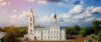
There were also churches and monasteries. In the city of Artemovsky itself you can visit the Prophet-Ilyinsky prayer house. This stone single-altar church was erected in the name of the Prophet Elijah back in 1909, so it has already passed its hundredth anniversary. During Soviet times, the temple was closed.
In Pokrovskoye there is the Church of the Icon of the Mother of God “Tenderness”. This temple is considered a temple on the blood, since the blood of martyrs was shed here more than once. Back in 1655, the first temple appeared here, then still wooden. However, just a few years later, the village was captured and plundered by nomads, and the parishioners, along with the rector, were burned in the parish building. A little later, two more churches, also wooden, were added to the temple. Only in 1821 was a stone temple built, which can be seen in our time.
The Church of the Life-Giving Trinity is located in Antonovo. It was laid in 1876 and illuminated in 1889. In 1930 it was closed. The left side chapel was consecrated in honor of St. Anthony Leokhnovsky.
In Krasnogvardeisky there is a Temple in the name of the Holy Trinity.
In Sosnovy Bor the Temple was built in honor of the Intercession of the Most Holy Theotokos.
In Mironovo, the village church is the Temple in the name of St. Great Martyr George the Victorious - is already dilapidated. The once majestic temple can now only demonstrate the bell tower and partially preserved brick walls.
In Bulanash there is a Community Church in the name of the Holy Venerable Seraphim of Sarov.
Also in the area there are many churches in a dilapidated state, and if they are not restored in the very near future, then soon these historical and cultural monuments will completely disappear.
Monuments created by nature
Natural and geographical objects do not lag behind historical and cultural ones, complementing them and glorifying the Artemovsk urban district.
So there are a lot of rivers in the area: Aramashka, Berezovaya, Bichur, Blizhny Bulanash, Bobrovka, Bolshoi Bulanash, Bulanash, Gryaznukha, Dalniy Bulanash, Elovka, Irbit, Klyuch, Krutaya, Lipovka, Maly Bulanash, Mostovka, Mezhnaya, Osinovka, Pisanskaya, Rezh , Sosnovka, Sychevka, Treasun, Khaiduk, Cheremshanka, Shaitanka, Shogrish.
In addition to the rivers, there is also Lake Beloye, which is a landscape natural monument and is therefore surrounded by a protected zone.
Kalinovsky Klyuch, which is classified as a hydrological natural monument, also has a protected zone. Pure spring water comes out here. This place is classified as a holiday destination.
The enclosure for keeping sika deer has the status of a nature reserve.
There are also open-air museums. Thus, the “Written” stone is an archaeological, botanical and geomorphological natural monument. The limestone rock located on the bank of the river is especially famous. Irbit, since it was covered with writing in several rows by ancient people. There is also a complex of rock flora, which includes the Manturov stone, which is also an archaeological, botanical and geomorphological natural monument. On the limestone cliffs there is a rocky mountain-steppe flora containing herbaceous relics and endemics.
Another hydrological and historical natural monument is the so-called “Shaitan Ditch”.
Lake Irbitskoye was connected to Shaitansky Pond by a canal, which was built on the orders of Demidov in the 18th century. serfs of the region.
Artyomovsky on the map of Russia: geography, nature and climate
Artyomovsky is located on the low eastern slope of the Middle Urals , along the right bank of the river. Bobrovki . To the west of the city there are gentle wooded hills, to the east the area resembles a plain. The picturesque surroundings attract those who like to go fishing and relax in nature. The urban area occupies 47 sq. km; a satellite map of Artyomovsky will help you get acquainted with its features.
The climate here is temperate continental. It is characterized by long winters with an average January temperature of -16°, and rather short summers with an average July temperature of +19°. Consistently frosty weather sets in by mid-November and ends in the 2nd half of March; frosts occur in May-June and August-September. The average monthly precipitation is 86 mm, the average annual wind force is 6.1 m/sec.
Written stone
The unique Written Stone is one of the most striking natural monuments. There are 70 known piston stones from the Urals, including this one. Thanks to this stone, the village of Pisanets got its name, which appeared on the territory of the Artemovsky district back in the 17th century. This natural monument is located on the left bank of the river. Irbit. A ten-meter high rock rises above the water. Its eastern side is flat, but the western side is decorated with sharp stones. And it was on the western side that, back in ancient times, people made drawings at a height of about 3 meters, but the brown ocher used has darkened so much over time that the drawings themselves are now difficult to distinguish. Here is a figure of a man surrounded by images of various animals. The largest drawing is an image of a spruce tree whose branches have drooped. These drawings are already about 2 thousand years old. At that time, this area was inhabited by the ancient Ugrians, who were the ancestors of the present-day Khanty and Mansi. Appeared in this area in the 17th century. Russian settlers called them the “white-eyed miracle”
The rock itself is composed of volcanic and bedrock, and has layers of limestone. Inside the rocks there are remains of ancient plants and animals. And the rock itself is amazing: its color in one place is completely black, and in another it is already white-pink. Well, if you touch the rock with your hand, a white trace of limestone will remain. On the side of the river at the foot there is also a small cave, the height of a person and measuring 3 by 5 meters. It is believed that ancient people could once have lived in it.
The study of drawings has also been carried out for a long time. Back in 1703, the first description appeared, made by the famous explorers of Siberia, the Remezov brothers. They had a chance to come to the Urals on the instructions of Peter I himself. In 1705, this Ural stone was also described by the scientist Vidzhen from Holland. In 1721, Tatishchev visited here, who founded the Ural mining business, as well as the city of Yekaterinburg. Academician G. Miller visited the rock in 1734, and it was his description that exactly matches the modern appearance of the stone. A.P. Karpinsky, who visited the rock in 1876, also worked on the description of the “unsolved inscription”, and in Soviet times he became president of the Academy of Sciences. Not only did he study the inscriptions, but he also collected and recorded legends associated with Pisanets N. Bulychev, who was a member of the Ural Society of Natural History Lovers. In the 20th century, the stone was studied by Professor V.N. Chernetsov, who in 1958 transcribed the remaining part of the existing inscriptions onto tracing paper. It was he who made a complete scientific description and even released an album, but the mystery of the inscriptions was still not solved. According to V.N. Chernetsov, the appearance of writings in the Urals can be associated with cyclical calendar rituals that were carried out by the Finno-Ugric peoples. These rituals were supposed to attract prey, glorify the spring revival of nature and promote an increase in fisheries to help catch more birds, animals and fish. Written sources say that the Mansi revered written rocks until the 17th–19th centuries.
At the beginning of the last century, a rich man from the village of Pisanets Uporov built a red brick house above the Pisan Stone. When the civil war was going on, rumors attributed that secret passages led from the basements of this house to the Written Stone and to the other side of Irbit. But in the 30s, Uporov was dispossessed and expelled, handing over the house to the village council. Further, this building housed an educational school.
When in 1929 the peasants on the Red Partisan collective farm needed limestone stone, they simply began to take it from the rock, thereby destroying some of the drawings. Although before development began, the rock was photographed, and the pictures were sent to Moscow to obtain permission. But since it was not possible to decipher the inscriptions, it was considered that they had no scientific significance, so development was allowed. But later it turned out that this stone was not suitable for construction, which prevented the monument from being completely destroyed. The blasting work that was carried out at that time left behind a trace in the form of large stones located on the river bank near the foot of the cliff.
Only in 1959 was the Pisany Stone declared a state reserve.
Various traditions and legends are associated with the Written Stone. So the old-timers learned that the cave was much larger; even at the beginning of the 20th century, a passage inside the rock reached all the way to the Upor station. And if near the entrance the height of the cave was only the height of a person, then further on the vaults became higher, and the cave itself expanded. In the center there was a large natural room. And just in it there was a stone dais on which stood a golden idol, the weight of which reached 12 pounds. The ancestors worshiped this idol. However, then the vault collapsed, blocking the entrance to the deep room of the cave. Also, according to the old people, the golden idol was not the only golden thing in the room, many other objects were golden. The gold grip is most often mentioned. For ancient people this place was sacred, here they worshiped their gods.
Old residents of the village Pisanets still believe that near the Pisan Stone lives a Bigfoot who is drawn to the ancient camps. So from time to time there are rumors that Bigfoot was seen nearby. So the last evidence of such a meeting was the statement of 85-year-old Nikolai Mezentsev, who saw the Bigfoot on December 20, 1991; this case was reflected in the newspaper “Artemovsky Rabochiy”, which was published on January 3, 1992.
They also say that you need to listen carefully to the rock, then you can hear a rather strange sound reminiscent of “breathing.” And no matter how they tried to destroy this miracle of nature, it survived for centuries, proving its right to surprise and delight those who saw it.
Famous personalities
The city of Artemovsky is associated with many famous personalities. So the famous “Ural Lefty” Alexander Matveevich Sysolyatin, who is a master of microminiatures, lived and worked here for quite a long time. He was given the status of an honorary citizen of this city.
The singer Tatyana Petrova, who performs folk songs, romances and Russian sacred music, comes from these places.
Also from here comes People's Artist of the Ukrainian SSR and Honored Artist of the RSFSR Eleonora Zlobina (Ellinskaya), actress of the Drepropetrovsk Opera and Ballet Theater.
Natalya Lazareva, a young writer who became famous thanks to her stories “Great Grandmother's Tales,” was born here. This author was supported not only by Ural publications, since she managed to become a laureate of the Leskov Prizes in 1993 and 1994.
Leisure facilities
Much attention is paid to organizing leisure activities for city residents. This is how children's and youth sports schools No. 25 and No. 28 operate, the sports and recreation complex "Pool", the sports and recreation complex, the Sports complex "BMZ", the ski resorts "Lesnaya" and "Snezhinka", an equestrian club and a climbing wall. In addition to encouraging sports hobbies, they also take care of cultural pastime. There are two Children's Art Schools and Children's Art School No. 24. There are branches of Ekaterinburg universities in the city. The village of Sosnovy Bor is famous for its Taly Klyuch sanatorium camp, which operates all year round. A Country health complex named after. Pavlik Morozov is considered the best camp for children in Russia.
Since 1943, the State Ural Folk Choir has been operating, which was created on the basis of the Pokrovsky amateur choir and the Izmodenovsky choir from the Beloyarsk region. In 1995, this choir received the status of an exemplary folk song and dance ensemble.