City in Krasnoyarsk Krai, Russia
| Bogotol Bogotol | |
| City [1] | |
| Bogotol railway station | |
| Flag Coat of arms | |
| Location of Bogotol | |
| Bogotol Location of Bogotol Show map of Russia Bogotol Bogotol (Krasnoyarsk region) Show map of Krasnoyarsk Krai | |
| Coordinates: 56°12'N 89°31'E / 56.200°N 89.517°E / 56.200; 89.517 Coordinates: 56°12'N 89°31'E. / 56.200°N 89.517°E / 56.200; 89.517 | |
| A country | Russia |
| Federal subject | Krasnoyarsk region [1] |
| Based | 1893 [2] |
| City status from | 1911 |
| Height | 290 m (950 ft) |
| population size (2010 Census) [3] | |
| • General | 21 051 |
| Administrative status | |
| • Subordinate | region of Bogotol [1] |
| • Capital from | city of the region from Bogotol [1], Bogotol district [1] |
| Municipal status | |
| • Urban district | Bogotol urban district [4] |
| • Capital from | Bogotol urban district [4], Bogotol municipal district [5] |
| Timezone | UTC+7 (MSK+4[6]) |
| Postal code [7] | 662060–662063 |
| OKTMO ID | 04706000001 |
| Web site | bogotolcity.ru |
Bogotol
(Russian: Bogotol) is a city in Krasnoyarsk Krai, Russia, located 6 km (3.7 mi) from the Chulym River and 252 km (157 mi) west of Krasnoyarsk, the administrative center of the region. Population: 21,051 (2010 census); [3] 24,369 (2002 census); [8] 27,752 (1989 census). [9]
Links[edit]
Notes[edit]
- ^ abcdefg Law No. 10-4765
- ^ ab Encyclopedia of Russian Cities
. Moscow: Great Russian Encyclopedia. 2003. p. 50. ISBN 5-7107-7399-9. - ^ a b Federal State Statistics Service (2011). “All-Russian Population Census 2010. Volume 1" [All-Russian Population Census 2010, vol. 1]. All-Russian Population Census 2010 [All-Russian Population Census 2010]
. Federal State Statistics Service. - ^ abc Law No. 12-2510
- Law No. 13-2868
- "On the Calculation of Time". Official Internet portal of legal information
. June 3, 2011. Retrieved January 19, 2022. - Post office. Information and computing center of OASU RPO. ( Post office
).
Search for postal service objects ( postal Search for objects
) (in Russian) - ↑
Federal State Statistics Service of Russia (May 21, 2004).
“The population of Russia, the constituent entities of the Russian Federation as part of federal districts, urban settlements, settlements, settlements of 3 thousand or more people” [Population of Russia, its federal districts, federal districts, districts, urban settlements, rural settlements - administrative centers and rural settlements with a population of more than 3,000 people] (XLS). All-Russian Population Census 2002
. - “All-Union Population Census of 1989. The current population of union and autonomous republics, autonomous regions and districts, territories, negative phenomena, urban settlements and rural district centers” [All-Union Population Census of 1989: current population of union and autonomous republics, Autonomous regions and districts , territories, regions, districts, towns and villages performing the functions of district administrative centers. All-Union Population Census of 1989 [All-Union Population Census of 1989]
.
Institute of Demography of the National Research University: Higher School of Economics [Institute of Demography of the National Research University: Higher School of Economics]. 1989 - via Demoscope Weekly
.
The city of Bogotol in the Krasnoyarsk Territory
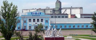
Bogotol is located in the western part of the Krasnoyarsk Territory, is the center of the Bogotol region and forms the Bogotol urban district. The Trans-Siberian Railway also passes through the city. Bogotol was founded in 1893. Initially, it was a railway station with large railway workshops. The village became a city in 1911, and already in 1925 it became the center of the region, part of the Achinsk district. The townspeople also celebrate Railwayman's Day as City Day. The population of Bogotol is more than 20 thousand people, according to 2014 studies. The maximum number of residents lived in the city in 1959 and amounted to almost 31 thousand people.
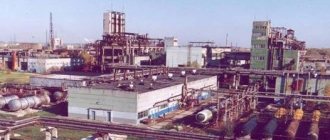
Territorial features of the city of Bogotol The Chulym River flows 6 kilometers from Bogotol, the city itself is located in the Achinsk forest-steppe along the railway. The city stands on small hills, there are many swamps in the surrounding area and there are deposits of brown coal, which prevents the growth of Bogotol. Its territory is 524 hectares. The city has well-developed railway and road transport and is connected to the Baikal federal highway. Industry of the city of Bogotol Industry of Bogotol is mainly concentrated around the railway. They repair and service locomotives here, and there is a whole factory for repairing wagons. The largest enterprise in the city is Bogotolsky Instrument, a plant producing metalwork assembly tools. In addition, agricultural products are grown and processed in Bogotol. The basis of which is grain, flax and crops for feed. They raise pigs, poultry, and rabbits. Foxes, scribes, and minks are also bred in cages. Sights of the city of Bogotol Among the attractions in the city is the Bogotol Historical and Ethnographic Museum, where you can get acquainted with the nature of the surrounding area, historical and cultural antiquities and the recent urban past. Bogotol became the first Russian city where one of the main city streets was completely illuminated with LED lights. In 2010, it became the only city in the Russian Federation with such lighting. There is a tourist club in Bogotol, which was opened in 2011. At the same time, with this club, new tourist routes were developed through the territory of the Arga reserve; rafting along the Chulym River is also carried out, and in winter skiing competitions and amateur jogging are held.
Bogotol
(Krasnoyarsk region)
OKATO code:
04406
Founded:
1893
City since:
1911 City of regional subordination
Center:
Bogotolsky district
Telephone code (reference phone)
| 39157***** | — |
Deviation from Moscow time, hours:
4
Geographical latitude:
56°12′
Geographical longitude:
89°31′
Altitude above sea level, meters:
290 Sunrise and sunset times of the Sun and Moon in the city of Bogotol
Map
| Bogotol: maps |
Bogotol: photo from space (Google Maps) Bogotol: photo from space (Microsoft Virtual Earth)
| Bogotol. Nearest cities. Distances in km. on the map (in brackets along roads) + direction. Using the hyperlink in the distance , you can get the route (information courtesy of the AutoTransInfo website) | |||
| 1 | Tyukhtet | 39 (38) | WITH |
| 2 | Nazarovo | 59 (103) | IN |
| 3 | Achinsk | 61 (67) | IN |
| 4 | Tyazhinsky (Kemerovo region) | 62 (84) | Z |
| 5 | Dubinino | 69 (204) | SW |
| 6 | Sharypovo | 76 (214) | YU |
| 7 | Big Ului | 81 (112) | NE |
| 8 | Tisul (Kemerovo region) | 89 (129) | SW |
| 9 | Uzhur | 100 (200) | YU |
| 10 | Solar | 103 (215) | YU |
| 11 | Novobirilyussy | 108 (147) | NE |
| 12 | Mariinsk | 109 (128) | Z |
| 13 | Kozulka | 115 (131) | IN |
| 14 | Verkh-Chebula (Kemerovo region) | 119 (150) | Z |
a brief description of
Located in the northern spurs of the southern part of the Arga ridge, 252 km west of Krasnoyarsk. Railway station.
Territory (sq. km): 63
Information about the city of Bogotol on the Russian Wikipedia site
Historical sketch
It arose in 1893 as a village at the Bogotol station (opened in 1898). It got its name from the village of the same name, located 8 km from the railway; the village was named after its location on the river. Bogotol. Hydronym from Ket Bogotul, where “bogotu” is the name of the Kets clan group, “ul” is “river”.
The city of Bogotol, Tomsk province since 1911.
Economy
Tool and carriage building, brewery, bakery, household goods factory, etc.
In the Bogotol region, grains, industrial crops (mainly flax), and fodder crops are grown. They raise cattle, pigs, poultry, and rabbits. Cage fur farming (fox, arctic fox, mink).
Deposits of brown coal, gold, white clay, sand, limestone, granite.
Museums, galleries, exhibition halls
Bogotol City Museum of Local Lore 662060, Krasnoyarsk Territory, Bogotol, st. 40 Let Oktyabrya, 8 Phone(s): (39157) 25-199
Architecture, sights
Bogotol is built up with multi-storey buildings.
| Population by year (thousands of inhabitants) | |||||||
| 1931 | 13.1 | 1996 | 26.5 | 2008 | 22.0 | 2017 | 20.2 |
| 1939 | 25.9 | 1998 | 26.2 | 2010 | 21.4 | 2018 | 20.0 |
| 1959 | 30.9 | 2000 | 25.5 | 2011 | 21.0 | 2019 | 19.8 |
| 1967 | 29 | 2001 | 25.2 | 2012 | 20.8 | 2020 | 19.6 |
| 1970 | 29.3 | 2003 | 24.4 | 2013 | 20.9 | 2021 | 19.2 |
| 1979 | 28.2 | 2005 | 23.2 | 2014 | 20.7 | ||
| 1989 | 27.8 | 2006 | 22.7 | 2015 | 20.5 | ||
| 1992 | 27.3 | 2007 | 22.3 | 2016 | 20.5 | ||
LiveInternetLiveInternet
Saturday, April 19, 2014 10:29 + to quote book
Bogotol is located 6 km north of the Chulym River on both sides of the railway.
The city is located in the Achinsk forest-steppe. The terrain of the city of Bogotol is characterized by slightly hilly forms, with a drop in relief observed to the northeast and southeast. Located in the center of the grain-growing region, with a developed railway junction, the city of Bogotol is a city of regional subordination and the regional center of the district of the same name in the Krasnoyarsk Territory, and is attractive for investment in its economy. The distance along the railway line to the city of Krasnoyarsk is 252 km. The main external road connections of the city of Bogotol are carried out along the federal highway "Baikal" M-53 and the regional highway Bogotol - Tyukhtet.
Coat of arms
In a scarlet field at the green end, a rising silver unicorn with golden eyes, a horn and hooves, striking with its left front hoof the rim of a golden wheel placed below on the right.
The unicorn is a historical symbol that was used on the seal of the Krasnoyarsk prison in 1644, emphasizing the special role of Bogotol in the life of the Krasnoyarsk region. A unicorn resting on a wheel symbolizes the importance of the Bogotol transport hub for the economy of the entire region.
The unicorn is a traditional symbol of strength and invincibility, prosperity, prosperity, and life-giving energy.
The wheel is a symbol of forward movement, development, tirelessness; in the city’s coat of arms it also symbolizes a transport hub.
Gold is a symbol of respect, intelligence, wealth, stability.
Silver is a symbol of purity, perfection, peace and mutual understanding.
Scarlet (red) color is a symbol of courage, strength, labor, beauty.
Green color is a symbol of nature, health, vital growth; the city's coat of arms emphasizes the fertility of the Bogotol land.
The city of Bogotol (translated from the Turkic language - small valley) received its name from the village of Old Bogotol.
The settlement has been known since quite ancient times. A trade was established in the local village, which supplied workers in the gold mines with everything they needed. In addition, there was also a station for exiles, as well as their settlements. The nearby highway, which connected almost all of Siberia, had a great influence on the development of the village. The legend about the elder Fyodor Kuzmich is associated with the Bogotol land. It was here that this mysterious character lived, in whom many see the abdicated Emperor Alexander I.
The construction of the railway brought new life to this village. In 1893, Bogotol station was founded. Since 1911, Bogotol has become a city. Large railway workshops are being created along with the station. They employed a large number of fairly qualified workers, so the Russian revolutions were met here with understanding and approval. During the Civil War, local residents mainly supported the Bolsheviks. Red Guard detachments and several partisan brigades were created to fight the Czechoslovak corps and White Guard units.
In the 1920-1930s, the station grew and new production areas were created. During this period, Bogotol was a major commercial and industrial center. The first “legends” appear - machinists and railway workers, awarded the highest awards for their dedicated work.
In the period 1941-1945, thousands of conscripts left Bogotol for the front. Many of them died or went missing, many returned. Among the natives of Bogotol there is a front-line soldier awarded the title Hero of the Soviet Union.
After the Victory, Bogotol is actively developing. A carriage repair plant and the production of metalworking tools are being built, and the agricultural industry is being actively developed. The city is becoming a major railway junction, which cannot but influence its development.
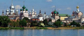
Among the attractions are a temple built in 1988, a monument to a steam locomotive, as well as a monument to fighters for the cause of the revolution. There are memorials to participants in the Great Patriotic War and those who died from wounds in the Bogotol hospital. The city has a historical and ethnographic museum.
The modern city of Bogotol is one of the large railway junctions of the Krasnoyarsk Territory; numerous railway services are located here: a locomotive depot, a carriage depot, a track distance, a communication distance, a power supply section.
| Categories: | Cities of Russia/Starting with the letter *B* |
Cited 1 time
Like share
0
Like
- I liked the post
- Quoted
- 0
Saved
- Add to quote book
- 0
Save to links
Liked
0