Kimry on the map of Russia: geography, nature and climate
Kimry is located east of the regional center, 100 km from the capital of Russia. The settlement was built where the Kimrka River flows into the Volga . The relief features within the city are due to its location in the Upper Volga lowland . The height of the area above sea level is 100-130 meters. Swampy, podzolic and floodplain soils predominate.
Kimry is a typical city with a temperate continental climate. Summers in these parts are cool and humid, winters are quite long and cool. In July, the warmest month of the year, the average air temperature is around +18.7 °C; in February the air cools down to −7.6 °C.
Looking at the map of Kimry from a satellite, one cannot help but notice that the city is surrounded by forests. Both coniferous and deciduous trees grow here. Hares, foxes and raccoon dogs are found in the forests. Beavers live in rivers.
Private advertisements in Kimry, in the Tver region and in Russia
To add an advert
Tver
Installation of a water purification system. Water supply
Tver
We will install all types of doors and partitions
Tver
Maintenance, installation of networks, computers, SCS, LAN. IT Outsourcing
Tver
Private welder in Tver
123ru.net
- minute-by-minute news with a daily archive. Only here we have all the main news of the day without political censorship. “123 News” - absolutely all points of view, sober analysis, civilized debates and discussions without mutual accusations and insults. If you don’t like it, don’t want to hear it, don’t read it, read it, be mutually polite and correct in your statements. Remember that not everyone's point of view coincides with yours. Respect the opinions of others, even if you defend your views and your position. 123ru.net is a news observer. We do not impose our vision on you, we give you a snapshot of the events of the day without censorship and without cuts. News as it is—online with minute-by-minute archives for all cities and regions of Russia, Ukraine, Belarus and Abkhazia. 123ru.net - live news live! A quick search from 123ru.net is not only the opportunity to be the first to know, but also the advantage of reporting breaking news instantly in any language in the world and being heard right away. You can add your news at any moment - here.
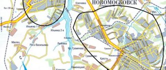
Routes on the map of Kimry. Transport infrastructure
You can get to the city of Kimry both by land and by water.
Railway transport
On the right bank of the Volga, in the Savelovo area, there is a railway station in the city of Kimry (Tupoleva St., 1, Kimry). Trains running on the Moscow-Uglich route stop here. You can also travel from the capital to Savelovo by train.
Automobile transport
The highway 28K-0713 (Dubna-Kimry-Goritsy) and the highway 28K-0733 pass through Kimry, which can be reached through the city of Taldom, following from Moscow along the A-108 , then turning at Zhestylev onto the P122 .
River transport
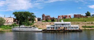
Kimry is one of the stops on the routes of cruise ships plying along the Volga .
Urban transport
You can get to any part of the city by bus.
1.5 km from the city, near the village of Kletino, there is the Borki sports airfield, offering familiarization flights over Kimry.
City `s history
The city was first mentioned as the palace village of Kimry in 1546, in a charter of Ivan the Terrible.
In the XVI-XVII centuries. Residents of the village of Kimry were engaged in shoe production and trade. Until 1677 the village was under the jurisdiction of the Great Palace; then it belonged to the Saltykovs, Skavronskys and Samoilovs. In 1847, the residents of Kimry bought their freedom from the land from Countess Yu. P. Samoilova. Initially, the village had the name Kimra, and much later, under Soviet rule, it was renamed the city of Kimry
In 1978, the Verbilki-Savelovo section was electrified, which made communication with Moscow by electric trains possible. Further Savelovo movement is carried out on diesel traction. Long-distance communication is provided with Moscow, Rybinsk, Vesyegonsk and Pestovo. Suburban communication by electric trains is carried out with Taldom, Dmitrov, and Moscow. Suburban service has been organized with Kalyazin, Uglich, Kashin, and Sonkovo by “working” trains with diesel traction.
For a long time, the Savelovo station was used for transshipment of cargo onto flat-boats, where they were transported along the Volga to Rybinsk and then transferred to barges. Since 1940, after the implementation of the “Big Volga” master plan as a result of the construction of the Ivankovsky, Uglich and Rybinsk hydroelectric complexes, the Volga became navigable to Tver and the need for transporting large cargo along the Savelovskaya branch disappeared.
Kimry is the birthplace of the writer Alexander Fadeev, the village of Pustomazovo, Kimry district, is the birthplace of the Soviet aircraft designer Andrei Tupolev. In 1939, the poet Osip Mandelstam was exiled to Kimry (Savelovo) on the eve of his arrest and sending to a concentration camp.
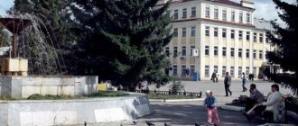
Sights of the city of Kimry
- You can find out more about the history of the city by visiting the Kimry Museum of Local Lore .
- The monument to the Kimry shoemaker reminds of the past of the settlement .
- In honor of the soldiers who died in battles with the Nazis during the Second World War, a bayonet-shaped obelisk .
- The exhibitions of the District House of Crafts and Folklore will tell about the culture and life of the peasants who lived in these places several centuries ago .
- Noteworthy examples of religious architecture in the city of Kimry are the Transfiguration Cathedral and the Church of Our Lady of Jerusalem .
- Cultural leisure for residents and guests of the city is provided by the Kimry Drama Theater .
“I measured it, I made a miracle...”
If you are interested in the toponymy of Russia, then you probably noticed that most toponyms and hydronyms are attributed to the chronicled Merya tribe. I suspect that this is being done in order to write off attempts to decipher the names of cities and other villages using the Russian language. As a rule, these attempts lead to unmotivated translations. And with the measure - what beauty! It is believed that this people disappeared in the Slavic colonization flow. And if so, Meryan words can be designated untranslatable with a calm research soul. But there is a nuance: many researchers of the 18th and early 19th centuries wrote that the Merya did not disappear anywhere, but lives where it lived for hundreds of years. The Merya calls itself Mori, and the Russians call this Mori Mordovians.
Main streets of the city of Kimry
On the map of Kimry with streets, the main arteries of the city are clearly visible:
- st. Uritsky
- st. Ordzhonikidze
- st. Volodarsky
- st. Vagzhanova
- st. Karl Liebknecht
- st. 50 years of the Komsomol
- st. Chapaeva
At the entrance to Kimry, Ilyinskoye Highway turns into Uritsky Street , which stretches to the Volga River. Following Uritsky Street, you can see the city bus station, the Transfiguration Cathedral, and the Kimry District Administration building.
Ordzhonikidze Street runs along the left bank of the Volga. Near the street there are South Square, Molodezhny, and the Maltsevsky Bor green area.
Volodarsky Street is also laid along the left bank of the Volga . While walking along it you can see Theater Square and the Kimry Drama and Comedy Theater, the city park and the Zvezda stadium.
Vagzhanova Street crosses Uritsky Street and runs perpendicular to it. Near Vagzhanova Street there is a city hospital and a cultural center of the factory named after. Gorky.
Karl Liebknecht Street runs parallel to the Kimrka River. There are several green areas along this street.
50 Let VLKSM Street runs between the Volga and the railroad tracks on the right bank of the river. Not far from the street there is a monument to the residents of Kimra who died a brave death during the Second World War, a monument to Afghan soldiers, and a monument to military personnel who died in the North Caucasus.
On the right bank of the Volga there is Chapaeva Street , next to which the hospital and the 40 Let Oktyabrya Palace of Culture are located.
Kimry as a toponymic riddle
I remember back in the 70s they gave me luxury sneakers with the name “Kimry” on the soles.
The sneakers were comfortable and lasted a long time. But I still remember how surprised I was by the wonderful name - Kimry. And, apparently, I was not the only one surprised by this name. Even the great Tatishchev in the 18th century drew attention to the name of the shoemaking capital of the Russian Empire:
Is this name Estonian, Mordovian, it means bearish - as in Estonia there was the city of Kirempe, in Russian - “Bear’s Head”. Kirema is a river flowing into the Volga, in Russian - Medveditsa. Maybe the Kimrys themselves were called Kirems.
The Wiki says the following about the name:
There are several versions of the origin of the city's name. Among local historians, the possibility of the origin of the word “Kimra” (“Kimera”, “Kimerya”, “Kimer”) from the name of one of the Finno-Ugric tribes - Merya is being considered. The Meryans lived in the Upper Volga region and the Klyazma River basin on the territory of modern Yaroslavl, Ivanovo, in the northern and central parts of the Vladimir, northern and eastern parts of the Moscow, eastern part of the Tver, southern part of the Vologda and western part of the Kostroma regions of Russia.
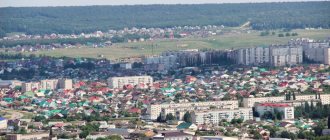
Kimry today
The city of Kimry is located on both banks of the Volga River. It owes both its origin and its further development to it. Currently, there are transit and intra-city berths in Kimry. On the left bank, the city center is now located. Many ancient buildings have been preserved here, most of which are architectural monuments. The Savelovo microdistrict, located on the right bank of the Volga, is predominantly built up with more modern houses.
The banks are connected by a large bridge across the Volga, built in the early 80s and restored in the 21st century. Until this time, the crossing was carried out using passenger and cargo ferries. There are roads leaving the city in three directions. The ancient Ilyinskaya road through Goritsy leads to Tver and Kashin. You can get to the capital along the Moscow road through Dubna and Dmitrov. The Taldom road leads to Bely Gorodok, Taldom, and Kalyazin. You can also get to Dubna and further along the local road leaving from Savelovo station.
The city of Kimry is surrounded by both large and small settlements. There is a regular bus service between the city and most of them. Kimry is connected by bus routes to the cities of Tver and Moscow, the distance to which is 135 and 150 km, respectively. In addition to buses, Kimry is also connected to Moscow by the Savelovo railway station. You can find out the schedule of buses and electric trains in the main section of the site.
Long-distance communication is provided with Moscow and Rybinsk. Suburban communication by electric trains is carried out with Taldom, Dmitrov, and Moscow. Suburban service has been organized with Kalyazin, Uglich, Kashin, and Sonkovo by “working” trains with diesel traction.
Kimry is a port city on the Volga, and 15 km downstream in Bely Gorodok there is a large ship repair enterprise.
The area of the city of Kimry is approximately 43.6 square kilometers, of which 4.4 square kilometers are occupied by household plots of citizens, and 3.4 by collective gardens.
Today, according to the 2010 All-Russian Population Census, 49 thousand people live in the city.
Kimry is the largest industrial center in the region. The city's industry is represented by various sectors. The main ones are mechanical engineering (machine tool building, aircraft factories of the military-industrial complex), light industry (clothing, shoe industry and furniture production) and food industry. The region's economy employs more than 26 thousand people.
Meat and dairy cattle breeding and pig breeding are developed in the Kimry region. Potatoes are grown.
The city has a mechanical and technological college, a medical school, and a branch of the university.
City of Kimry. origin of name
Merya is Mordvinian. Well, or people close in culture and language to Moksha and Erza. If so, then the “untranslatable” Meryan toponyms and hydronyms should be somehow motivated to be translated using, for example, the Erzya language.
Let me emphasize : motivated means reflecting a certain physical reality associated with the specifics of a particular area or craft.
In the case of Kimry, we are dealing specifically with the craft activity of the city residents - the production of boots. But then it turns out that neither the Cimmerians nor the other Krivichi have anything to do with the word “Kimry”. More precisely - Kimra.
Pay attention to the end of the word - Ra. In Mordovian languages, Ra is the name of the Volga River. Sometimes they say Rav or Rava, that is, Mother Volga.
What is “Kim”? Let us assume that Kim is the word Kem, modified during oral transmission, that is, “boot.”
It turns out that Kimry - Kimra - Kemra are “Volga boots” or “boots from the Volga”.
A clearly motivated and logical translation of the name of the Russian shoemaking capital. Kimra - Volga boots. I think it's cool! And what do you think?