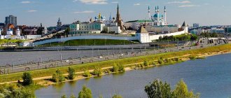
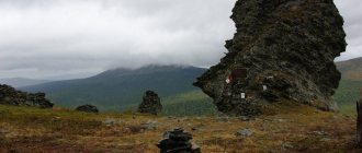
Adygea is one of the most beautiful regions, which is rightfully proud of its history, culture and natural monuments. It is located within the territory of the Krasnodar Territory and borders this region on all sides. The most beautiful miraculous places of Adygea, captured in the photo, have long become the hallmark of the republic. Fossilized remains of marine life are often found on its territory, and this is not surprising, because once upon a time, millions of years ago, the entire territory of Adygea was the seabed.
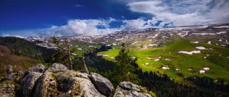
Here forest-steppes give way to oak forests and beech-fir forests. The landscapes are stunning, and the diversity of water resources is simply immeasurable. The water in mountain rivers, lakes and waterfalls is so clean and transparent that you can see everything that happens in the underwater world. One of the most famous places in Adygea created by nature is the Lago-Naki plateau, through which all tourist routes pass.
Lagonaki Plateau (Lago-Naki)
The plateau with an area of about 800 square meters is located in two regions at once: Adygea and Krasnoyarsk Territory. Once upon a time, a trade route connecting the North Caucasus and the Black Sea coast passed through it.
Today, tourists can admire the pristine nature of this place: rich vegetation, unique topography, breathtaking views and stunning glaciers. Landscapes from lush greenery to cold ice can change quite quickly in a short period of time.
There are many caves in this area, the deepest of which is the “Soaring Bird”, which goes 517 meters deep. And here the sites of ancient people and traces of massacres between the Tatars and mountain tribes were discovered.
The importance of the city in the modern world
The Myekuape tract (“Apple Valley”), the old name of Maykop, was first mentioned in documents in 1825, but archaeological finds claim that people lived in these fertile places 50 centuries ago.
It is reliably known that in the 7th-10th centuries the Great Silk Road passed here, and the finds in the mound of the leader-priest Oshad, which shook the entire scientific world, told about the life of the ancient Scythian and Sarmatian tribes in the North Caucasus. The Adygeans founded the city of Temryuk in Taman, naming it after the Kabardian prince.
Neighboring Russian settlements, local tribes repeatedly turned to the help of Russian weapons in defense against foreign invaders. And in the 50s, XVI Ivan the Terrible, having married the prince’s daughter Maria Temryukovna, annexed the mountain lands to Russia, leaving the people’s right to independence. Thus began the history of Adygea as a part of Russia.
At first, Maikop was created as a fortification in the Caucasian defensive line; this happened in 1857 under the leadership of General V.M. Kozlovsky. But with the end of the war in the Caucasus, it lost its significance, and peaceful life began in the village. The settlement was recognized as a county town in 1870.
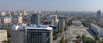
Today Maykop is a fairly large city, covering an area of about 70 km2, the industrial capital of the republic, where 60% of mechanical engineering, woodworking and food industry enterprises are concentrated. The city is known throughout the world for its unique archaeological finds, which are studied and stored in the country's largest museums.
Mount Fisht
The ancient Adyghe people named the highest mountain on the Lago-Naki plateau in honor of the gray-haired warrior Fisht, who, according to legend, saved his people from enemies. Its height is 2868 meters and climbing to the top shrouded in clouds is a rather difficult and dangerous undertaking. Those who reach the goal discover the wonders hidden within the mountain, nicknamed Treasure Island.
The territory of Adygea was once the seabed and confirmation of this is the coral island that has preserved the fossilized flora and fauna of the ancient Tethys Ocean.
One of the highest waterfalls in Russia - Pshekhsky - is also located here, its height is 250 meters.
Parks and Recreation
Fantasy Park
Cost: 70 rub. for adults, 40 rub. for children How to get there: from Maykop in a southerly direction (to Guzeripl), 6 km from the village of Dakhovskaya
A theme park in the Mountain Village tourist complex, Nikel village, founded by writer and honored tourist Nikolai Bushnev. Its full name is the Park of Fantasies and Jokes, and the exhibits are original wooden and stone sculptures.
On the territory there are historical pavilions (“Ancient Russian hut”, “Cossack courtyard”, “Dwellings of nomadic peoples”, etc.) and a gallery of applied art.
Thermal spa center Kedrovy Bor
Address: r. Adygea, Tsvetochny village, st. Shkolnaya, 16 A Telephone: Opening hours: daily 09:00-22:00 How to get there: the village of Tsvetochny is a 30-minute drive from Maykop
The recreation center and thermal spa center is located in the village of Adygea on natural springs rich in silicon, sulfur and other useful microelements. The center is equipped with everything necessary for comfortable relaxation and treatment: locker rooms, gazebos, cafes, a children's area, and sources of healing drinking water.
Water Riviera: thermal spring
Address: r. Adygea, Tula village Telephone: Opening hours: daily 9:00-22:00 How to get there: 15 km from Maykop along the Maykop-Guzeripl highway
The hot springs and center of the Water Riviera are located near the Lago-Naki plateau and the Caucasian Biosphere Reserve. They are used to treat various diseases and general health. The infrastructure includes 5 swimming pools with water of different temperatures, a children's pool, cottages for guest accommodation, and a cafe.
Rafting workshop – Rafting and kayaking on the Belaya River
Address: r. Adygea, Khamyshki village, st. Mira 20A Phone: + Website: https://masterraft.ru Cost: 1000-1800 rub.
Rafting and kayaking on the Belaya River is entertainment for lovers of active recreation. The adventure is well organized and as safe as possible, and different levels of difficulty provide the opportunity to experience incredible emotions for both beginners and experienced rafters.
Devil's Gate Pass, Mount Acheshbok
The composition created by nature, consisting of two mountains, captivates with its appearance and intriguing name. The fact is that the mountain peaks curved towards each other look like the devil’s horns, as they are depicted in fairy tales, and griffon vultures nest in the rocks of Acheshbok - representatives of the family of birds of prey, listed in the Red Book.
Local residents can tell many legends associated with this place. According to their custom, they call the Western and Eastern Acheshbok mountains the Right and Left Gates. In ancient times, the route to high mountain pastures passed through the Devil's Gate pass. Thanks to frequent grazing of livestock, a small passage was created under the pass, which local residents immediately named the Devil's Gate.
Museums and buildings
National Museum of the Republic of Adygea
The museum moved to Maykop in 1936 from Krasnodar. At the time of the move, the collection consisted of 2,000 items related to the history and culture of Adygea. Now it contains 270 thousand exhibits, including memorial complexes, art objects, dishes, coins, sculptures and others. They represent not only Adygea, but also other Caucasian republics.
This is the only museum in the country that tells about the life of the Adyghe diaspora. There is a cinema hall and a scientific library on site, and lessons and excursions are held. In the museum you can visit exhibitions telling about the Russian-Caucasian wars.
The National Museum of the Republic of Adygea participates in the “Night of Museums” event.
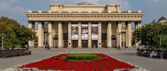
Republican Chamber Musical Theater
The theater began its work in 1993, taking the name of its founder A. A. Hanahu. At first, one could see works by local composers, as well as Russian and foreign classics.
A turning point in the fate of the theater was the production of the operetta “Jeanne Cries, Jean Laughs” by Jacques Offenbach. After that he became popular.
Now here you can see the operettas “Silva” (I. Kalman), “Die Fledermaus” (I. Strauss), “My Fair Lady” (F. Lowe), musical comedies “The Beautiful Helena” (J. Offenbach), “Ladies and hussars" (A. Fredro) and other famous works.
Art Gallery
The gallery opened its doors in 1980. It is small, consisting of only two rooms. One contains a stationary exhibition introducing the culture of the Adyghe people. The second hosts exhibitions of contemporary Caucasian artists: A. M. Kuanova, A. M. Bersirov, F. M. Petuvash, M. G. Tuguza, T. M. Kata, Yu. G. Kirichenko, A. V. Egorov, A. V. Rezyukina.
Cathedral Mosque
Address: st. Sovetskaya, 200. Ost. “Friendship Square”Phone: 8 (872) 257-05-48 Opening hours: 8:00 - 24:00 (Mon - Sun) Cost: free
The mosque was built in 2000. Construction lasted only 1.5 years. The sponsor of the work was Sheikh from the UAE Khalid Bin Saqr al-Qassimi, whose mother was Circassian. Here is the residence of the Spiritual Administration of Muslims of Adygea and the Krasnodar Territory. The interior walls are decorated with quotes from the Koran. The mosque includes:
- ablution room;
- women's room;
- library.
Unlike most mosques, Sobornaya can be visited by representatives of other religions. In this case, it is necessary to follow the established rules:
- You must take off your shoes before entering;
- It is allowed to take photographs inside, without forgetting the feelings of believers.
White River (Shaguashe)
The Belaya River originates from the snow-capped peaks of Mount Fisht. Having made its way through the rocks, the water stream made its way through mountains, valleys and forests.
Along the entire length of the river, which is more than 260 kilometers, the nature of the flow changes all the time. In the valleys it is calm, in the mountains it is swift, and in the forests it is moderately fast.
The Adyghe name of the white river is Shkhaguashe. That was the name of the princess whom her father wanted to force into marriage, but she was able to escape. There are many legends about why the river is called Belaya. According to one version, it got its name in honor of Bela, a young Georgian captive whom the Abadzekh prince wanted to marry. The servants threw her into the water because she had stabbed their master.
Sights of Guzeripl
There are not many attractions in this village, but they still exist.
Where to stay in Guzeripl – here.
Museum of the Caucasian Biosphere Reserve
The museum complex was created in the mid-fifties of the last century. The exposition is more than interesting. This uses an approach that is used quite rarely. These include high-quality photos of the biosphere reserve and stuffed animals. Moreover, the stuffed animals do not stand on pedestals, but are placed in the environment in which they live. Another difference of the complex is that it operates year-round, without days off or breaks. Read more…
Guzeripl dolmen
This is the largest dolmen in Adygea, and possibly in the whole world. It is located on the territory of the Caucasian Biosphere Reserve and, in fact, is one of its local attractions. Not so long ago, the entrance to the dolmen was free. But some time ago he was taken into protective custody. After all, everyone knows the desire of some unscrupulous tourists to sweep away everything in their path, or to get into where they shouldn’t.
More information about the dolmen GPS coordinates: 43°59'56.0″N 40°08'12.5″E To see the dolmen, you will have to pay 300 rubles to enter the reserve. For this money, you will visit the biosphere reserve named after. Shaposhnikov, you will visit the museum; for an additional fee, you can actively spend time in the rope park.
Large and small observation platforms of Guzeriplya
There are several observation platforms here, but hiking trails are well paved only up to two. The small observation deck is located on Mount Chernaya. The rock has a slightly cut surface, densely covered with vegetation. Here you can enjoy all the splendor of the seething Belaya River, on the eastern side of the village. The large observation deck is located a little higher than “Malaya”, on a rocky ridge resembling a rooster’s comb. More details, map, GPS coordinates
Polyana Yavorova
A very beautiful place, named after the majestic broadleaf maple. The most interesting thing is that you can enjoy the beauty of the surrounding nature and unique views at any time of the year. In summer, tourists successfully camp here with their tents. And in winter they go skiing. Where it is interesting, fun and active to spend time enjoying the snow-capped mountain peaks. Read more…
Rufabgo Falls
Picturesque waterfalls are located in the gorge of the Rufabgo River, which flows into the Belaya River. They are strikingly different from each other, but together they form a unique composition and each has its own name.
“Cascade” is called so because the water falls over 3 cascades.
“Heart of Rufabgo” got its name because of the stone in the shape of a human heart, from under which a stream of cold water rushes.
The highest waterfall is called “Lace” or “Maiden’s Braid”, its length is 20 meters. The flow at the Maiden's Braids waterfall is divided into three streams, which look like 3 strands of hair intertwined into a braid.
In “The Cup of Love,” streams of the purest water seem to flow into a stone container from a height of five meters.
Lake Psenodakh
A characteristic feature of Adyghe lakes is their ability to appear and disappear according to unknown laws of nature. One of them is Lake Psenodakh in the shape of a crescent 165 meters long. It is located on the site of an old glacial bowl at an altitude of 1938 meters and is fed by streams and springs flowing through underground channels.
The unusual name is translated from Circassian as “beautiful well”, and from Adyghe – “beautiful lake”. Its maximum depth reaches only 80 centimeters, and the water is so clean that the smooth surface of the lake looks like a polished lens. Sometimes you can see turbulence on the water surface of the lake when the water begins to go into underground channels.
Rivers, lakes and attractions on rivers in Adygea
Rufabgo waterfalls One of the most picturesque attractions of Adygea is the Rufabgo waterfalls near Kamennomostsky. There are 10 waterfalls in total, but the most colorful are the Noise, Cascade, Heart of Rufabgo, Lace, Bowl of Love and Maiden Braids waterfalls. Read more…
Khadzhokhskaya Gorge The visiting card of the village of Kamennomostsky in Adygea is the Khadzhokhskaya Gorge. In this place, the Belaya River flows through a narrow and deep canyon. For several years now, the attraction has been an equipped excursion site. Read more…
Granite Canyon, Granite Gorge South of the village of Dakhovskaya there is the well-known Granite Canyon in Adygea. The length of the Granite Gorge is 4 km, and the depth is 200 meters. Areas with rapids are very common in the Granite Gorge; this place is ideal for rafting. Read more…
River and gorge Meshoko (Mishoko) The river and gorge Meshoko amaze tourists coming to Adygea with their unique, mysterious beauty, waterfalls and grottoes. Getting into the gorge is not at all difficult; there are several paths of varying difficulty leading into it, incl. and from Kamennomostsky. Read more…
Sakhray waterfalls, Sakhray river Famous sights of the Sakhray river are located along the river between the villages of Novoprokhladny and Ust-Sakhray. Sakhrai waterfalls are beautiful and always full of water, but usually low: Mankin Shum, Mamryuk, Soldatsky, Razlom, Canyon, Triple Fault. Read more…
Belaya River The Belaya River is the largest aquifer in Adygea and is one of the most powerful left-bank tributaries of the Kuban. The length of the river is more than 260 kilometers. The upper reaches of the Belaya River are fed by mountain streams and springs of Fisht, Oshten and Abago. Read more…
Valley of the Ammonites Valley of the Ammonites (Adygea) is a unique natural monument located in the valley of the Belaya River. The length of the valley is large: the attraction begins at the Khadzhokhskaya gorge (Kamennomostsky village), follows downstream the Belaya, and ends at Abadzekhovskaya. Read more…
The Kishi River (Kisha), Kishinsky Rapids The Kishi River is covered in rumors and legends, attractive and merciless attracts tourists to its waters. At the confluence of the Belaya and Kishi rivers, a rocky gorge has formed, the river bed is cluttered with boulders, the Belaya River forms the Kishinsky rapids. Read more…
Pshekhsky waterfall, Vodopadisty stream At the right tributary of the Pshekha river, at the headwaters of the Pshikhashkhi river, the Pshekhsky waterfall originates, the height of the cascades of which reaches 165 meters and 160 meters. In summer, the Pshekhsky waterfall is relatively shallow, but no less attractive for tourists. Read more…
Lake Psenodakh The largest lake in the Fisht-Oshtenovsky mountain cluster is Lake Psenodakh, reminiscent of a crescent. Lake Psenodakh is located at an altitude of 1938 meters above sea level. The length of the lake is 165m, the width at its greatest point reaches 72m, the depth generally ranges from 20 to 80cm. Read more…
Fars River The Fars River, a left tributary of the Laba River, flows through the Krasnodar Territory and Adygea. The length of the river is more than 190 kilometers, and there are large villages on it. The Fars River originates from a spring a few kilometers from the village of Pobeda. Read more…
Dakh River The Dakh River, or Dakhe, is the right tributary of the Belaya River. The length of the Dakh River is 23 kilometers. Its main tributaries are Shushuk and Sakhray. There are 2 large settlements on the river: the village of Ust-Sakhray and the village of Dakhovskaya, as well as Bukreeva Gorka. Read more…
Polkovnitskaya River, Polkovnitskaya Balka The Polkovnitskaya River, also known as Polkovnitskaya Balka or Polkovnitskaya Balka, is a left tributary of the Belaya River. It is famous not only for military events, but also for a large accumulation of unique marine mollusks - ammonites and belemnites. Read more…
Aminovka River, Aminovka Gorge The Aminovka River is a left tributary of the Belaya, begins on the watershed ridge of Kurdzhips and Belaya. The length is more than 9 kilometers, and 8 of them the river flows through the Aminovsky gorge, and the remaining route along Kamennomostsky, to the place where it flows into the Belaya River. Read more…
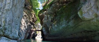
Khadzhokh Gorge (Tuapch Canyon)
This attraction is unique for its unique topography, unpredictability of water and dangerous steep cliffs. Tesnina is located in the southwest of the village of Kamennomostsky, which is also called Khadzhokh.
The gorge is a rocky gap through which the Belaya River flows. Its length is 400 meters, and its depth in some places reaches 40 meters. Due to the very strong noise that occurs as a result of constant collisions of water flows with stones and ledges, the gorge is called Noise.
Tuapch Canyon is also one of the symbols of the gorge on maps. While walking through this amazing and picturesque area, tourists are treated to beautiful views of the fast-moving river, beating against rapids and centuries-old boulders.
Tourist shelters and camps of Adygea
Partizanskaya Polyana The route to the Partizanskaya Polyana, and from it to Mount Fisht and the Lagonaki Plateau, is one of the most popular routes, starting in the village of Guzeripl in Adygea. It is located at the foot of the Stone Sea ridge, at an altitude of 1600 meters above sea level. Read more…
Yavorovaya Polyana 6 kilometers from Partizanskaya Polyana at an altitude of 1575 meters is Yavorovaya Polyana. The asphalt road from Guzeripl ends here. The clearing got its name from the sycamore tree that grows here – the broad-leaved maple. Read more…
Tour shelter Fisht Tour shelter Fisht is located on the territory of the Caucasus Natural Biosphere Reserve, between the Belorechensky and Armenian passes in a picturesque clearing along which the Belaya River flows, and on the north-western side are the peaks of Fisht and Oshten. Read more…
See also the sights of Kamennomostsky and the sights of Maykop.
Granite Canyon (Blockhouse Gorge)
The canyon appeared literally by the will of nature. Many years ago, powerful streams of the Belaya River began to cut stone blocks and turned the entire massif into an amazing and colorful natural monument.
Lush green vegetation hanging over the abyss against a background of bright red stones - this place seems to have been painted by an artist. The rocky hills are covered with a green carpet, “woven” from various types of trees: chestnuts, barberries, pines and beeches.
On the right bank of the canyon there is the Zolotoy spring, from which the stream of the same name flows, and it is named so for a reason. Once upon a time, local residents panned for gold here, and the places where the stream flows were the most profitable for mining.
Khadzhokhsky quarry
This quarry was once a thriving mining operation for limestone, selenite, yellow-white gypsum and small calcite crystals. Now here you can see the remains of a once thriving industry overgrown with grass.
Not far from the quarry there are dilapidated buildings with pipes. These are old lime kilns. Nearby there is a new mobile plant for processing rocks mined in the vicinity of the village of Kamennomostsky.
At the very bottom of the quarry there is Lake Krasnoe, fed by springs. The reservoir got its name because of the reddish hue of the stones. The water in it is always cold, but at the same time very clean, despite its cloudy color.
Great Azish Cave
This attraction is located in the southern part of the Azish-Tau mountain range in the Krasnodar Territory, but it is always associated with Adygea due to its close location next to the official border of the regions.
The cave officially became a natural monument only in 1973. Its length is 690 meters, and its depth is 37 meters. Traveling through the corridors of the cave, you can endlessly admire the stalactites, stalagmites, sintered forms and columns.
Some of them have their own names, for example, the “Sword of Damocles” - a stalagmite in the shape of a real sword hangs menacingly from the ceiling, and the “Wish Palm”, which grew in this cave, is no different from a real southern tree.
Thermal springs: Adygea - health resort
If the purpose of the trip is not only to see the sights of the region, but also to improve your health, then you should definitely go to the thermal springs. Adygea is famous for them far beyond Russia.
- One of the popular places is the balneotherapy hospital located in Maykop. Not far from the complex there are iodine-bromide thermal springs. The hot key has a temperature above +40 degrees. Water does not freeze in winter.
- There are also springs near the villages of Tsvetochny and Tulskiy . The properties of water are unique. It is really very healing: there is a lot of silicic acid in the bicarbonate chloride-sodium composition.
Important! Doctors warn that one should not dive headlong into thermal springs, the hot springs of which are healing and beneficial, but only after the approval of the attending physician. You should not self-medicate.
Now everyone and their family can choose what to see in Adygea on their own by car. The trip will be interesting and exciting for everyone, and the amazing nature of the region will give inspiration and allow you to take a break from the bustle of the city.
For cultural lovers, there is also a whole list of museums and outdoor attractions. For children there are play complexes and other entertainment according to age. Well, family walks in the mountainous areas will leave unforgettable impressions for a long time. You will want to return to Adygea again and again.
Cave Through
According to legend, the evil giant Rufabgo lived in this cave and, looking at its gigantic size, I want to believe it. You can find it near the Shum waterfall in the valley of the river named after the giant.
The cave got its name “Through” because of its elongated shape and the presence of two exits on the north and south sides. Having a length of 25 meters, it is sufficiently well ventilated, preventing the formation of leaks.
Thanks to the karst hole at the top of the cave, it is quite light inside during the day and you can walk through it even without being an experienced speleologist. The hole in the hole is shaped like an eye, and the back wall of the rock is hidden under Colchian ivy.
Dolmen Hadzhokhsky
The Khadzhokh dolmen is one of the most mysterious archaeological sites in Adygea. Scientists still do not stop arguing about the purpose of these buildings. Some claim that they were used for rituals and burials, others believe that these are the first residential buildings of ancient people who inhabited the area thousands of years ago.
You can find the Khadzhokhsky dolmen in the north of the village of Kamennomostsky. Its height reaches 1.7 meters and width – 2.8 meters. This structure was approximately built in the 3rd century BC.
Next to the dolmen there is another unusual phenomenon of local nature - a tree with 14 trunks from one root.
A little about Adygea
Adygea
Adygea is a year-round region, a close neighbor to the Krasnodar region. There is no sea here, but the mountains and mountain rivers delight the eye, which you can study and admire for a very long time. In winter, skiers and lovers of sledding come here; hiking routes, by the way, are also available in winter: waterfalls frozen in ice, observation decks with views of the mountain ranges, and so on. Warm thermal pools are open all year round, so even in winter you can lie in the pool and catch snowflakes in your mouth.
trip to Adygea
We decided to go to Adygea for the May holidays, since 10 days are just right for driving so far from Moscow by car. Spring in Adygea is a great time to enjoy the newly awakened nature, flowers and greenery so bright that it’s hard to believe your eyes. Numerous orchards, especially apple ones, had already bloomed before our arrival, so all we could do was imagine how beautiful Adygea is during the flowering period.
trip to Adygea
trip to Adygea
Cossack stone
A huge block of stone, 35 meters high and 27 meters wide, is located between the village of Kamennomostsky and the Dakhovskaya station. Once upon a time, due to natural circumstances, perhaps an earthquake or strong winds, it broke off from the wall of the Una-Koz ridge, fell in this place and still blocks the path for tourists.
Like all the sights of Adygea, the stone is shrouded in myths and legends. According to one legend, it got its name because of the unusual greeting of the Cossack chieftain, sitting on horseback at the very top of the boulder. The leader of the camp thus welcomed the Kuban inspection. This stone is also called Circassian, Shaitanov or Maiden.
Story
The most interesting and mysterious monuments of ancient history in Adygea are dolmens . Scientists are still arguing about the purpose of these ancient buildings made of flat stone slabs. Perhaps these are tombs or places of worship. The Circassians themselves call dolmens “sirp un” - “houses of dwarfs”. According to local legends, these dwarfs were something like Western European gnomes: they had the ability to find rare metals and precious stones, which they hid in their stone dwellings. Adyghe dolmens are interesting because they are often located in whole groups. Thus, in the Bogatyrskaya Polyana tract in the village of Novosvobodnaya, an entire alley was made of 50 stone buildings. The most visited dolmen in the republic is Khadzhokhsky , it is located in the village of Kamennomostsky (Khadzhokh) . According to some sources, it was built at the beginning of the 3rd millennium BC. e. In the same village, enthusiasts organized the Rock Garden museum . There is a valuable geological collection of various stones and minerals here. Tourists will also be shown a great rarity - ammonites, fossilized ancient mollusks.
The Dakhovsky Egg Bridge in the village of Dakhovskaya is so called because during construction egg whites were added to the solution. The condition of the bridge speaks in favor of this technology. It was built across the Dakh River by the Cossacks in 1906. And it is still perfectly preserved. Despite the fact that the Cossacks built it forcibly, as punishment. The 2nd Urup Cossack Regiment refused to take on police functions and did not go to Georgian Tiflis to suppress the workers' uprising. Instead, the Cossacks dispersed to their villages. Such pacifism cost the villagers dearly: some of them were sent to hard labor, and some were sent to improve the transport infrastructure of the Russian Empire. The bridge they built could withstand huge timber trucks in peacetime, and even tanks during the war. Now, in order to preserve the historical building, a modern bridge has been erected nearby.
St. Michael's Monastery in the village of Pobeda is considered the highest mountain monastery in Russia. The monastery was founded back in 1877. Every pilgrim who came here brought stones with them for construction. And not only cells and temples were built here: on the territory of the monastery there was even an alabaster factory, a meteorological station, a hospital and a school for children from nearby villages. During the persecution of religion, a children's labor colony, a state farm, and a camp site were located here. This place was finally returned to the Orthodox Church only in 2003. But there are no fewer tourists here: this is one of the most visited places in Adygea, especially since there is a whole network of popular walking and even horse riding routes nearby.
Caucasian State Natural Biosphere Reserve
Officially, the territories on the southern and northern slopes of the Western Caucasus became a reserve on May 12, 1924. Today it is the second largest in Europe, located simultaneously on the territory of Adygea, Krasnodar Territory and Karachay-Cherkessia. Its total area is about 280 hectares.
This unique area with rich flora and fauna is included in the list of UNESCO World Heritage Sites.
There are more than 3,000 plant species in the reserve. Every fifth representative of the local flora is a relict or endemic, growing only in this area.
The fauna of the reserve is also very diverse. Many animals have lived here since the territory of Adygea ceased to be the seabed.
Adygeisk – Mycicerone – travel and tourism in cities and countries
Material from Mycicerone - travel and tourism in cities and countries
AdygeyskAdygek'ale (Adyghe)Adygeysk (English)
| A country | Russia |
| Region | Adygea |
| Square | 6 km² |
| Population • Number • Density | 12,000 2,000 people/km² |
| Telephone code | +7-87772 |
| Official site | adigeisk.ru |
| Map of Adygeisk from Google | |
[edit] A little about Adygeisk
Adygeisk is a city in the Teuchezhsky district (the regional center is the village of Ponezhukay) in the north-west of Adygea, part of Russia, located on the south-western bank of the Krasnodar reservoir, located on the Kuban River, which flows into the Sea of Azov; 85 km northwest of Maykop and 15 km southeast of Krasnodar, the capital of the Krasnodar Territory of Russia.
During World War II, the land on the site of the future city was occupied by the Germans from August 1942 to the beginning of winter 1943.
The city was built in the late 1960s and early 1970s for residents of settlements flooded during the construction of the Krasnodar reservoir, and in 1976-92 it was called Teuchezhsk in honor of the Adyghe poet Tsug Teuchezh (1855-1940).
[edit] Districts of Adygeisk
[edit] How to get to Adygeisk
[edit] by plane
[edit] by train
[edit] by bus
[edit] by car
[edit] on the ship
[edit] City transport of Adygeisk
[edit] Hotels in Adygeisk
Address: Adygea, Adygeisk, Lenin street, 17 Phone: +7(87772)9-16-82 Description:
[edit] Sights of Adygeisk
- A monument to auls and farmsteads flooded by the Krasnodar reservoir, opened in September 2001 on the 30th anniversary of the founding of Adygeisk.
- Memorial complex to soldiers who died during the Great Patriotic War of 1941-45, opened on May 9, 1986.
- Bas-relief of V.I. Lenin.
[edit] Museums in Adygeisk
- Local Lore Museum of Adygeisk
Address: Adygea, Adygeisk, Lenina street, 29 Phone: +7(87772)9-22-47 Opening hours: Tickets: Description: Address: Adygea, Adygeisk, Lenina street, 16 Phone: +7(87772)9-23- 72 Opening hours: Tickets: Description:
[edit] Entertainment in Adygeisk
[edit] Food in Adygeisk
[edit] Information on the Internet about Adygeisk
- teuch.ru - website of the Teuchezhsky District Administration
www.mycicerone.ru
Dendrological Park named after P.V. Bukreev
The history of this park begins in 1970 with the Berezovaya recreation center. 16 years later, the area where tourists and local residents rested, admiring the charming landscapes of grown seedlings, officially received the status of “Natural Monument”. Today there are about 350 species of trees in the park. Its area is about 20 hectares.
This park has a beautiful pond with islands. On its shores you can find ammonites - the fossilized remains of huge sea mollusks.
There are also unusual stones of bizarre shapes in the park. No one can explain where these miraculous stone sculptures came from, but local legends speak of their alien origin.
The main thing about the region
Enclave is a concept applicable to the Republic of Adygea.
The Krasnodar region surrounds Maikop and the adjacent territories on all sides. The territory of the republic is part of the Southern Federal District and is part of the Northern Caucasus region. The Republic of Adygea was founded in 1922. Then it received the status of an autonomous region on the territory of the Ekaterinodar and Maikop departments. In 1928, the region acquired the status of an autonomous region, and in 1991 it became a republic.
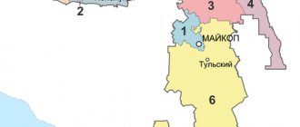
10 districts of the Republic of Adygea include cities, towns and villages. There are two capitals in the region: Maykop and Adygeisk. Moreover, Maykop is considered the main city of the republic.
There are also eight districts in Adygea:
- rural area of Maykop;
- Giaginsky;
- Koshekhablsky;
- Shovgenovsky;
- Takhtamukaisky;
- Teuchezhsky;
- Maikopsky;
- Krasnogvardeisky.
In the regions of the Republic of Adygea, the Russian population predominates. Only in Adygeisk, Teuchezhsky and Shovgenovsky districts are there more Circassians than other nationalities.
There are two official languages in the republic: Russian and Adyghe. Armenian, Ukrainian and Kurdish languages are also common. The region's population does not even reach half a million people. There are 63% Russians here, 25% Adygeis, 4% and 2% Armenians and Ukrainians each. The area of Adygea is one of the smallest in the country: only 7 thousand km2. In terms of area, the republic ranks 81st out of 85 regions of the country.
The climate in Adygea is quite warm. In winter, the temperature rarely drops below -2 °C; in summer, the average temperature here is +28 °C. Due to the warm climate, the republic is rich in natural resources. Natural gas, clay, gravel, sand, limestone and other minerals are mined. Almost half of the territory is occupied by broad-leaved forests.
St. Michael's Monastery of Athos
The monastery is located on the outskirts of the village of Pobeda and occupies a mountain plateau on the northern spurs of the Greater Caucasus Range. In clear and sunny weather, magnificent views of the Caucasus Mountains open from the territory of the monastery. Today this place is a major tourist center, whose doors are open to tourists and pilgrims.
On the territory of the monastery there are churches: Holy Trinity, Assumption, Archangel Michael and others.
One of the buildings deserves special attention - this is the mass grave of disabled people killed by the Nazis.
Sights of Guamka
There are many attractions in Guamka. Today this village is included in the list of the most visited places by tourists. According to traveler reviews, the places described below deserve special attention. The village is located in the Krasnodar region, almost on the border with Adygea.
Where to stay in Guamka – here
Guam Gorge
Perhaps this is the most beautiful place not only in the Krasnodar Territory and Adygea, but throughout Russia. The fascinating view of the crevice, created by nature itself, attracts a huge number of guests to the region. The length of the gorge is about three kilometers, and the height of the walls in some places reaches 500 meters. You can ride along the gorge along the narrow-gauge road on the Zine trolley, to cafe 1707 or further. Multi-colored stones washed with water add zest. Sometimes there are water cascades that amaze the imagination. Read more…
Narrow gauge railway in Guam Gorge
The construction of the narrow-gauge Absheron road in the Guam Gorge began in the early 20s of the last century. Previously, the road was the longest in the mountains of Russia. Today its length is about 2 kilometers. Today, three carriages are used to transport passengers; sometimes motorized railcars run, taking passengers further than the final stop of the train. This is an ideal option to enjoy the delights of the gorge without climbing mountains. Read more…
Waterfalls on the Matuzka River
These water cascades fascinate with their grandeur and unsurpassed beauty. The highest one falls from a height of 12 meters, along ledges. Even in winter it’s fabulously beautiful here, especially if you’re lucky, the waterfall won’t freeze. You will be able to watch an amazing picture of a crystal clear turquoise stream of life-giving moisture descending from a snow-capped mountain. But even if it freezes, it will still have a unique appearance. More details, map, GPS coordinates
Observation deck (shelf) “Eagle”
An amazing place with a stunning panorama of the surrounding area. You can get here by two paths, and at any time of the year. The climb is not difficult, suitable even for inexperienced tourists; some take children with them. In winter, however, some caution must be observed. It is located in the Guam Gorge area, so it can easily be considered one of the main attractions of the gorge. In general, there are several sites in these parts, but this one is special. More details, map, GPS coordinates
Dry beam and Yavorov waterfall
The beam and waterfall are located on the territory of the same Guam Gorge. The places here are not just beautiful, they are charming. But it is advisable to go to them in dry, windless weather. Not a very good choice for walking in winter. Although if you do get to them, you are guaranteed a lot of unique impressions. The waterfall is not the highest (50 meters), but one of the most beautiful. The falling streams along the cascade evoke mixed feelings. More details, map, GPS coordinates