| Coat of arms of Pokrovsk (Yakutia) | |
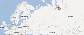
| A country | Russia |
| Subject of the federation | Yakutia |
| Ulus | Khangalassky |
| urban settlement | City of Pokrovsk |
| Vehicle code | 14 |
| OKATO code | 98 420 |
| Coordinates | Coordinates: 61°29′00″ N. w. 129°09′00″ E. d. / 61.483333° s. w. 129.15° E. d. (G) (O) (I)61°29′00″ n. w. 129°09′00″ E. d. / 61.483333° s. w. 129.15° E. d. (G) (O) (I) |
| Official language | Russian |
| Timezone | UTC+10 |
| Climate type | sharply continental |
| Center height | 90 m |
| Telephone code | +7 41144 |
| Postcode | 678000 |
| Based | 1682 |
| City with | 1997 |
| In the encyclopedia “My City” | Pokrovsk |
| Head of Administration | Nikolay Adosovich Vesvalo |
| Population | ▲ 10,223 people (2010) |
Pokrovsk (Yakut. Pokrovskaya) is a city, the administrative center of the Khangalassky ulus, in central Yakutia.
Population - 10.2 thousand people (2010).
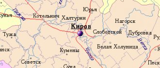
A city on the left bank of the Lena, 78 km southwest of Yakutsk.
Economy
Transport
Connected by an asphalt road with Yakutsk (route R-501). City public transport - bus. There are suburban and intercity bus services to Yakutsk. River pier. Ferry crossing across the river. Lenu “Mokhsogolloh—Kachikatsy.”
Industry
The city has a building materials plant, an asphalt bitumen plant, a plant for the production of basalt products, and a glass plant is under construction.
Forestry A fur farm engaged in breeding silver-black foxes and sable. Compound feed plant.
A new city in Yakutia was almost called a dissonant word
IA SakhaNews. In 1975, a new city under construction in Southern Yakutia was almost called a dissonant word. There are many versions of what Neryungri should actually be called.
A settlement named Nirungra (after the name of the river) was first mentioned in the documents of the Chita geological exploration expedition in 1952. In the summer of 1951, major discoveries of coal deposits took place in South Yakutia. Taking into account these discoveries, on March 4, 1952, the Council of Ministers of the USSR adopted a resolution “On preparation for the industrial development of the Aldan-Chulman group of iron ore and coal deposits of the YASSR.” This document bears the personal signature of J.V. Stalin .
In June 1952, the first tents appeared at the mouth of the Nirungra River at its confluence with the Chulman River. By 1955, the village of Nirungra was built up with the same type of log houses, which formed four streets - Chulmanskaya, Profsoyuznaya, Sportivnaya and Naberezhnaya.
On September 3, 1963, a column of nine bulldozers and a team of workers arrived in the village of Nirungra. They became the founders of a new site, which further increased the population of the village.
On February 24, 1972, a Decree of the Presidium of the Supreme Council of the YASSR was signed giving the settlement, which was first named “Neryungri” in official documents, the status of a workers’ village. Residents of the former village of Ugolny began to move here en masse.
On November 6, 1975, Decree of the Presidium of the Supreme Soviet of the RSFSR 1017 “On the transformation of the workers’ village of Neryungri into a city of republican subordination” was issued, which was signed by the Chairman of the Presidium of the Supreme Soviet of the RSFSR Mikhail Yasnov and Secretary Khrisanf Neshkov . According to the document, the territory that included Neryungri, Iengra, Chulman, founded in 1926, the rapidly growing railway stations Berkakit and Zolotinka, the village of Serebryany Bor, was separated from the Aldan region.
The second secretary of the Neryungri City Committee of the CPSU in 1975-1983, the chairman of the executive committee of the Neryungri City Council of People's Deputies in 1983-1989, Pyotr Fedorov, .
“We, the leaders of the new city, arrived in Neryungri immediately after our appointment, in early November 1975. A few days later I went to the village of Iengra, where I met the local residents. Among them was the village elder, a veteran of the Great Patriotic War, Semyon Mikhailovich Lekhanov from the ancient Evenki family “Puyagir”. Two years later, he became the first honorary citizen of the city among all Neryungrin residents.
Semyon Mikhailovich began working on the Tokarikan collective farm at the age of 17, and at the age of 21 he was elected chairman of the local Council of Deputies. At the age of 24 he went to the front. Having returned to his native village with the Victory, he became one of the organizers and leaders of the collective farm among the Evenks, the chairman of the “Friendship” collective farm.
At one time, the Lekhanovs and Kolesovs, who belong to the Buta and Puyagir clans, moved to Iengra from Gonam. Their ancestor is the old man Ulukitkan , who became a literary hero in the works of Grigory Fedoseev .
I asked Semyon Lekhanov: how is the word “Neryungri” translated from the Evenki language? He explained that "neru" or "niru" means grayling. The suffix "nda" or "ngr" means location. That is, “Neryungri” in translation is “the location of grayling.”
But Semyon Mikhailovich Lekhanov himself never called our city that. He said “Neromna” - that’s what he, an elderly Evenk, called the city that we know as Neryungri.
In December 1976, the Neryungri City Committee of the CPSU received a handwritten letter from a linguist from Leningrad. First Secretary Ivan Pyankov handed it to me. The scientist said that we had named the future city incorrectly, and if it means “grayling river,” then we should call it “Nerunda.”
We didn't like this name right away. I tell Ivan Ivanovich: this is not Neryungri, but it turns out to be some kind of “nonsense”. We did not give an answer to the scientist. But the word Neryungri stuck and eventually became generally accepted.”
, - said Pyotr Fedorov.
However, the firm position of the founding fathers of the new city did not completely eliminate the discrepancies in the name of the city. , the last Minister of the USSR Coal Industry, Mikhail Shchadov, called the city as it was recorded in documents by Chita geologists - “Nerungra”.
A little later, a legend was born that the city was originally called “Nyurengri”, but an absurd error in the documents swapped the vowels. They allegedly did not rewrite the maps, and as a result, the modern name stuck.
Pyotr Semyonovich Fedorov refutes this legend. There were no typos, he said. From the word “Nyurengri” comes only the popular nickname of the city - “Nyurka”, which is sometimes colloquially used by some local residents and not the most polite guests to call the capital of South Yakutia.
Oleg SOLODUKHIN.
Neryungri
Story
The year of foundation is considered to be 1682, in which the last uprising of the Khangalas Yakuts against the Cossacks took place. After the defeat of the rebels on October 1 (11), on Pokrov Day, the troops of the governor Ivan Priklonsky installed a large wooden cross, called Pokrovsky, on a high guard cape (Yakut. Khoruol tumua).
In 1703, part of the hermits of the Spassky Monastery from Yakutsk moved to a new place and founded a unique branch of the monastery, called the Intercession Hermitage. In 1724 the hermitage burned down. Several families of Russian peasants settled in its place.
The settlement then became a coachman's station on the Lena highway. In 1870, a second church was built in Pokrovsk, which gave it the status of a village.
In 1931, Pokrovsk became the administrative center of the West Kangalassky district, which was then renamed Ordzhonikidze, now Khangalassky. In 1941 it received the status of an urban-type settlement.
On September 26, 1997, it was given city status.
In 1916-1917 Sergo Ordzhonikidze served his exile here.
- The capital of Yakutia is the city of Yakutsk
- Sottintsy in Yakutia
- The fate of the prison
- Houses built in permafrost conditions
- Tuymaada
- Ice Beach
- Yakut exile
- Platon Oyunsky
- Namtsy village
- Maxim Ammosov
- Nizhny Bestyakh city
- Amur-Yakutsk railway
- Maya village
- Ensemble Katylak
- Toyon Tower
- Vasily Fedorov - Manchaars
- Ytyk-Kyuel village
- Suorun Omolloon
- City of Pokrovsk
- Sergo Ordzhonikidze
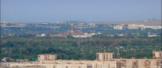
City of Pokrovsk.
Pokrovsk is located on the left bank of the Lena, 78 km southwest of Yakutsk.
In the old days, there was a guard post at this place, Tygyn Darkhan. From the high cape a wide panorama of the Lena River up and downstream opened up, which is why the cape was called Karaulny. The city is located among taiga forests; agriculture, mainly fur farming, is developed in its vicinity.
The year of foundation of the city is considered to be 1682, when the last uprising of the Khangalas Yakuts against the Cossacks took place. It was an armed rebellion against excessive tribute collections, but it was not destined to succeed. After the defeat, on Pokrov Day, October 11, the troops of the governor Ivan Priklonsky erected a large wooden cross on the cape, called Pokrovsky; A few years later, some of the hermits of the Spassky Monastery from Yakutsk moved to him.
In 1720, a church was built here, then there was a fire within the monastery walls, but people never left: several families of Russian peasants settled on the site of the temple. Over time, the settlement became a coachman's station on the Prilensky tract. The village grew, church after church was built, the importance of Pokrovsk gradually increased, but it was given the status of a city relatively recently - only in 1997.
The cultural center of the entire Khangapasssky ulus is the Khangalassky Ulus Local History Museum named after G.V. Ksenofontov. It opened in 1962 as the S. Ordzhonikidze House-Museum. Its founder was a teacher of the Pokrovsk secondary school, honored cultural worker S. D. Ivanov.
The wooden building in which the exhibition is located was built in 1912 as an outpatient clinic. From August 1916 to February 1917, exiled revolutionary Grigory Konstantinovich Ordzhonikidze (Sergo) lived and worked in this house. That is why in 1975 the building was recognized as a monument of republican significance and taken under state protection. A monument to the revolutionary was erected in front of the porch. By the way, during the years of Soviet power, the Khangalassky district was called Ordzhonikidze.
Perestroika played a serious role in the fate of the museum: in 1991 it became a branch of the Yakut State United Museum of History and Culture of the Peoples of the North named after. E. Yaroslavsky. The Pokrovsky department received its own specialization - the history of the Lena coachmen's stations. On February 19, 1993, the Khangalassky Museum of Local Lore was named after G.V. Ksenofontov, an ethnographer, a native of the Khangalassky ulus.
In 2007, for the 325th anniversary of Pokrovsk, by the decision of the city residents and with the blessing of Bishop Zosima of Yakutsk and Lensky, the Church of the Intercession of the Mother of God was rebuilt in the city. To commemorate the start of construction, Vladyka erected a cross at this place, and later, in a little over a year, the church building was built. A church with the same name operated in Pokrovsk before the revolution, but during the years of Soviet power it was closed and destroyed. The modern church is airy, three-domed, soft turquoise in color, with an elegant white porch. The church stands on the high bank of the Lena and looks very beautiful from river boats passing by. A couple of years ago there was a landfill here, but the townspeople cleared this area for the temple.
On the outskirts of the city of Pokrovsk, in the Zavodsky district, the first Basalt plant in the republic operates - an innovative enterprise producing insulating materials for the construction industry of Yakutia and basalt reinforcement.
In the suburbs of Pokrovsk, in the village of Kerdem, there is the Samartai Museum Complex. It is located on the territory of the estate of the St. Nicholas Church. The museum's collection includes 340 exhibits that tell the history of the Lena village. The director of the museum, Robert Konstantinovich Zakharov, is an old resident of these places and an enthusiast.
In “Samartai” you can see a peasant grain dryer, a hexagonal house - babaarynu, built in the 18th century, the barn of Bai Kirill, and ancient household items.
The old Kachikat-Nicholas church, which houses the museum, was erected in 1890 in honor of St. Nicholas the Pleasant. One of the goals of director Zakharov is the restoration and maintenance of this temple.
Climate
The climate of Pokrovsk, like Yakutsk, is distinguished by a very high degree of continentality. Summers are warm, often hot, but short, and winters are very long and harsh. In winter, temperatures can drop to 60 °C; in summer, temperatures above +35 °C are sometimes possible.
| Climate of Pokrovsk | |||||||||||||
| Index | Jan | Feb | Mar | Apr | May | Jun | Jul | Aug | Sep | Oct | But I | Dec | Year |
| Average temperature, °C | 39,7 | 33,7 | 21,1 | 5,4 | 6,7 | 15,2 | 18,6 | 14,4 | 5,7 | 8,1 | 27,2 | 38,1 | 9,3 |
Add a comment
Comment
Send
Links[edit]
Notes[edit]
- ^ abcdefghi Register of administrative-territorial units of the Republic of Sakha
- ^ abc Federal State Statistics Service (2011). “All-Russian Population Census 2010. Volume 1" [All-Russian Population Census 2010, vol. 1]. All-Russian Population Census 2010 [All-Russian Population Census 2010]
. Federal State Statistics Service. - "26. The size of the permanent population of the Russian Federation by municipalities as of January 1, 2022". Federal State Statistics Service. Retrieved January 23, 2022.
- ^ abcd Law No. 173-Z No. 353-III
- Law No. 172-Z No. 351-III
- "On the Calculation of Time". Official Internet portal of legal information
. June 3, 2011. Retrieved January 19, 2022. - Post office. Information and computing center of OASU RPO. ( Post office
).
Search for postal service objects ( postal Search for objects
) (in Russian) - ↑
Federal State Statistics Service of Russia (May 21, 2004).
“The population of Russia, the constituent entities of the Russian Federation as part of federal districts, urban settlements, settlements, settlements of 3 thousand or more people” [Population of Russia, its federal districts, federal districts, districts, urban settlements, rural settlements - administrative centers and rural settlements with a population of more than 3,000 people] (XLS). All-Russian Population Census 2002
. - “All-Union Population Census of 1989. The current population of union and autonomous republics, autonomous regions and districts, territories, effects, urban settlements and rural district centers” [All-Union Population Census of 1989: current population of union and autonomous republics, Autonomous regions and districts, territories, regions, districts, urban settlements and villages performing the functions of district administrative centers. All-Union Population Census of 1989 [All-Union Population Census of 1989]
.
Institute of Demography of the National Research University: Higher School of Economics [Institute of Demography of the National Research University: Higher School of Economics]. 1989 - via Demoscope Weekly
. - “All-Union Population Census of 1979. National composition of the population by regions of Russia” [All-Union Population Census of 1979. Ethnic composition of the population by regions of Russia] (XLS). All-Union Population Census of 1979 [All-Union Population Census of 1979]
.
1979 - via Demoscope Weekly
(website of the Institute of Demography of the State University - Higher School of Economics.