Archive number No. 14 (1016) dated April 1, 2014 — News
NATIVE EDGE
This year our region will celebrate its 80th anniversary. On the eve of the anniversary, we decided to remember how the Kursk borders changed at different times.
Outpost on the border of Kievan Rus
Kursk was first mentioned in the Life of Theodosius of Pechersk around 1032. This year is officially considered the founding date of the city, although it is obvious that it existed before. Since the end of the 11th century, Kursk became one of the most powerful outposts on the border of Kievan Rus. In 1185, Prince Vsevolod of Kursk sent a squad against the Polovtsians. The high combat training and courage of our ancestors is narrated in the famous “Tale of Igor’s Campaign”: “And my Kuryans are experienced warriors, trained under pipes, groomed under helmets, fed from the end of a spear, their paths are known, their ravines are known to them, their bows are stretched, quivers open, sabers sharpened, they themselves gallop like gray wolves across the field, seeking glory for the prince and honor for themselves.”
The city was part of either Chernigov or Smolensk, Pereyaslavl and Suzdal principalities. Having become the center of an appanage principality, Kursk steadfastly endured both the internecine clashes of the Russian princes and the Mongol invasion of Batu Khan. From 1360 until the end of the 15th century, Kursk was part of the Grand Duchy of Lithuania, and in the 16th–17th centuries it was considered an important defensive point of the Moscow State, which it became part of in 1508. As part of the centralized Russian state, the Principality of Kursk still remained the southern border region of Rus'.
There are known mentions of Kursk in the “Book of the Big Drawing” (1517), in the decree of Ivan IV the Terrible of 1582, when the sovereign ordered the exile of “kromeshniks, rebels, rebels” “to the outlying cities of Sevsk and Kursk.”
The 16th century was a turning point in the history of Kursk. In 1597, a new fortress was erected in the city. Here, by order of the tsar, a mass of so-called “transfers” arrived - people forcibly transferred for military service and other matters of national importance. Kursk gave shelter to peasants and artisans, the homeless and serfs who flocked to the south, fleeing the tyranny of officials. Many were driven by the famine that gripped Central Rus' in 1601 and 1603. After the construction of a fortress on a river cliff above the Kur and Tuskary, the city became the military-administrative and economic center of a vast territory in the south of the Russian state that was gaining strength.
Between whom was the Kursk province divided?
In 1708, Kursk was assigned to the Kyiv province. In 1719, it was divided into four provinces, the territory of the current Kursk region was divided between two - Belgorod and Sevsk. In 1727, the Belgorod governorate was created, which included the Belgorod, Sevsk and Oryol provinces. In 1749 it was transformed into the Belgorod province.
In 1779, the Kursk governorate appeared, consisting of 15 counties (Belgorod, Bogatensky, Dmitrievsky, Korochansky, Kursk, Lgovsky, Novooskolsky, Oboyansky, Putivlsky, Rylsky, Stary Oskolsky, Sudzhansky, Timsky, Fatezhsky and Shchigrovsky). In 1797 it was transformed into the Kursk province, which existed until 1928.
In 1928, the Central Black Earth Region was created on the territory of the Voronezh, Kursk, Oryol and Tambov provinces. Most of the Kursk province was included in the Kursk, Belgorod and Lgov districts, and its east - in the Voronezh and Ostrogozh districts. In 1929, the Starooskolsky district was formed from 13 districts, separated from the Voronezh (8 districts), Ostrogozhsky (three districts), Kursk and Belgorod (one district each) districts. In 1930, the districts were liquidated, and the districts began to report directly to the regional center.
Part of the land went to neighbors
The Kursk region was created by a resolution of the Presidium of the All-Russian Central Executive Committee of June 13, 1934. It included 60 districts, including 21 from the former Oryol and Voronezh provinces. At the time of its formation, about 5 million people lived in the region, of which more than 4 million lived in rural areas.
In 1935, as a result of a revision of the intraregional administrative-territorial division, 93 districts were formed. Subsequently, the territory of the region decreased: according to the resolution of the Central Executive Committee of the USSR dated September 27, 1937, 25 districts were transferred to the formed Oryol region. In July 1944, four more districts joined it. In January 1954, in connection with the formation of the Belgorod and Lipetsk regions, the following were transferred from the Kursk region: to the first - 23 districts, to the second - three districts. Since 1954, the boundaries of the region have not changed.
* * *
Help "DDD"
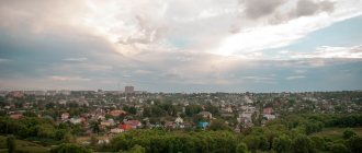
Now the Kursk region is part of the Central Federal District of the Russian Federation. Its area is about 30 thousand square kilometers. The population today is more than 1 million 119 thousand people. The northernmost point of the region is located in the Zheleznogorsk district, the southern - in Belovsky, the western - in Rylsky, and the eastern - in Kastorensky district.
The length of the region’s territory from north to south is 171 kilometers, from east to west – 305 kilometers. The Kursk region borders in the northwest with Bryansk, in the north with Oryol, in the northeast with Lipetsk, in the east with Voronezh, and in the south with Belgorod regions. The length of the borders is 1250 km.
The Kursk region is again a border region. The external borders with the Sumy region of Ukraine in the southwest and west are 296 kilometers and have the status of the state border of Russia.
Established symbols of the Kursk region
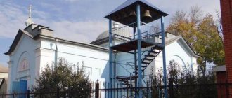
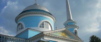
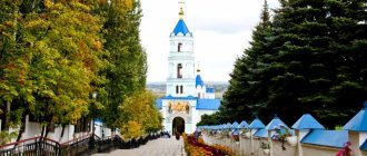
Root hermitage, Battle of Kursk (Kursk Bulge), Kursk nightingale, Maryino - the estate of the Baryatinsky princes in the Rylsky region, nightingale region, Streletskaya steppe, black soil, Kursk magnetic anomaly (KMA), Kursk Antonovka, Kursk Root Icon of the Mother of God “The Sign”, godmother move (in Kursk province).
More than 96% of Kursk residents are Russians
There is no “nationality” column in Russian passports today. Therefore, it is possible to obtain information about the ethnic composition of the population only during the All-Russian Census. Moreover, in accordance with the Constitution of the Russian Federation, everyone has the right to determine and indicate their nationality. A person may not answer this question at all.
During the last census, in 2010, only less than 5% of the region's residents did not indicate their nationality. Almost 96.5% of respondents, or 1 million 37 thousand Kursk residents, identified themselves as Russians. By the way, in the Russian Federation as a whole, 80% were Russian.
Ukrainians are in second place in the Kursk region. True, their number since the 2002 census has decreased from 1.7% to 1.27%. In 2010, there were 13.5 thousand of them. But the share of Armenians has increased slightly, there are 6 thousand of them in the region.
In total, according to Kurskstat, more than 130 nationalities live in our region.
Ivan PROKHOROV
Share link:
Subscribe to “For Each Other”:
Yandex News Yandex Zen Google News YouTube Video
author: O. ALEXEEVA
Did you know that the Kursk Magnetic Anomaly field is the largest in the world? Where is the highest point in the region? There are a great many “best” places in the Nightingale region. But we remember them from time to time, and sometimes we don’t even know about their existence. We will tell you about some local records.
Seven meter waterfall
The largest river in our region is the Seim (length - 748 km), 504 of them are located on the territory of the Nightingale region. Just think, the news will make the skeptics smile. But did you know that the bed of the current river was formed about 300 million years ago? Since then, advancing glaciers and other cataclysms have repeatedly changed the flow pattern, until (about 600 thousand years ago) it finally formed in the form of 902 rivers and streams, most of which still carry their waters along the Nightingale region. Their total length is almost eight thousand kilometers.
There are about a thousand lakes, ponds and reservoirs in the Seim basin. The largest lakes: Lezvino (7.3 km long), Malino (4.5 km), Makovye (4.1 km), Fitizh (3.4 km).
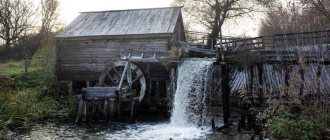
There is also a waterfall in the Kursk region, although it is artificial. It is located 62 kilometers from Kursk in the village of Matveevka, Zolotukhinsky district. A huge, endless pond, at one end of which water falls in two powerful streams from a seven-meter height and flows into a stream overgrown with dense bushes. If you stand next to a waterfall, the noise of the water drowns out your speech, and in order for your interlocutor to hear you, you need to shout. It was built almost thirty years ago to drain excess water from the pond.
The oldest street
The highest point of the region - 274 meters - is located on the border of Fatezhsky and Ponyrovsky districts within the so-called Fatezh-Lgovskaya ridge. The Teplovsky Heights (255 meters) in the Ponyrovsky district are slightly inferior to it. In July 1943, they became the scene of fierce battles with the Nazis. Konstantin Simonov, Ilya Erenburg, and Evgeny Dolmatovsky came here for their articles and reports. By the way, in clear weather Kursk is visible from the Teplovsky Heights.
The tallest creation of human hands in the Nightingale region is the 180-meter “needle” of the television tower on 50 Let Oktyabrya Street in the regional center. Above it there is only the sky. Moreover, the TV tower is installed at the highest point of Kursk - 252 meters above sea level. Antenna specialists “reach” the top of the stairs in 40 minutes - they have trained.
The longest street is also located in the regional center - 50 Let Oktyabrya. It stretches for 5 kilometers 200 meters. Until 1967, the street was called Vygonnaya, because cows were driven out to pasture along it. Although many still believe that the record belongs to Karl Marx Street. But relatively recently, a “piece” was cut off from it in favor of Pobeda Avenue (the area where the Northern Microdistrict is being built and the Triumphal Arch was erected). So now the street named after the communist theorist has been reduced to three kilometers, three hundred meters. And the longest avenue is Leninsky Komsomol (5.5 km). By the way, in pre-revolutionary Kursk, Kherson (now Dzerzhinsky) was considered the longest - two miles (a little more than two kilometers).
The oldest Scythian well
It was in the Kursk region that the Scythians left one of the most interesting monuments steeped in myths and legends. On the territory of the ancient settlement in Lipino (Oktyabrsky district), archaeologists discovered the oldest well in Russia. Presumably, it was dug by the Scythians in the eighth century and reached a depth of 11-14 meters; excavations reached a depth of only 3.5 meters. Theoretically, there could not be good water in it. But the analysis showed the opposite: all impurities accepted as acceptable in drinking water were reduced by 10 times.
The “long-lived” bridge can be called the one built over the Tuskar River not far from the circus building in Kursk. It leads from Sonina Street to Streletskaya Embankment Street. The bridge was built in 1878 - simultaneously with the railway line that ran in that area (the city railway station was located on the site of the circus until 1969). Since then, the bridge has been repaired, but the metal structure itself and the openwork forms of the decorative part of the bridge remain the same.
The material was published in the newspaper “United Russia. Kursk" dated January 12, 2011
Your comment:
Up ▲ — Reader reviews (3) — Write a review ▼ — Print version
| e-mail, city: St. Petersburg | |
The article contains a number of inaccuracies. Kursk was never part of the Smolensk and Suzdal principalities. In the XIV-XVI centuries. Kursk did not exist, so it could not be considered any “important defensive point of the Moscow state” at that time. The construction of the Kursk fortress dates back to 1596, and not to 1597. In 1727, the Belgorod province was formed, not the governorship; there was no “transformation” of the Belgorod province in 1749. Governorship and province are synonymous; there was no “transformation” of the Kursk “government” into a “province” in 1797 (this is a common misconception, widely represented in reference literature). As an important addition, we should point out the fact of the transfer from the Kursk province in 1925 of the city of Putivl with the adjacent district to the Ukrainian SSR.
| Andrey | 5 April 2014, 13:59:47 |
An excellent article, but I wanted to add a little)) Among the “migrants” in the period of the late 16th and early 17th centuries, there were a large number of so-called “Byar children”, this is a military class class, later they began to be called odnodvortsy. They were allocated land on which they farmed, and the head of the family was in the military service of the state. Representatives of the same palace occupied officer positions. The settlements they founded often bore the surnames of the founders in their names. This was the case with my ancestors, who founded the settlement, which is now called Apalkovo, and in the 1645 census books it was written as Opalkova. Later, other members of the same palace, for example the Lobyntsevs, began to gain strength in this village. These same-palaces became the founders of many families that are considered Kursk. As for the national composition, in the Kursk province of 18-19 many called themselves Sevryuks (most likely these are descendants of northerners, Severians). There were also nationalities who called themselves Sayans, Goryuns, after 1917 they became Russians. And also in the Kursk region there is a huge number of Ukrainians who have forgotten their roots.
| passer-by | 9 April 2014, 09:52:05 |
| city: Kursk | |
To the established symbols of the Kursk region we must add the Kursk tram - the 2nd in Tsarist Russia, opened in 1898 (1st - in Nizhny Novgorod).
Crop production in the Kursk region
Growing grains
In the general structure of the agricultural production system, the cultivation of various grain crops is the main specialization. The total share of grain crops in the total gross percentage of the sector's output fluctuates from year to year from 55.3 to 58.2%. Over the past 10 years, the leading shares in the total amount of industrial crop production grown were occupied by the following crops: triticale (wheat-rye hybrid), both winter and spring - in this area, the Kursk region has been among the top three among all regions of the Russian Federation since 2015, and also: corn intended for sowing, spring or winter barley, wheat, rye, millet and oats.
In terms of growing legume crops, the Kursk region ranks 13th among all other regions of the country. In terms of volumes of growing high-quality fodder and food beans (7th place) and green peas (16th place).
In the cultivation of soybeans and beets - 5th place in the Russian Federation, in the cultivation of mustard and fodder sunflower - in 12th place, camelina seeds and oilseed rape - in 15th position, and in the number of potatoes grown (taking into account root crops for industrial use) - in 44th place, taking into account private farms.
According to experts, in the coming decades, crop production will remain the main vector of work and development of the Kursk region. The plans of the regional government include a long-term project to increase the volume of grain crops grown up to 2024 to 6 million tons per year. To this end, comprehensive measures are being taken to increase harvest productivity to 55-60 centners per hectare, and the construction of regional centers for the storage and primary processing of grains, oilseeds and legumes has already begun.
Relief. Climate
The climate of the Kursk region is considered to be temperate continental due to the fact that winter temperatures range from -7 and a half degrees Celsius in the west to almost -10 degrees in the north, and in summer about 20 degrees in all areas. Of course, in the north the temperature is several degrees lower. Kursk residents receive up to 600 mm of precipitation per year, and this amount drops to 480 mm in the east and south - the warmest regions of the Kursk region. In winter there is snow, in summer there are heavy downpours. In spring, dry easterly and southeasterly winds often blow. The frost-free period in the region lasts about six months, i.e. approximately 150 days.
The zone of the Kursk region is forest-steppe. Thus, broad-leaved forests grow everywhere in river valleys and ravines. These are the large rivers of the region (Seima, Psela, Svapy). The forests consist of linden, maple, oak, ash, pine and some other species. Planted pine forests are found on the sandy terraces of the same large rivers. The soil in the region is varied. These are different types of chernozems. Natural vegetation has been preserved only in protected areas (Streletskaya and Kozatskaya steppes of the Central Black Earth Nature Reserve named after V.V. Alekhine, which you can read about below). Animals of the Kursk region are:
Martens, hares, moose, roe deer, foxes, gophers, beavers, squirrels, muskrats and others.
Flora and fauna
The natural zone of the Kursk region is quite diverse. There are various forests in the region. Bor is not typical for this area. If you are walking in a forest, then most likely it is the work of man. On the territory of the Kursk region there are birch and aspen forests, oak forests and hazel trees. Kursk residents love to collect mushrooms: boletus, boletus, boletus, russula and others.
Reeds, alder, reeds, willow, egg capsules, water lilies and various algae grow in swamps and ponds.
This climate and nature are good for different animals. The groves and forests are home to elk, wild boars and roe deer. Badgers also love the Kursk forests. The wolves were almost exterminated. But foxes, on the contrary, feel at ease in these parts. They hunt for game even in swamps. They love the hedgehogs and squirrels that live here. There are a huge number of lizards and even snakes on the ground. It’s not uncommon to see a viper or snake in the forest.
The world of birds in the forests of the Kursk region is diverse. Warblers, finches, and woodpeckers live here. There are also blackbirds and cuckoos, turtle doves, partridges and corncrakes, as well as the sung Kursk nightingales.