Geography
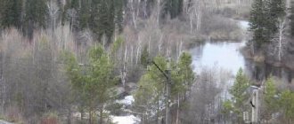
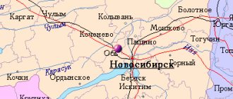
Kirensk is located in a floodplain bend of the Lena River at the confluence of the Kirenga River, on both banks of these rivers and on an island at their confluence, 650 km north-northeast of Irkutsk (in a straight line). The island is connected to the mainland by a dam.
The height of Kirensk above sea level is 255 m.
The left bank part of the Lena is more elevated. From the northeast, Kirensk is covered by Mount Sokolinaya, from which a picturesque view of the island city opens.
Topographic map of square O-49-B (North Baikal Highlands, Kirensk)
Transport accessibility
The nearest cities are Ust-Kut (170 km to the southwest), Severobaikalsk (250 km to the southeast).
The Lena River is the main transport route of Kirensk and the entire Kirensky district. In this section it has guaranteed depths and is navigable from the second half of May to the end of October (five months a year).
Kirensk Airport is located within the city limits, 3 km west of the city center. It can accommodate light (An-2) and medium (An-24 and -26, Yak-40) aircraft and helicopters. Provides regular flights to the regional center and a number of other settlements in the region.
During the Great Patriotic War, the airport was a key point on the air route to Yakutia and an intermediate point for ferrying aircraft from the United States (from Alaska) to the front. In those years there was no stable navigation. Special skill was required from pilots and navigators. The planes were on the road for six hours, and in winter they flew even in snowfalls, when the wings and stabilizer were covered with ice. The most difficult section of the route was on the Kirensk - Krasnoyarsk section.
The airport retains its significance as an important northern air hub today due to its convenient geographical location in the center of the northern regions of the Irkutsk region. Through the airport, aviation services are provided to the population in the northern regions of the region and aviation work is carried out to service fields in the northern part of the Irkutsk region and in Yakutia. As of 2020, flights are operated:
- regular: IK 83/84 (Irkutsk–Kirensk–Irkutsk);
- irregular: Kirensk–Nepa–Preobrazhenka–Erema–Erbogachen–Khamakar–Nakano (3 times a month); Kirensk–Tokma–Bur–Ika (3 times a month); Kirensk–Mironovo–Korshunovo–Vizirny (2-3 times a month).
Kirensk is connected by road with Ust-Kut (338 km), as well as with a number of nearby villages. But due to the poor development of the road network, motor transport does not play a significant role in the economy of this territory (unlike water transport). Only in winter does the share of freight and passenger transportation by road increase noticeably. Winter roads operate continuously from November to April.
In general, the city of Kirensk belongs to the territories of the Irkutsk region, where mass delivery of goods is carried out in a limited time frame - in the summer by water transport.
Distance from Kirenskaya to other cities by road, km
| City | Distance |
| Ust-Kut | 338 |
| Bratsk | 707 |
| Winter | 856 |
| Cheremkhovo | 863 |
| Irkutsk | 920 |
| Tulun | 932 |
| Shelekhov | 938 |
| Angarsk | 964 |
| Ust-Ilimsk | 967 |
| Bodaibo | 1040 |
| Nizhneudinsk | 1055 |
| Baykalsk | 1071 |
| Taishet | 1212 |
Kirensk
Kirensk is the oldest existing city in the Irkutsk region. It was founded by a Cossack detachment led by foreman Vasily Bugr in 1630 (31 years earlier than Irkutsk) on the Lena River as Nikolsky Pogost.
In 1665, a fort - Ust-Kirensk - was founded on the site of the graveyard. It got its name from the Kirenga River, which flows into the Lena at this very point. According to the most common versions, this name came from the Evenki language: from kirenӈa meaning “eagle’s nest”.
A fair and customs office were organized at the prison. And the first posad houses appeared nearby. At the beginning of the 18th century, Kirensk was already a fairly populated settlement, where there was the Spasskaya Church and a hut, there was a guest house, a customs house, barns, shops, about 40 residential buildings and a chapel.
The settlement received city status and the name Kirensk in 1775. Eight years later, Kirensk became a district town, and in 1822 - a district town of the Irkutsk province. At that time there were 140 houses, 5 churches and 10 shops.
The strategic location of Kirensk, which became a springboard for the Russian advance to the east. In those years, it was Kirensk that was the last stronghold on the way to Yakutia, Kamchatka and Chukotka, as well as to Russian America. It was here that the famous Cossack, pioneer and discoverer of new lands in eastern Russia, Erofei Khabarov, lived from the moment the settlement was founded until the end of his years.
Kirensk became the base for the preparation of the Northern Expedition of the Laptev brothers (the sea in the Arctic Ocean was named after them). Kirensk welcomed famous researchers - Chersky, Chekanovsky, Obruchev, Shishkov. After inspecting Russian possessions in North America and establishing political and trade relations with Japan, the Governor-General of Eastern Siberia Nikolai Muravyov-Amursky stayed in the city, and the writer Ivan Goncharov was also here. Nikolai Chernyshevsky was imprisoned in the Kirensky transit prison.
During Soviet times, Alexey Nikolaevich Kosygin, who later became Chairman of the Council of Ministers of the USSR, lived and worked in Kirensk. The famous surgeon Fyodor Grigorievich Uglov, the oldest practicing surgeon in the world, was born in Kirensk. He performed unique, complex operations, after which he was applauded by many medical luminaries of the world. The outstanding surgeon died in 2008, when he was 103 years old.
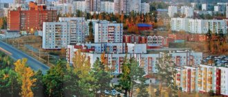
By the mid-70s of the last century, the population of Kirensk had grown to 16.5 thousand people. The largest enterprise was the Kirensky river port. In recent years, the population has been decreasing due to the outflow of young people to the “mainland”. Now the city has 12 thousand inhabitants.
Currently, the island part of the city retains the pre-revolutionary merchant appearance of Kirensk; it looks like a large open-air museum. Many of the houses here are landmarks and are associated with interesting events and personalities. Today, Kirensk clearly stands out from a number of Siberian cities with its architectural originality, the uniqueness of the harmonious combination of city blocks with the majestic landscapes of the Lena River and some special independence of appearance.
Population
Population dynamics
| 1856 | 1897 | 1926 | 1931 | 1959 | 1970 | 1979 | 1989 |
| 900 | 2300 | 4700 | 7900 | 14 412 | 14 453 | 16 154 | 16 137 |
| 1992 | 1996 | 1998 | 2001 | 2002 | 2003 | 2005 | 2006 |
| 16 500 | 16 200 | 15 600 | 15 100 | 13 712 | 13 700 | 13 100 | 12 900 |
| 2007 | 2009 | 2010 | 2011 | 2012 | 2013 | 2014 | 2015 |
| 12 800 | 12 433 | 12 640 | 12 599 | 12 359 | 12 066 | 11 802 | 11 568 |
| 2016 | 2017 | 2018 | 2019 | 2020 | |||
| 11 436 | 11 310 | 11 139 | 11 046 | 11 048 |
Climate
Kirensk has a sharply continental climate.
| Climate of Kirensk | |||||||||||||
| Index | Jan. | Feb. | March | Apr. | May | June | July | Aug. | Sep. | Oct. | Nov. | Dec. | Year |
| Absolute maximum | 1,4 | 7,0 | 16,1 | 24,4 | 32,2 | 36,8 | 36,6 | 36,5 | 29,3 | 24,0 | 8,9 | 4,1 | 36,8 |
| Average maximum, °C | −21 | −14,8 | −3,6 | 5,5 | 15,4 | 22,8 | 25,2 | 22,0 | 12,9 | 2,6 | −10,5 | −19,4 | 3,1 |
| Average temperature, °C | −26,6 | −22,3 | −12,7 | −1,4 | 7,8 | 15,3 | 18,3 | 15,1 | 6,7 | −2,1 | −15,5 | −24,5 | −3,5 |
| Average minimum, °C | −32,2 | −29,1 | −21 | −8 | 0,9 | 7,8 | 12,2 | 9,5 | 2,3 | −6 | −20,5 | −29,7 | −9,4 |
| Absolute minimum, °C | −57,8 | −56,2 | −47,7 | −36,8 | −13 | −3,8 | 0,4 | −5,3 | −10,8 | −37,6 | −49,6 | −57 | −57,8 |
| Precipitation rate | 19 | 14 | 11 | 14 | 32 | 52 | 67 | 60 | 42 | 32 | 28 | 26 | 397 |
| Source: [pogoda.ru.net/climate/30230.htm Weather and climate] | |||||||||||||
Economy
Water transport remains the city-forming basis of Kirensk. This industry is represented by OJSC Kirenskaya Fleet Electronic Warfare and a ship repair plant.
The second most important branch of Kirensk's specialization is logging. The region has significant timber resources (the estimated cutting area is one of the largest in the region - 5.3 million m3).
Other industries include the food industry, trade, and consumer services. These types of activities are mainly carried out by private entrepreneurs.
Read on Irkipedia:
- Kirensky electronic warfare of the fleet
- Kirensky district of waterways of the Federal State Institution "Lena State Basin Administration of Waterways and Shipping"
- Economic and cultural development of Kirensk in the second half of the 19th – early 20th centuries.
- Merchants, traders and entrepreneurs of the city of Kirensk
Notes
- ↑ 123
www.gks.ru/free_doc/doc_2016/bul_dr/mun_obr2016.rar Population of the Russian Federation by municipalities as of January 1, 2016 - [www.nlr.ru/e-res/law_r/search.php?regim=4&page=512&part=89 The highest approved report of the Senate, with the attachment of coats of arms of the cities of the Irkutsk governorship. // Complete collection of laws of the Russian Empire. - 1777. - Volume 20. - Law No. 14598.]
- [www.nlr.ru/e-res/law_r/search.php?regim=4&page=28&part=262 Drawing of the coat of arms of Ust-Kirensk of the Irkutsk governorship].// Complete collection of laws of the Russian Empire. - 1777. - Volume 20. - Law No. 14598. Book of drawings and drawings.
- ↑ 123456789101112
[www.MojGorod.ru/irkutsk_obl/kirensk/index.html People's encyclopedia “My City”. Kirensk]. Retrieved November 12, 2013. [www.webcitation.org/6L4UAkGEM Archived from the original on November 12, 2013]. - [demoscope.ru/weekly/ssp/rus59_reg2.php All-Union Population Census of 1959. The size of the urban population of the RSFSR, its territorial units, urban settlements and urban areas by gender] (Russian). Demoscope Weekly. Retrieved September 25, 2013. [www.webcitation.org/6GDOghWC9 Archived from the original on April 28, 2013].
- [demoscope.ru/weekly/ssp/rus70_reg2.php All-Union Population Census of 1970 The size of the urban population of the RSFSR, its territorial units, urban settlements and urban areas by gender.] (Russian). Demoscope Weekly. Retrieved September 25, 2013. [www.webcitation.org/6GDOiMstp Archived from the original on April 28, 2013].
- [demoscope.ru/weekly/ssp/rus79_reg2.php All-Union Population Census of 1979 The size of the urban population of the RSFSR, its territorial units, urban settlements and urban areas by gender.] (Russian). Demoscope Weekly. Retrieved September 25, 2013. [www.webcitation.org/6GDOjhZ5L Archived from the original on April 28, 2013].
- [demoscope.ru/weekly/ssp/rus89_reg2.php All-Union Population Census of 1989. Urban population]. [www.webcitation.org/617x0o0Pa Archived from the original on August 22, 2011].
- [www.perepis2002.ru/ct/doc/1_TOM_01_04.xls All-Russian Population Census 2002. Volume. 1, table 4. Population of Russia, federal districts, constituent entities of the Russian Federation, districts, urban settlements, rural settlements - regional centers and rural settlements with a population of 3 thousand or more]. [www.webcitation.org/65AdCU0q3 Archived from the original on February 3, 2012].
- [www.gks.ru/bgd/regl/B09_109/IssWWW.exe/Stg/d01/tabl-21-09.xls Number of permanent population of the Russian Federation by cities, urban-type settlements and districts as of January 1, 2009]. Retrieved January 2, 2014. [www.webcitation.org/6MJmu0z1u Archived from the original on January 2, 2014].
- [195.46.100.221/vpn2010/DocLib/totals-vpn2010-2.pdf Results of the 2010 All-Russian Population Census for the Irkutsk Region]. Retrieved September 23, 2013. [www.webcitation.org/6JqAskf9l Archived from the original on September 23, 2013].
- ↑ 12
[www.irkobl.ru/sites/economy/Anticorrup_ekspertiza/statistika.doc Population by municipalities as of January 1, 2012: stat. Bulletin / Irkutskstat. – Irkutsk, 2012. – 81 p.]. Retrieved September 24, 2016. [web.archive.org/web/20160306103555/irkobl.ru/sites/economy/anticorrup_ekspertiza/statistika.doc Archived from the original on September 24, 2016]. - [www.gks.ru/free_doc/doc_2013/bul_dr/mun_obr2013.rar Population of the Russian Federation by municipalities as of January 1, 2013. - M.: Federal State Statistics Service Rosstat, 2013. - 528 p. (Table 33. Population of urban districts, municipal districts, urban and rural settlements, urban settlements, rural settlements)]. Retrieved November 16, 2013. [www.webcitation.org/6LAdCWSxH Archived from the original on November 16, 2013].
- [www.gks.ru/free_doc/doc_2014/bul_dr/mun_obr2014.rar Table 33. Population of the Russian Federation by municipalities as of January 1, 2014]. Retrieved August 2, 2014. [www.webcitation.org/6RWqP50QK Archived from the original on August 2, 2014].
- [www.gks.ru/free_doc/doc_2015/bul_dr/mun_obr2015.rar Population of the Russian Federation by municipalities as of January 1, 2015]. Retrieved August 6, 2015. [www.webcitation.org/6aaNzOlFO Archived from the original on August 6, 2015].
- taking into account the cities of Crimea
- [www.gks.ru/free_doc/doc_2016/bul_dr/mun_obr2016.rar Population of the Russian Federation by municipalities as of January 1, 2016. Table “31. Population of cities and towns by federal districts and constituent entities of the Russian Federation as of January 1, 2016.” RAR archive (1.0 MB)]
- lenaturflot.ru/en/peleduy-ust-kut-peleduy-raspisanie/ Schedule of high-speed passenger ships on the Peleduy – Kirensk line
Natives and residents
- Valeryan Mikhailovich Golitsyn - Decembrist, participant in the Russian-Turkish War of 1828-1829, the Caucasian War of 1817-1864.
- Maxim Lukich Galat - revolutionary.
- Fedor Grigorievich Uglov is a Russian surgeon, academician of the Russian Academy of Medical Sciences.
- Alexey Nikolaevich Kosygin is a Soviet statesman and party leader, head of the USSR Government.
- Afanasy Nikitich Antipin - WWII participant, writer, Honored Teacher of the RSFSR, Director of the Institute for Advanced Training of Teachers of the Irkutsk Region.
- Leonid Nikolaevich Kulagin is a Soviet and Russian actor, film director, screenwriter, People's Artist of the RSFSR.
- Evgeniy Vasilyevich Talalaev - Doctor of Biological Sciences, professor, one of the country's leading microbiologists, head of the Department of Plant Physiology and Microbiology at Irkutsk State University.