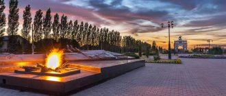
Kamensk-Uralsky
(Sverdlovsk region)
OKATO code:
65436
Founded:
1682
Urban settlement since:
1926
City since:
1935 City of regional subordination
Center:
Kamensky district
Urban areas, population as of 01/1/2021
| Krasnogorsky | Sinarsky |
| The city was formerly called: | ||
| Kamensk, Kamensky Plant | 1940 | |
| Telephone code (reference phone) | |
| 3439****** | — |
Deviation from Moscow time, hours:
2
Geographic latitude:
56°25′
Geographic longitude:
61°55′
Altitude above sea level, meters:
160 Sunrise and sunset times of the Sun and Moon in the city of Kamensk-Uralsky
ROAD
— Another largest completed infrastructure project is the bypass road. Without the Southern Bypass, the city would already be choking in the flow of cars and suffocating from exhaust fumes.
— This is actually a large-scale and life-saving object for Kamensk. Length - 46.5 km, 2 interchanges, 3 overpasses - across the railway and sludge dumps. 2 bridges across the Iset: one, 206 m long, in the Sverdlovsk region, the other, 212 m long, in the Kurgan region. Two lanes. The type of road pavement is permanent, the type of coating is asphalt concrete.
Two bridges across the Iset
The road took 10 years to build. For federal money. The governor of the Sverdlovsk region, Eduard Rossel, played a huge role. This was his election promise given to the people of Kamensk in 1995. And he kept it. Despite the crises, the most difficult situation in the country. I did everything to push through the solution and to ensure that the process actually went through.
I had to work very closely with Moscow, with the Russian Highway Administration, and with the regional administration. The first peg was in 1998. The ceremonial launch took place in October 2008. The road was introduced in stages. The first is the turn to Tokarevka, and the message has already gone along the bypass road through Brod. The next one is on the Rybnikovsky tract, the third is on Barabanovsky, the fourth is on Chkalovsky.
We used every opportunity to reduce traffic loads on the city without waiting for construction to be completed. There was a real celebration when the final drive-through became available. The bypass closed the Ekaterinburg, Chelyabinsk, Kurgan directions. And Tyumen, by the way, too, everyone started going here.
Ceremonial launch of the bypass road on October 6, 2008
Design capacity is 10,000 cars per day. Today, approximately the same amount of transport passes, even more. The road is good, it is part of the federal highway Ekaterinburg - Shadrinsk - Kurgan, and is properly maintained. A major renovation will take place this year.
- People love her.
- That's for sure. It removed not only transit transport from the city, but also a significant part of the city, and relieved congestion on the Baynovsky Bridge. Many townspeople use it, almost all of Krasnogorka. Comfortable.
But I would especially like to emphasize the role of the Southern Bypass in improving the environment. This was the most important argument when the project was approved. And this really became a salvation for the city.
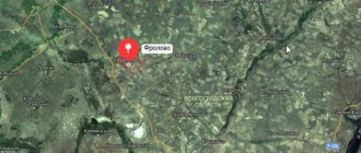
Map
| Kamensk-Uralsky: maps |
Kamensk-Uralsky: photo from space (Google Maps) Kamensk-Uralsky: photo from space (Microsoft Virtual Earth)
| Kamensk-Uralsky. Nearest cities. Distances in km. on the map (in brackets along roads) + direction. Using the hyperlink in the distance , you can get the route (information courtesy of the AutoTransInfo website) | |||
| 1 | Bogdanovich | 41 (103) | WITH |
| 2 | Kataysk | 42 (46) | IN |
| 3 | Beloyarsky | 48 (63) | NW |
| 4 | Sukhoi Log | 56 (119) | WITH |
| 5 | Zarechny | 57 (71) | NW |
| 6 | Elansky | 59 () | NE |
| 7 | Dalmatovo | 63 (69) | IN |
| 8 | Verkhneye Dubrovo | 64 () | NW |
| 9 | Bobrovsky | 64 (108) | NW |
| 10 | Sysert | 68 (130) | Z |
| 11 | Kamyshlov | 68 (144) | NE |
| 12 | Asbestos | 70 (87) | WITH |
| 13 | Aramil | 73 (124) | NW |
| 14 | Reftinsky | 74 (109) | WITH |
| 15 | Source | 75 () | NW |
| 16 | Big Source | 77 () | NW |
| 17 | Snezhinsk | 81 (119) | SW |
| 18 | Kunashak (Chelyabinsk region) | 82 (100) | YU |
| 19 | Malysheva | 83 (102) | WITH |
| 20 | Berezovsky | 86 (126) | NW |
| 21 | Mountain Shield | 91 () | Z |
| 22 | Ekaterinburg | 93 (110) | NW |
| 23 | Kasli | 93 (123) | SW |
| 24 | Monetary | 94 (147) | NW |
| 25 | Bulanash | 95 (235) | WITH |
| 26 | Pyshma | 100 (182) | NE |
| 27 | Upper Pyshma | 101 (133) | NW |
| 28 | Artyomovsky | 103 (227) | WITH |
| 29 | Ozyorsk | 105 (141) | SW |
| 30 | Polevskoy | 106 (166) | Z |
a brief description of
Located on the southeastern slope of the Middle Urals, at the confluence of the river. Kamenka in the river Iset (Ob basin), 100 km southeast of Yekaterinburg. Large railway node
Territory (sq. km): 142
Information about the city of Kamensk-Uralsky on the Russian Wikipedia site
Historical sketch
Known as the Zhelezinsky settlement, which in 1682 was assigned to the Dalmatovsky monastery.
In 1700, by decree of Peter I, the Kamensky Iron Foundry was founded (launched in 1701) - one of the oldest mining plants in Russia, producing cannons, mortars, cannonballs, etc. Name after the river. Kamenka.
At the end of the 19th century. center for trade in agricultural products.
During the pre-war five-year plans, it became a site for the construction of large industrial enterprises.
Workers' settlement since April 5, 1926. Since 1935, the city of Kamensk, since 1940, Kamensk-Uralsky.
It actively developed during the Great Patriotic War of 1941-45.
Municipal indicators
| Index | 1999 | 2001 | 2003 | 2005 |
| Demography | ||||
| Number of births, per 1000 population | 6.9 | 8.3 | 9.9 | 10.2 |
| Number of deaths, per 1000 population | 15.4 | 16.5 | 17.6 | 16.6 |
| Natural increase (decrease), per 1000 population | -8.5 | -8.2 | -7.7 | -6.4 |
| Standard of living of the population and social sphere | ||||
| Average monthly nominal accrued wages, rub. | 1381 | 3567 | 5862 | 8460 |
| Average housing area per inhabitant (at the end of the year), sq.m. | 19.4 | 19.7 | 20.1 | 20.3 |
| Number of preschool institutions, pcs. | 63 | 57 | 55 | 57 |
| Number of children in preschool institutions, thousand people | 6.6 | 6.3 | 6.5 | 6.9 |
| Enrollment of children in preschool educational institutions (at the end of the year), as a percentage of the number of children of the corresponding age, % | 76.8 | 74.2 | ||
| Number of daytime educational institutions (at the beginning of the school year), pcs. | 41 | 40 | 41 | 39 |
| Number of students in daytime educational institutions, thousand people | 25.2 | 22.3 | 19 | 16.1 |
| Number of doctors, people. | 668 | 645 | 675 | 631 |
| Number of nursing staff, people. | 2236 | 2188 | 2218 | 2123 |
| Number of hospital institutions, pcs. | 14 | 11 | 10 | 8 |
| Number of hospital beds, thousand units | 2.1 | 2 | 2 | 2 |
| Number of medical outpatient clinics, pcs. | 29 | 27 | 22 | 24 |
| Capacity of medical outpatient clinics, visits per shift, thousand units. | 8.6 | 8.7 | 6.5 | 6.4 |
| Number of registered crimes, pcs. | 6172 | 6116 | 4324 | 6285 |
| Persons who committed crimes were identified, persons. | 3039 | 2833 | 1665 | 1756 |
| Economy, industry | ||||
| Number of enterprises and organizations (at the end of the year), pcs. | 2153 | 2353 | 2406 | 2656 |
| Number of operating enterprises by type of activity: mining (at the end of the year), pcs. | 0 | |||
| Number of operating enterprises by type of activity: manufacturing (at the end of the year), pcs. | 86 | |||
| Number of operating enterprises by type of activity production and distribution of electricity, gas and water (at the end of the year), pcs. | 30 | |||
| Volume of shipped goods of own production by type of mining (in actual prices), million rubles. | 0 | |||
| Volume of shipped goods of own production by type of manufacturing (in actual prices), million rubles. | 64833 | |||
| Volume of shipped goods of own production by type of production and distribution of electricity, gas and water (in actual current prices), million rubles. | 2905.1 | |||
| Construction | ||||
| Volume of work performed by type of activity “Construction” (until 2004 - volume of work performed under construction contracts), million rubles. | 161.5 | 306.2 | 339.7 | 482 |
| Commissioning of residential buildings, thousand sq.m. of total area | 11 | 1.8 | 10.2 | 25.9 |
| Commissioning of residential buildings, apartments | 159 | 16 | 135 | 293 |
| Commissioning of preschool institutions, places | 0 | 0 | 0 | 0 |
| Commissioning of educational institutions, places | 0 | 0 | 0 | 0 |
| Commissioning of hospital facilities, beds | 0 | 0 | 0 | 0 |
| Commissioning of outpatient clinics, visits per shift | 0 | 0 | 0 | 0 |
| Transport | ||||
| Number of bus routes (in intracity traffic), pcs. | 21 | 22 | 29 | 27 |
| Number of tram routes, pcs. | 0 | |||
| Number of trolleybus routes, pcs. | 5 | 4 | ||
| Length of operational trolleybus lines (at the end of the year), km | 21.7 | 21.7 | ||
| Number of passengers transported by buses per year (in intracity traffic), million people. | 57.9 | 64.9 | 64.1 | 56.1 |
| Number of passengers transported by trams per year, million people. | 0 | |||
| Number of passengers transported by trolleybuses per year, million people. | 50 | 50.5 | 51.6 | |
| Connection | ||||
| Number of residential telephone sets of the city public telephone network, thousand units. | 21.1 | 25 | 26.9 | 36.9 |
| Number of payphones of the city telephone network (including universal ones), pcs. | 221 | 221 | ||
| Trade and services to the population | ||||
| Retail trade turnover (in actual prices), million rubles. | 1271 | 3378 | 5550 | 8178.1 |
| Retail trade turnover (in actual prices), per capita, rub. | 6590 | 17760 | 30060 | 44325.7 |
| Index of physical volume of retail trade turnover, % compared to the previous year | 103.8 | 110.3 | ||
| Public catering turnover (in actual prices), million rubles. | 77.9 | 259.4 | 444.6 | 632.4 |
| Index of physical volume of public catering turnover, % compared to the previous year | 117.1 | 112.1 | ||
| Number of stores, pavilions (at the end of the year), pcs. | 9 | 4 | ||
| Sales area of shops, pavilions (at the end of the year), sq.m. | 806 | 724 | ||
| Volume of paid services to the population (in actual prices), million rubles. | 284 | 659.2 | 1043.8 | 1670.1 |
| Volume of paid services to the population (in actual prices), per capita, rub. | 1472 | 3493 | 5585 | 9075.1 |
| Volume of household services to the population (in actual prices), million rubles. | 14.7 | 33.6 | 38.8 | 65.7 |
| Volume of household services to the population (in actual prices), per capita, rub. | 76 | 178 | 207.7 | 356.5 |
| Investments | ||||
| Investments in fixed assets (in actual prices), million rubles. | 363.7 | 1132 | 2813.7 | 2104.4 |
| Share of investments in fixed assets financed from budgetary funds in the total volume of investments, % | 2.2 | 2.8 | 5.9 | 6.8 |
Data sources:
- Regions of Russia. Main characteristics of the constituent entities of the Russian Federation: statistical collection. Goskomstat of Russia. - M:, 2003.
- Regions of Russia. Volume 1. Statistical collection. Goskomstat of Russia. - M:, 2001. p. 416
- Regions of Russia. Basic socio-economic indicators of cities. Statistical collection. Rosstat. - M:, 2005. p. 269
- Transport in Russia: Statistical collection. Goskomstat. - M:, 2003. pp. 112, 122
- Transport in Russia: Statistical collection. Rosstat. - M:, 2005. pp. 119, 129
- Regions of Russia. Basic socio-economic indicators of cities. 2006. Statistical collection. Rosstat. - M:, 2006. p. 265
Economy
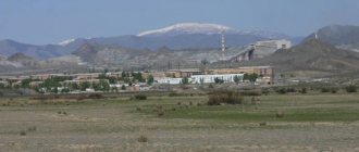
Kamensk-Uralsky is a large industrial center with a predominance of ferrous and non-ferrous metallurgy, mechanical engineering and the food industry.
Leading enterprises: plants - Sinarsky Pipe, Ural Aluminum, Metallurgical, Foundry, for processing non-ferrous metals.
Sewing and shoe factories. Radio engineering and electrical engineering enterprises, production of building materials.
Krasnogorsk Thermal Power Plant.
Potatoes and vegetables are grown in the Kamensky district. Dairy farming.
Main enterprises
PIPE PRODUCTION
JSC Sinarsky Pipe Plant
623401, Sverdlovsk region, Kamensk-Uralsky, Zavodskoy proezd, 1
Offers:
steel pipes, cast iron pipes, titanium alloy pipes, tape, cast iron and steel castings
NON-FERROUS METALLURGY
OJSC "Kamensk-Uralsky Kamensk-Uralsky Metallurgical Plant"
623405, Sverdlovsk region, Kamensk-Uralsky, st.
Zavodskaya, 5 Offers:
ingots, flat rolled aluminum alloys, extruded products, welded pipes made of aluminum alloys and steel, light alloy drill pipes, rods, wire
Ural aluminum
623406, Sverdlovsk region, Kamensk-Uralsky, st.
Zavodskaya, 4 Offers:
steel, electric steel, primary aluminum, alumina, silicon, steel castings, cast iron, grinding balls
Culture, science, education
General technical faculty of the Ural Technical University.
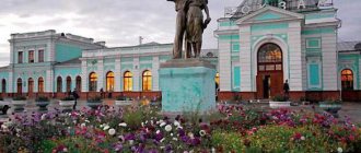
Drama Theater. Museum of Local Lore.
Universities of the city
Kamensk-Uralsky branch of the Ural Institute of Economics, Management and Law
623408, Sverdlovsk region, Kamensk-Uralsky, st. Belinskogo, 1
Polytechnic Institute of the Ural State Technical University - UPI named after. the first President of Russia B.N. Yeltsin, Kamensk-Uralsk
623400, Sverdlovsk region, Kamensk-Uralsky, st. Lenina, 34 WWW: https://upi.kamensktel.ru/
Ural State Economic University (Kamensk-Ural branch)
623408, Sverdlovsk region, Kamensk-Uralsky, Aluminum street, 37-a WWW: https://www.kufeu.ru/
Museums, galleries, exhibition halls
Kamensk-Ural Museum of Local Lore named after.
AND I. Styazhkina 623409, Sverdlovsk region, Kamensk-Uralsky, pl. October 25 Phone(s): (3439) 324-461 (3439) 323-472 (ex.bureau) Museum of the History of Rural Culture 623462, Sverdlovsk region, Kamensky district, urban-type settlement Martyush, st. Lenina, 11 Phone(s): (34378) 7-4425
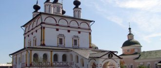
Architecture, sights
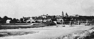
The city's territory extends from northwest to southeast for more than 20 km. The old part of Kamensk-Uralsk is located between the Iset and Kamenka rivers.
Office building of the Kamensky State Iron Foundry (19th century, architect M.P. Malakhov).
The modern city is distinguished by the disunity of residential areas located near industrial enterprises and representing separate villages surrounding the old city.
There are natural monuments in the area: rocks - Bogatyryok (on the left bank of the Kamenka River, within the city), Stone Gates (right bank of the Iset River), Three Caves (left bank of the Iset River), etc.
| Population by year (thousands of inhabitants) | |||||||
| 1926 | 5 | 1976 | 182 | 2001 | 189.2 | 2013 | 172.1 |
| 1931 | 8.7 | 1979 | 187.4 | 2003 | 186.2 | 2014 | 171.5 |
| 1939 | 50.9 | 1982 | 193 | 2005 | 183.3 | 2015 | 170.9 |
| 1956 | 122 | 1986 | 202 | 2006 | 182.5 | 2016 | 170.2 |
| 1959 | 141.0 | 1989 | 207.8 | 2007 | 181.6 | 2017 | 169.9 |
| 1962 | 152 | 1992 | 208.7 | 2008 | 180.9 | 2018 | 169.0 |
| 1967 | 161 | 1996 | 195 | 2010 | 179.1 | 2019 | 167.4 |
| 1970 | 169.3 | 1998 | 193.0 | 2011 | 174.7 | 2020 | 166.1 |
| 1973 | 175 | 2000 | 190.6 | 2012 | 173.1 | 2021 | 164.0 |
NUDE #1
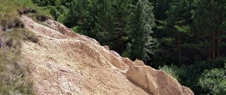
On the cliff, between the buildings of the former monastery and the electromechanical plant, limestone ridges are clearly visible. Even elementary schoolchildren know that limestone is nothing more than fossilized sea silt, consisting of microscopic calcareous skeletons of marine organisms. This means that there once was a sea in our area.
A close look at the limestone outcrops reveals layers overflowing with the shells and skeletal tubes of coral polyps. And here is a block of stone, entirely consisting of thin, 3-4 mm tubes. It is part of a reef created by corals.
Using reference literature, you can easily determine the lifespan of fossilized skeletons of corals of the genera Siringopora and Lithostrocyon, and brachiopod shells. It turns out that local fossils, and therefore the limestones containing them, are 320 million years old.
Thus, we found out that 320 million years ago at this point on the globe there was a roaring sea, at the bottom of which layer after layer of calcareous silt was deposited, burying the remains of marine organisms - shells and corallites.
The question arises. If the layers at the bottom of the sea were deposited horizontally or hollowly, then why do we find limestone layers inclined (or, as geologists call them, falling) to the horizon at an angle of 30-35 degrees? Inclined strata indicate powerful mountain-building processes. This is the western wing of a rock fold - an anticline, one of the millions that form the ancient Ural mountainous country.
In limestone outcrops one can also find such evidence of mountain-building processes as a “slip surface”. It is a polished surface of a stone, resulting from the movement of one block relative to another along a crack.
Another geological object is a karst niche formed when limestone is dissolved by groundwater (the so-called karst phenomena).
The black layer of flint in the limestone is the remains of the flint skeletons of microscopic marine organisms.
NUDE #4
In the place where the Kamenka River turns south, outcrops of loose clastic rocks appear on its steep slopes, and another magnificent panorama opens to the inquisitive eyes of interested observers for studying the geological history of the Earth. We are talking about the so-called “weathering crust”, which looks most impressive in the deep ravine going down to the river from Kunavina Street.
This nameless ravine literally cut through the thickness of multi-colored clays. If here, in the ravine, they have a gray, red, purple and brown color, then in the area of K. Marx Street, seemingly nearby, there are already clays of other colors - light yellow and white. Clays contain a large amount of crushed stone of various types. Unlike limestone and coal-bearing rocks crumpled into folds, variegated clays lie horizontally, which is easy to notice if you look closely at the layers of crushed stone.
They were formed as a result of the intense destruction of sedimentary and igneous rocks of the Paleozoic mountains during the Mesozoic era, when the climate on our planet became very hot and humid. The processes that led to the emergence of the “weathering crust” are also associated with the formation of deposits of brown iron ore and bauxite. For the needs of the state-owned iron foundry, until 1917, we developed numerous deposits of iron ore, individual nests of which were discovered north of the river valley, where Pobedy Avenue now stretches, as well as in three mines located near the mouth of Kamenka: Razgulyaevsky, Zakamenny and Polyaninovsky.
The “weathering crust” rocks were formed in the first half of the Cretaceous period of the Mesozoic era, approximately 140-100 million years ago.
Reflecting on the geological past of our region, we are forced to admit that even today not all of its pages are easily explained and understood without any reservations. If the Kamensk limestones are 320 million years old, and the clays are 140-100, then why don’t we find any other rocks of intermediate age? The huge chronological gap most likely resulted from the fact that there was no accumulation of sedimentary rocks here for a long time. The course “Historical Geology” gives, for example, the following answer to the question. Over the course of 65-70 million years, mountain ranges slowly rose up on the site of the current West Siberian Lowland and the Urals. It took another 90 million years for the once high (like the modern Caucasus) Ural mountainous country to be destroyed and turned into a plain by the sun, water and wind. Therefore, the entire West Siberian Lowland is composed of sands and clays formed as a result of the processes of weathering and washing away rocks of ancient ridges.
The roots of these mountains that disappeared from the face of the Earth, exposed by the valleys of the Iset, Kamenka and Kamyshenka rivers, are what we see today, surveying the surrounding area and natural monuments of our native land.
NUDE #5
In the upper reaches of the ravine, under modern loams, greenish sands were exposed. At the end of the Cretaceous - beginning of the Paleogene periods, our area, like the entire eastern slope of the Ural Range, sank again, turning into the seabed. The depressions of the Mesozoic relief were filled with new sediments: clays, siliceous rocks - opoka and sands. Greenish glauconitic sands are 60-40 million years old. The sea, which rushed here from Western Siberia, left another reminder of itself - white quartz sands. Occurring in the area of the Silicate village, the villages of Kodinka and Pirogovaya.
It is amazing that the huge ravine owes its birth to a modest spring, which hardly makes its way to the surface from the aquifers of the earth.
NUDE #3
We move along the river bed. Closer to the turn of Kamenka to the south, among the dark carbonaceous rocks of the coal-bearing strata, bright yellow spots of granite-porphyry catch the eye. This is a new, igneous rock that is younger in origin than the limestones and coal-bearing rocks that are already familiar to us.
Mountain-building processes that began at the end of the Middle Carboniferous era (about 300 million years ago) squeezed out small portions of magma from the bowels of the earth, which penetrated into the rocks of the coal-bearing strata, but due to their insignificance and low temperature, they were not able to break through to the surface of the earth, and frozen in the depths. The scientific name for such formations is igneous intrusions. The continuation of such an intrusion is visible below the mouth of the ravine.