Lyubertsy is the outskirts of the capital, sharing a common border with Moscow. If you look at the map of Lyubertsy from a satellite, you will notice that the city is located almost within walking distance from the Tagansko-Krasnopresnenskaya line of the Moscow metro. It is only about 20 km away from the Kazansky railway station.
On the site of the modern city there were previously rural lands; in the 17th century. the settlements were presented to Peter III. And only at the end of the 19th century, when a railway was laid through the settlement, which can be seen on the map of Lyubertsy with diagrams, the settlement began to acquire an industrial orientation. Small villages were united by the Ukhtomsky plant, workers began to arrive, and the settlement gradually grew.
Nowadays, the city is a railway junction on the Ryazan direction with developed industry and a population of more than 180 thousand. Lyubertsy is characterized by very dense buildings; the territory of the city, accommodating such a large number of residents, is only 12 km2.
You can view the location of the city, its neighborhoods and main objects on the map of Lyubertsy by district. The city is completely urbanized and has no ponds or forests. The only green area is the Park of Culture.
Where is Lyubertsy?
Lyubertsy is the administrative center of the city of regional subordination of Lyubertsy and the urban district of Lyubertsy, which is located in the Moscow region.
Lyubertsy is the sixth largest city in the Moscow region and the first in density. The approximate population is 200 thousand people. The total area of the city is 12 square kilometers. The climate in Lyubertsy is temperate, characterized by cold winters and warm summers. The annual precipitation rate is 660 mm. Lyubertsy is in the same time zone as Moscow, the offset relative to Coordinated Universal Time (UTC) is +3.
Hymn
The city of Lyubertsy is a brother to the cities that stand Among the beauties of the Moscow region, For great deeds, for churches that keep the course of the history of our country. He forged victories, was proficient in crafts For Russia for centuries on end. In it Yesenin read poetry with inspiration, In it Gagarin's glory lives.
Chorus:
City of Lyubertsy, Lyubertsy, Lyubertsy, Your name rhymes with love, Prosperous, live. You are worthy of love. The people of Lyubertsy admire you. City of Lyubertsy, Lyubertsy, Lyubertsy, Beauty is your eternal companion, Live prosperously. For work and love, Your name will not be forgotten forever.
And in the dawn rays in the parks the birds are singing, the avenue is silvered by the river... Maybe you will find this in other cities, but Lyubertsy is not dearer to us. A city with a bright destiny, may a golden ray of Glory always shine above you, And may every working day in your life be friendly with your beauty.
Chorus:
City of Lyubertsy, Lyubertsy, Lyubertsy, Your name rhymes with love, Prosperous, live. You are worthy of love. The people of Lyubertsy admire you. City of Lyubertsy, Lyubertsy, Lyubertsy, Beauty is your eternal companion, Live prosperously. For work and love, Your name will not be forgotten forever.
Words by V. Shurbakov, music by Y. Verizhnikov.
Accepted September 8, 2011.
Lyubertsy Airport
Lyubertsy does not have its own airport. The nearest international civil airport is Domodedovo. The distance from Lyubertsy to Domodedovo is 35 km. The airport has the status of a federal facility and is one of the four main airports in Moscow. It ranks second in terms of passenger traffic in the Russian Federation. The airport operates 24/7 every day. Included in the TOP 20 busiest airports in Europe.
The airport serves aircraft of major Russian and international airlines: Aeroflot, S7 Airlines, EgyptAir, Brussels Airlines, Lufthansa, Red Wings Airlines. Popular destinations for regular and charter flights: Krasnoyarsk, Warsaw, Tokyo, Madrid, St. Petersburg. The annual passenger traffic is more than 29 million people.
Coat of arms
The coat of arms of Lyubertsy is presented in the form of a French shield. It depicts a narrow concave red point in an azure field. It is inclined to the right of the viewer and at the bottom it expands to the edges of the shield. It has a thin border tapering upward. The top of the point is covered with a gold star with five rays. They lengthen from bottom to top. The coat of arms symbolizes the space industry, helicopter manufacturing, science, and education.
The artistic composition is included in the State Heraldic Register of the Russian Federation under No. 3474. Approved by the decision of the Council of Deputies of the Lyubertsy urban settlement No. 119/4 dated June 29, 2007.
Train Station
The Lyubertsy-1 railway station is a junction station of the Kazan and Ryazan directions of the Moscow Railway. Type of railway station: freight. In terms of volume of work it belongs to class 1. The railway station is located at st. Volkovskaya, 9, in the very center of the city, near the large shopping complex “Labyrinth”.
Electric trains depart from the Lyubertsy-1 railway station to the following directions: Moscow, Ryazan, Cherusti.
Also in Lyubertsy there is a railway station “Lyubertsy-2” - a station in the Kazan direction of the Moscow Railway. The type of railway station is local.
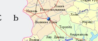
Map of Lyubertsy with streets
The city is connected to Moscow by railroad and highways. The railway station and bus station, as the map of Lyubertsy with streets shows, are located in the area of Volkovskaya Street at its intersection with Smirnovskaya.
The main transport artery is Oktyabrsky Prospekt, which is also part of the regional highway R-105. The outskirts of Lyubertsy are touched by the M-5 Ural federal highway. These are busy, wide highways along which city transport, transit trucks and cars travel. If you zoom in on the map of Lyubertsy with streets and houses, then in the microdistrict called “Town B” you can see where the metro station exits are located.
Main streets of the city:
- Volkovskaya;
- Initiative;
- Komsomolskaya;
- Smirnovskaya;
- Kirov;
- October prospect;
- Victory Avenue.
Both the central and secondary highways of Lyubertsy have very dense buildings. High-rise buildings are lined up along the streets close to each other, which can be seen on a map of Lyubertsy with houses. The first floors of most residential buildings are occupied by offices and shops.
Automobile highways
The following roads pass through Lyubertsy:
- M5 "Ural" is a federal highway with a total length of 1879 km. It is part of the European route E30 and the Asian routes AH6 and AH7. The route passes through the following regions of Russia: Moscow region, Samara region, Bashkortostan, Tatarstan, Orenburg region, Chelyabinsk region, Mordovia, Penza region. The road surface of the M-5 route is asphalt.
- MKAD - Lyubertsy borders on the Moscow Ring Road - a traffic-lightless ring road, the total length of which is 109 km. The road surface of the Moscow Ring Road is asphalt concrete.
- E115 is a European route that passes only through the territory of the Russian Federation. The total length of the highway is 1,730 km.
DRANCY – FRENCH SIBLIN CITY Lyubertsy
Pbratymov Street - many of our readers have probably heard about it or been to this microdistrict of high-rise buildings in the north of Lyubertsy. However, not every Lyubertsy resident knows why this street got its “name”.
And this story began half a century ago: it was then that the foundation was laid for further contacts, exchange of delegations and cooperation between the sister cities of Lyubertsy (USSR) and Drancy (France).
RESIDENTS OF COVENTRY TO THE DEFENSERS OF STALINGRAD
Officially, 1944 is considered the starting point for the movement of twin cities (twin cities). But this idea originated even earlier: in the British city of Coventry, after the terrible night of November 14, 1940, when 12 hours of German bombing killed 554 people and destroyed three-quarters of the houses in the city center. Two years later, the city of Stalingrad was subjected to gigantic destruction by the Nazis.
It was then that a left-wing movement arose in Coventry, calling on Britain to step up assistance to the Soviet Union. And the city itself did a lot to send help to the “Russians at the front,” and this became a touching event. 830 Coventry women paid six pence each for the right to embroider their signature on the tablecloth. And in total the population of Coventry then collected a considerable sum of 4,516 pounds for the purchase of X-ray machines for the Red Army; Children also took part in collecting money. The tablecloth from Coventry, along with the message “A little help is better than a lot of sympathy” and with the donations collected, was transferred through the USSR Embassy in London to Stalingrad. In response, hundreds of surviving women of Stalingrad sent an album with their signatures to Coventry. In 1944, the bonds of friendship between these two cities were formalized; and the Coventry tablecloth is still kept in the Museum of the Battle of Stalingrad in Volgograd as a priceless relic.
In 1957, representatives of sister cities created the World Federation of Twin Cities (WFTG), which in 1963 declared the last Sunday in April as World Sister Cities Day. In 1964, the twin cities of the USSR united into the Association for Relations between Soviet and Foreign Cities, which became part of the All-Union Federal Penitentiary Group. Later, sister cities Lyubertsy and Drancy were also included in this Association.
A CITY ON THE OUTBAR OF PARIS
It’s gratifying to know, isn’t it, that just 11 kilometers from the center of Paris there is the city of Drancy, which for us, Lyubertsy, has been for half a century not completely “foreign,” but officially related to our Lyubertsy. 66.5 thousand residents of Drancy get up every morning with the hope of a successful day, make plans, rush to work, study or on dates with loved ones, and each of them, like us, probably dreams of happiness and peace.
The city of Drancy is located in the Ile-de-France region (translated from French as the Island of France), in the central part of the Paris Basin, between the Seine, Marne and Oise rivers. The territory of Ile-de-France (with its center in Paris) is often called the core of the French state. The Ile-de-France region includes 8 departments, one of which, Seine-Saint-Denis, includes the city of Drancy. Small in area, the department of Seine-Saint-Denis ranks second in France in terms of population density.
The history of Drancy has been known since the Gallo-Roman era (3rd century AD). In the Middle Ages, this region subsisted on agriculture: cereals and grapes were grown on the plains, and cattle were grazed in the meadows. In the 16th-17th centuries, Drancy belonged to the Seguier family, who built a castle on this land. In the 19th century, Baron de Ladoucette built a large park in Drancy. For hundreds of years, the family of barons de Ladoucette kept the winery for their pleasure and prestige. Now a citizen of France and a descendant of the famous family, Baron Patrick de Ladoucette, is widely known not only in his Fatherland, but throughout the world. The first of the generations of his aristocratic family, Patrick de Ladoucette chose winemaking as his main occupation. In 1975, he released his wine “Baron de L”, which provided him with recognition for many years. Today, Baron de Ladoucette is one of the most successful creators of expensive wines in the world: he owns 8 brands of wines and champagne. Most of his wines are made from Sauvignon Blanc grapes grown in the Loire River valley, where the baron’s luxurious castle is located...
The annual summer Lendy fair, held on the plain between the city of Saint-Denis and Paris, to which sellers and buyers flocked from all over Europe, also had a positive effect on the development of Drancy. With the creation of railways, active economic growth began in the region, which contributed to its demographic development. During the war between France and Prussia, in 1870, Drancy was almost completely destroyed. In the next century, amid a housing crisis exacerbated by the military destruction of the First World War, the state was forced to subsidize low-cost housing construction. One progressive example of this was the La Muette residential complex in Drancy, built in 1930-1934. designed by the architects Eugene Baudouin and Marcel Lauds. It was densely built up with 15-story single-section “tower” buildings in a row, each of which was adjacent to two 3-4-story sectional buildings. In construction, flow-based organization of work was used for the first time; a metal and reinforced concrete frame was used with filling from lightweight prefabricated concrete slabs.
CAMP WINDOWS TO ETERNITY
In 1940, the La Muette complex was confiscated by the German occupiers: used as police barracks, then as the primary detention center in the Paris region for the isolation of Jews, Gypsies and anyone planned to be deported from France. This transit concentration camp in Drancy and a transit point for sending people to death camps became one of the most shameful and terrible pages in the list of Nazi atrocities. 70 thousand Jews passed through the Drancy camp during the Second World War, 61 thousand of them were deported to the Auschwitz and Sobibor concentration camps. The famous French poet and artist Max Jacob also died in the Drancy concentration camp; Many representatives of the Russian emigration in France passed through him and later died in Nazi concentration camps. The prisoners of the Drancy concentration camp were actively helped by Mother Maria, the nun Maria, and in the world by an emigrant from Russia Elizaveta Skobtseva, after her first husband Kuzmina-Karavaeva, the heroine of the Resistance movement, who died in the Ravensbrück concentration camp in March 1945 - a week before the liberation of its prisoners by the Red Army . On August 17, 1944, Allied troops entered the Drancy camp, where they found only 2 thousand people alive.
After the war, the La Muette complex again became a residential area, where in 1976 a monument to the victims of Nazism was erected, and in 1988 a commemorative railway carriage was installed - one of those in which French deportees were taken to Auschwitz. On September 21, 2012, in Drancy, the opening ceremony of the Holocaust memorial was held by French President Francois Hollande, at which the head of state called the transit camp in Drancy during the war years “the threshold of hell.” President Hollande stressed the need to pass on the memory of the terrible crimes of Nazism to future generations, calling learning from the past “a way to prevent it from happening again.”
MAURICE NIELE – HERO OF THE RESISTANCE AND MAYOR OF DRANCY
The fact that Lyubertsy and Drancy became sister cities was greatly facilitated, of course, by the heroic past and civic position of Maurice Niel, the mayor of the city of Drancy since 1959, who was elected to this post 7 times (!) from then to 1997; his positive attitude towards our country, which did so much for the Victory over fascism.
The future statesman and politician, member of the French Communist Party, Maurice Niel was born in Paris on August 12, 1919 in a working-class family. In his youth, he also worked as a milling machine operator at one of the Parisian enterprises. In 1939 he was mobilized into the French army, and at the beginning of the war with Germany he was captured and escaped from a prisoner of war camp. Maurice Niel joined the Occupation Resistance movement from the very beginning. Perhaps even then he turned his attention to the Russians, who fought against fascism shoulder to shoulder with the French: 3 thousand Soviet citizens who ended up in France, and many emigrants from Russia who lived there, also took part in the Resistance movement. In 1941, Maurice Niel was again captured by the Nazis, again fled and joined the partisan detachment - the “Maquis”. Thanks to his personal courage, he soon became the commander of a partisan detachment, at the head of which he participated in the liberation of the city of Bordeaux from the invaders.
After the end of the war, Maurice Niel returned to Paris. In 1986, he became a deputy of the French National Assembly from the department of Seine-Saint-Denis on the lists of the French Communist Party. An officer of the Legion of Honor and the Order of Merit, Maurice Niel was also awarded the Military Cross, the Resistance Medal (France), the Cross of the Resistance Volunteers and the Veteran's Cross Medal. He passed away on December 5, 2001 in the city of Bobigny in the Seine-Saint-Denis department near Paris. But the memory of this most worthy man is alive not only in France, but also on the land of Lyubertsy.
From December 2001 to this day, the head of the city of Drancy is Jean-Christophe Lagarde (born in 1967), a member of the National Assembly of the French Republic.
Our story about the stay of delegations from the French city of Drancy on Lyubertsy land is in one of the upcoming issues of the newspaper.
Tatiana SAVINA
Reproduction of this text or fragments from it in printed publications and in electronic form is only with the written consent of the author.
The editors of the "Lyubertsy newspaper" will be grateful to eyewitnesses of the events of the 1960s - 1970s who provided photographs for copying and provided additional information on the topic "Drancy and Lyubertsy - sister cities." Contact phone number: 8-915-101-67-07
What is Lyubertsy known for?
- Among the city's attractions, one should highlight the House of N. A. Kruming, the American owner of a plant in Lyubertsy. Previously, social events with a large number of invited guests were often held here. One of these guests was V.I. Lenin in 1920. Today a museum is opened in the building.
- In 1995, the Chapel of All Saints was built in the city - in memory of those who died who defended their homeland. The chapel belongs to the Church of the Transfiguration of the Lord.
- Among the historical architectural monuments in the city, it is worth noting the Zenino Estate, which was named in honor of Zinaida Kagulskaya, the daughter of Sergei Rumyantsev. The estate is divided into two parts: on one side there is a mental institution, on the other there is a three-story estate.
- Between the Moskva River and Pekhorka rivers there is the Tomilino Forest Park, which is 14 km long and 5 km wide. The area of the forest park is 3,500 hectares. More than 3,000 species of bushes, plants and fruits grow on the territory of the Tomilino Forest Park. There is also a monastery within the park.
Story
The history of Lyubertsy begins for the first time with the mention of the village of Liberitsa-Nazarovo in 1621. The first part of the name is from the river, the second is from the name of the owner. The official founding date of the settlement is 1623. Since 1705 it belonged to Prince A. Menshikov, who renamed it Preobrazhenskoye. Soon it was given its modern name.
In the 19th century, a railway was built there. Rapid growth of industry and population began. The development of production in the village was due to the construction of the steam engine factory of Thomas Purdais. The object appeared at the beginning of the 20th century. The revolution of 1905 was accompanied by worker conflicts.
After the advent of Soviet power, in 1925, Lyubertsy was given the status of a city. It includes the villages of Panki, Podosinki, and Mikhelson. After the end of World War II, it developed rapidly. During the Russian Federation it became one of the most densely populated areas of the Moscow region.