Government departments
System of government bodies power is determined by the Charter of the joint stock company. (1997). State power is exercised by the State. Duma of the A. O., governor, regional administration, other state bodies. authorities formed in accordance with the Charter of the region. State Duma A. o. - the highest legislator. (representative) government body. regional authorities. Consists of 29 deputies elected for a period of 5 years. The regional administration is the highest executive. state body authorities. The administration is formed and headed by the governor of the autonomous region, vested with powers by the regional Duma on the proposal of the President of the Russian Federation.
Nature
Territory of A. o. flat, located within the Caspian lowland. 3 /4 A. o. lies below the level of the World Ocean (altitude from –2.7 m in the north to –27 m in the south - the lowest place in Europe). The relief includes salt-dome uplifts (Mount Bolshoye Bogdo, 149 m, the highest point of the region) and the so-called. Baer mounds, which are sandy-clayey parallel sublatitudinal ridges (length up to 25 km, height 10–45 m), separated by regular intervals (width about 1 km); oval hills in the Volga delta. In the east are the sands of Batpaisagyr. In some places there are salt marshes and sand dunes. On the Volga-Akhtuba floodplain there are riverbed ridges and high sandy ridges. There are known oil and gas fields - the Astrakhan gas condensate field, salts (main sample in Lake Baskunchak).
Volga in the lower reaches. Photo by A. I. Nagaev
Climate of A. o. (despite its proximity to the sea) sharply continental, with frosty, windy winters and hot, dry summers, with a large range of annual and daily temperatures. Wed. January temperatures from –10 °C in the north to –6 °C in the south, July approx. 25°C. Precipitation approx. 200 mm per year. In spring and summer there are dry winds. The duration of the growing season is more than 200 days.
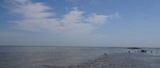
The main river, the Volga (with Akhtuba), does not accept the territory of the Autonomous Oblast. not a single influx, but loses a lot of water to evaporation. In the lower reaches of the Volga, the Volga-Akhtuba floodplain stands out with many channels, floodplain lakes and oxbow lakes, forming a fertile, annually flooded strip of land (over 250 km long). In the Volga delta, St. 800 branches (the largest are Bakhtemir, Bolda, Buzan, etc.) and channels. There are many salt lakes, the largest is Baskunchak. The brine and mud of lakes Solenoye and Tinaki are used for medicinal purposes. Freshwater lakes (ilmeni) in the floodplain and delta of the Volga serve as spawning grounds for fish.
Most of the region is located in the semi-desert zone, except for the south. part belonging to the desert zone. Grows in rarefied conditions. The cover is dominated by cereals, wormwood, and solyanka, growing on light chestnut solonetzic and brown soils. In the Volga-Akhtuba floodplain and in the Volga delta there are meadows on alluvial soils. Significant areas are occupied by floodplain forests and reed thickets along the banks of numerous rivers. ducts and ilmens. In the semi-desert, the most common animals are saiga, rodents (gophers, jerboas, gerbils, etc.), wild boar, and eagles. The Volga delta is characterized by white herons and pelicans; Migratory waterfowl are numerous in spring and autumn. In the Volga - approx. 50 species of fish, among them approx. 30 commercial (including sturgeon). To preserve the unique flora and fauna of the Volga delta, the Astrakhan Nature Reserve (one of the first Russian nature reserves) was created.
Natural conditions for the population's life are moderately and unfavorable. Ecological The situation is contrasting, especially acute in the region of the Astrakhan gas complex. Around Astrakhan there is a stable zone of general contamination of the territory with an area of approx. 900 km2. The amount of emissions into the atmosphere was (2003) 119 thousand tons. Ecological. problems are also associated with an increase in the level of the Caspian sea, transboundary pollution of the rivers of the Volga basin, etc.
Map of the Astrakhan region with cities, districts and villages
| 1. Astrakhan | 5. Nachalovo village (Privolzhsky district) | 9. Ilyinka district (Ikryaninsky district) | 13. Volodarsky district (Volodarsky district) |
| 2. Krasny Yar village (Krasnoyarsk region) | 6. Cherny Yar s. (Chernoyarsk district) | 10. Verkhniy Baskunchak r.p. (Akhtubinsky district) | 14. Ikryanoye village (Ikryaninsky district) |
| 3. Kirovsky town (Kamyzyaksky district) | 7. Kharabali city (Kharabali district) | 11. Akhtubinsk city (Akhtubinsky district) | 15. Enotaevka village (Enotaevsky district) |
| 4. Liman rp (Limansky district) | 8. Volga-Caspian town (Kamyzyaksky district) | 12. Nizhny Baskunchak r.p. (Akhtubinsky district) | 16. Kamyzyak city (Kamyzyak district) |
Satellite map of the Astrakhan region
Switching between the satellite map of the Astrakhan region and the schematic one is done in the lower left corner of the interactive map.
Astrakhan region - Wikipedia:
Date of formation of the Astrakhan region:
December 27, 1943
Population of the Astrakhan region:
997,778 people.
(January 1, 2022) Telephone code of the Astrakhan region:
851
Area of the Astrakhan region:
44,100 km²
Vehicle code of the Astrakhan region:
30
Districts of the Astrakhan region:
Akhtubinsky • Volodarsky • Enotaevsky • Ikryaninsky • Kamyzyaksky • Krasnoyarsky • Limansky • Narimanovsky • Privolzhsky • Kharabalinsky • Chernoyarsky.
Cities of the Astrakhan region - list of cities in alphabetical order:
Population of cities in the Astrakhan region in 2017.
City of Astrakhan
founded in 1558.
The population of the city is 532,504 people. The city of Akhtubinsk
was founded in 1793.
The population of the city is 37883 people. The city of Znamensk
was founded in 1948.
The population of the city is 26934 people. The city of Kamyzyak
was founded in 1560.
The population of the city is 16,077 people. The city of Narimanov
was founded in 1963.
The population of the city is 11,118 people. The city of Kharabali
was founded in 1789. The population of the city is 18,031 people.
Astrakhan region
is located in southern Russia, where the Volga River flows into the Caspian Sea, forming one of the largest river deltas in Europe. Historically, Sarai-Batu, the original capital of the Golden Horde, was located on this territory.
The administrative center of the Astrakhan region is the city of Astrakhan
, which originated as a trading center for the Golden Horde and was annexed to Russia by Ivan the Terrible in the mid-16th century. Today the city is famous for its white Kremlin - the southernmost Kremlin in all of Russia.
The best time to visit the Astrakhan region is July and August, when lotuses bloom in the Volga delta and the famous Astrakhan watermelons are harvested. The region is also associated with black caviar from the Caspian Sea.
City of Astrakhan
was founded in the second half of the 13th century. Being located near the mouth of the Volga River, it quickly became an important trading city, and in the mid-15th century it became the capital of the Astrakhan Khanate, the successor state of the Golden Horde. It became part of Russia under Ivan the Terrible, who was responsible for founding the city's most famous landmark, the Astrakhan Kremlin. Astrakhan was named the Historical City of Russia.
Climate of the Astrakhan region
– sharply continental, characterized by high temperatures in summer and low temperatures in winter. Temperatures in summer - from +25 to +28 C. Temperatures in winter - -5...-9 C.
Most attractions in the city of Astrakhan
, whose history lasts 450 years. The buildings of the city date back to the 16th-20th centuries. The main attraction of the city is the Astrakhan Kremlin, built in the 16th century, the walls of which are still preserved. The Astrakhan region is also famous for its natural monument - Lake Baskunchak, the main deposit of table salt.
Population
B. h. population of A. o. are Russians (70%, 2002 census), Kazakhs (14.2%) and Tatars (7%, including Astrakhan Tatars 0.2%). Other groups include Ukrainians (1.3%), Chechens (1%), Azerbaijanis (0.8%), Kalmyks (0.7%), Armenians (0.6%), Nogais (0.5%), Avars (0.4%), Lezgins (0.4%), Dargins (0.4%). Since 1997 it has been characterized by natural population decline: mortality (15 per 1000 inhabitants, 2004) exceeds the birth rate (12.4 per 1000 inhabitants); infant mortality rate 12.6 per 1000 live births (2003). The share of women is 53%. The share of the population under working age (up to 16 years) is 19.1%, over working age 18.5%. In 2003, life expectancy was 65.4 years (men - 59.2, women - 72.2). Since the 1990s The region was characterized by a steady migration influx of population, mainly from former countries USSR, which practically ceased in 2003 (migration growth rate -1 per 10 thousand inhabitants). Wed. density of us. 22.6 people/km2. The Volga delta is the most densely populated. Gor. us. 67.0% (2005; 68.0% in 1989, 52% in 1959). St. 1/2 of us. region and approx. 3/4 of the townspeople live in Astrakhan (501.3 thousand people, 2005). Dr. significant cities (2005, thousand people): Akhtubinsk (44.2), Znamensk (32.1).
Historical sketch
The most ancient monuments on the territory of A. o. are represented by Mesolithic and Neolithic sites belonging to the Seroglazov culture. During the Eneolithic - Early Bronze Age, a productive economy (mainly sheep farming) spread throughout the region, apparently brought by the population who moved from the East. Caspian region. Monuments of A. o. of this time belong to the Yamnaya culture (probably included in the zone of its formation). The Bronze Age is represented here by the Catacomb culture and the Srubnaya culture. By the early Iron Age in A. o. nomadic cattle breeding spread. The oldest people known by name on the territory of A. o. – Sauromatians (mid 1st millennium BC). In the last centuries of the 1st millennium BC. e. and in the 1st half. 1st millennium AD e. territory of A. o. was controlled by Sarmatian groups, including the Aorsi. One of the routes of the Great Silk Road passed along it. During the era of the Great Migration of Peoples through A. o. Turkic-speaking nomads - Huns, Avars, Turks, Khazars, etc. - migrated from Asia to Europe.
In the early Middle Ages, on the territory of A. o. The Volga Route, which connected the Center, also began to play an important role. Asia from the East Europe. In the 7th–10th centuries. the region was part of the Khazar Kaganate; its capital, Itil, was located in the lower reaches of the Volga (judging by written sources, a huge city, traces of which have not been found). Monuments of the Khazar era are represented by burial mounds of the Sokolovo type. Finds from this period are known at the Samosdelka settlement, the most expressive layers of which date back to the 10th–12th centuries. (probably the Polovtsian city of Saksin) and to the Golden Horde time. In the end 10 – start 13th centuries The decisive role in the region was played by nomads - the Pechenegs and Cumans. From ser. 13th century the lower reaches of the Volga became the center of the Golden Horde, the cities of Sarai, Khadzhi-Tarkhan (Astrakhan), and others arose here. After the collapse of the Golden Horde, the Great Horde existed on the right bank of the lower Volga, then the Astrakhan Khanate, and on the left bank - the Nogai Horde. The Astrakhan campaigns led to the inclusion of the Astrakhan Khanate into the Rus. state, from the 2nd half. 16th century vassal dependence on Russian. The king was also recognized by the biys of the Nogai Horde. At 17 – beginning. 18th centuries the region was one of the centers of the Razin uprising of 1670–1671 and the center of the Astrakhan uprising of 1705–06.
The territory of modern A. o. was part of the Kazan province (1708–17), the Astrakhan province (1717–85 and 1796–1928), the Caucasian governorship (1785–96; divided into Autonomous Oblast and the Caucasus region), the Lower Volga region. (1928), Lower Volga region (1928–1934), Stalingrad region (1934–1936), Stalingrad region. (1936–43). 12/27/1943 from the Stalingrad region. An independent Astrakhan region was created; in 1943–57 it included a number of modern districts. Kalmykia.
Map of the Astrakhan region from satellite
The area of the Astrakhan region is 42,024 sq. km. It borders on Kazakhstan, Kalmykia and the Volgograd region, and is part of the Southern Federal District. The population is 1,013,840 people with an average residential density of 20 h/km², more than 66% are urban residents. The climate is continental, arid, with little snow, fairly warm winters and hot summers. In July, the air temperature often rises to +45 °C. The region is located on the Caspian lowland. Here the Volga River, forming a complex delta with numerous branches, flows into the Caspian Sea.
The satellite map of the Astrakhan region is a high-resolution satellite photo of the Astrakhan region. Use + and – in the left corner of the map to enlarge the satellite image of the Astrakhan region.
Astrakhan region. Satellite view
The satellite map of the Astrakhan region can be viewed both in schematic map mode and in satellite view mode by switching viewing modes on the right side of the map.
The administrative center of the region is the city of Astrakhan with a population of 525,387 people. The largest cities: Akhtubinsk, Kamyzyak, Znamensk, Narimanov, Kharabali. The main sectors of the economy are represented by mechanical engineering, food and fish processing industries, electric power, and shipbuilding. Areas of agriculture: meat and dairy farming, melon growing, vegetable growing, rice growing.
Astrakhan. Satellite map online (This map can be controlled using the mouse, as well as signs in the left corner of the map)
The zonal structure of the areas is represented by desert, semi-desert, ilmen-hilly and intrazonal landscapes. More than 9,000 species of animals and birds make up the fauna of the region. Main natural resources: oil, natural gas, gypsum, rock salt. Largest bodies of water: Caspian Sea and Volga River. The number of watercourses is about 900 units, freshwater and salt water bodies in the Astrakhan region are about 1000 units. Valuable commercial fish go to the delta to spawn: sturgeon, beluga, stellate sturgeon; in total, more than 50 species of fish live in the Volga and Caspian Sea. Among the birds that live here are egrets, cormorants, pelicans, and many others. In order to protect the unique flora and fauna of the region, the Astrakhan Nature Reserve was created. There are 35 natural monuments, 3 biological reserves and 2 state natural reserves in the region.
Farm
A. o. is part of the Volga Economics. the district is an industrial region; industrial volume The cost of products is 5.8 times higher than the volume of agricultural production. products. In the country's economy, A. o. stands out for the production of gas (1.9% of the Russian Federation in 2003), gas condensate (29%), table salt (52%), sulfur production (60%), metal-cutting machines (4.6%) and floating drilling rigs for great sea depths; production of wool (4.5%), vegetables (1.7%), catch of fish and seafood (approx. 0.5%). On the territory of A. o. The Kapustin Yar test site (Znamensk), Caspian military are located. flotilla (relocated to Astrakhan from Baku in 1992). In the structure of GRP (%, 2002) the share of industry is 25.5, construction – 13.8, trade and commercial. activities for the sale of goods and services – 9.6, transport – 9.1, p. farms – 5.5, communications – 1.6. The ratio of enterprises by type of ownership (by number of organizations;%, 2003): private - 71.5, state. and municipal – 14.8, societies. and religious organizations (associations) – 7.4, other forms of ownership – 6.4.
Economically active us. 521 thousand people, 84% are employed in the economy. Sectoral structure of employment (%): p. farming 15.3, industry 14.9, trade and society. food 13.9, education 10.2, healthcare 8.9, transport 8.1, construction 8.0, housing and communal services 5.8, etc. The unemployment rate is 10.1%. Cash income per capita is 4.5 thousand rubles. per month (72% of the average for the Russian Federation, 2004); OK. 23% of us. has income below the subsistence level.
Industry. Industrial volume products in 2004 amounted to 30,465 million rubles. Industry structure of industry production (%, 2003): fuel industry 58.9, mechanical engineering and metalworking 13.3, electric power 10.8, food industry 9.2, construction industry. materials 3.0, chemical and petrochemical 2.1.
Electric power industry is presented in Chap. arr. enterprise "Astrakhanenergo" (share in electricity generation 85–90%). The energy system companies provide approx. 90% of the region's total electricity demand.
"Astrakhan Gas Complex". Installation of equipment. RIA News"
Extraction of gas (Astrakhan gas condensate field, etc.), oil (fields of the Promyslovsky district), table salt (Lake Baskunchak), gypsum, brick and expanded clay, glass and construction. sands, low-mineralized medicinal table waters. The largest enterprises in the fuel industry are Astrakhangazprom and Lukoil-Astrakhanmorneft. The Astrakhan Gas Complex operates on the basis of the Astrakhan gas condensate field and produces sulfur. The second important branch of specialization of the region's industry is mechanical engineering, which is represented by Ch. arr. shipbuilding (for the oil and gas and fishing industries) and ship repair. They produce dry-cargo, oil tankers (deadweight up to 6 thousand tons), auxiliary, pipe-laying, passenger, fishing vessels, floating drilling rigs of the “Caspian” and “Shelf” types, etc. The largest enterprises are the ship repair and shipbuilding plant named after. III International (Astrakhan), shipyards: named after. Lenin (Astrakhan), “Astrakhan Shipbuilder”, “Astrakhan Shipyard”, “Red Barricades” (Krasnye Barrikady village, Ikryaninsky district). The production of metal-cutting machines has also been developed (Astrakhan Machine Tool Plant), agricultural production. equipment, forging and pressing equipment (Astrakhan Machine-Building Plant); The Astrakhan Refrigeration Equipment Plant operates, etc. In the food industry, fishing and fish processing is the leader (it accounts for up to 35% of the industry's production volume). Fish resources are represented by valuable species of sturgeon (sturgeon, beluga, sterlet) and small fish; artificial breeding of sturgeon fish is carried out. Leading companies in the extraction and processing of fish are the Sea Fishing Base, Astrakhan Fish Factory, Russian Caviar (Astrakhan). The salt industry is represented by the Bassol enterprise (village Nizhny Baskunchak, Akhtubinsky district). Flour-grinding, butter-cheese-making and dairy, meat-processing, and fruit-and-vegetable sub-sectors are also developed; Astrakhan distillery and distillery operate. Builds industrial enterprises. materials (Mineral-Knauf in Akhtubinsky district), glass (Astrakhansteklo), pulp and paper (Astrakhanbumprom), chemical. and petrochemical (“Astrakhan fiberglass”, “Astrakhim”, etc.), pharmaceutical, printing. and other industries (Table 1). Basic industrial volume products are produced in the Krasnoyarsk region (up to 60% of the A. region), Astrakhan (approx. 30%), Akhtubinsky and Ikryaninsky districts.
"Astrakhan Fish Processing Plant" Weighing fish before cutting. RIA News"
Exports are dominated by oil and oil products, ships, equipment for offshore oil production, fish and fish products; in imports - equipment and machinery, ferrous metal products, etc.
Agriculture. Cost of gross output c. farms A. o. amounted to 5209.3 million rubles. in 2004. In value terms, livestock products predominate (52%). Agricultural area land 22.7 thousand km2 (2003; approx. 1.2% of the area of the Russian Federation), of which 77% is pasture, 10.6% is arable land.
A. o. - one of the largest regions in the Russian Federation for the commercial production of vegetables, melons and rice (Table 2), the development of which is facilitated by unique agroclimatic conditions. resources of the Volga delta and the Volga-Akhtuba floodplain (fertile alluvial soils, hot climate, abundance of water) and irrigated agriculture. The region is a major producer of vegetables in the Russian Federation. In the volume of vegetable crop production, more than 90% is made up of tomatoes (about 1/4 of the Russian harvest). Cucumbers, cabbage, eggplants, peppers, carrots, onions, etc. are also grown. Astrakhan watermelons with a high sugar content are widely known. From the end 1990s They cultivate cotton, tobacco, and mustard.
Livestock farming is represented by meat and wool sheep breeding, meat and dairy cattle breeding; Semi-desert areas are used for pastures. A. o. occupies a leading position in the Russian Federation in terms of sheep population and wool production (Tables 3, 4). Poultry farming, herd horse breeding, and camel breeding are developed.
Most of the agricultural land (approx. 71% in 2003) refers to agricultural lands. organizations where approx. 83% grains, 20% vegetables; in peasant (farm) households - approx. 18% grains, 26.1% vegetables. 54% of vegetables are produced on household farms, approx. 80% potatoes, 81% milk, 76.3% livestock and poultry for slaughter.
Table 1. Production of the most important types of industrial products
| Types of products | 1985 | 1990 | 1995 | 2000 | 2003 |
| Electricity, billion kW$\cdot$h | 0,7 | 2,1 | 3,1 | 3,4 | 3,1 |
| Oil, including gas condensate, million tons | 0,1 | 0,8 | 1,4 | 3,4 | 4,0 |
| Natural gas, billion m3 | 0,1 | 2,1 | 4,1 | 9,8 | 11,4 |
| Metal-cutting machines, pcs. | 2302 | 2032 | 434 | 243 | 264 |
| Prefabricated reinforced concrete structures and products, thousand m3 | 455 | 489 | 141 | 126 | 144,8 |
| Forging and pressing machines, pcs. | 4647 | 3684 | 42 | 1 | 157 |
| Canned fish and seafood, million conventional cans | 142 | 185 | 56,3 | 106 | 33,1 |
| Fish catch and production of other seafood, thousand tons | 175 | 183 | 94,3 | 160 | 54,1 |
Table 2. Production of main agricultural crops, thousand tons
| Agricultural crops | 1985 | 1990 | 1995 | 2000 | 2003 |
| Corn | 204,1 | 260,5 | 79,6 | 59,2 | 31,9* |
| Potato | 25,7 | 19,1 | 61,8 | 74,5 | 95,6 |
| Vegetables | 506,5 | 350,1 | 165,7 | 190,5 | 249,6 |
* 2004.
Table 3. Livestock, thousand heads
| Livestock | 1985 | 1990 | 1995 | 2000 | 2004 |
| Cattle | 342,9 | 373,1 | 227,2 | 153,5 | 178,5 |
| Pigs | 49,0 | 70,6 | 37,0 | 19,4 | 22,2 |
| Sheep and goats | — | 1428,3 | 737,0 | 496,8 | 798,2* |
* 2003.
Table 4. Livestock products
| Types of products | 1985 | 1990 | 1995 | 2000 | 2004 |
| Livestock and poultry for slaughter, thousand tons | 46,0 | 50,3 | 37,8 | 18,3 | 34,7 |
| Milk, thousand tons | 177,1 | 210,3 | 142,1 | 115,1 | 135,4 |
| Eggs, million pieces | — | 204,9 | 185,8 | 179,9 | 213,5 |
| Wool, t | — | 7581 | 3805 | 1558 | 2028 |
Port. Astrakhan. Photo by P. S. Pavlinov
Transport. Transport axis A. O. - R. Volga. Ch. river ports - Astrakhan, Akhtubinsk. The total length of navigable river routes is 1412 km. In 1998, the sea trade port of Olya was opened (in the Limansky district, 100 km from Astrakhan), specializing in the export and import of dry cargo from Russia, Kazakhstan, Turkmenistan, and Iran. The length of the railways is 555 km (2003). Ch. railway highway Astrakhan - Volgograd - Saratov - Ryazan - Moscow - St. Petersburg. The length of paved roads is 2.68 thousand km (2003). Highways Astrakhan - Moscow, Astrakhan - Elista, Astrakhan - Makhachkala, Astrakhan - Krasny Yar - Atyrau. Intl. airport in Astrakhan. The main oil pipeline Tengiz – Atyrau – Astrakhan – Novorossiysk runs through the region.
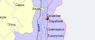
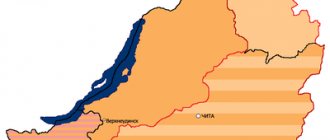
Districts of the Astrakhan region on the map
Of the 11 districts of the Astrakhan region, only 4 have district centers in cities:
- Akhtyubinsk;
- Kamyzyak;
- Narimanov;
- Kharabali.
You can see the territorial division of the region on the map of the Astrakhan region by district.
- The Kharabalinsky district is located in a semi-desert zone. In the 13th-14th centuries. The city of Sarai-Batu, the capital of the Tatar-Mongol Khanate, was located on the territory of the region. In the Soviet Union, the Kharabalinsky district had no administrative significance; it was abolished and assigned to the Lower Volga Territory. Today the district consists of 1 city and 9 villages.
- The Akhtyubinsky district on the map of the Astrakhan region is located in the northeast and stretches along the left bank of the Volga. The administrative center of the district is the city of Akhtyubinsk, which includes 15 municipalities. The region is inhabited by more than 70 thousand people, most of whom are employed in the agricultural sector.
- The Kamyzyak region is located in the Caspian lowland and is washed by the waters of the Caspian Sea on the southern side. This is one of 3 large industrial areas, the scale of which in relation to other territories can be assessed on the map of the Astrakhan region with villages. There are 35 industrial and 14 agricultural enterprises operating in the district. Fishing and tourism are well developed in the area. The administrative center is the city of Kamyzyak, inhabited by more than 40 thousand people.
- Narimanovsky district occupies the southwestern part of the Astrakhan region. The main industrial enterprise in the area is shipbuilding. The region is inhabited in almost equal numbers by Russians, Tatars and Kazakhs.
The road map of the Astrakhan region shows all possible routes of communication between the regions of the region. Also, the international highway E40 and the federal highways M6 and M8 pass through the region's districts. For tourists who travel to the shores of the Caspian Sea by car, such a detailed map of the Astrakhan region will be an indispensable assistant on the way.
Education. Cultural institutions
In A. o. There are 305 preschool institutions, 382 general education institutions, 31 primary and 42 secondary vocational institutions. educational institutions, 79 additional institutions. children's education (2005). There are 41 universities (including branches and representative offices), including 13 state ones: Med. Academy (since 1918), Technical. University (founded in 1930 as the Astrakhan Institute of Fishing Industry and Fisheries, since 1994 its current name), Ped. University (since 1932), Conservatory (1969), etc. 301 libraries. Museums: in Astrakhan - Astrakhan United Historical and Architectural Committee. museum-reserve (founded in 1837), Art Gallery named after. B. M. Kustodiev (1918), Museum of Military Glory (1975), house-museums of B. M. Kustodiev, V. Khlebnikov, S. M. Kirov, Museum of Culture of Astrakhan (in 1978–2001 Literary Museum of N. G. Chernyshevsky ). Also historical and local history museums in Black Yar, Krasny Yar, the village of Liman; in the village Altynzhar – Museum with a mausoleum (1996) of Kurmangazy Sagyrbaev.
Architecture and fine arts
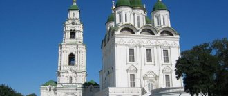
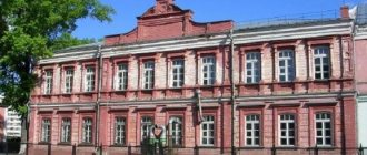
Astrakhan Kremlin. Archive of the "Orthodox Encyclopedia"
To the oldest architects. monuments on the territory of A. o. include: the ensemble of the Astrakhan Kremlin (late 16th–18th centuries), the Demidovsky courtyard (17th–18th centuries) in Astrakhan, Petropavlovskaya Ts. in Black Yar (late 17th – early 18th centuries) with a cast-iron floor and paintings. Fragments of the Enotaevskaya fortress have been preserved - an example of regular fortress construction of the 18th century. The Vysokogorskaya Assumption-Nikolaevskaya Churkinsky hermitage is being restored (founded in the 17th century; cell buildings and other buildings were built in the 19th – early 20th centuries). In memory of the Kalmyks - participants of the Fatherland. During the war of 1812, a Buddhist stone Khosheutov temple-khurul was built (now in the village of Rechnoye; 1814–1817, according to the design of Batur-Ubashi Tyumen, consultant monk Gavan Tshombe), the composition of which was based on the plan of St. Petersburg. Kazan Cathedral. Buildings in the style of classicism: ensemble center. Black Yar Square with a cathedral completed by a rotunda (1830s), Trinity Cathedral in Enotaevka (1832–36, architect I. I. Charlemagne), Guardhouse in Astrakhan (1807), etc. The Churches of the Intercession were built in the neo-Russian style in With. Knocked in the village. Salty Zaimishche (1906), Uspenskaya Ts. in the village Kopanovka, c. Nativity of the Virgin Mary in Nikolskoye (1912). During the construction of trees. Churches traditionally used the “octagonal on quadrangular” type (church in the village of Vladimirovka, 2nd half of the 19th century, etc.). The complex of trees was built in Art Nouveau style. buildings of the Tinaki resort (1910s), also the Azov-Don Bank in Astrakhan (1910, architect F.I. Lidval). Contemporary professional art A. o. represented by painting (S. G. Dyakov, Yu. A. Lebedev, F. N. Milokhin, M. A. and S. A. Prikazchikovs, K. K. Safargaleev, K. A. Titov, A. N. Turkin) and graphics (N.K. Rudikov, A.M. Shaposhnikov).
Cities and villages of the Astrakhan region on the map
Astrakhan has an “air gate”. Astrakhan International Airport receives flights from all over Russia and abroad. On the map of the Astrakhan region with cities and villages you can see that the Airport is located in the suburbs of Astrakhan.
There is also a railway station in Astrakhan, which welcomes guests and residents of the city or takes them on a journey through the central, eastern and southern parts of the country. On the map of the Astrakhan region you can see in detail the direction of the railway tracks.
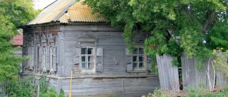
There are many small settlements and large villages located in the region. The desert and semi-desert plains of the region are used largely as pastures for livestock. In addition to farming and cattle breeding, the population of the region is actively developing fishing.
National traditions are being developed and carefully preserved in the Astrakhan region. The second largest people in the region are the Kazakhs, who have cultural centers in villages and cities, and the national language is taught in schools. A map of the Astrakhan region with cities in good quality allows you to see the locations of Kazakh cultural centers, as well as Orthodox churches, many of which were built more than a century ago.
Music
In music culture of A. o. the oral traditions of Russians (including Cossacks), Kalmyks, and Tatars are united. The first records of Russian folklore was carried out by M. A. Balakirev. Among the folklorists are M. L. Trituz, M. N. Nigmedzyanov, A. S. Yareshko, K. V. Guzenko, E. M. Shishkina, M. G. Khrushcheva, A. R. Usmanova. Among Prof. composers - A. I. Blinov, Yu. P. Gontsov, A. V. Ryndin. The first professional performing group - founded in the beginning. 17th century Astrakhan Bishop's Choir (V.K. Trediakovsky was a singer in it).
Formation of prof. music culture began in late 19th century with the opening of a music school and a branch of the Russian Musical Society in Astrakhan. In the 1920s–40s. There were several muses in Astrakhan. and opera houses, including the Theater of Music. comedy (1945–48). In Astrakhan they work: State. music theater (since 1995), State. Philharmonic Society (since 1944), State. cons. (since 1969), regional branch of the Investigative Committee of Russia (since 1992). Nar. music performed by prof. concert groups “Astrakhan Song” (since 1978), Russian ensemble. adv. instruments "Skif" (1992), song and dance ensemble of Caspian fishermen "Moryana" (1945–90), etc. The International festival of vocal art named after. V.V. Barsova and M.P. Maksakova (since 1987).