The Kemerovo region has been inhabited by people since the Middle Paleolithic. Ancient sites found by archaeologists prove a rich historical and cultural layer.
The Kemerovo region appeared as an administrative unit in 1943. This is one of the largest regions of Western Siberia.
The region is also called Kuzbass - this is where the largest coal basin, Kuznetsk, is located. The mineral was first discovered in 1721 by ore miner from the Kuznetsk fort Mikhailo Volkov.
Currently, the Kemerovo region is a large industrial center supplying the country with coal and metal. The tourist attractiveness of the region is due to the cultural heritage of the small indigenous peoples of Siberia, nature, and archaeological finds.
For ease of route planning, we have marked all mentioned cities and attractions on the map of the region:
Tomsk writing
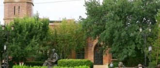
A unique museum-reserve is located on the banks of the Tom - this is the Tomsk Pisanitsa. Its uniqueness lies in the fact that ancient people lived here and left evidence of their existence in the form of rock paintings.
More than 280 drawings dating back to 3000-4000 BC. The images of the sun, moose, bears, birds and even boats are well preserved. Some drawings depict the life of the people who lived here then.
In this reserve, the life of the indigenous inhabitants of the region - the Shors - is studied. A whole complex has been created telling about the life and everyday life of these people. They didn’t forget about the nomadic Mongols - a “Mongolian yurt” was erected. In the 17th century, the Slavs appeared in the region, and tourists can get acquainted with their way of life.
The nature here is incredibly beautiful, which you can admire from observation platforms and while walking. The unique virgin nature attracts tourists here, for whom special routes have been created, one of which leads to the Itkarinsky waterfall.
TOP-3 – beautiful places in the Kemerovo region
Most of the most striking sights of the Kemerovo region are among the so-called “seven wonders of Kuzbass”.
Reserve "Kuznetsky Alatau"
- Coordinates on the map: 54.365000, 88.119722.
In the vicinity of Novokuznetsk there is the only nature reserve in the region. The reserve was founded in 1989 on an area of over 400,000 hectares. The main goal of its creation is to preserve the unique biodiversity of the Kuznetsk Alatau mountains. Alatau covers sections of the Novokuznetsk, Mezhdurechensky and Tisulsky districts.
The reserve's lands include part of the Stanovoy Range, the valley of the Rastai River, glaciers, and many picturesque swamps and lakes.
You can visit the beauty of Kuznetsk only with the permission of the reserve administration. Passes and excursions must be agreed upon in advance. There are several trails for hiking, river rafting, fishing and snowmobiling. The reserve also has a museum, an eco-center, a rehabilitation center for injured birds, and horse rentals.
Shorsky National Park
- GPS coordinates: 52.772964, 87.926010.
The south of the region is occupied by a stunningly beautiful mountainous region, nicknamed Siberian Switzerland. Like the Swiss Alps, Mountain Shoria attracts many athletes, professionals and amateurs.
Local ski resorts are in demand among tourists from all over Russia. In addition to recreational resources, the peaks provide people with rich mineral reserves. So, for more than 150 years, since the mid-19th century, iron mining has been carried out here.
In the same year, a vast national park with an area of more than 410,000 hectares was created in the Gornaya Shoria reserve. “Shorsky” is entirely located on the territory of the Tashtagol region and includes five forest districts.
Within the boundaries of the park there are dozens of attractive attractions: rock outcrops, caves, waterfalls, and an ethnographic museum. More than 500 species of plants grow in Shorsky, including such rare specimens as Rhodiola rosea and Siberian kandyk, 62 species of mammals and 180 species of birds live.
Ecological routes of varying degrees of difficulty have been developed for tourists. There are three cordons on the border of the park, with guest houses built next to each.
Lake Big Berchikul
- Coordinates: 55.611043, 88.343891.
Near the village of Tisul there is a vast freshwater lake, the largest in the entire region. The name of the reservoir is translated from ancient Turkic as “wolf lake”. Not only the reservoir is beautiful, but also its surroundings: on the banks of Big Berchikul there are light coniferous forests, forest-steppes and mountain taiga, in which a dozen rare plants listed in the Red Book grow.
The lake has no drainage; only a small channel connects it with the Dudet River. Not a single major river flows into Berchikul. Despite this feature, the reservoir does not change in size even in the summer heat, when the water actively evaporates and many other lakes simply dry up.
The huge bowl of this Kuzbass landmark is filled with underground springs and small streams all year round. There is a tourist base near the lake; vacationers can enjoy fishing and horseback riding. Berchikul is rich in fish; it is home to carp, pike, perch, tench, bream, silver carp and many other species.
Itkarinsky waterfall
Itkarinsky waterfall - its waters cascade from one ledge of the bank of the Tom River. The water can be drunk without fear; doctors consider it mineral water, table water.
The waterfall is surrounded by a mixed forest. The guide will tell you an interesting legend about the people who previously lived on the edge of the forest where the waterfall ledge is located. There is also a parking lot for tourists.
Tutal Rocks
Fans of mountaineering and mountain tourism will certainly be interested in the Tutal Rocks. They were formed as a result of the washing out of shale rocks by the waters of the Tom River. Depending on the distance from the railway, tourists call them near and far. These picturesque rocks are loved by rock climbing enthusiasts. Here, tourist clubs conduct training sessions with mountaineering enthusiasts.
Linden Island
3 km from the village of Kuzedeevo, Novokuznetsk district, there is an unusual natural monument - Linden Island. It was discovered by the Russian scientist P. N. Krylov in 1889. The age of this extraordinary island, according to scientists, is several million years. The area of the relic grove is 110 square meters. km. The trees are in a special microclimate, here the temperature is 2-3 degrees higher than usual.
After the Ice Age, Southern Kuzbass is characterized by fir-cedar forests, and here broad-leaved linden trees grow. Scientists explain this phenomenon by the fact that the glacier did not touch this territory and the linden trees survived. When the glacier retreated, a linden island was formed, the territory of which in 1964 received the status of a natural monument.
Caves and quarries of the Kemerovo region
On the territory of Kuzbass there are many caves, quarries and mines created by people or nature itself.
Azas cave
- Coordinates: 52.765790, 88.497888.
One of the most visited attractions in the national park is a huge cave. The total length of all tunnels is 120 meters. Travelers are interested not only in the beauty and size of the cave, but also in the legends associated with it.
There are rumors that a yeti, or Bigfoot, lives in the area, so paranormal hunters often meet near the natural monument.
Great Kizas Cave
- Coordinates: 52.642450, 88.683452.
Another less known, but no less interesting cave can be found on the banks of the Mras-Su River near the mouth of the Kizas River. The attraction is located on a hill; to get to it, you need to walk along a dangerous steep path.
The entrance to the tunnel is hidden among limestone blocks. The cave consists of two tiers with a total length of more than 200 meters. It is very cold and humid inside in any weather. The distant halls are decorated with small ice stalagmites and beautiful stains on the walls.
Gavrilovskie caves
- Coordinates: 54.257814, 85.858618.
The most famous caves in the Guryevsky region are located above the Bolshaya Tolmovaya River, 2 km from the village of Gavrilovka. The two caves are located a short distance from each other in rocks composed of crystalline limestone. The entrances are located near the river and are wide crevices in the rocks.
Gavrilovskaya-1 goes 15 meters deep into the mountain, the length of the tunnel is about 250 meters. The dimensions of the Gavrilovskaya-2 cave are not precisely known. It’s cold inside the caves even in summer; the floor is in some places littered with boulders and wet red clay, which makes it difficult to move inside the passage.
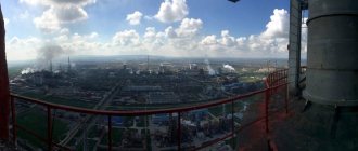
Kuzbass open-pit mines
The Kuznetsk coal basin is one of the richest coal deposits on the planet. Solid fuel mining has been carried out in the region since 1721. Coal is both a gift and a curse for the Kemerovo region.
On one side of the scale is a mineral resource that provides heat, on the other is irreparable harm to the environment and the tragedy in the mines that claimed the lives of hundreds of people. Coal mines of amazing size have become not only the main economic resource of the region, but also its colorful attraction.
Pine with rings - a botanical natural monument
In the Promyshlennovsky forestry enterprise you can see an extraordinary pine tree, which has become a botanical monument of nature. This tree attracts nature lovers with its unusual appearance. At a height of 16 meters there are unusual rings on the trunk. The tree is about 60 years old, quite healthy and without signs of pine tuberculate cancer.
Scientists suggest that while still a seedling, the pine tree suffered a tumor-like bacteriosis and, as a result, growths formed on the trunk, which are a very valuable and expensive material from which various kinds of crafts, boxes, smoking pipes, hairpins and other souvenirs are made. These products have an unusual texture.
Royal Gate
Ten kilometers from the village of Ust-Anzas, along the Mras-Su River, travelers are offered an amazing, beautiful view, which is the decoration of Mountain Shoria - the Royal Gates.
This Siberian corner attracts extreme sports enthusiasts, where they can enjoy skiing. Mountain Shoria in winter serves as a ski resort for all Siberians.
In these picturesque places there are sheer hundred-meter cliffs. These amazing rocks change color depending on the weather. On a bright sunny day they look pink, and on a cloudy day they look gray.
Rock paintings are visible on the inaccessible rock. In the rock itself, time and water have formed a hole that resembles a drop. And, of course, there will be someone who will tell vacationers another legend about the Royal Gates, with which the Siberian land is rich. In fact, the Royal Gate received its name, presumably, from its similarity to the Royal Gate in the Orthodox iconostasis.
The most interesting mountains of Kuzbass
The Kemerovo Mountains are a truly magical place that annually attracts hundreds of climbers, skiers, speleologists and archaeologists.
Salair Ridge
- Coordinates: 54.089722, 85.827778.
The southern part of the region is covered with mountain ranges. One of the most majestic and beautiful is the Salair Ridge. In addition to the Kemerovo region, the 300-kilometer ridge occupies the territories of the Novosibirsk region and the Altai Territory.
The peaks of Salair are relatively low, the height of the largest of them, Mount Kivda, barely exceeds 620 m. A significant part is ordinary hills. The relief of the ridge is varied; there are dozens of karst sinkholes, caves and other formations.
Celestial Teeth
- Coordinates: 54.133333, 88.750000.
To the south of the Kuznetsky Alatau nature reserve there is one of the most picturesque areas not only in the region, but throughout Russia. In an area of about 90 kilometers, the peaks of several mountain ranges converge, primarily the Tiger-Tysh ridge.
The delightful area received the sublime name “Celestial Teeth”. The region is popular with tourists, and there are hotels and guesthouses in the surrounding area.
Most travelers prefer wild routes; during hikes, adventurers can admire mountain slopes covered with taiga and tundra, snow-capped peaks, unusual rocks, the beautiful valley of the Tom River and spectacular waterfalls.
Mount Green
- Coordinates: 52.948556, 87.928537.
The mountain slopes near the village of Sheregesh have been attracting athletes from different regions of the country for more than 40 years. In 1981, shortly before the Spartakiad, a ski resort was opened on Mount Zelenaya.
Today, at the top there are already 15 trails of varying degrees of difficulty, 19 ski lifts, and at the foot there are hotels, cafes, shops and other institutions necessary for a comfortable stay. The Russian Alpine Skiing and Snowboarding Championships and other competitions are regularly held on Zelyonaya.
Tutal Rocks
- Coordinates: 55.708333, 85.006111.
In the Yashkinsky district, the bank of the beautiful Tom River is decorated with high cliffs. A powerful river flow has eroded rocks for centuries, forming wonderful sculptures. Rocks are divided into several groups depending on their location. The stone ridge attracts both climbers and archeology lovers.
Professional climbers from all over Western Siberia regularly hold mass training camps and training sessions at this natural training ground. The rocks are also interesting from a historical point of view: on the steep walls there are images of animals left by the hands of ancient people. Tutal petroglyphs date back to the Neolithic era.
Royal Gate
- Coordinates: 53.050987, 88.415012.
One of the main symbols of Mountain Shoria is the magnificent rocks that resemble a huge arch. The landmark is located a few kilometers from the village of Ust-Anzas on the banks of the Mras-Su River.
The height of the stone gate is 100 meters. Their color depends on the lighting; in sunny weather, the gloomy steep walls appear pink. Extreme sports enthusiasts who climb the rocks can discern the drawings of ancient people on them.
Museum of Ethnography and Nature of Mountain Shoria
In the small town of the Kemerovo region, Tashtagol, there is a museum of life and nature in the southern region of Western Siberia - Mountain Shoria. It was created in 1987. One of the museum halls is equipped for exhibitions. There is a hall where the visitor can get acquainted with the life and material values of the indigenous people of this region - the Shors.
The nature of the region - the Shor taiga - is well shown. The guide will introduce you to the history of the development of the gold mining and mining industries.
Address: Tashtagol city, 8th March street - 4.
Celestial Teeth
Celestial Teeth (Tiger-Tysh) is one of the most beautiful mountain regions of Kuzbass, located 60 km east of the city of Mezhdurechensk. The highest peak is Verkhniy Zub (2,178 m above sea level). Located on the border of the Kemerovo region and Khakassia near the Luzhba railway station. Here you will find extraordinary beauty of nature and crystal clear air. Celestial teeth attract tourists making winter and summer hikes from all over the Kemerovo region. Many clear streams and rivers flow along the slopes of blue tarn lakes. And of course, the local aquatic fauna will not leave indifferent any person who decides to go fishing among the majestic mountain landscapes. Taimen, perch, pike, Siberian grayling - you can catch all this in the lakes and rivers of the south of the Kemerovo region.
Worship Cross
An Orthodox cross is often placed at crossroads so that a traveler can pray on a long journey. This cross is called the “Worship Cross”.
In Gornaya Shoria on Mount Kurgan at an altitude of 1555 meters , a Worship Cross was erected for the 2000th anniversary of the Birth of Christ. Together with the base (5 meters), this structure has a height of 20 meters and weighs 7.5 tons.
Mountain Shoria is a well-equipped ski resort, here you can ski, relax comfortably and see natural monuments. Vacationers have the opportunity to visit the Poklonnaya Cross by riding a snowmobile for about 20 minutes. Physically fit tourists can get to the Cross on foot along two trails. The Worship Cross attracts thousands of pilgrims every year.
Parks, entertainment and more
Ski resort "Sheregesh"
Address: pos. Sheregesh, st. Turistskaya (Green Mountain) Website: https://www.sheregesh.su Phone: +7 933 300‑50-00, +7 3843 33‑93-33 Opening hours: 09:00-17:00
The popular ski resort in Russia Sheregesh has 15 slopes. Their length is from 700 to 5000 meters, and the elevation changes are from 120 to 630 meters.
There are several hotels and guest cottages, equipment rental, and a cafe on the territory of the complex.
On the resort's website you can find travel companions, order a transfer, and book accommodation.
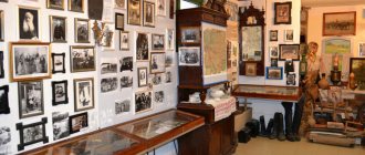
Cholkoy Museum
Siberians tirelessly study the life of the peoples who inhabited these lands before the arrival of the Slavs. In the city of Belovo, Kemerovo region, you can visit the Cholkoy Museum.
There are always a lot of people here: tourists are interested in the life, traditions and way of life of the peoples who lived here previously. The museum has a lot of exhibits that introduce visitors to the life and way of life of the small peoples of Siberia. The guides will show you household items, labor items, furniture, dishes and tell you about the customs of this region.
Address: Belovo, Tsentralnaya street-6.
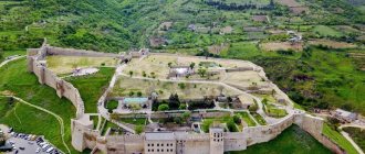
Kuznetsk Fortress
The Kuznetsk fortress, which is located in the Novokuznetsk region, was recognized as the main symbol of the city in 2008.
Emperor Paul I gave an order to build a fortress in this place, which was supposed to protect Southern Siberia from the Chinese invasion. In 1820 the fortress was built. The construction of this military structure took more than 20 years. Fortunately, she has never had to participate in wars throughout her existence. As a result, in 1846 the fortress lost its military significance.
Now there is a museum here. The museum was opened in 1991 and has an area of almost 21 hectares. On its territory there are other historical and natural monuments, including a waterfall. Museum employees protect and study archaeological monuments and archival documents. The museum's exhibitions are updated periodically.
Various military-patriotic events are held here. There is a permanent exhibition of gold and silver items.
Address: Novokuznetsk city, Krepostnoy proezd-1.
Churches, cathedrals and temples
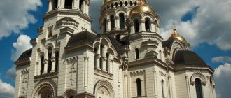
Holy spring in the village of Gavrilovka
Location: village. Gavrilovka Nearest town: Salair
For a long time, the source was just a spring to which a path was trodden. In 1995, the spring was consecrated, after which its arrangement began.
Now this place is a complex of a small chapel, a dressing room and a soup kitchen.
It is believed that the spring appeared after priests and parishioners were shot at this place during the Civil War. They were taken out of the church right during the liturgy.
Coal Museum
In Kemerovo on the street. Rukavishnikov there is a unique, the only Coal Museum in Russia, created in 1999.
It is in Kemerovo that the main coal mining takes place. Here is the largest development of industrial production of black gold in the entire Kuzbass, which is constantly growing.
The museum presents a unique collection of mined coal, all its diversity. Museum guides will introduce visitors to the history of coal mining. Here they will talk about the hard and dangerous work of miners.
A tourist can expand his knowledge of modern technology for the extraction and processing of raw materials. Museum workers carry out various types of research, environmental and educational work, as well as career guidance for young people aimed at working as miners.
Address: Kemerovo, Rukavishnikova street-21.
Red hill
In 1991, the open-air museum “Krasnaya Gorka” was created in Kemerovo on the territory of a spent coal mine.
On the banks of the Tom River there is a mining complex preserved in its natural form. This complex unites different stages of development of industrial Kuzbass.
Here is Gorelaya Mountain, where coal was found in 1721. One of the adits has been preserved, as well as civil structures and residential buildings that were built during the period of activity of the Kuzbass AIK.
AIK is an autonomous industrial colony of foreign workers, which from 1921 to 1926 participated in the development of heavy industry in the Kuznetsk coal basin. Workers of 30 nationalities helped the Soviet government raise this region.
In 2003, a sculpture of a Kuzbass miner created by Ernst Neizvestny was installed in the museum. In addition to viewing the museum's exhibits, visitors can get acquainted with the history of the mine through newsreels by visiting the museum cinema.
Address: Krasnaya Gorka street-17.
Historical places
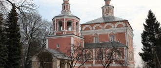
Tomsk writing
Where is it located: village. Written Website: https://gukmztp.ru Phone: +7 3842 75‑10-90
In the Lower Tomsk region, a group of rocks stretches for 50 kilometers, becoming famous thanks to the petroglyphs found.
The rocks are covered with ancient drawings and inscriptions from the Bronze and Early Iron Ages. In total, 280 samples of rock art were discovered.
Museum of Ethnography and Nature of Mountain Shoria
Address: Tashtagol, st. 8 March, 4 Phone: +7 38473 3‑20-19 Website: https://www.shor-museum.ru Opening hours: 09:00-18:00 Tue-Sun
The museum appeared in the early 90s to study and preserve the traditions and language of the Shor people. To replenish the fund, museum staff conducted ethnographic expeditions throughout the Kemerovo region and Khakassia for several years.
Among the exhibits of the museum there are rare samples: the alphabet of 1906 for Shor children, a collection of ancient icons, household items of the Siberian hermit A.K. Lykova.
Cholkoy Museum
Address: s. Bekovo, st. Central, 6 Phone: +7 38452 5‑92-81, +7 38452 5‑92-73 Website: https://cholkoi.ru Opening hours: Mon-Fri 10:00-18:00
This is a historical and ethnographic museum dedicated to the Altai-Siberian Teleut people.
Some of the museum's exhibits are located in the open air: a fort, a yurt, altars. Objects telling about the Teleuts before and after the arrival of Russian settlers to these lands are kept in closed rooms.
Most of the exhibits, for example, elements of traditional clothing, were brought by residents of the region belonging to the Teleuts. In the museum, visitors will learn not only historical facts from the life of this people, but will also hear legends about the Master of Altai, his daughters and the origins of people.
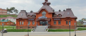
Museum-Reserve "Historical Mariinsk"
Address: Mariinsk, st. Lenina, 10 Phone: +7 38443 5‑20-19, +7 38443 5‑27-54 Website: https://mariinsk-museum.ru Opening hours: 10.00-19.00
The museum represents the ancient part of the city of Mariinsk - 73 wooden and stone houses built in the 19th century.
Here you can get acquainted with the life of a merchant, visit the house of the writer Chivilikhin, visit the birch bark museum and learn the birch bark craft.
The museum constantly hosts historical and city festivals, master classes, and children's events.
Ethnographic Museum "Tazgol"
Coordinates: 53.051094, 88.415074 How to get there: 100 km from Tashtagol to the village. Ust-Anzas
The museum was created on the basis of the village of Ust-Anzas, an ancient settlement site of the mountain Shors. Medieval buildings, two-hundred-year-old manors and gold mines have been reconstructed here.
“Tazgol” is intended to tell about different periods of the mountain Shors from primitive to present times.
Local residents still lead a measured lifestyle, engaged in fishing, hunting, blacksmithing, and gold panning.
Worship Cross on Mount Kurgan
Location: village. Sheregesh How to get there: from Kemerovo, Novokuznetsk or Tashtagol by bus or train, travel time - 7 hours
Placing worship crosses on high places is a long-standing tradition of Orthodox Christians. There is a 15-meter cross on Mount Kurgan, which is visible from many points.
The weight of the structure is more than 7 tons, so it was delivered to the mountain by helicopter.
Tomsk Pisanitsa Museum-Reserve
Address: pos. Written Website: https://gukmztp.ru/ Phone: 8-3842-75-86-33 Opening hours: 10:00-18:00 Wed-Sun (winter period); 10:00-18:00 Mon-Fri, 10:00-19:00 Sat, Sun (summer period) Cost: 200-250 rubles - adults, 150 rubles - children
At the beginning of the 17th century, drawings and inscriptions of primitive people were discovered on the rocky banks of the Tom River. This find became the basis for the creation of the museum.
The most valuable exhibit of the museum is nature. Thanks to the creation of the reserve, it was possible to preserve rare species of trees, shrubs, and grasses. Some of them survived the Ice Age and are listed in the Red Book. Scientists have the opportunity to observe wild animals in their natural habitat.
The museum-reserve has an “Adopt a Pet” program. You can choose any animal from the reserve and become its guardian. Funds from guardianship are used to improve the living conditions of animals.
Dostoevsky Museum
In Novokuznetsk there is a museum of F.M. Dostoevsky. It was opened in the spring of 1980.
The writer’s first wife, Maria Isaeva, lived in this house from 1855 to 1857. Here they got married on February 6, 1857. Museum workers will tell visitors about the writer’s first love and how it influenced his work.
The museum has created a unique exhibition occupying five halls: “Road”, “Kuznetsky Piglet”, “Mrs. Moskaleva’s Salon”, “Triangle”, “Wedding”. Having visited these halls, museum guests will better understand the philosophy and symbolism of the writer’s works.
The furnishings in the house were recreated using archival materials. All the items in the museum are original, many books were donated by the writer’s descendants, there are many works of applied art, photographs and posters. The library contains about 24 thousand volumes .
After leaving the museum, you can continue the tour of the places described by Dostoevsky in Crime and Punishment. The classic of Russian literature stayed in Novokuznetsk for 22 days.
Address: Novokuznetsk city, Dostoevsky street-29.
Drama Theater of Novokuznetsk
The Drama Theater of Novokuznetsk was created in 1931. The troupe consisted of 60 people and the symphony orchestra - 15 musicians. Due to the fact that the old building was destroyed by fire, a new one with 1,200 seats . The first performance of the theater was “Intervention” by L. Slavin.
During the Second World War, the theater gave up its stage to evacuated theaters from Moscow, Ukraine and other Russian cities, and it began staging its own performances in Leninsk-Kuznetsky.
In 1963, a new building in the imperial classical style was built in Novokuznetsk. The theater is very popular not only in the Kemerovo region, but also often tours various cities of Russia and former Soviet republics.
Address: Metallurgists Avenue - 28.
Lakes to visit in the Kemerovo region
The most popular tourist routes in the Kemerovo region pass by beautiful reservoirs with clean water and an abundance of fish.
Lake Tanay
- Address: s. Zhuravlevo, Promyshlennovsky district.
The amazing Lake Tanai lies on the border with the Novosibirsk region. Its length is 5 kilometers, width is less than 3 kilometers. The lake is quite shallow, although there are dips up to 4 meters deep. The reservoir is surrounded on all sides by mountains and steppes.
Floating islands of different sizes move along the water surface. People have settled on the banks of the Tanai since the Stone Age; archaeologists are finding more and more traces of ancient inhabitants in the surrounding area. Today, various festivals and celebrations take place here.
Belovskoye Reservoir
- Coordinates: 54.424582, 86.462406.
A large reservoir was created in 1964 in the upper reaches of the Inya River. The length of the reservoir is about 10 kilometers, the width is more than 2 kilometers, the maximum depth reaches 12 meters. Kemerovo residents call the artificial reservoir the sea.
There are a number of cozy beaches on the shores, the most popular of which are “Golden Sands” and “Belovsky”. Local residents love to spend warm summer days on the lake; there are all conditions for swimming, picnicking, fishing, water skiing and other leisure activities.
Lake Srednetersinskoye
- Coordinates: 54.386939, 88.359351.
Among the treasures of Kuznetsk Alatau, a special place is occupied by the picturesque Srednetersinskoye Lake - the deepest body of natural origin in the Kemerovo region. Its maximum depth reaches an astonishing 60 meters. The Srednyaya Ters River originates from the reservoir.
Rybnoye Lake
- Coordinates: 54.329709, 88.403153.
Within the boundaries of the Kuznetsky Alatau Nature Reserve lies another water record holder of the region - the largest mountain-glacial lake. The reservoir is unique in its kind, although it is small in comparison with other lakes in the region: its length is only 1 kilometer and its width is 500 meters.
The reservoir was nicknamed Fishy for the abundance of fish, in particular lake grayling. The beautiful Upper Ters River flows out of the lake.
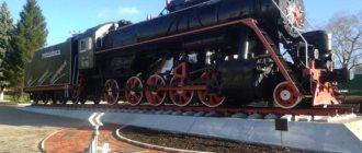
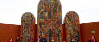
Memorial Museum of Military and Labor Glory of Kuznetsk Metallurgists (Novokuznetsk)
Metallurgists of Kuzbass made an invaluable contribution to the victory in the Second World War. In memory of their feat, a memorial museum was opened on Victory Day in 1985, in which the names of all Kuzbass metallurgists who gave their lives during the Second World War are engraved on memorial plates.
The Eternal Flame also burns here, lit from the open-hearth furnace that produced the first steel for armor in 1941.
The museum has collected more than 2,500 exhibits telling about the life and struggle of metallurgists. Excursions here are conducted with musical accompaniment; the original voice of Levitan sounds, announcing the beginning of the war and Victory. This evokes deeper emotional feelings about wartime.
Address: Pobedy Square - 1/1.