At the beginning of May, a draft of a new general plan for Kursk was published by the Giprogor Institute of Urban Planning and Investment Development, designed for implementation until 2040. It was presented to Governor Roman Starovoit on May 25: project manager Olga Enina and chief architect of the project Irina Ratnikova spoke at the event.
“We agreed that we will prepare for the 1000th anniversary of Kursk. As part of this work, we held an architectural competition to develop an architectural concept for the renovation of the historical city center. And before starting the engineering design of these objects, it is necessary to develop and approve urban planning documentation, which, of course, is the urban planning plan of Kursk,” noted Roman Starovoyt.
The project caused controversy among the townspeople, and one of the most problematic issues was the planned road through the dachas and pine forest in the KZTZ area. Due to social tension (or other reasons), public hearings scheduled for the end of May were postponed for a month. As the head of the region reported, during this time the developers must take into account a number of comments. It has not yet been clarified what kind of comments we are talking about.
Everyone was asked to send their comments to the Committee of Architecture and Urban Planning of Kursk: to do this, you need to come to Lenin Street, 69 before June 11 or send them by email
At the same time, Kursk social activists Vladimir Sinelnikov and Oleg Pogozhikh from the Public Control Inspectorate announced their readiness to hold their discussion: last time such an event was dedicated to the fate of the tram. They promise to announce the exact date and time in the coming days.
General plan is a document that sets out the planned state and purpose of the territories of a municipality. It approves the boundaries of the settlement, functional zones and the layout of local facilities.
It is important to highlight two points. Firstly, there are no sanctions in the legislation for failure to implement the intentions laid down in the general plan, so some infrastructure projects may not come to fruition, remaining “on paper”. Secondly, functional zoning in the general plan does not impose requirements and restrictions on land plots, but prepares the ground for the development of an urban zoning map into land use and development rules and urban planning regulations.
Suitable for a rural lifestyle rather than an urban one
At the presentation of the project, Olga Enina thanked the officials for the carte blanche given, noting the lack of pressure and the opportunity to express the institute’s point of view on the city’s development option.
Studying the current state of Kursk, the developers noted the significant extent of the city from north to south and the predominance of individual buildings, “more suitable for a rural lifestyle than for an urban one.” Later, Roman Starovoyt agreed with the observation.
According to Giprogor, due to the shortage of free territories, Kursk is gravitating towards extensive development of the city with the expansion of its borders, and the spotty nature of development only aggravates the situation. The historical appearance, which needs careful attention, “has suffered from chaotic estate development.”
In addition to the historical center, additional points of attraction and public spaces have not been formed in Kursk; there is also an imbalance in the provision of green spaces to different areas.
In response to this, the developers proposed a focus on more compact development within the city and strengthening connections between existing territories. The concept of the general plan, according to Giprogor employees, was based on the development of Kursk without changing the current city boundaries. In the central part of the city, it is planned to increase the density of low- and mid-rise residential buildings in accordance with the previously developed strategy for the socio-economic development of the city.
It was noted that the provision of green spaces to city residents is now four times less than the standard: only 4.2 square meters. m per person with the required 16. To solve this problem, it is proposed to create a system of green spaces, including in residential areas of the city, and implement the concept of a “park city”.
But for the most part, they plan to achieve the goal by including urban forests in the zone of “green spaces” for recreational purposes - including 9 hectares in the area of Entuziastov Avenue and 27 hectares in the Log-3 tract. In order not to formally reduce the number of urban forests, they plan to include the lands of the Krutoy Log tract and areas of environmental significance.
Map of Kursk with houses. Features of architecture and attractions of the city
On the territory of Kursk there are unique buildings dating back to the architecture of the 19th century. History buffs will find many interesting places in the city. Using Kursk routes on the map, you can plan a walk around the city to see all the sights:
- Excellent examples of ancient architecture are the building of the former Assembly of the Nobility, the estate of the merchant Khloponin, and the Treasury House.
- While walking around the city, it is worth visiting the numerous museums. This is a museum of archaeology, local history, literature, zoology, as well as a museum of automobile transport and even a tram.
- On the territory of the city, using a map of Kursk with streets in good quality, you can find the famous Church of the Dormition of the Mother of God and the Great Martyr Nikita.
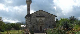
- The Catholic Church of the Assumption of the Virgin Mary is worth a visit. It was erected in the 19th century. The building was made in the neo-Gothic style.
- There are many theaters in the city. A map of Kursk with streets and houses will help you find the famous puppet theater.
- Lovers of fine art can visit the art gallery. On its territory there are more than eight thousand works of art dating back to the 16th-20th centuries. Also in the museum's collections are a variety of paintings, sculptures, as well as folk and applied arts. A map of Kursk with house numbers will help you find the gallery.
- The Arc de Triomphe is considered an interesting landmark. This complex can be found on Pobedy Avenue. The arch rises to a height of 24 meters. On the adjacent alley there are various types of military equipment.
Road through the forest and SNT
The moment that caused the greatest public outcry was the construction of a highway connecting Plevitskaya Avenue and the Volokno microdistrict. According to the project, it should pass through the forest in the KZTZ microdistrict. The developers explained what they proceeded from when designing the road:
“It was proposed to extend Nadezhda Plevitskaya Avenue to the southern part of the city and connect it with Leninsky Komsomol Avenue. We worked on the routing of this project of citywide importance, because now the city rests on one link, Engels Street. You yourself know that there are traffic jams there during rush hours: for such a city we need a backup. We laid this route where there is a power line route, and there are clearings in the urban forests.”
Based on the explanations of Giprogor employees, deforestation in this area will be minimized, since the road will pass along an already existing clearing.
Despite this, a significant part of Kursk residents are against the new highway: people fear that the highway will destroy the existing ecosystem, deprive them of a place for walking and recreation, and that the forests will be given over to residential development in the future. Those who support the construction of the route note that the problem of connecting different areas has been brewing for a long time, and there are no other options for solving it.
“Somewhere they publish that this is an already approved general plan, that the forest will be cut down. You know my position: I will personally fight for every tree and stand guard around the clock. All sorts of speculations are absolutely premature, I ask you to treat this as such, we need to calmly discuss and look for compromise solutions. Our position is to preserve all the best that Kursk has. If you build, then only in a situation where it is supported by the residents,” noted Roman Starovoyt at the presentation of the draft general plan.
Members of the SNT located along Sumskaya Street are outraged: in addition to the fact that the road is planned to be built through their territory, the garden plots themselves should turn into land for mid-rise residential buildings. Soon they were joined by individual representatives of political parties and businessmen, whose commercial areas are located both next to their dacha plots and on the lands themselves intended for gardening.
As a result, on May 27, a meeting of summer residents with officials of the city committee of architecture and mayor Viktor Karamyshev took place. The latter said that “no issues in urban planning policy will be resolved at the expense of Kursk residents” and shared his suspicions of the exploitation of the issue by certain political forces.
Representatives of SNT “Druzhba”, “Mokva” and “Kommunalnik” said that they have 1,200 plots of land, the owners of which are in despair: people sold apartments, invested in their land, but now they do not understand what will happen to it.
Viktor Karamyshev said that there was no talk of any demolition even in the project. The mayor's office shared two alternative options for the road: the first with access to it through the railway bridge, the second with the reconstruction of Konorev Street.
The project also plans to build other routes: one of them should connect Sadovaya Street and Nizhny Plan Street, passing through the “mound” - a small green “spot” in the city center on the banks of the Kura River.
In total, the developers presented at the presentation the development of six main directions:
It is interesting that the draft of the new general plan does not include the previously controversial road through the Khokhlov Forest, which should connect Sonina Street and the ring at 2nd Novoselovka. According to a number of Krai’s interlocutors, this was one of the reasons for sending the general plan for revision.
Map of Kursk (Kursk region). General information about the city
Kursk is a city in Russia, the administrative center of the Kursk region.
Kursk is an important industrial, transport and cultural center of Central Russia. The first mention of this city dates back to 1032; Kursk itself, over its thousand-year history, was besieged more than once by the Tatar-Mongols, Poles, Lithuanians and Crimean Tatars. Kursk - “City of Military Glory”.
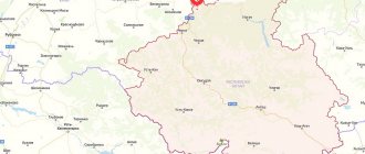
On the online map, Kursk can be found near the western borders of the Russian Federation, 150 km east of the Russian-Ukrainian border, on the banks of the Seim River and its tributaries - Tuskari, Mokva and Tsvetovsky Stream.
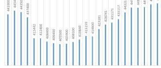
Kursk has a population of 448 thousand people.
Forests
Contrary to the prevailing picture among many, the new road through SNT does not involve cutting down forests for the construction of residential buildings. It is proposed to remove 36 hectares from urban forests in other areas: 16 hectares in the area of Engels Street and 20 hectares for multi-storey housing on Malysheva Street.
Part of the territories of some SNTs is also proposed to be converted into residential, but for individual housing construction and mid-rise buildings. The project differs from the previous general plan by lowering the number of floors: it is proposed to pay much more attention to low- and mid-rise buildings, and the potential number of houses above nine floors is to be reduced. More townhouses, fewer high-rises.
As in the previous (currently valid) general plan, Znamenskaya Grove is intended for a zone of specialized public development.
What the updated draft general plan of Kursk looks like
Articles
The draft general plan for Kursk 2022 is ready. There are still public hearings ahead, final adjustments, but the main body is here - on the table of the chairman of the committee of architecture and urban planning of the city of Kursk, Irina Anikeeva. We also have a map of the city and diagrams of individual problem solutions - adjustments to the general plan of 2008, 2016, Giprogor's proposals, comments and diagrams drawn by public activists and citizens.
— It was participatory planning, and the general plan itself turned out to be truly popular. Never before have discussions on a draft master plan been so widespread. This is connected, of course, with the development of social networks. The townspeople discussed the project vigorously, in detail, literally “under a magnifying glass.” Not a single passage or section was left unattended. In total, more than 5 thousand proposals were received, all of them were sent to Giprogor.
Again. Why was a new master plan needed?
The master plan of Kursk is being developed taking into account the long-term development of the city, with the aim of organizing new and reconstructing existing areas, providing them with transport, communal and social infrastructure. The development of the urban planning strategy was carried out with an estimated period of 20 years, that is, until 2040.
“This is a document for the future, this is a strategy for the development of Kursk,” says Anikeeva. — Why does Kursk need a new general plan? In 2019, the strategy for the socio-economic development of Kursk was approved, a comprehensive scheme for organizing traffic was developed, the boundaries of the city changed, and it was necessary to determine functional zones for new territories that became part of the city. The urban planning situation in the center has changed after the architectural competition to restore the historical and cultural appearance of “Kursk - 2032”. Also in the general plan it was necessary to display the emerging protective zones of cultural heritage sites and the flood and flood zones registered in the cadastral register. All this had to be taken into account in the main urban planning document.
What problems will the master plan solve?
People choose to live in cities where they can realize their potential, where the quality of the urban environment is high, where it is comfortable to live and raise children. Young people have been leaving Kursk for many years now. And not only because of the capital’s high salaries. In Kursk now there is no historical core, the potential of the rivers has not been used, there are no bicycle and pedestrian routes, there are many depressing places - entire blocks of dilapidated housing and abandoned industrial sites, vacant lots instead of parks, an outdated street and road network, and therefore inevitable traffic jams.
— The city development strategy is designed to eliminate all these shortcomings. Previously, all cities, including Kursk, were built according to the principle - the center and all life develops around it. This model is now being abandoned. We also intend to implement a polycentric model - to increase the connectivity of microdistricts, change the functionality of territories, saturate the life of microdistricts, use the principle of block development and integrated development of the territory,” notes Irina Gennadievna.
Kursk is expecting a reduction in the number of storeys. This does not mean that high-rise buildings will be demolished. This means that 70% of the housing that will be built will be houses no higher than 8 floors. Public spaces will not only appear, but also be filled with meaning. For example, it is planned to improve the “mound” - Anichkin Park and fill the park “Heroes of the Civil War” (Borodino) with functionality and meaning. By 2040, 25 educational projects, 39 sports facilities, 50 sports grounds (including football and basketball fields) will appear.
The green frame of the city will increase by more than 400 hectares.
— People are tired of walking around shopping centers. We do not and cannot have a Kremlin, but we do have a child. We intend to fill it with cultural and leisure meaning. There will be an art gallery, a local history museum, a creative cluster, and exhibition spaces. Kursk residents will come here, walk, and spend time with pleasure,” says the chairman of the Committee for Architecture and Urban Planning of the city of Kursk. — The general plan provides for the creation of pedestrian streets: “Malevich Quarter” - st. Postal, from st. Gaidar to the Gypsy Hill - to the ethnic element (“City of Masters”); creation of 128 km of bicycle paths.
The bicycle route “Big Silver Ring” will run along the Tuskar River along Yamskaya Sloboda - Streletskaya Sloboda - Cossack Sloboda - Pushkarnaya Sloboda - Znamenskaya Grove - st. Path - Pobeda Avenue - st. Karl Marx - Festivalnaya - in the area of st. Gudkova along the Tuskar River and connects to the beginning of the route along the Tuskar River. The “Small Silver Ring” will be laid along the Tuskar River through the settlements - Yamskaya - Streletskaya - Kazatskaya - Pushkarnaya - to Progulochnaya - Karla Marx (in the area of Gvardeiskaya Street) and connects with the beginning of the route along the Tuskar River.
— These routes are laid out taking into account viewpoints - past rivers, temples, settlements, where ethnic elements and the spirit of old Kursk will be recreated. This means that bicycle paths will not just be built, but river banks will be cleared and landscaped, the bed will be cleaned and the water level in the Kur and Tuskar rivers will be raised,” explains Anikeeva. — This will improve the environmental friendliness of living. We will not become the Netherlands, but we must create conditions for the health of Kursk residents, for their active lifestyle. We have a complex, interesting landscape; we can plan not only bike routes, but also ski routes. It is planned to build a mini-zoo, an arboretum, and a skate park - all this is reflected in the general plan. A territory is planned for each object.
Pain points. Was/Has become.
The draft master plan caused not only mass discussions, but also a wave of criticism. The authorities had to meet with residents of each district and initiative groups protesting against the construction of roads or the transfer of land from individual housing construction to a mid-rise development zone. Officials promised that all comments would be taken into account, and the categorical refusals of residents would be reflected in the general plan.
— The road on Plevitskaya through the territory of SNT in Mokva is excluded. Development in the area of Engels Passage is excluded,” Anikeeva lists. - Renovation of Gypsy Hill, Ochakovskaya Sloboda - people opposed it, proposals were excluded, the territory remained under individual housing construction. A bridge across the Krivets channel was proposed, an overpass was planned, but the residents of Gypsy Hill were against it and only a pedestrian bridge was left. All passages that people did not agree with were removed. The territory along Malykh Street from Dobrolyubova Square to Polevaya is proposed as a mixed public and business development. The fact is that there is already a court, a window factory, a temple, various shops, warehouses, bases - the functionality is enormous. If each plot is allocated a zone of permitted construction, it will be a patchwork quilt. Therefore, mixed public and business development is best suited for this area. There may be housing there, of any number of floors. The same zone has been installed in the center of Kursk, where we have a shopping center, residential buildings, offices, social institutions and much, much more.
The compromise was the road that should connect Engels and the PLC.
— The construction of this road was provided for by both the 2008 general plan and the 2016 edition. It is necessary because even the reconstruction of Kulakov will not relieve the difficult traffic situation. I will say right away that there will be no demolition of houses or cutting down of trees. Instead of 4 lanes there will be 2 lanes that will run along the former railway line. There is an embankment that can accommodate 2 lanes,” Anikeeva emphasizes. — Once again: the forest will not be cut down.
Residents of SNT “Druzhba”, “Mokva”, “Kommunalshchik” asked to transfer the land from garden plots to individual housing construction.
— This will remain the territory of garden plots. Why? I'll explain now. These are old dachas, where the plots have long been divided. You can build on them, register housing and live. But the passages do not allow either ambulances or fire trucks to pass through. Given the existing division, neither social nor road infrastructure can be provided. If we display this individual housing construction zone, then we need to build roads, which means we need to seize land. It is necessary to build a school, a kindergarten, a clinic, which means confiscating the land so that there are no such consequences and leaving the gardens there. We said, if you bring the minutes of the decision of the general meeting on the transfer of land to individual housing construction, we, of course, will make changes. They didn't bring it.
There will be construction in the Fiber microdistrict. But it’s not just high-rise buildings that will appear.
— Here the question remains open. People say “here is a meadow,” but it is not a meadow. If this is a conservation area and its value is established, then there will be no construction. Now this is a zone where medium-rise buildings are expected, where integrated development of the territory is envisaged. What does it mean? That the owner will contact the city and receive the task of building not only social facilities - a school, kindergarten, clinic, but also a mini-zoo, arboretum, skate park, public spaces. The land here must be used efficiently.
Another road that the city needs is on Ponyrovskaya and Lev Kononov. It was provided for by the general plan of 2008 and 2016.
— In the immediate vicinity are the Tropinki and Metro areas, which are currently being actively developed. In addition to Instep, there are other developers here; a wedding palace, a school for 550 students and a kindergarten for 280 places are planned. The road will have 2 lanes, instead of the originally proposed 4 lanes. It will allow you to immediately go to Ponyri, beyond the city border. It must be considered in the context of the entire road network of the microdistrict. Festivalnaya Street is envisaged as an understudy for K. Marx - there are always traffic jams here. The microdistrict is growing, a new interchange will not save it, a backup is needed, which means other bypass routes are needed. The backup will provide access to Severny. People wrote that there is a road along Rosinka, and it works. But she's coping so far. There will be high-rise buildings on Pobeda Avenue, where the former military base is. The population will increase. The artery of Pobeda Avenue and K. Marx needs to be unloaded. The road will pass along the embankment of the former railway line of the military road.
Only this year, residents of the Fighters of the 9th Division, the Red Army, Akhtyrskaya, Pavlunovsky saw that the construction of multi-storey housing was possible there.
- There is no need to panic. No one will take the housing. You have been living there since 2008, selling, buying, donating, inheriting, privatizing - there are no encumbrances or restrictions. No one will be deprived of property, no matter how dilapidated it may be. No one will buy your 10 acres; you need to negotiate with one and another neighbor. If a developer comes there, he will not be able to offer you a price below the market price. He will negotiate with you. The city is not involved in this. This is not a comprehensive development of the territory; no withdrawal is possible. You have an individual housing construction, and it remains. But you cannot decide for your grandchildren and neighbors. The master plan is a document for the future and must take into account the interests of all residents. It is possible to build high-rise buildings on these streets, but not higher than 8 floors.
Severny village, microdistrict No. 4.
“There was individual housing construction there, but the owner is free to dispose of his property, now the integrated development of the territory is provided there, the city administration cannot limit the owner,” explains Anikeeva.
The residents of Kursk asked to make a passage so that residents of Parkovaya and Chernyakhovsky could get to the street. Seregina, bypassing Kulakov. This proposal has been taken into account.
— Well, in Sumskaya, those areas that left the forest for another zone returned to the forest. Proposals for housing construction in Kislinsky, Promyshlenny lanes, Oboyanskaya, Sumskaya, Olshansky, Internatsionalnaya have been heard. There will be renovation of the areas; medium-rise buildings are expected to replace dilapidated and dilapidated housing. Renovation also awaits Gremyachenskaya, Aggregatnaya, Mokovskaya, Magistralny proezd, Lesnaya. Where there was an industrial area there will be housing. At the Lgovsky turn, where the ring is, a multi-level interchange is expected,” Irina Gennadievna lists the changes made to the draft general plan.
Kursk residents will be able to add their comments to the draft main urban planning document for the last time during public hearings. November 26 - residents of the Railway District, November 27 - residents of the Central District, November 28 - residents of the Seimsky District.
“By the end of the year, Kursk will have a new general plan,” summarizes Anikeeva.
interviewed by Tanita Ortega.
Author: Tanita Ortega
Public spaces
Giprogor proposes to make Pochtovaya Street pedestrian - from Semenovskaya Street to Radishcheva Street - to create an art space there. It is planned to make Lunacharsky Street another pedestrian street.
It is proposed to leave the area around Dzerzhinsky Street as a shopping and entertainment area, but to create a pedestrian zone. It can start on Gaidar Street, go through Antokolsky Street, Chisty Lane and up to Krivetskaya Street. At the end of the route, on the Krivets River, it is planned to protect the embankment from flooding to create a “craft village” there. Accordingly, the project involves the creation of pedestrian bridges throughout the pedestrian zone.
Cemeteries
At the request of the mayor's office, areas were provided for the expansion of cemeteries. It is proposed to add 22 hectares to the Northern one, and another half a hectare to the Muslim cemetery on Krymskaya Street.
The crematorium, as previously reported, cannot be located within the city due to the kilometer-long security zone: the Kursk region will be considered for it.
It is worth noting that the residents of Kursk, faced with a lack of clarification on the draft general plan and the absence of a “people’s” presentation, study it on their own: for example, in the public “Renovation of the Nightingale Region” an author’s analysis of the project in various areas appeared.
Yan Yezhov
- #General plan
- #SNT
Kursk on the map of Russia – where it is located. Geography of the city
Kursk on the map of Russia is located in the Black Earth Region, in the center of the Kursk region, on the banks of the Seim River and its tributaries - Tuskari, Mokva and Tsvetovsky Stream. The distance from Kursk to the Russian-Ukrainian border is about 150 km.
Distance from Kursk to major cities by road:
- Moscow – 530 km north,
- Bryansk – 280 km to the northwest,
- Sumy – 160 km to the southwest,
- Belgorod – 140 km to the south,
- Voronezh – 230 km to the east.
Kursk stands on the southwestern slopes of the Central Russian Upland with a complex terrain characterized by many gullies, ravines and river valleys. The average height in the city is 250 meters.
The city is located in the forest-steppe zone, on the border of steppes and mixed deciduous forests.
The climate is temperate continental, with mild winters (average January temperature -7 C°) and warm, moderately hot summers (average July temperature +21 C°). Spring and autumn are long and usually warm. The average annual temperature is +8 C°. Approximately 620 mm of precipitation falls per year, the rainiest month is June (74 mm), and the driest months are February and April (37 mm of precipitation each).