The Murmansk region is an unusual region in many ways. Despite the fact that it occupies one peninsula, the variety of landscapes in its different parts is stunning in beauty. Here, endless swamps and high mountain ranges, open tundra and taiga forests coexist; on the seashore, sandy beaches turn into massifs of inaccessible rocks.
The Kola Peninsula of the Murmansk region is a paradise for geologists who can find here many varieties of ornamental stones and rocks. Ethnography lovers will be interested in the villages of the Kola peoples, and those interested in nature will be delighted by the Lapland and Kandalaksha nature reserves.
Church of the Assumption of the Blessed Virgin Mary (Varzuga)
The restored Church of the Blessed Virgin Mary (1674) in the village of Varzuga, Murmansk region, is a remarkable architectural monument, built without a single nail. The Assumption Cathedral is very beautiful and is the ideal creation of a great master. From a distance he seems perfect and surprisingly slender. Its silhouette seems to merge with the surrounding area. Up close, the church looks beautiful, solemn and majestic. The height of the main volume of the cathedral is 13 m, and the rest of the superstructure is 21 m. This size ratio is the “golden ratio of the pyramid”. The roof of the cathedral building has the shape of an equilateral cross.
The beauty of the structure was achieved not only by the slender forms, but also by the external decorative decoration - the presence of many porch columns, beautiful carved details, window casings, lace framing of the lower and upper parts of the dome, patterned ends of the plate roof, barrel ridges and piers. All parts were made of wood of different shades: from dark and red-brown to golden and silver-white. In the sacred place there is a beautiful iconostasis, which includes 84 icons.
The Assumption Church has survived to this day, but not in its original form. Despite some changes, the holy place has not lost its artistic integrity, simplicity, harmony and solemnity. The Assumption Cathedral is the best among the wooden tented monasteries of the north.
Ship cemetery in Teriberka
Right next to the highway on the way to Lodeynoye (the new part of the village of Teriberki) at the mouth of the Teriberka River at the fork there is an interesting location that leaves ambiguous impressions.
Those who have never seen anything like this will find it very interesting. Here, in a small bay, the remains of about 12 ships are scattered. An unusual, fascinating place.
The appearance of large vessels and their limited ability to enter the port of Teriberka affected its fishing. Fishing began to be carried out further into the sea. The fish processing plant closed. They began to leave the old ships in the bay; here they do not bother anyone. The ship cemetery began to form in the 60s of the last century.
One of the ships is a picturesque pier, its skeleton is covered with earth, its stern protrudes into the water. Parts of ships, reminiscent of the bones of huge ancient animals, are scattered chaotically nearby.
Wooden and metal skeletons of ships live out their days in the bay. Despite their abandonment, they have become a tourist destination. The photos here turn out different. At low tide, parts of the ships overgrown with moss are exposed, and everything looks quite sad, when the tide comes in and the remains are not completely visible - quite picturesque. Strong storms slightly change the location, and the rusty skeletons remember how they went out to sea.
For some, this place evokes philosophical thoughts about the last refuge and the finitude of everything in the world. Someone feels like a sea traveler, looking into a remote corner of the ocean.
Interesting facts about the Ship Graveyard
- Photos of ships against the backdrop of the northern lights turn out fantastic.
- It is possible to climb into some ship wrecks, but you must be extremely careful.
Museum of Mineralogy and Geology
The museum was created in the 30s. in the city of Apatity, Murmansk region. During the Great Patriotic War, a fire at the station where the building was located destroyed all the collections. In the post-war years, a new, no less valuable collection was created at the Geological Institute.
The museum's collections contain more than 9,000 thousand different samples of ores, minerals and rocks of the Kola Peninsula, most of which are unique and rare. The exposition of the unusual place is presented from: a collection of ores and other minerals, a collection of unusual and beautiful rocks, a systematic collection of minerals, as well as a collection of the latest minerals found in the location of the Kola Peninsula.
Also in this place are collections of igneous, metamorphic and sedimentary rocks, the number of which exceeds 900 specimens. On the territory of the Kola Peninsula there are large deposits of cobalt, apatite, various rare metals, ceramic and high-alumina raw materials, facing and ornamental stones. The museum presents more than 800 representatives of ores and minerals of the Murmansk region.
Northern corrosion station
In the Kola region, between Zelenetskaya Bay and Yarnyshnaya Bay, the village of Dalnie Zelentsy is located, which is part of the Teribersky settlement. It is located 37 km from Teriberka. The village is almost abandoned, but interesting objects have been preserved in it.
The village is a meteorological station, a seasonal branch of the MMBI (Murmansk Marine Biological Institute), a border part. A diving center was opened here in 2010, and the Northern Corrosion Station has been operating since 1948.
Dalnie Zelentsy is a former science city. In 1935, he began life with a biological station, in 1958 there was MMBI, in the 1980s - the best marine biological station in Russia with excellent equipment and capabilities. The institute had its own vessels for work at sea. In the neighboring Oscar Bay, with strong low tides (up to 4 meters), it was convenient to study marine life, algae, and take water samples. There is a wide variety of Arctic flora and fauna here. In 1989, the institute was transferred to Murmansk, which became the death of the village.
Almost all the buildings in the village belong to the institute, but you can’t argue with nature. They are in a deplorable and abandoned state, northern nature is taking everything for itself. The layout of the village was good, the buildings were interesting, the architecture was unusual. There is a kind of beauty, detachment, peace here.
Algologists work seasonally in the village to study unique algae (these organisms, together with some bacteria, purify sea waters from oil products). Fishermen and divers live here.
From the institute building, walkways lead to the Northern Corrosion Station of the Institute of Physical Chemistry and Electrochemistry (Institute of Physical Chemistry and Electrochemistry), this is one of the four stations of the institute and the only one in the Arctic.
It is a fenced area lined with 17 stands with various samples of metal alloys mounted on them. Some have been here since the 1980s. At the station, observations were made of metals and their alloys and their behavior in northern conditions. Automotive and aviation companies sent samples here, as did defense and space institutes.
Now the station is operating, but not at all on the same scale. At the stands, in addition to testing for atmospheric corrosion, the metal was checked for bending and welds were tested. Non-metallic materials were monitored for their climatic aging. One stand holds the fighter's plexiglass cap. Here they tested products coated with oils and packaging materials. The properties of materials and their safety under environmental influences were determined. A couple of sites are located in close proximity to the sea.
There is information that the station is looked after by one woman, station manager L.G. Berezina, who has been working here for more than half a century. There are practically no orders now.
The station was created at an altitude of 32 meters above sea level, with a distance of 150-300 meters from open sea water, on an area of about 10,000 m2. The entire area is covered with sand, overgrown with low tundra vegetation.
Many students and family employees worked in Dalniye Zelentsy who remember this cozy corner very well. It's a pity that this village is practically lost.
Interesting facts about the Northern Corrosion Station
- A weather station is adjacent to the corrosion station.
- Brand new houses are a hub for divers.
Lapland Nature Reserve
The Lapland Nature Reserve is located in the western part of the Kola Peninsula near the beautiful Lake Imandra in the Murmansk region. The main value of this beautiful place is its untouched wild nature, which is in its pristine natural state. The area of the Lapland Nature Reserve is 278 thousand hectares - this is the largest protected area in the Murmansk region and Europe.
In these beautiful places, the climate softens the influence of the warm Atlantic Current. The average temperature in the coldest month (February) is about -130C. The white night season in the Murmansk region lasts for 100 days, and the polar night lasts 25 days.
The area is rich in animals, here you can find elk, brown bear, wild reindeer, fox, marten, wolf, otter, etc. Among the birds you can see the Lapland chickadee, jock, woodpecker, hawk, white-tailed eagle. The reservoirs are home to 13 species of fish, 6 of which are salmon, reaching a weight of 4 kg. The flora is dominated by pine and spruce forests with birch and aspen forests; the forests contain a wide variety of berry bushes - blueberries, lingonberries, blueberries. In 1995, the management of the beautiful Lapland Nature Reserve approved the project “Fabulous Lapland – The Domain of Father Frost,” whose tower is located on the shores of Chunozero.
Sredny Peninsula
The Sredny Peninsula is the north of the Kola Peninsula. It is located between the Kola landmass and the Rybachy Peninsula. Belongs to the Pechenga district. It is washed by the waters of the Barents Sea, from the west - Malaya Volokovaya Bay, from the east - Bolshaya Volokovaya, and is connected to the mainland by the Musta-Tunturi ridge. 25 * 13 km - the size of the Medium, heights up to 334 meters.
First of all, the Sredny Peninsula is a military memory; there are memorials, military graves, and pillboxes everywhere. The cruel time has left its deep mark. And, of course, the Middle has its own natural beauty. The peninsula is a plateau that sometimes drops steeply into the water. There are unearthly views here, many lakes, streams, low vegetation trying to cling to everything it can. Open areas give way to low bushes and here and there birch trees. There are thickets of lingonberries and blueberries. Very expressive rocks are formed by shale, sandstone and limestone. The sea does not freeze due to the warm current. In the Middle there is an abundance of fish.
The peninsula begins with the Musta-Tunturi ridge, where the heaviest battles took place. There is a museum of defense of the Sredny and Rybachy peninsulas, which is rich in military artifacts. Nearby, at the foot of the peak, there is a memorial and a large burial ground, above there is a small chapel with a bell. Nearby are underground passages, fortifications and a lot of metal in the form of wire, cartridges and other remnants of the military past.
Moving along the west coast, you can see the waterfalls that are formed by the river flowing into the lip.
Another memorial with a gun barrel from Ponochevny’s battery, with the salvo of which the war began for the Northern Front. The legendary 221st battery is a hero of the Second World War. Almost nothing has survived from it; in the 50s, 4 gun blocks, a command post, and a power station were fixed here. For a long time, the guns were stored mothballed, thickly lubricated with grease. Now, thanks to the availability of objects, a lot has been stolen. Abandoned underground buildings can be penetrated.
In the north, the peninsula ends at Zemlyany Cape. Along the road there are very picturesque steep canyon cliffs, consisting of layered shale; on the other side there is the Bolshaya Volokovaya Bay. And here, on the rocks, the structures of firing points have been preserved. Two famous rock outcrops “Two Brothers” appear near the shore. They stand a short distance from each other on hills covered with greenery. They look very impressive. This is a place of worship for the Sami people; sacrifices were made here.
A few kilometers from the remains there is the amazing Coast of Red Stones. Boulders, stones of various unusual alien shapes, reddish in color, weathered, carved by the wind. A very photogenic place.
The eastern side of the peninsula also preserves military memory; there is a memorial to pilots at the former Pummanki field airfield, and near Motovsky Bay there is a memorial to artillerymen.
Interesting facts about the Sredny Peninsula
- The weather in the Middle is constantly changing.
- It is believed that there is no need to go between “Two Brothers”.
- In K. Simonov’s poem “The Artilleryman’s Son,” military operations in which the heroes participate take place in the Middle.
- In the book “Orphaned Shores” M.G. Oreshety - a detailed description of the plight of the Sredny and Rybachy islands during the Second World War.
Museum of the History of the Kola Sami
The museum was founded in 1962 in the village of Lovozero, Murmansk region. It was founded in 1962 by high school teacher P. P. Yuryev. The exhibits of this place tell about the culture, life and history of the Sami - the indigenous inhabitants of the Kola Peninsula. The northern people still live today in Sweden, Norway and Finland.
Here are models of ancient houses, objects of applied art, everyday life and clothing, a diorama with a reindeer team, and tools. Also in this place you can see a pyrt or tupa - a dwelling where the Sami lived in the winter; kuvaksu - portable tent, vezhu - at home in fishing grounds.
The museums display archaeological finds from various time periods. Also in this historical place there is an unusual stone with beautiful rock paintings, brought in 1988 from the city of Chalmny-Varre. Large exhibits are ideally complemented by photographs, documents and reproductions from different eras. The museum introduces its visitors to the development of the region from ancient times to the present day.
Observation deck of the Komsomolskoye deposit quarry
Of course, this quarry is not as large as the coal mines of Kuzbass and not as deep as the diamond mines in Yakutia, but it is located not far from the federal highway, near the city of Olenegorsk and it has an excellent observation deck to which there is free access. The quarry for the development of the Olenegorsk iron ore deposit is quite young, it has been developed since 1998.
From the observation deck you can clearly see the entire iron ore mining process; you can watch the work of quarry excavators and quarry shovels.
Waterfall on the Chapoma River
The beautiful waterfall is a state hydrological natural monument of the Murmansk region. This is the largest waterfall in the Murmansk region. An amazing place is located in the southeast of the Kola Peninsula on the Chapoma River, 8 km north of the mouth.
Chapoma waterfall consists of 4 rapids, the highest is at an altitude of 20 m. The current of Chapoma in this place is very fast and stormy. Rocks rise majestically above the banks of the river, forming a picturesque canyon. Over the course of 1.5 km, the waterfall forms a height difference of more than 29 m.
The vegetation near the waterfall is represented by beautiful taiga forests with many epiphytic lichens, as well as a developed moss and herb-shrub layer. The most common in these places are forest geranium, horsetail, hellebore, cloudberry, as well as a rare plant listed in the regional Red Book - Maryin Root.
Maloe Batareiskoye Lake
Maloe Batareiskoe Lake is located on the shore of the Barents Sea near the villages of Lodeynoye and Teriberka.
It is hidden among rocky hills covered with greenish and whitish reindeer moss. The reservoir fits very beautifully into the area. The surrounding hills seem to protect him. You can drive to the lake and along it by car or walk, which is, of course, preferable. A very picturesque place. There are many lakes here and they are located at different altitudes. They often open up unexpectedly. Maloe Batareiskoe is perhaps the most picturesque. The name comes from an old artillery battery located a little further.
The plants here are not tall, but in the warm season they cover everything around, even the rocks, with bright greenery, colorful northern plants, and flowers. The lake boasts very clear blue water. It is shallow and warms up over the summer, so there are people who want to swim. From any point, the place is very beautiful and is one of the most visited natural monuments of Teriberka.
There is a sandy beach nearby. Above is Battery Lake. Batareiskoye and Maloye Batareiskoye are connected by a stream. From Batareyskoye the stream, forming a small waterfall, flows into Maloe Lake.
Interesting facts about Maly Batareiskoye Lake
- Tourists put up tents and stay overnight on the lake.
- The attractions of Teriberka are located close to each other, so it will be interesting to visit them together.
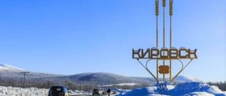
Khibiny Snow Park-Kirovsk
The complex is located closer to the south-eastern part of Kirovsk. You can get here from any part of the city quite quickly.
This complex in the city is often called a children's school. Initially, it was built specifically to teach children skiing.
Now Khibiny Snow Park is the only center where children from 4 years old are taught for free. Young skiers are provided with all equipment free of charge.
Stable snow cover appears at the end of November and lasts until April.
But here there are often snowfalls with strong winds, which does not allow skiing from the slope. They usually last 1-2 days, but in rare cases they drag on for a week.
You can get to Snow Park from anywhere in Kirovsk by minibus, bus or taxi. A tourist in his car must first get onto Lenin Avenue and turn from it onto the street. Soviet Constitution.
POPULAR WITH READERS: Novoperedelkino: a union of capital service and beautiful nature
Trails
There is only one slope in Khibiny Snow Park, its length is 300 meters. The track is constantly maintained, so you don’t have to worry about any troubles while skiing.
For small children there is a separate slope for cheesecake skiing. You can go up using a rope tow.
In the evening, artificial lighting is turned on, and during the polar night it practically does not turn off.
Apart from skiing, there is no other entertainment in Snow Park, but you can warm up between slopes with hot drinks and fast food from a local kiosk.
Accommodation
Tourists who stay in Kirovsk for several days can stay at one of the city’s hotels.
Rooms to choose from - from budget options to luxury. The closest hotel is the Gornitsa Hotel, which has a sauna, cafe, billiards and an indoor pool.
Pros of Khibina Snow Park:
- Convenient transport location.
- Opportunity to train children under the guidance of a competent instructor.
- Availability of lifts.
- Long skiing season.
Khibiny Snow Park is unlikely to be suitable for experienced skiers and those who want to experience extreme sensations.
But this complex within the city is perfect for active recreation for beginners and those who just want to enjoy skiing after work or on a day off.
"Polar Kaleidoscope"
Duration:
3 days/2 nights.
Route:
Murmansk - Kirovsk - Teriberka - Lovozero.
This is a branded route that will begin with a sightseeing tour of Murmansk with a visit to the world's first nuclear icebreaker "Lenin". On the second day, tourists will go to Teriberka, where they will be able to see a beautiful waterfall flowing directly into the ocean.
Next, guests of the region will visit the Lovozero region: they will visit the open-air museum “Sami Village”, where they will get acquainted with the culture and life of the Sami people, ride reindeer, and ride ATVs.
Explore the route
White Sea
Without a doubt, the main natural attraction of the Murmansk region is the White Sea, which affects both the economy of the region and the weather.
In summer, waters near the coast can warm up to + 18-24 degrees Celsius. In October-November the sea begins to freeze and remains under ice until May, although the entire sea area does not freeze. The sea has a great influence on the temperature of the area. The average January temperature on Solovki (Solovetsky Islands) is about -10 ° C, in February, when the influence of sea heating decreases, the average temperature drops to -12 ° C. The average sea salinity is 23-25, which is lower than in the Barents Sea sea, and is explained by the large flow of fresh water from the rivers.
There are not many islands in the sea. The largest Solovetsky Islands are in the eastern part of the sea, where the famous Solovetsky Monastery is located. Among others, we can mention the Kuzova Archipelago, with its interesting archaeological and natural attractions. Several small islands in Kandalaksha Bay belong to the Kandalaksha Nature Reserve.
The natural diversity of the sea is great. It is home to about 60 species of fish, including Atlantic salmon, Pacific salmon (introduced by humans), cod, navaga, herring, flounder, etc.
“Rafting and fishing along the Indel-Varzuga rivers”
Duration:
6 days/5 nights.
Route:
Kandalaksha - Indel River - Pana River - Varzuga River.
This is a great family holiday in the North. The simplicity of the rivers allows rafting with any level of experience, and the beauty of the Russian North will make rafting unforgettable.
An obligatory part of the rafting trip is licensed fishing for salmon, grayling, and pike. Overnight - in a tent camp.
Explore tour