Story
Kingisepp district was formed in 1927. In 1931, its territory expanded due to the abolished Kotelsky district. During the Second World War it was under occupation and suffered greatly. At the end of the war, in 1945, he received part of the territories of the Estonian SSR, on which the village of Ivangorod was located.
In 1963, the Kingisepp rural swarm was created, which also included the territories of the abolished Slantsevsky and Volosovsky districts. However, in 1965, the territory of the Volosovsky district was again separated. In the same year, but a little later, the Slantsevsky district was separated. It is worth noting that such transformations are typical for the Leningrad region; this happened everywhere.
In 1996 it received the status of a municipal entity. In 2006 it was finally formed in its modern form.
Greetings from the head of the administration of the Kingisepp municipal district, Viktor Evaldovich Geshele
Victor Geshele Head of Administration of the Kingisepp Municipal District
Dear friends, fellow countrymen and guests of the Kingisepp municipal district!
In the coming new year, 2014, we decided to modernize our communication channel with you on Lenoblinform. We want the page of the Kingisepp municipal district to become more information-rich so that you can receive the latest and most relevant news from our municipality.
You can ask all your questions online at the reception desk on the official website of the municipal district administration or during the reception of citizens, the schedule of which can also be found on our website.
As for our page on Lenoblinform, here you will find a lot of interesting and useful information: news from the life of our district, materials about the achievements of institutions and enterprises, about the implementation of various interesting projects in the Kingisepp district. We have something to be proud of and something to talk about on the pages of the virtual space. Follow our page for news and updates.
We hope this page will be very helpful to area residents. Thanks to this internet page, not only residents of the Leningrad region, but also other regions of Russia and the world will learn more about the Kingisepp region, its grandiose construction projects, projects, people, and achievements.
With best wishes, Head of Administration of the Kingisepp Municipal District Viktor Evaldovich Geshele.
Blog archive by V. Geshele
Population and administrative structure
The population of the Kingisepp district is 78.8 thousand people. 72.5% of the population lives in urban areas. The national composition is dominated by Russians. The population is decreasing; the maximum was recorded in 2014 – 79.6 thousand people.
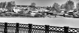
Kingisepp district consists of 2 urban and 9 rural settlements, which include 190 settlements. The urban settlements are: Ivangorodskoye with the administrative center of the city of Ivangorod (total population 10,460) and Kingiseppskoye with the administrative center of the city of Kingisepp (total population of 46,750).
Table. Rural settlements of the Kingisepp district.
| Name | Center | Population | Settlements included |
| Bolshelutskoe | Village Kingiseppsky | 4700 | 22 |
| Vistinskoe | Vistino village | 1750 | 19 |
| Kotelskoe | Kotelsky village | 3600 | 44 |
| Kuzemkinskoe | Village Bolshoye Kuzemkino | 1400 | 18 |
| Nezhnovskoe | Village Nezhnovo | 900 | 21 |
| Opolevskoe | Village of Opole | 2800 | 22 |
| Pustomerzhskoe | Tree Big Hollow | 2300 | 18 |
| Ust-Luga | Ust-Luga village | 3100 | 12 |
| Falileevskoe | Village of Falileevo | 1100 | 9 |
Place of Kingisepp district in Leningrad region
Kingisepp municipal district is a municipal entity in the southwestern part of the Leningrad region. The administrative center is the city of Kingisepp. Formed in 1927. Historically, it was preceded by the Kingisepp (formerly Yamburg) district of the Leningrad (formerly Petrograd, St. Petersburg) province, created in 1783.
In the northeast it borders with the Lomonosovsky municipal district, in the east with the Volosovsky municipal district, in the south with the Slantsevsky municipal district and in the west with Estonia. From the north, the territory of the region is washed by the waters of the Gulf of Finland.
The territory of the region has a flat terrain, absolute heights are 0-150 meters above sea level. To the east of Luga Bay there is the Soykinskaya Upland, and in the valleys of large rivers there are lowlands (Luzhskaya and Plyusskaya). The Baltic-Ladoga ledge (clint) passes through the territory of the region. In the area there are deposits of phosphorites, construction sand, glass sand, and diatomite (abrasive).
The Luga, Narva, and Plyussa rivers flow through the area. Also in the area is the Narva Reservoir, the surrounding areas are swampy.
The population in 2006 was 81.6 thousand people.
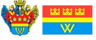
Kingisepp district has a coat of arms and a flag.
The coat of arms of the district was approved by decision of the Council of Deputies of the district No. 253-s dated December 20, 2006. Its heraldic description reads: “in an azure (blue) field there is a golden sun (without an image of a face) and an eagle flying towards it, visible from the back, placed in a baldric and accompanied at the end by a silver wall, made of blocks and walled with black, with two towers having scarlet (red) pointed roofs, along the edges and black loopholes; on top of the wall is a narrow azure tip in the form of waves running to the right.”
The district flag was approved by decision of the District Council of Deputies No. 254-s dated December 20, 2006. Its description reads: “the flag of the Kingisepp municipal district is a rectangular blue panel with a width to length ratio of 2:3, carrying along the lower edge an ornament in the form of running waves highlighted with a lighter blue outline, and close to these waves is an image of a white fortification with two towers , with red roofs and with masonry seams and loopholes highlighted in black; above the fortification there is a yellow eagle in flight; there is a yellow sun in the roof.”
Geography, relief and climate
The area of the Kingisepp district is 2907 square kilometers. It borders with Estonia, as well as with the Volosovsky, Lomonosovsky and Slantsevsky districts. In the north-west it is washed by the Gulf of Finland, the length of the coast is 105 kilometers.
The terrain is mostly flat, in some places there are hills with heights of up to 150 meters. Most of the territory of the Kingisepp district is covered with forest, dominated by birch and aspen. Pine and spruce, characteristic of most areas of the Leningrad region, are rare here. The share of agricultural land is also large.
There are several large lakes, in particular Babinskoye, Glubokoye, Sudachye, Khabolovo, Kopapskoye. In the southwest, on Russian territory, the Narva Reservoir is partially located. It is also worth noting that this part of the Kingisepp district is swampy. In general, the number of lakes is small. There are rivers, the largest of which are Narva and Luga.
It is worth noting that part of the Kingisepp district is officially recognized as affected by the accident at the Chernobyl nuclear power plant. It is not recommended to pick berries and mushrooms here, as they contain a high content of cesium-137. Of course, local residents are not particularly concerned about this, but we still do not recommend buying or picking mushrooms and berries here.
The climate is temperate continental, which distinguishes it from other areas of the Leningrad region. However, the average annual air temperature does not differ from the regional average. However, the average annual precipitation is lower - 625 millimeters. The weather is changeable, with frequent pressure changes.
Kingiseppsky district is located in the southwest of the Leningrad region. Almost 50% of the length of the region’s border is a border zone, a tenth of it is with Estonia, and the rest is access to the Baltic Sea, to the countries of Scandinavia and Europe. It borders in the northeast with Lomonosovsky, in the east with Volosovsky, in the south with Slantsevsky districts of the Leningrad region. The Kingisepp district also includes a number of fairly large islands: Gogland, Moshchny, Seskar and others. The district includes the territories of the cities of Kingisepp and Ivangorod , as well as 9 rural settlements. The administrative center of the district is the city of Kingisepp .
The area of the district is 290.8 thousand hectares. The population of the district in 2010 was 78,183 people.
Since ancient times, these lands were located at the intersection of water and land routes from North to South and from West to East. The oldest inhabitants were small Finno-Ugric tribes - Vod, Izhora, Chud. The Slavs began to settle in the basins of the Narva and Luga from the 5th-6th centuries. Later, the territory of the district became part of Veliky Novgorod.
At the end of the 14th century, Novgorodians built new fortresses, placing them closer to the border. The main line of defense of the state ran along the Luga River, where a new outpost was erected - the Yam fortress. In 1384, the Novgorodians, as stated in the chronicle, “built the city of Kamen on the Luga River - Yama.” From Yam the city of Yamburg subsequently grew.
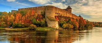
In 1492, Tsar Ivan III decided to strengthen and equip the western border of the Russian state. of Ivangorod was founded at that time , occupying 45 thousand square meters. meters. Not only the soldiers of the garrison lived under the protection of impressive walls, but also the townspeople.
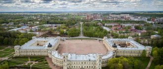
Yamburg After the Northern War, Yamburg lost its significance as an outpost of Russia, and at the beginning of the 19th century, the fortress of ancient Yam ceased to exist. Today, only high earthen embankments, the bases of stone walls and towers on the river bank, and a pond that once served as a moat remind of it. The main attraction and symbol of the city is St. Catherine's Cathedral, erected on the city square at the end of the 18th century according to the design of the architect Rinaldi.
In 1922, Yamburg was renamed Kingisepp in honor of the Estonian communist Victor Kingisepp. During the Great Patriotic War, the city was almost completely destroyed and was reborn with the construction of the chemical industry giant Phosphorit in the early 60s.
The Kingisepp district was formed in 1927 as part of the Leningrad district of the Leningrad region; it became one of the four districts into which the Kingisepp district was divided. In 1930, due to the liquidation of the districts, it entered directly into the region. In January 1931, the territory of the abolished Kotelsky district became part of the Kingisepp district. From 1935 to 1940, the Kingisepp district was part of the Kingisepp district, which also included the Volosovsky and Osminsky districts.
In 1945, part of the territory of the Estonian SSR east of the Narva , including the village of Ivangorod, was included in the district. In 1954 , Ivangorod received city status. In 1963, the Kingisepp rural district was formed, which included the territory of the former Kingisepp, Volosovsky and Slantsevsky districts. In January 1965, the Kingisepp rural district was transformed into a district, and the Volosovsky district was again separated from it. In November 1965, the Slantsevsky district was separated from the Kingisepp district .
Today the area has a wide industrial orientation, is based on its own natural resources and has high economic potential.
Within the district are the lower reaches of two navigable rivers: Narova and Luga . The length of the coastline of the Gulf of Finland is 125.8 km: Narva Bay , Luga Bay , Koporskaya Bay . Luga Bay is suitable for the passage of sea vessels and practically does not freeze in winter.
Within the boundaries of the region there are 11 lakes, the largest of which are Kopanskoye, Lipovskoye, Beloe, Glubokoye, Babinskoye, Khabolovskoye .
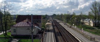
The area is crossed by several railways and highways, including those connecting the second largest city in the country, St. Petersburg, with the capital of Estonia, Tallinn.
The following railways pass through the region: Mga - Gatchina - Weimarn - Ivangorod, St. Petersburg - Kalishche - Kotly - Ust-Luga, Kotly - Weimarn, Weimarn - Gdov
The following main roads pass through the area: M11 ( E 20 ) “Narva” St. Petersburg - Ivangorod , A121 St. Petersburg - Pervoe Maya, P35 Koporye - Taraika, P38 Gatchina - Opolye, P42 Koskolovo - Peleshi, P60 Ust-Luga - Gdov
The seaport of Ust-Luga is one of the most dynamically developing in Russia.
The islands of the Gulf of Finland are of potential interest for the development of international yacht tourism. A special position among them is occupied by Gogland - the largest and most interesting island in the eastern part of the bay, which has unique natural features and conditions for sheltering yachts in bad weather during transitions from one place to another.
reserve “Kotelsky” has been created on the territory of the region , where elk, wild boar, fox, badger, and marten live. And in the north-eastern part of the region there is another small complex reserve of regional significance “Oak groves near the village of Velkota” .
On the territory of the region there is a wetland of international importance "Kurgal Peninsula" , which is of great importance for ornithologists, because More than 200 species of birds can be observed here.
The territories of a number of settlements in the Kingisepp region are officially recognized as contaminated as a result of the accident at the Chernobyl nuclear power plant.
Among the historical and cultural attractions of the area, the following can be noted:
Yam fortress in Kingisepp
Romanovka Park , the former estate of K. I. Bistrom in Kingisepp.
The estate of Gryzova , Shcherbatov, Obolensky in Velyka Pustomerz. The estate building has not survived.
Remains of an estate in Bolshoye Kuzyomkino .
Manor of Litta , Igumnova, Tyutcheva in Valgowice
Estate of Razumovsky , Blokov in Velkot. Only the coachman's house has survived.
Estate of Fredericks , F.K. Balts in Domashovo. The historical building has not survived.
Park of the former estate of Baron Stieglitz “Kramorskaya” in Ivangorod .
Albrecht estate in Kotly.
Rotkirch estate in Novopyatnitsky. There is a military unit in the estate building.
Manor Park in Onstople.
Manor park in Pahar.
The Bippen estate in Preobrazhenka. The estate is closed to visitors. There is a rehabilitation center in the estate building.
Korfov manor park in Sale.
Estate, park in Old Garkolovo.
Albrechts' estate in Consolation.
Soykinsky Shrine - the Church of St. Nicholas the Wonderworker on the Soykinsky Peninsula.
Operating museums:
Museum of History and Local Lore in Kingisepp
Izhora Folk Museum in Vistino
Fortress-museum in Ivangorod
Art gallery (former mansion of the merchant I. Panteleev) in Ivangorod
There are also a large number of churches and chapels located in the settlements of the region.
Official websites of the district administration: www.kingisepp-mo.ru and www.kingisepplo.ru
Economics and transport
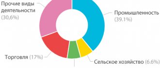
The economy of the Kingisepp district focuses on industry, where three areas are distinguished:
- Chemical industry;
- Food;
- Glass
Agriculture specializes mainly in dairy farming. It is also worth noting the developed trade, which is facilitated by transit through the area.
There are four railway lines, one to St. Petersburg. The Narva highway also passes through the area. The port in Ust-Luga is one of the most developing in Russia. Its cargo turnover is steadily growing, and there are plans for further development, which will have a beneficial effect on the economy of the Kingisepp region.
Attractions
There are many attractions in the Kingisepp district, most of which are architectural monuments or the Great Patriotic War. There are also several museums, some of which are of great interest.
Of the sights and interesting places in the Kingisepp district that are worth visiting, we can note:
- Yam fortress, city of Kingisepp;
- Fortress in Ivangorod;
- Ethnographic Museum in the village of Vistino.
There are also natural attractions, for example, the Kurgalsky and Kotelsky nature reserves. There are a large number of churches and estates that are in different states.
Culture[edit]
St. Catherine's Cathedral, Kingisepp
There are 67 cultural heritage monuments of federal significance and an additional 219 cultural and historical heritage sites of local significance in the region. Monuments of federal significance include the main attractions of the area, such as the Yam fortress and the Cathedral of St. Catherine (author Antonio Rinaldi) in Kingisepp, the Ivangorod fortress in the city of Ivangorod, estates in Kotly and Opole. [16]
In the village of Vistino there is a museum of Izhorians, in Kingisepp there is a local history museum. The Ivangorod fortress is also a museum. [17]
Recreation and fishing
Most of the tourists in the Kingisepp region pass through here in transit, although in the summer you can meet many vacationers on the banks of the largest rivers and lakes, as well as the Gulf of Finland, where in some places there are good sandy beaches. For those who like to camp with tents, there are a fairly large number of interesting places.
Fishermen prefer the largest lakes, the Luga River or the coast of the Gulf of Finland, in particular the Luga and Koporskaya bays, where fishing enthusiasts can be found at any time of the year. But in general, the Kingisepp region does not look very attractive for fishing, or even for recreation. There are more interesting destinations in the Leningrad region.
In addition, it is worth noting that some interesting places are located in the border zone and access there without permission is prohibited, which imposes additional inconvenience.
Links[edit]
Notes[edit]
- ^ abcde Area Law No. 32-oz.
- ^B Official website of the Kingisepp district (in Russian)
- ^ abc Federal State Statistics Service (2011). “All-Russian Population Census 2010. Volume 1" [All-Russian Population Census 2010, vol. 1]. All-Russian Population Census 2010 [All-Russian Population Census 2010]
. Federal State Statistics Service. - "26. The size of the permanent population of the Russian Federation by municipalities as of January 1, 2022". Federal State Statistics Service. Retrieved January 23, 2022.
- ^ abc Law No. 81-oz.
- "On the Calculation of Time". Official Internet portal of legal information
. June 3, 2011. Retrieved January 19, 2022. - ↑
Federal State Statistics Service of Russia (May 21, 2004).
“The population of Russia, the constituent entities of the Russian Federation as part of federal districts, urban settlements, settlements, settlements is 3 thousand or more people” [Population of Russia, its federal districts, federal constituent entities, districts, urban settlements, rural settlements - administrative centers and rural settlements with a population of more than 3,000 people] (XLS). All-Russian Population Census of 2002 [All-Russian Population Census of 2002]
. - “All-Union Population Census of 1989. The actual population of the union and autonomous republics, autonomous regions and districts, territories, negative phenomena, urban settlements and villages. Archive copy” Yamburg district (1917 - May 1922), Kingisepp district (May 1922 - Aug. 1927 (in Russian). System of classifiers of executive bodies of state power of St. Petersburg. Archived from the original on April 11, 2013. Retrieved January 24, 2013.CS1 maint: archived copy as title (link)
- ^ abcd "Archival copy" Kingisepp district (August 1927) (in Russian). System of classifiers of executive bodies of state power of St. Petersburg. Archived from the original on December 11, 2013. Retrieved March 27, 2013.CS1 maint: archived copy as title (link)
- Report on the work of the committee for interaction with local government of the Leningrad region in 2010 (in Russian). Committee for Press and Public Relations of the Leningrad Region. Retrieved November 16, 2012.
- Kotelsky district (Aug. 1927 - September 1931) (in Russian). System of classifiers of executive bodies of state power of St. Petersburg. Retrieved March 26, 2013.
- “Archival copy” Osminsky district (Aug. 1927 - Aug. 1961) (in Russian). System of classifiers of executive bodies of state power of St. Petersburg. Archived from the original on October 30, 2013. Retrieved March 7, 2013.CS1 maint: archived copy as title (link)
- “Order of the FSB of the Russian Federation dated June 2, 2006 N 239” On the border zone on the territory of the Leningrad Region “; Order of the FSB of the Russian Federation dated May 5, 2007 N 222 "On amendments to the Order of the FSB of the Russian Federation dated June 2, 2006 N 239 "On the limits of the border zone on the territory of the Leningrad Region" » » . Russian newspaper
.
2006
. - Monuments of history and culture of the peoples of the Russian Federation (in Russian). Ministry of Culture of Russia. Retrieved June 2, 2016.
- Historical, Architectural and Art Museum “Ivangorod Fortress” (in Russian). Russian Cultural Heritage Network. Retrieved March 26, 2013.