On the hilly terrain of the Ural foothills in the valley of the Lunva River, buried in impenetrable forests, the city of Aleksandrovsk, Perm Territory, is comfortably located.
These harsh places with an interesting history became the center of development of the metallurgical industry in our country and showed the world amazingly talented scientists, architects and mechanics, and attracted poets and writers. The natural attractions of these places are endless.
Story
The history of Aleksandrovsk, like many other cities in this area, is inextricably linked with the development of the local engineering plant.
The accidental discovery of a coal deposit here (Lunevsky mines) and lands rich in ore (Kizelovskoye deposit) allowed the merchant of the first guild Vsevolod Andreevich Vsevolozhsky, the owner of these vast territories, to begin the construction of an iron smelting enterprise in 1783.
The construction permit was signed by members of the Ural Berg College only in 1802, and already in 1808 the Aleksandrovsky plant produced the first batch of cast iron. This date is considered to be the founding date of the village.
Through the efforts of local serfs, the gradual development of the district begins: factory buildings, residential buildings appear, and churches are erected. There is active deforestation to obtain charcoal, which was the main type of fuel.
Active coal mining began only in the 1820s. This contributed to the opening of a metalworking shop for the production of mining equipment and steam engines.
From 1845 to 1850, attempts were made to improve production: the introduction of puddling furnaces to produce iron, the use of coal as fuel.
The plant reached its maximum capacity in 1861; it was at this time that a record amount of iron and cast iron was produced.
In subsequent years, a noticeable decline in production volumes is expected. After repeated changes of owners, the enterprise became the property of the experienced industrialist Pavel Pavlovich Demidov, who modernized production facilities and sought to restore previous turnover.
During the Soviet years, the town of Aleksandrovsky became a workers' village. In 1930, the plant was completely re-equipped and production of equipment for the mining industry was launched.
It is impossible not to note the enormous contribution of workers to the Great Victory during the Second World War. Every day, home front workers exceeded the plan to provide weapons to the Red Army.
Aleksandrovsk became a city in 1951. In 1993, a new era began for residents, associated with the emergence of the Alexandrovsky Machine-Building Plant OJSC, which operates successfully to this day, providing jobs for the majority of local residents.
Nowadays, in a city with a population of about 12,000 people, the following are open to citizens: a cultural center, a stadium, a hospital, specialized educational institutions, including the oldest vocational school in the region.
Useful information: telephone city code +7 34274, postal code - 618320, 618323.
Population
| Population | ||||||
| 1931[2] | 1959[3] | 1967[2] | 1970[4] | 1979[5] | 1989[6] | 1992[2] |
| 8600 | ↗19 053 | ↘19 000 | ↘18 286 | ↗19 993 | ↗20 073 | ↗20 200 |
| 1996[2] | 1998[2] | 2000[2] | 2001[2] | 2002[7] | 2003[2] | 2005[2] |
| ↘19 500 | ↘19 100 | ↘18 800 | ↘18 700 | ↘16 231 | ↘16 200 | ↘15 800 |
| 2006[8] | 2007[8] | 2008[9] | 2009[10] | 2010[11] | 2011[2] | 2012[12] |
| ↘15 700 | ↘15 500 | ↘15 300 | ↘15 102 | ↘14 495 | ↗14 500 | ↘14 144 |
| 2013[13] | 2014[14] | 2015[15] | 2016[1] | |||
| ↘13 858 | ↘13 600 | ↘13 353 | ↘13 108 | |||
| Population of Alexandrovsk thousand inhabitants |
| Colors= id:lightgrey value:gray(0.9) id:darkgrey value:gray(0.7) id:canvas value:rgb(1,1,1) id:barra value:rgb(0.6,0.7,0.8) ImageSize = width:300 height:200 PlotArea = left:50 bottom:20 top:15 right:30 DateFormat = xy Period = from:0 till:250 TimeAxis = orientation:vertical AlignBars = late ScaleMinor = gridcolor:lightgrey increment:50 start:0 BackgroundColors = canvas:canvas BarData= bar:1959 text:1959 bar:1970 text:1970 bar:1979 text:1979 bar:1989 text:1989 bar:2002 text:2002 bar:2010 text:2010 PlotData= color:red width:15 align:left bar:1959 from:0 till:190 bar:1970 from:0 till:183 bar:1979 from:0 till:200 bar:1989 from:0 till:201 bar:2002 from: 0 till:162 bar:2010 from:0 till:150 TextData= pos:(10,196) fontsize:XS text: pos:(145,1) fontsize:XS text: pos:(30,15) fontsize:S text:0 pos:(30,51) fontsize:S text:5 pos: (25,87) fontsize:S text:10 pos:(25,120) fontsize:S text:15 pos:(25,150) fontsize:S text:20 |
| Data from censuses and current population records (Rosstat) |
origin of name
Prince V.A. Vsevolozhsky named the plant and the surrounding lands in honor of his eldest son, Alexander. It was Alexander Vsevolodovich who was subsequently involved in the development of the Lunievsky mines and the construction of the local railway. Lived in the Perm region since 1849.
Alexander's portrait also appeared on the city's coat of arms. He is depicted as a young man holding an iron cannonball in one hand, and in the other a blacksmith's hammer - symbols of the iron foundry.
Additional information: the Vsevolozhsky family made a huge contribution to the development of Russia; the descendants of the founder of Aleksandrovsk were prominent political figures, industrialists and philanthropists.
A district of the Leningrad region and its center, the city of Vsevolozhsk, are named in honor of Alexander Vsevolodovich’s son, Pavel.
Social and cultural sphere
Education
There are 3 general educational institutions in the city: MOU "Gymnasium", MOU "Secondary School No. 1", MOU "Secondary School No. 6", a mechanical engineering college (over 400 students, 22 teachers) and vocational technical school No. 7, one of the oldest in the Western Urals. Specialists are trained for mechanical engineering and metallurgical production.
Leisure
The center of the city's cultural life is the Palace of Culture, which previously belonged to a machine-building plant, built in 1957 and has a main hall with 700 seats and a gym. The city also had a widescreen cinema until it closed in 2015.
Healthcare
Alexandrovskaya Central City Hospital[16]
mass media
Newspapers are published: city - “Battle Path”, private - “For Truth! For justice!". There is a city information website valekse.ru.
Alexandrovsky district
The Aleksandrovsky municipal district, with an area of 5530 km2, was separated from the Kizelovsky district in 1942. In addition to the city of the same name, it includes 38 different settlements. Let's take a trip to the most interesting of them.
Vsevolodo-Vilva
The village of Vsevolodo-Vilva appeared on the map of the Perm region in 1811, when Vsevolod Vsevolozhsky began construction of a new ironworks. The location was not chosen by chance: it was convenient to float the finished products down the Vilva River.
The name of the village is formed by the merger of two proper names: the name of the owner, Prince Vsevolozhsky, and the name of the river flowing here.
But local residents still remember the amazing story about the young worker Shabur, who fled from the mines with the boss’s daughter in love with him, and call the village “Shaburnoe”.
Surprisingly, this small village, located 150 km from Perm, was in one way or another connected with the most famous people of its time.
Before the princes of Vsevolozhsk, these lands were owned by the Stroganovs, and subsequently by P.P. Demidov, who then sold them to S.T. Morozov. The last owner of the plant was V.M. Levi.
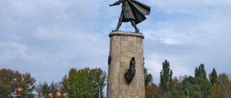
The famous journalist and brother of the great director Vladimir Nemirovich-Danchenko, Vasily, stayed here. At the invitation of Morozov, A.P. Chekhov also visited here. A bust of the writer was installed in Vsevolodo-Vilva.
The famous chemist, discoverer of the anesthetic chloroform B. Zbarsky began his scientific career at the local plant. Years later, he - one of the few - was allowed to embalm the body of V.I. Lenin.
Twenty-six-year-old Boris Pasternak lived and worked in this city for 6 months in 1915. The local nature, harsh climate and open Siberian people influenced the development of Pasternak as a writer and poet.
It was in these parts that he found his unique author's style. Many poems are dedicated to the local beauties, and they can be seen in his prose.
Additional information: in the city of Vsevolodo-Vilva on the street. Svoboda, house 49, the B. Pasternak house-museum has been opened, where literary evenings dedicated to the writer are regularly held.
Many city streets bear the names of famous personalities: Michurin, Timiryazev, Karl Marx, Pushkin, Gogol, Uritsky, etc.
Ivaka tract
Not far from Vsevolodo-Vilva there is an amazing and mysterious place that few tourists get to - Ivakinsk or the Ivaka tract.
Previously, the Ivakinsky woodworking plant, owned by Savva Morozov, flourished here. The company supplied wood for a nearby chemical production plant. A village formed around the plant, which developed until 1980, when the last residents left the area.
Now there is a vacant lot covered with grass, and the ruins of a factory, which attract with their mystery, and the Ivakinsky pond with a beach equipped for swimming.
Yaiva
The village of Yayva and the station of the same name on the Chusovskaya-Solikamsk railway line appeared in the 1930s as a place of residence for special settlers (dispossessed peasants).
The village became famous due to the thermal power station built in 1965 on the Yayva River - Yayvinskaya State District Power Plant.
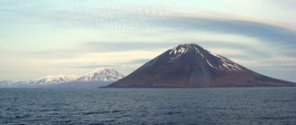
Attractions
Aleksandrovsk and its surroundings are a treasure trove of amazing natural attractions, including rocks, caves and lakes. Analogues of some of them cannot be found not only in the Perm region , but throughout the Urals . A trip here is a great opportunity to get acquainted with amazing objects and the history of your native region.
Alexander Pond
Aleksandrovsky , also known as Lytvensky Pond , was artificially created in 1805 during the construction of a dam to meet the needs of the plant. The report on the state of affairs at the railway plant said that “the pond will be very thick and not shallow in depth.”
Photo source: VALEKSE.RU
Its depth is truly impressive - if the average depth is about 6.5 meters, then the maximum exceeds 8 meters. And this is with a maximum latitude of 5 meters.
The history of the construction of the dam on the Alexander Pond is quite dramatic - it was built by several thousand serfs, some of whom died during construction: from hunger, disease and hard labor.
Photo source: VALEKSE.RU
Today the pond is used as a place for recreation, camp tourism and fishing - here you can catch perch, pike, bream, carp, ruff and many other fish.
GPS coordinates: 59.174292, 57.566998
Tract Quiet Stone
The Quiet Stone tract is a section of the Yaiva River with rocks forming the Rodnichny , Tikhy , Vyazovy and Sokoliny .
The height of the stones reaches 180 meters. In each of the stones you can find a cave - they store a lot of treasures - in the cave of the same name Spring Stone you can still find traces left by treasure hunters. However, most of these treasures are of scientific interest rather than material benefit.
Thus, cowrie shells from the Indian Ocean , part of a bone arrow and other archaeological finds Falcon Cave The caves contain paleozoological remains, such as the bones of Pleistocene animals.
Today, the Quiet Stone tract is a protected landscape of regional importance and is part of the large tourist ring of Alexandrovsk . Quiet Kamen is located 3 kilometers southeast of the village of Kamen .
Cave of Secrets
The cave, located in the valley of the Berezovaya River , received such an intriguing name for a reason - researchers found many interesting artifacts here.
Photo source: Alexandrovsky municipal district of Perm region
The cave begins to amaze from the very threshold - the height of its entrance arch reaches 10 meters, the width is 18 meters, and the length is about half a kilometer.
Initially, the Cave of Secrets was just an entrance grotto - the passage into the depths of the cave was blocked with cobblestones. However, in 1963 the stones were dismantled, opening a new part of the cave. Researchers have discovered here a huge number of bones of prehistoric animals - for example, the bones of a small cave bear that inhabited the Urals about 37 thousand years ago; a large cave bear (the Cave of Tyne is believed to have one of the most recent populations in the world). The cave became popularly known as the largest cemetery of cave bears.
The cave was also popular among ancient people - an ancient sacrificial fire pit, flint arrowheads and spears were discovered here, and researchers also believe that an ancient sanctuary was located in the cave.
GPS coordinates: 59.25462, 57.453358
Anyusha tract
The tract is located on the right bank of the Chanva River , 18 kilometers from Aleksandrovsk and is a complex natural monument of regional significance.
Previously, a camp for special settlers from the village of Anyusha . The tract is of greatest interest for its caves - there are more than twenty of them on its territory. The most famous is the cave of the Underground Hunters , which dates back to the 10th millennium BC. The Teplaya , Naklonnaya , and Drakonova Shchel , as well as the Black Bones and White Crypt are also popular .
Archaeological and paleozoological remains were found in the grottoes and caves - skulls and bones of brown bears, bones of a wild horse, woolly rhinoceros, mammoth, bison, as well as flint products from the Paleolithic era.
GPS coordinates: 59.303727, 57.825174
Cave Two-story building
The cave is located about two kilometers from Aleksandrovsk , not far from the village of Surya-3 . It got its name due to its unique structure - it actually has two floors. And because of the through passage it is also called Through .
Photo by: Yulia Sheikina
On the first floor of the cave there is a resting place for tourists - there is a table, benches and a fire pit.
The first finds in the Dvuhetazhke cave were made by E.P. Bliznetsov , who carried out exploratory excavations in 1967. On 30 square meters of the studied territory, scientists found elements of human life: fragments of dishes and a bone arrowhead, which were attributed to the Rodanian culture. Bliznetsov also found the bones of fossil “pets” of ancient people - horses, reindeer and rhinoceros.
GPS coordinates: 59.164, 57.5089
Babinovskaya road
The Babinovskaya road, or tract, is of great historical importance to researchers: many place it even higher than the Siberian tract , which was built as an improved replacement for the Babinovsky tract .
photo: valekse.ru
They built a highway with the goal of connecting the European part of the country with Siberia , namely with the Tobolsk region . Against this background, gradually the entire section of the transport line began to become overgrown with settlements, the main task of which was to maintain the highway and provide services to coachmen and other people passing through here.
Initially, the Babinovskaya Road was of great importance for the Russian state and was the first road to connect the two parts of the country. The road lost its prestige after the construction of a more modern and convenient location - the Siberian Highway .
Photo by: Dasha Antropova
Today, nothing remains of the ancient highway - everything is overgrown with weeds. However, researchers and historians still come here in the hope of discovering new artifacts.
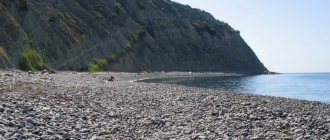
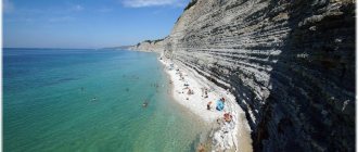
Blue Lakes
The lake got its name due to the sky-blue hue of the water, which tourists and photographers come from all over the Urals .
Photo by: Artem Nechaev
In fact, blue lakes are flooded limestone quarries opened about 300 years ago by the Stroganovs in the area between the Yaiva and Kosva for the extraction of brown ironstone. The pleasant color of the water is given by the high content of limestone and copper particles in it, so swimming here is not the best idea. Although this stops few people - here and there you can see tourist tents, and some even installed inflatable attractions right on the pond.
GPS coordinates: 59.182247, 57.490881
Gornozavodsky district
Gornozavodsky district neighbors Aleksandrovsky district. It is interesting because iron ore from local deposits was supplied to the Aleksandrovsk ironworks. There were also their own factories here: Bisersky, Pashiysky and Kusye-Alexandrovsky.
Ust-Koiva
At the mouth of the Koiva River, which is a tributary of the Chusovaya, there is the urban village of Ust-Koiva. This small town has many interesting sights that are of interest to inquisitive tourists.
Where the old dam was, there is now a vast waterfall, a picturesque suspension bridge connects the banks of the river, and the abandoned walls of an ancient factory attract mystery lovers. There is a small park and a local history museum here.
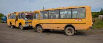
For thrill-seekers, rafting along the Chusovaya and Koiva rivers is organized from the village of Sloboda located upstream.
Aleksandrovsk, exact time
| Perm Airport 166 km Russia PEE |
| Chelyabinsk International Airport 488 km Russia CEK |
| Roshchino Airport 503 km Russia TJM |
| Ufa International Airport 522 km Russia UFA |
| Ukhta Airport 531 km Russia UCT |
Time in the world Information Aleksandrovsk, Perm region, location on the map, Russia . This geographical object is located in the Ekaterinburg time zone, standard time (UTC +5), coordinates - 59.15623280000001, 57.5942158. The approximate population is 15.5 thousand people. According to our data, Russia is a country where the official currency is the Russian Ruble (RUB). We counted the number of streets for Alexandrovsk, this number is 105. The distance to the capital (in a straight line) is 1,248 km (Alexandrovsk - Moscow). Streets that are most often found in addresses: st. Lenina, st. Kim, st. Mekhonoshina, Elektrovozny lane, st. Khalturina, st. Kirova, Kuznechny lane, st. Zhdanova, st. Chernyshevsky, Yubileinaya st.. View the full list of streets - Aleksandrovsk.
| London, Great Britain | 10 September 04:32 |
| Los Angeles United States of America | 09 September 20:32 |
| Paris, France | 10 September 05:32 |
| Moscow, Russia | 10 September 06:32 |
| Dubai United Arab Emirates | 10 September 07:32 |
| New York United States of America | 09 September 23:32 |
| Beijing, China | 10 September 11:32 |
| Shanghai China | 10 September 11:32 |
| Antalya Türkiye | 10 September 06:32 |
| Mumbai India | 10 September 09:02 |
| Nishitokyo Japan | 10 September 12:32 |
| Berlin, Germany | 10 September 05:32 |
| Berezniki Perm region, Russia 54 km |
| Solikamsk Perm region, Russia 74 km |
| Perm Perm region, Russia 147 km |
| Serov Sverdlovsk region, Russia 179 km |
| Glazov Republic of Udmurtia, Russia 307 km |
| Ekaterinburg Sverdlovsk region, Russia 313 km |
| Votkinsk Republic of Udmurtia, Russia 317 km |
| Asbestos Sverdlovsk region, Russia 330 km |
| Izhevsk Republic of Udmurtia, Russia 362 km |
| Sarapul Republic of Udmurtia, Russia 376 km |
| Neftekamsk Republic of Bashkortostan, Russia 393 km |
| Ozersk Chelyabinsk region, Russia 426 km |
| Kirovo-Chepetsk Kirov region, Russia 439 km |
| Ufa Republic of Bashkortostan, Russia 501 km |
| Chelyabinsk Chelyabinsk region, Russia 501 km |
| Tyumen Tyumen region, Russia 515 km |
| Kazan Republic of Tatarstan, Russia 629 km |
| Ulyanovsk Ulyanovsk region, Russia 777 km |
| Samara Samara region, Russia 800 km |
| Orenburg Orenburg region, Russia 837 km |
| Yaroslavl Yaroslavl region, Russia 1,043 km |
| Omsk Omsk region, Russia 1,055 km |
| Moscow Russia 1,248 km |
| Lipetsk Lipetsk region, Russia 1,331 km |
| Volgograd Volgograd region, Russia 1,438 km |
| Warsaw Masovian Voivodeship, Poland 2,384 km |
| Helsinki Finland 1,819 km |
| Oslo Oslo, Norway 2,588 km |
| Riga Latvia 1,965 km |
| Tbilisi Tbilisi, Georgia 2,132 km |
| Tallinn Harju County, Estonia 1,846 km |
| Astana Akmola region, Kazakhstan 1,248 km |
| Beijing Beijing, China 4,563 km |
| Seoul South Korea 5,361 km |
| Kyiv Ukraine 1,968 km |
Flights Select a calculator: Currency calculator, currency exchange rates Distance calculator Weather in cities by month Date calculator Random number generator Password generator Technical characteristics of cars Fuel consumption calculator Calculator of units of measurement of physical quantities Select another language: Čeština Dansk Deutsch English Español Français Italiano Nederlands Norsk Polski Português Suomalainen Tiếng Việt Türk Български Russian العربية ไทย 日本人 © 2022 Needcalc.com Needcalc.com Privacy Policy Terms of Use Contacts This page was created in: 0.0858 sec. Select language čeština dansk Deutsch English español français italiano Nederlands norsk polski português suomalainen tiếng Việt Türk Български Russian العربية ไทย 日本人 Cancel
Economy
In Aleksandrovsk there are also widely developed enterprises for primary timber processing - sawmills.
In the 1990s, unlike the mining towns and villages of the Kizelovsky coal basin, Aleksandrovsk avoided the loss of city-forming enterprises and acute industrial depression. However, the city is experiencing problems typical of all old industrial cities of the Urals.
By Order of the Government of the Russian Federation dated July 29, 2014 N 1398-r (as amended on May 13, 2016) “On approval of the list of single-industry towns”, included in the list of single-industry towns of the Russian Federation with the risk of worsening the socio-economic situation
. [25]
Features of reservoirs
The Blue Lakes of Alexandrovsk include several flooded old quarries where limestone was once mined. Its deposits were formed hundreds of millions of years ago, when this territory was flooded by an ancient sea. Its existence is reminiscent of characteristic imprints visible to the naked eye on chips of sedimentary rock.
Stepped ledges of a quarry, © Konstantin Efremov
The two Blue Lakes are considered the most attractive for recreation:
- Shavrinskoe - length 800 m, width 230 m, depth 70–72 m;
- Morozovskoe - length about 1.4 km, width 150 m, depth almost 40 m.
The lake shores have stepped ledges characteristic of quarries. Their slopes are partially covered with vegetation. At the very top there is a mixed forest, inhabited by birds and small animals.
The unusual turquoise-blue color of the lake water is associated with the presence of small particles of copper and limestone in its composition.
Alexandrovsk (Perm region)
| City | |
| Alexandrovsk | |
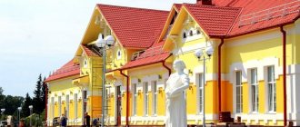
| City administration building | |
| 59°10′00″ n. w. 57°35′00″ E. d. HG I OL | |
| A country | Russia |
| Status | marginal value |
| Subject of the federation | Perm region |
| Municipal district | Alexandrovsky |
| History and geography | |
| Based | 1783 |
| City with | 1951 |
| Center height | 180 m |
| Timezone | UTC+5:00 |
| Population | |
| Population | ↘ 11,739 [1] people (2022) |
| Population of the agglomeration | 34.6 thousand |
| Katoykonim | Aleksandrovtsy, Aleksandrovets |
| Digital IDs | |
| Telephone code | +7 34274 |
| Postcode | 618320, 618323 |
| OKATO code | 57405 |
| OKTMO code | 57502000001 |
| The population of the city is 11,739 [1] people. (2021). The city is located on the western slope of the Middle Urals, on the Lytva River (Kama basin), 150 km northeast of Perm. Aleksandrovsk has a temperate continental climate. The warmest month is July, with an average temperature of +17.2 °C. The coldest month is January, with an average temperature of −16.2 °C. The average annual precipitation is 635 mm. The least precipitation falls in February, with an average of 29 mm, and the most in July, with an average of 93 mm. | |
Site search
Our Telegram group for exchanging ideas, projects, thoughts, people in the IT field of Rostov-on-Don: @it_rostov Name of locality (city): Aleksandrovsk
International name:
Aleksandrovsk
Size of settlement:
Village/stanitsa/hamlet with a population of less than 15 thousand people
District (district):