Author: Svetlana Kusha (kusha69).
The famous plant breeder Michurin called the city of Korocha the second Crimea.
My childhood friends from Kamchatka live there. They found me through the Internet.
Haven't seen each other for twenty years. We talked on the phone, but you can’t tell everything, you won’t remember...
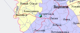
Korocha on the map of Russia
You can find Korocha on the map and get directions using your navigator using the coordinates (50.872231, 37.303198). In the northwest is Kursk, in the northeast is Stary Oskol, in the east is Novy Oskol, in the southwest is Belgorod, in the west is Stroitel, in the south, 45 kilometers away is the border with Ukraine. Near the city are the villages of Bekhteevka, Kazanka, Pogorelovka, Podkopaevka, Pushkarnoe and Belogorye, as well as the Pogorely farm.
In short - the second Crimea
The guys definitely asked to tell us: the name of the city comes from the Tatar-Mongolian word “black mud”. The Tatar-Mongols went to conquer these places either in the fall or in the spring, in general, after the rains. Their horses were so stuck in the ground that they could not move from fatigue. And no one went further. And they called this place Karacha. The name remained the same, only changed in the Russian way - Korocha.
As the guys said, the Korochansky district is famous for apples. Michurin really liked the Black Earth Region; the fertile lands inspired him to breed apples. Further along the road are apple orchards, where new varieties are still being developed. But we didn’t go there, but returned to the city.
To the park named after Guy G.D.
Military Glory Park.
Very beautiful, clean, well maintained.
The eternal flame burns. The guys said it never goes out - it burns day and night, in any weather and season.
Lists of heroes.
The former Korochansky women's gymnasium was built in 1908, now the Korochansky secondary school named after D.K. Kromsky. located across the street from the park. A most beautiful building.
The guys said that it stood scary and shabby for a long time, and then it was restored, and the building became a beauty and a calling card of the city.
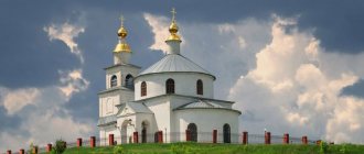
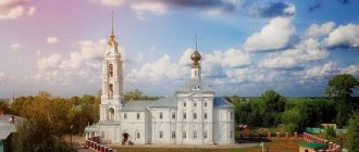
Further along the way there was a church.
For some reason, the blue color of the temple seemed unusual to me; I had never seen blue churches before. But, after searching for information, I found out that the Church of the Virgin Mary is often painted blue.
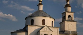
A tree grows on the roof of the church.
There are small images on the side and on the façade.
How to get there
- By car from Moscow you need to take the toll highway M-4 “Don” or the free highway M-2 “Crimea”. Travel time will be about 9 hours.
- By bus from Moscow in 9-10 hours.
- You need to go by train to Belgorod. On the route St. Petersburg → Moscow → Belgorod , by trains: No. 081A, 119A, 741A, 078B . Then get to the Belgorod bus station by trolleybus No. 1,4,13, by bus No. 112 or by minibus No. 25, 213, 28,130 and take the bus to Korocha.
- By plane Moscow → Belgorod from airports: Domodedovo, Vnukovo and Sheremetyevo. Then walk 300 meters to the bus stop, take any bus to the Belgorod bus station, and then take the bus to Korocha.
Royal letters.
In 1859, the Moscow University Printing House published a separate book, “Tsar’s Letters to the Korocha Governors and Petitions to the Korocha Tsars,” reported by F. Zaitsev. The background to this book is this. In 1837, F. Zaitsev, a competitor of the Imperial Society of Russian History and Antiquities, informed the society about ancient letters stored in the chest of the Korochansky district court, and asked the society to receive
permission from the Ministry of Justice to transfer them for study. Chairman of the society S.G. Stroganov addressed this issue to the Minister of Justice, on whose instructions the director of the Moscow Archive of the Ministry of Justice P.I. Ivanov compiled a “General overview of documents” and “Inventory of documents forwarded to the archive from the Korochansky district court in 37 bundles.” The royal letters contain extensive information, incl. and warnings about surprise attacks by enemies on Korocha.
From the “review” it follows that the documents cover the period of time from 1642 to 1709 and relate to the reign of Mikhail Fedorovich, Alexei Mikhailovich; John and Peter Alekseevich.
Attractions
The “messenger” bell is a gift from Tsar Alexei Mikhailovich to the city of Koroshe after its founding. The bell was placed under a canopy and served to notify residents. Free access to the bell led to the fact that after some time it was broken due to inept handling. Then in 1674 the tsar gave a new one, which has survived to this day.
The Church of the Nativity of the Blessed Virgin Mary is the third temple in a row. At first there was a wooden church on this site - the same age as the city of Korocha. The church burned down due to a lightning strike. The second temple was made of stone. Over time, it was dismantled and in 1876 a third temple was built, which has survived to this day.
Korochansky Museum of History and Local Lore was founded in 1994. Located in an ancient building from the late 19th century. Currently, the museum's collection consists of more than five thousand exhibits, which are presented in three exhibition halls.
The Yasny Well spring is a source of mineral water. Located within the city in the floodplain of the Korocha River. The spring has been known since the time of the Tatar-Mongol invasion. On the landscaped territory of the holy spring there is a chapel, a font and other infrastructure facilities.
Monument to the founder of the city of Korocha, governor Andrei Vasilyevich Buturlin. The composition was opened on the central square in 2013 on City Day. The monument was created from bronze and copper, on a granite pedestal by sculptor Dmitry Fedorovich Gorin.
The geoglyph “70 Years of Victory” is a natural monument founded in 2015, three hundred meters from the village of Pogorelovka, Karachansky district, representing a giant inscription made of 10 thousand pine trees. Size of numbers: height – 70 m, width – 35 m, distance between numbers – 10 m. Size of letters: height – 30 m, width – 22.5 m, distance between letters – 7.5 m, distance between lines - 10 m. The inscription can be clearly seen from a bird's eye view.
In short, we’re going to Korocha!
And then they call me and tell me: they changed the phone number so that it would be cheaper for me to call them, and I spontaneously have a desire to go visit them in Korocha. It often happens to me - I wanted to, so I have to go, but you put it off until “later” - it will never work out. We need it right away!
We left in the afternoon - around four o'clock. Eight hours later, having traveled 640 kilometers, we were in Koroche!
After dinner, talking a little, resting, in the morning, that is, at about 12 o’clock, we went to see the city and the immediate surroundings.
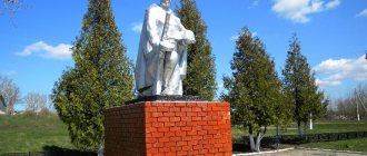
The first stop is Pobediteley Park in the nearest village of Pogorelovka (well, the closest one is two meters from Korocha: the signs on the road were at that distance).
This is a historical monument - a mass grave of Soviet soldiers who died in battles with the fascist invaders. Protected by the state.
We played with a little black kitten.
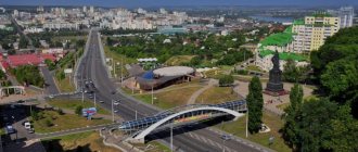
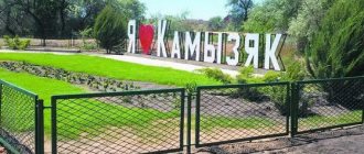
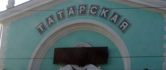
And we went to the very outskirts, to the famous entrance to the city.
Links[edit]
- ^ abcd Resolution No. P/21-21-4
- ^ B “Mojgorod encyclopedia. Entrance to Korocha" (in Russian). Retrieved October 2, 2013.
- ^ a b Federal State Statistics Service (2011). “All-Russian Population Census 2010. Volume 1" [All-Russian Population Census 2010, vol. 1]. All-Russian Population Census 2010 [All-Russian Population Census 2010]
. Federal State Statistics Service. - "26. The size of the permanent population of the Russian Federation by municipalities as of January 1, 2022". Federal State Statistics Service. Retrieved January 23, 2022.
- State Committee of the Russian Federation on Statistics. Committee of the Russian Federation for Standardization, Metrology and Certification. No. OK 019-95 January 1, 1997 “All-Russian classifier of objects of administrative-territorial division. Code 14 240", ed. changes No. 278 / 2015 dated January 1, 2016. (Goskomstat of the Russian Federation. Committee of the Russian Federation for Standardization, Metrology and Certification. No. OK 019-95 January 1, 1997. Russian classification of administrative divisions) (OKATO).
Code 14 240 , as amended by Amendment No. 278/2015 of 01/01/2016). - ^ abcde Law No. 159
- "On the Calculation of Time". Official Internet portal of legal information
. June 3, 2011. Retrieved January 19, 2022. - Post office. Information and computing center of OASU RPO. ( Post office
).
Search for postal service objects ( postal Search for objects
) (in Russian) - ↑
Federal State Statistics Service of Russia (May 21, 2004).
“The population of Russia, the constituent entities of the Russian Federation as part of federal districts, urban settlements, settlements, settlements is 3 thousand or more people” [Population of Russia, its federal districts, federal districts, districts Urban settlements, rural settlements - administrative centers and rural settlements with a population of over 3,000] (XLS). All-Russian Population Census 2002
. - “All-Union Population Census of 1989. The current population of union and autonomous republics, autonomous regions and districts, territories, negative phenomena, urban settlements and rural district centers” [All-Union Population Census of 1989: current population of union and autonomous republics, Autonomous regions and districts , territories, regions, districts, urban settlements and villages performing the functions of district administrative centers. All-Union Population Census of 1989 [All-Union Population Census of 1989]
.
Institute of Demography of the National Research University: Higher School of Economics [Institute of Demography of the National Research University: Higher School of Economics]. 1989 - via Demoscope Weekly
.
Sources [edit]
- Belgorod Regional Duma. Resolution No. P / 21-21-4 of November 8, 2007 “On the lists of settlements in the Belgorod region,” as amended. Resolution No. P / 47-25-5 of May 28, 2015 “On amendments to the Resolution of the Belgorod Regional Duma of November 8, 2007 No. P / 21-21-4 “On the lists of settlements in the Belgorod region” ". Published: “Collection of normative legal acts of the Belgorod region”, No. 116, 2007 (Belgorod Regional Duma. Resolution No. P / 21-21-4 of November 8, 2007 “ On registers of settlements in the Belgorod region”
as amended by the resolution No. P / 47-25-5 dated May 28, 2015 “
On amendments”).
Resolution of the Belgorod Regional Duma of November 8, 2007 No. P / 21-21-4 “On registers of settlements in the Belgorod region” . - Belgorod Regional Duma. Law No. 159 of December 20, 2004 “On establishing the boundaries of municipalities and granting them the status of an urban, rural settlement, urban district, municipal district,” as amended. Law No. 244 of December 4, 2013 “On the amendment to Article 12 of the Law of the Belgorod Region” On establishing the boundaries of municipalities and granting them the status of an urban, rural settlement, urban district, municipal district “”. Came into force after 10 days from the date of official publication. Published: “Belgorod News”, No. 218–220, December 24, 2004 (Belgorod Regional Duma. Law of December 20, 2004 No. 159 “ On establishing the boundaries of municipalities and granting them the status of an urban, rural settlement, urban district, municipal district").
As amended by Law No. 244 of December 4, 2013 “
On amendments to Article 12 of the Law of the Belgorod Region “On establishing the boundaries of municipalities and granting them the status of an urban, rural settlement, urban district, municipal district
. Valid from the day that occurs 10 days after official publication.).
History[edit]
What is now called Korocha has been known since 1638 as a small Russian fortress [2], built as part of a line of defense between modern Belgorod, Tambov and Ulyanovsk against the Crimean Tatars. At that time it was the southern border of the Russian Empire. It was originally called the Red City in Koroche
, later abbreviated as Korocha.
[ citation needed
] It was granted city status in 1708.
[ citation needed
] Until the beginning of the 20th century, Korocha remained the main city in the region, but then lost its importance. During World War II, Korocha was occupied by the German Wehrmacht on July 1, 1942 and liberated on February 7, 1943 on the Voronezh Front by the Red Army during the Third Battle of Kharkov.
County town.
In 1708, all of Russia was divided into 8 provinces, and Korocha, along with other 56 cities, was assigned to the Kyiv province. In 1719, when the provinces were divided into provinces, Korocha was part of the Belgorod province of the Kyiv province. Our city existed as a guard and defensive point until the last quarter of the 18th century. On May 23, 1779, the city of Korocha became a district town of the Kursk governorship. On January 8, 1780, Empress Catherine II approved the coat of arms of the city of Korochi - a distinctive sign of the city, consisting of two parts. In the upper part there is the coat of arms of the provincial Kursk with three flying partridges, and in the lower part there are three apples on a silver field. The author of the coats of arms of the district cities of the Kursk governorship was the King of Arms Volkov. In 1802-1924, Korochansky district, along with Belgorod, Grayvoronsky, Novooskolsky and Starooskolsky districts, was one of the 15 districts of the Kursk province.
The State Archives of the Kursk Region contains a copy of the plan of the city of Korocha in 1784, made by the Grayvoron land surveyor Krasnov. The plan notes: two shopping areas, a cathedral and two parish churches, the city hall, the ecclesiastical board and school, a public school, the city infirmary, an almshouse, drinking houses, trading shops and taverns, a prison and guardhouses. The plan shows the planned buildings: salt shops, public places, postal yard, meat and fish stalls, brewery, slaughterhouse, etc.
Plan of the city of Korocha and its southwestern environs. Beginning the 18th century
The city limits are limited by the following streets: Verkhnyaya, Srednyaya, Dvoryanskaya, Veselaya, Kharkovskaya, Podyacheskaya, Embankment along the Korocha River (longitudinal); Krasnogorskaya, Nikolaevskaya, Rozhdestvenskaya, Kurskaya, Pokrovskaya, Kuzubovskaya (transverse). A large road from Kursk to Novy Oskol runs through the entire city.
Let us turn to the “Description of Kursk Governorship”, compiled in 1784 by its ruler Afanasy Nikolaevich Zubov. The city of Korocha lies at the foot of a mountain, which is “planted” with gardens. In 1780, the following were opened in Koroch: government offices, mayor government, district and lower zemstvo courts, noble guardianship and lower reprisal. State-owned buildings include: house for the mayor - 1; district court, solicitor's office, lower zemstvo court and noble guardianship - 1, lower reprisal - 1, exit for the treasury - 1, archive for letters - 1, storeroom barn - 1, bathhouse - 1, cellar for artillery supplies - 1, drinking house - 1, salt barn - 4, prison hut - 1, stable - 1. Common houses: noble - 6, merchants - 2, clergy - 24, raznochinsky - 64, merchant wooden stamps - 19, tavern - 1, tavern - 1 In Koroche there were 6 churches (5 of them wooden).
In Koroche there were 6 fairs: September 8 - Christmas-Bogoroditskaya, December 6 - Nikolaevskaya, January 1 - Vasilievskaya, May 9 - Nikolaevskaya, July 8 and August 15 - Uspenskaya. They last no more than two days. The merchants and townspeople traded in small red goods, and the townsfolk traded in bread, which they also exported for sale to the Kharkov governorship and Orel. Among the artisans: 29 tailors, 16 blacksmiths, 17 shoemakers, 17 carpenters, 1 carpenter, 25 weavers, 7 tanners, 14 sheepskin workers, 7 coopers and 9 wheelwrights. Pine and oak timber for construction was imported from the Voronezh province.
In the settlement of Bekhteevka there were two wooden churches - in the name of the Kazan Mother of God and in the name of the Sign of the Blessed Virgin Mary. Among the landowners, we note Lieutenant Ivan Ionin, who had his own house and two mills on the Korocha River. Sloboda Ivitsa belonged to Lieutenant Colonel Nastasya Vasilievna Merlina, who had a stone house, a brick factory, 2 horse factories, 4 shops, a bread store, a forge, a mill on the Ivica River “with two flour warehouses and seven millet mortars.” In the village of Nechaevo there were 2 landowner houses - second lieutenant Pyotr Mikhailovich Ilyinsky and ensign Alexander Nikitovich Avdeev.