For other places with the same name, see Makarov.
City in Sakhalin Oblast, Russia
| Makarov Makarov | |
| City [1] | |
| Coat of arms | |
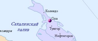
| Location of Makarov | |
| Makarov Location of Makarov Show map of Russia Makarov Makarov (Sakhalin region) Show map of Sakhalin region | |
| Coordinates: 48°38'N 142°48'E / 48.633°N W. 142.800° E. / 48.633; 142.800 Coordinates: 48°38'N 142°48'E. / 48.633 ° N W. 142.800° E. / 48.633; 142,800 | |
| A country | Russia |
| Federal subject | Sakhalin region [1] |
| Administrative region | Makarovsky district [1] |
| Based | 1892 |
| City status from | 1946 |
| Height | 20 m (70 ft) |
| Population (2010 Census) [2] | |
| • General | 6 705 |
| • Evaluate (2018) [3] | 6 567 ( -2,1% ) |
| Administrative status | |
| • Capital from | Makarovsky district [1] |
| Municipal status | |
| • Urban district | Makarovsky urban district [4] |
| • Capital from | Makarovsky urban district [4] |
| Timezone | UTC+11 (MSK+8[5]) |
| Postal code [6] | 694140 |
| Dialing code(s) | +7 42443 [7] |
| OKTMO ID | 64724000001 |
Makarov
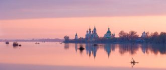
(Russian: Makarov) is a coastal town and administrative center in Makarovsky District in Sakhalin Oblast, Russia, located on the east coast of Sakhalin Island, 235 km (146 mi) north of Yuzhno-Sakhalinsk. Population: 6,705 (2010 census); [2] 7,271 (2002 census); [8] 11,351 people (1989 census). [9]
Links[edit]
Notes[edit]
- ^ abcde Law No. 25-ZO
- ^ a b Federal State Statistics Service (2011). All-Russian Population Census 2010. Volume 1 [All-Russian Population Census 2010, vol. 1]. All-Russian Population Census 2010 [All-Russian Population Census 2010] (in Russian). Federal State Statistics Service.
- "26. The size of the permanent population of the Russian Federation by municipalities as of January 1, 2022". Federal State Statistics Service. Retrieved January 23, 2022.
- ^ abc Law No. 524
- "On the Calculation of Time". Official Internet portal of legal information
. June 3, 2011. Retrieved January 19, 2022. - Post office. Information and computing center of OASU RPO. ( Post office
).
Search for postal service objects ( postal Search for objects
) (in Russian) - Telephone codes of Sakhalin - Telephone codes of Sakhalin (in Russian)
- ↑
Federal State Statistics Service of Russia (May 21, 2004). The population of the Russian Federation, cities of the Russian Federation as part of federal districts, urban settlements, settlements, settlements, settlements is 3 thousand or more people. [Population of Russia, its federal districts , subjects of the Federation, districts, urban settlements, rural settlements - administrative centers and rural settlements with a population of more than 3000 people] (XLS). All-Russian Population Census of 2002 [All-Russian Population Census of 2002] (in Russian). - All-Union Population Census of 1989 Population of Union and Autonomous Republics, Autonomous Regions and Districts, Territories, Regions, Urban Settlements and Village District Centers [All-Union Population Census of 1989: Current Population of Union and Autonomous Republics, Autonomous Regions and Districts, Territories, Regions , districts, urban settlements and villages performing the functions of district administrative centers]. All-Union Population Census of 1989 [All-Union Population Census of 1989] (in Russian). Institute of Demography of the National Research University: Higher School of Economics [Institute of Demography of the National Research University: Higher School of Economics]. 1989 - via Demoscope Weekly
.
Russian Bath Kholmsk
Traces of the presence of ancient man on the territory of the modern Makarovsky region date back to the Stone Age - finds of stone tools and remains of ancient ceramics at the Pugachevsky sites and the river. Markovka (Paleolithic era).
One of the very first settlements of “modern” man in the region arose on the site of the Makunkotan camp (the village of Pugachevo). Here already by the eighties of the XIX century. There were two Japanese and one Russian fishing grounds, and there were convenient lands for arable farming. Then the Ainu began to choose places for more northern settlements. This is how the village of Venkotan appeared, next to which in an unflooded zone there was a small camp of Selutora (Makarov), which translated from Ainu meant “dry village” (“selyu” - dry, “tora” - a village in which at least three families in different yurts at the same time).
In 1890-1900 A postal route ran through the territory of the district from the Korsakovsky post to the Aleksandrovsky post. They transported mail to Nayoro (Gastello village, Poronaisky district), where they exchanged it for mail that came from the north. Near the Selutora camp in 1892, on the site of a temporary hut where postal sledges were changed, a telegraph machine appeared. Major Stender was appointed head of the work on the Selyutor machine tool. To help him, four soldiers, one sailor and three exiled settlers were assigned. The Central State Archive of the Far East (Vladivostok) preserves the “Report on the farms of exiled settlers of the Korsakov District who were on government pay,” which lists two names of three exiled settlers - Vasily Kotik and Dmitry Suvorov.
By the end of 1892, thanks to Stender’s complaints that the groups sent to build telegraph supports and improve the machine itself were constantly distracted by their superiors for any other work, they sent a whole detachment of exiled convicts, who became permanent residents here.
So 1892, when the construction of the telegraph machine began, and some small group of people began to live permanently in Selutor, can be considered the year of the founding of the city of Makarov.
In 1905, as a result of Russia's defeat in the Russo-Japanese War of 1904-05. The southern part of Sakhalin went to Japan. The period of the most intensive use of the area’s natural resources begins, among which forest and fish were in the first place, the construction of settlements (more than forty), and the agricultural, industrial and cultural development of the area. In Shiritori (as the Japanese called Selutora), the Japanese built a paper mill, mines, a pier, a sulfite-alcohol plant, a printing house, a water supply system, two agricultural farms (Porechye, Travyanaya), two cinemas and two theaters, a Shinto and other temples, a middle-level industrial school , where they trained specialists for the paper industry, and other enterprises. A railway was built through Siritori from the town of Otiaya (Dolinsk) to the town of Sikuki (Poronaisk).
In 1945, the ancestral Russian lands were returned to Russia. Japanese residents were repatriated to their homeland, their property was nationalized. To develop and boost the national economy, from May 15, 1946, a large flow of immigrants poured into Sakhalin, including the Makarovsky region. Mass renaming of settlements began. The new names were based on the names of the fighters for the establishment of Soviet power on Sakhalin - Art. Tsapko (in honor of the chairman of the Sakhalin Revolutionary Committee A.T. Tsapko, tortured by the Japanese), heroes of Russian history - p. Pugachevo (in memory of the leader of the Peasant War of 1773-1775, Don Cossack E.I. Pugachev). Other names were given simply according to the geographical location of the settlement (Vostochny, Gornoye, Zaozernoye, Porechye, Lesnoye, Elovoe, Verkhovye, etc.) or according to its climatic conditions (Tumanovo station).
By decree of the Presidium of the Supreme Council of the RSFSR on June 5, 1946, the city of Siritori was renamed the city of Makarov in memory of Admiral S.O. Makarov. The name of Stepan Osipovich Makarov appeared on the map of Sakhalin not by chance.
According to the documents stored in the regional archive, it is clear that in 1896-98. S.O Makarov was in Sakhalin on the cruiser “Kornilov”. During these years, he was engaged in laying a beam from Vladivostok to the Korsakovsky post. Entry from 1896 states that S.O. Makarov visited the governor’s house, visited the Japanese consul, visited the prison, came on “fishing trips” and was interested in the life of the settlers. The name of the city is not only a memory of the admiral who died during the Russo-Japanese War, but also as an assessment of his human and business qualities.
On June 5, 1946, 14 districts were formed on the territory of the South Sakhalin region, including Makarovsky with its center in the city of Makarov. The territory of the Makarovsky district is 2148.4 square meters. km., is located on the eastern coast of the southern part of Sakhalin Island and is washed by the waters of Terpeniya Bay in the Sea of Okhotsk. In the south, the region borders with the Dolinsky district, in the west - along the tops of the West Sakhalin ridge - with the Uglegorsky and Tomarinsky districts, in the north - with the Poronaisky district.
From September 1945 to March 1947, state power in the region was exercised by the district department for civil affairs, headed by chief A.A. Zolin. The civil affairs departments of the city of Makarov, the villages of Vostochny, Gorny and Ugledarsk were subordinate to the district administration. In 1947, on the territory of the Makarovsky district, the working village of Vostochny and rural Soviets were formed: Gorny (Gorny village, Markovo station, Tumanovo station), Pugachevsky (Pugachevo village, Poyasok station, Tikhaya station, Tsapko station, Art. Travyanaya), Ugledarsky (village Ugledarsk) and Novsky (village Novoe). The Porechensky Village Council appeared only in 1963. It included settlements - the village. Poreche, village Lazo, Art. Grebenskaya, st. Zaozernaya and Ugledarsk village.
In December 1947, the first elections to local councils were held in the region, the Makarovsky district and city councils were elected. The councils and their executive committees solved the priority tasks of economic and social development. Housing was built to receive immigrants from the mainland, schools, a hospital, and cultural institutions were opened, the work of local industrial enterprises was established (the Sovetsky Sakhalin food production plant, five fishing collective farms, a fish processing plant (Makarov) and a fish factory (Vostochny village)). Stable labor collectives were being formed at a paper mill, three mines, and a timber industry enterprise. In 1949, the Makarovsky state farm was organized.
Housing construction was underway in the area. By the end of the 40s, 800 log houses of the Russian type were built. In 1950, there were 27 schools, 18 medical institutions, 9 clubs, 33 libraries and reading rooms in the area.
In the 60-80s, work continued on the further development of the economy and social sphere. Intensive housing construction was underway, dilapidated Japanese barracks, heated by iron stoves, gradually disappeared. In their place, stone multi-storey comfortable housing grew. The city was transforming.
Industrial enterprises operated steadily: a pulp and paper plant, a food processing plant, a meat and dairy plant, a bakery plant, and the Makarovsky state farm. The main city-forming enterprises were Makarovsky pulp and paper.
In the 90s, the economy of the Makarovsky region underwent enormous changes. As a result of the worsening economic situation in the country, financial problems, and the protracted energy crisis, almost all industrial enterprises in the region found themselves on the verge of bankruptcy. Unable to withstand competition in the new economic conditions, in 1999 the Makarovsky Pulp and Paper Plant was closed for conservation. Due to unprofitability, the Makarovskaya mine was liquidated in April 2000.
As of January 1, 2010, 8.8 thousand people lived in the district, including 6.7 thousand people in the city of Makarov. The municipal formation "Makarovsky urban district" includes the city of Makarov and 10 villages: the village. Vostochnoe, s. Tsapko, s. Pugachevo, s. Quiet, s. Poreche, village Grebenskoye, village Zaozernoye, village Gornoe, village Tumanovo, s. New.
Currently, the main sectors of the region's economy are: fishing, food (production of canned fish, fresh-frozen fish and seafood, bread, bakery and confectionery products), mining of non-metallic building materials, and agriculture. In the area there are 000 "Rybak", 000 "Victoria", 000 "Turovka" (Novoe village), CJSC "Pugachevsky Fish Hatchery" (pugachevo village), LLC "RPP "Makarovskoe", LLC "Avtomobilist", LLC "Universal" -, MUP "Stroitel", Makarovsky branch (DSZ) of LLC "Trud-Sakhalin" (Village of Zaozernoe), State Unitary Enterprise "DRSU Makarovskoye" (Village of Porechye) and other enterprises.
The network of medical institutions consists of one district hospital, four paramedic and obstetric stations, a city clinic, and an emergency medical service station.
In the area there are two kindergartens, 6 schools, a children's art school, a children's and youth sports school, an evening (shift) school, a youth sports club, a branch of the Yuzhno-Sakhalinsk Industrial and Economic College and the Yuzhno-Sakhalinsk branch of the modern humanitarian academy.
The network of cultural and educational institutions is represented by the Center for Art, Culture and Leisure (which includes a district house of culture, a local history museum and three rural clubs) and the municipal institution “Makarovsk Centralized Library System” (which consists of a central, children's libraries and 4 rural libraries - branches). Since 1993, there have been two churches in Makarov - Orthodox and Presbyterian.
In recent years, many residents have left this corner of Sakhalin land, but they certainly return here in thought or reality. They return for the cold rains, June fogs, rare red berries, fish and caviar... They also return because they cannot erase from their memory the smell of the sea and the sound of the surf, grass as tall as a man and chamomile meadows, that unique beauty of nature that attracts forever .
Makarov residents expressed their love for their hometown, the memory of its past and hopes for its future in a memorial stele made from a monolith from the Ugledar deposit and installed on the station square of the city for its 100th anniversary. The inscription on the stele reads: “1892-1992. Selutora-Siritori-Makarov. Eternal memory to those who lived, love and kindness to those who live.”
Makarov
(Sakhalin region)
OKATO code:
64224501
Founded:
1892
City since:
1946 City of regional subordination
Center:
Makarovsky district
The city was formerly called:
| Selutora | 1905 | |
| Siritoru | 1905 | 1946 |
| Telephone code (reference phone) | |
| 42443***** | — |
| 424434**** | — |
Deviation from Moscow time, hours:
8
Geographic latitude:
48°37′
Geographic longitude:
142°47′
Altitude above sea level, meters:
20 Sunrise and sunset times in the city of Makarov