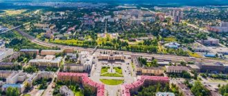
Hello, dear subscribers and guests of my online diary! In this note, I want to tell you about the city of Usinsk in the Komi Republic, in which I have lived for more than forty years, and all these years I have been a direct participant in its existence.
I will briefly introduce you to the main attractions of our young, small northern town, which at one time became a real forefront in the development of oil fields in the Komi Republic.
In this article you will learn about the streets of the city of Usinsk, what significant buildings are located on them. About its multinational population, about where and how residents spend their leisure time, what places they visit most often and why they are their favorites.
Also, my article will help numerous shift workers passing through our hospitable city to their workers’ settlements to freely navigate its streets and easily find objects of interest to them. Well, let's start our little excursion.
Location of the city of Usinsk on the map of Russia in the Komi Republic
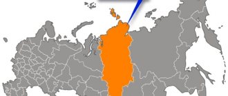
On the map of Russia, Usinsk is located in a part of the country that belongs to the European continent. Its location is considered to be in the far north. As for the administrative-territorial position, it is located in the Komi Republic, at its northern border.
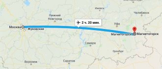
The distance to the capital of the autonomous republic – Syktyvkar – is 757 km in the south-west direction. A city district of the same name was formed around Usinsk, the central settlement of which was the city.
Memorial stone
This monument symbolizes the unity of all peoples living in one common territory. In 1985, its creators dedicated it to their future generation.
The inscription on the stone tells them how important tolerance and respect for one's neighbors can sometimes be, and also reminds them that Usinsk is an oil city that must maintain its level. Everyone who comes to this place begins to think about their actions and after that tries to make themselves and their surroundings a little better than before.
Climate and weather by month
Usinsk on the map of Russia is located on the border of the continental and subarctic climate zones. The climate of the settlement belongs to the Dfb category (humid continental climate with warm summers) according to the Köppen classification. It is very harsh, has many features and characteristics characteristic of the subarctic climate zone.
There is snow on the streets approximately 230 days a year - it falls in mid-October and disappears only by June. Winter here is long and harsh, summer is short and not hot. September and October are characterized by constant icy drizzle.
| Month | Average temperature minimum, C0 | Average temperature maximum, C0 | Average air temperature, C0 | Standard amount of precipitation, mm | Average number of days with precipitation |
| January | -24 | -15 | -20 | 33 | 24 |
| February | -24 | -14 | -18 | 26 | 20 |
| March | -17 | -5 | -12 | 25 | 19 |
| April | -10 | +1 | -5 | 28 | 15 |
| May | -2 | +7 | 2 | 36 | 16 |
| June | +5 | +16 | +10 | 47 | 14 |
| July | +9 | +20 | +15 | 59 | 14 |
| August | +7 | +16 | +12 | 67 | 19 |
| September | +3 | +10 | +6 | 62 | 21 |
| October | -5 | +1 | -2 | 51 | 23 |
| November | -14 | -7 | -11 | 44 | 24 |
| December | -20 | -12 | -16 | 39 | 25 |
| Year | -8 | +1 | -3 | 517 | 234 |
The average wind speed is 3.5-4 m/s. The average number of sunny days per year is about 50, with approximately 30 of them occurring in the summer months.
Population
The settlement began its existence as a small working village with a population of 700 people. However, the number of city residents grew exponentially and, approximately 30 years after its founding (in 1992), reached its peak - 53 thousand people.
After the collapse of the Soviet Union, the population began to gradually decline and in 2022 amounted to 38.4 thousand people. This provided the settlement with 405th place in terms of the number of residents among 1,113 cities of the Russian Federation. Usinsk is characterized by natural population growth. This means that more citizens are born here than die.
However, the migration outflow is much greater than the increase, due to which the number of city residents is decreasing.
Usinsk is one of the youngest cities in the Komi Republic in terms of the age of its residents: 70% of the population are of working age, 20% have not yet reached it, and 10% are disabled due to reaching retirement age. The average age of citizens living in the locality is 34 years.
Usinsk is a city where the average age of residents is 34 years
Based on the 2010 census data, Usinsk has the following national composition of the population:
- Russians – 59.6%;
- Komi – 14.8%;
- Ukrainians – 7.6%;
- Tatars – 7.2%;
- Bashkirs – 2.5%;
- Azerbaijanis – 1.5%;
- Belarusians – 1.5%;
- Chuvash – 1%.
Another 4.3% comes from other nationalities (about 40), represented in small numbers. According to the same census, in a populated area there are 1,045 women per 1,000 men.
Fountain for the 25th anniversary of Usinsk
In 2009, opposite the popular City Swimming Pool, the most unique fountain in the entire city of Usinsk was built. There is a hotel nearby, which allows all tourists and guests of the city to first appreciate this creation. This building was created in honor of the 25th birthday of the city. If you are wondering where to start exploring this place, then you should definitely choose the fountain.
Location: Square named after A.M. Bosnovoy.
Geographical characteristics
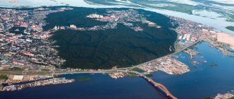
Usinsk is not a very large city with an area of 30,564 km2. The distance from its extreme southern point to the northern is 6.5 km, from the western to the eastern – 11.4 km. The geographic coordinates of the settlement are 660 north latitude and 57.520 east longitude.
It is located on the European continent, almost at the farthest northeastern point.
The settlement is located on the East European Plain, another name for which is the Russian Plain. The Ural Mountains are considered the eastern border of the platform, while Usinsk is located in the very east of the East European Plain - in the Cis-Urals. This territory is characterized by forest-tundra and taiga.
The closest access to the World Ocean for Usinsk is the Barents Sea, or rather its southeastern section, called the Pechora Sea. The distance from the city to the coast is about 300 km due north. In this area the altitude above sea level is about 75 m.
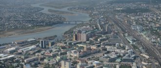
The terrain is flat, the surface is covered with forest-tundra and heavily swamped. Sometimes there are slightly hilly areas. The largest rivers are Usa and Pechora.
In addition, in the Usinsk region there are several smaller rivers:
- Kolva;
- Ski;
- Big Makarikha;
- Sharyu.
The surface waters of this region are represented not only by rivers, but also by swamps, the largest of which is Usinsk. It is one of the largest and most significant systems of raised bogs in the northern taiga on the European continent. The system includes not only swamps, but also approximately 860 lakes.
The soils in this area are dominated by podzolic illuvial-humus and illuvial-iron, bog-podzolic and swamp.
History of Usinsk
The settlement owes its origins to local oil fields. In its development, Usinsk has gone through a difficult path from the first reconnaissance expedition to the modern industrial center of the entire region.
You can find out about the city's attractions here:
The main milestones of this path can be reduced to the following chronological events:
- 1960 - the first drilling rig was installed near the Usa River . It revealed the presence of oil reserves in the depths of the area. Although many years will pass before the appearance of the city of Usinsk, the prerequisites for its emergence appeared precisely at this time.
- 1962, October – the first oil was produced at the Usinsk site.
- 1964 - a village began to be built for oil industry workers.
- August 31, 1966 - a village called Usinsk was officially registered. Geographically, at that time, he was part of the Kolvinsky village council. This day can be considered the founding date of the settlement of Usinsk.
- 1970, March - the foundation of the future city of Usinsk takes place near the village. So far it consists only of wooden houses.
- 1972-1973, winter - the beginning of laying the main oil transportation route - the Usinsk-Ukhta oil pipeline . Already in August 1973, oil began to be pumped along it. This moment marks the beginning of industrial oil production in this area.
- 1973, October 26 - creation of the Usinkneft organization, which managed local oil production.
- 1974, March - the beginning of the construction of the Usinsk-Synya railway, the length of which was 115 km. Usinsk is its final destination.
- 1974 - the village received electricity through the Ukhta-Pechora-Usinsk power line.
- 1974, December 24 - construction of the only secondary school was completed.
- 1975, February 21 - registration of the new Usinsk district, the central settlement of which became the village of Usinsk.
- 1975, May 1 - the first house made of building panels, consisting of 5 floors, was built.
- 1977, January 1 - Usinsk was able to receive and dispatch passenger flights thanks to a new runway.
- 1984, July 20 - the status of the village of Usinsk increased. Now it has become a city.
- 1989, November 18 – the Tomlun cinema was opened.
- 1994, January - Usinsk residents got the opportunity to visit a large swimming pool. It is divided into children's and adults', and there are seats for spectators.
- 1995 - creation of a local museum dedicated to the history and nature of the region.
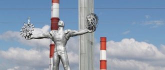
Monument to the Oilman
This small town is home to an interesting monument that is very much loved by visitors and its native residents. The townspeople call it “The Beggar” among themselves, but in fact this monument is dedicated to the discovery of an oil field in 1973. The worker with outstretched hands symbolizes that this deposit will bring glory and life to the city and its population. This painting really deserves special attention and a visit.
Location: Oilmen Square.
Natural monuments
On the map of Russia, protected natural attractions located in the vicinity of Usinsk are concentrated near the small Sharyu River, the left tributary of the Usa.
These include:
- rock "Ring";
- rock outcrops “Middle Gate of the Sharyu River”;
- Sharyusky natural monument.
The “Ring” rock is located on the right bank of Sharyu , approximately 48 km from the place where the river flows into Usa. Another name for this geological monument is “Window”. The formation is a dolomite rock in the shape of a regular isosceles triangle, the middle of which is hollow.
A void measuring 2.5 x 5 m was formed due to frost weathering processes. The height of the “triangle” is approximately 6 m, the width of the base is 15 m. The attraction is located on a steep slope of the river bank, at a height of 20-30 m above the water surface.
On March 29, 1984, the Council of Ministers of the Komi Autonomous Soviet Socialist Republic classified the “Ring” rock as a geological natural monument.
3.5 km up along the bed of the Sharyu River there is another natural attraction - rocky outcrops “Middle Gate of the Sharyu River” . These include a half-kilometer-long section of the river, similar in appearance to a canyon.
The height of the rocky shores in this area reaches 70 m. The “Middle Gate of the Sharyu River” was recognized as a natural monument under state protection by the Decree of the Government of the Komi Republic in 2002. The Sharyu natural monument can be found at a distance of approximately 50 km from the mouth of the Sharyu.
It is located on both sides of the riverbed. The monument consists of large areas of unique rocky rocks emerging to the surface on the steep slopes of the banks, reaching 60 m in height. The length of the section is approximately 1 km. The exposed rocks are valuable due to the presence of geologically significant fossils in them.
The attraction was taken under state protection at the same time as the “Ring” rock.
Nature reserves
Natural reserves of the Usinsk region are represented by:
- Usinsk complex reserve;
- Nebesanyur swamp;
- Ichthyological reserve.
The Usinsky complex reserve is a collection of reservoirs, mainly represented by swamps.
The reserve covers the vicinity of 4 rivers:
- Pechora;
- Usa;
- Big Son;
- Bolshaya Vyatkina.
Nebesanyur is a nature reserve, which includes a whole complex of swamps. It is located to the right of the Kolva River. The flora includes 52 species of plants (shrubs, grasses, sphagnum). The reserve covers an area of 1600 hectares.
The Usinsky Ichthyological Reserve includes a section of the Usa River from Cape Pictor to the confluence of the Ponyu River into the Usa, as well as forest lands on both sides of the Usa. Its area is 7800 hectares. This territory was declared a nature reserve by the Decree of the Council of Ministers of the Komi Autonomous Soviet Socialist Republic dated March 29, 1984 in order to create safe conditions for the spawning of fish of the whitefish family.
Natural resources
The Usinsk urban district is located in the forest-tundra and extreme northern taiga zones. 11.8% of the area is covered with swamps, another 23.2% is covered with vegetation: shrubs and trees. Most forests consist of coniferous trees, spruce being the most common, sometimes mixed with birch. The forest areas have the configuration of large islands.
Vast areas are covered with swamps. The fauna of the region is represented by animal species characteristic of both the tundra and taiga.
The forest-tundra zone is inhabited by:
- reindeer;
- polar wolves;
- white partridges;
- swans;
- geese;
- ducks
The following types are typical for the taiga:
- moose;
- the Bears;
- hares;
- stoats;
- martens;
- foxes;
- proteins;
- wood grouse;
- black grouse;
- hazel grouse.
The main mineral resources of the Usinsk region are oil and gas. 70% of the oil and 60% of the gas of the entire Komi Republic is produced here.
The main oil and gas fields include:
- Verkhnevozeiskoe, located 101 km north of Usinsk;
- Usinskoye, located 20 km northwest of the city;
- Vozeiskoe, located 75 km north of Usinsk;
- Baganskoe, the peculiarity of the weather conditions is frequent snowstorms, the distance to Usinsk is 60 km.
In addition to hydrocarbon raw materials, the subsoil of the Usinsk region contains some other minerals:
- Thanks to the abundance of swamps, the area is rich in peat. However, it is not mined, although a large number of deposits have been discovered.
- Mineral building materials (sand, gravel) are mined to service the oil industry. Reserves of expanded clay, building stone, and mineral pigments have been discovered.
- Ground waters, mineral and fresh.
Industry of Usinsk
70% of the industrial capacity of the Komi Republic is located in the Usinsky region. About 27 thousand people are involved in labor activity. The main share of industrial production falls on the development of oil and gas fields. This industry in Usinsk is represented by the two most significant oil producing enterprises: Lukoil and Rosneft.
Transportation of extracted hydrocarbon raw materials is carried out by the company, which is a branch of Transneft PJSC.
On the map of Russia, Usinsk is located in a region where exploration is revealing more and more new oil deposits, so this industry will determine the future development prospects of the area for a long time. However, the industry of Usinsk is represented not only by oil production.
There is a plant for large-panel house construction here . The food industry is represented by a plant for the production of bakery products and a plant for the processing and production of meat and dairy products. The region's climate does not support extensive agricultural development.
Nevertheless, in the Usinsk region, vegetables are grown in greenhouses and fodder crops in open ground. Cattle breeding is represented mainly by reindeer herding and breeding of Kholmogory cows. This breed was bred in northern Russia and is the most resistant to the harsh conditions of the region.
Architecture and sights of Usinsk
The architectural landmarks of the city are two churches. The Temple of the Icon of the Mother of God “Softening Evil Hearts” was built of wood in 2003. The stone Church of the “Resurrection of Christ” in artistic decoration is second only to one church in the Komi Republic - St. Stephen’s Cathedral.
Features of the settlement are the following monuments and attractions:
- a fountain with light and music, the construction of which was dedicated to the 25th anniversary of Usinsk;
- the monument to the defenders of the Fatherland is dedicated to participants in 3 wars: the Great Patriotic War, Afghan and Chechen;
- bust of S.A. Dusouche, a geologist who was among the first to explore the lands of the north;
- stadium;
- monument to the oil worker mosquito.
Usinsk also has:
- city exhibition hall VORTAS, where you can see works of artisans and artists of Usinsk and neighboring settlements;
- Museum of History and Local Lore;
- the Usinsk mosque is the largest in the Komi Republic;
- Oilman statue;
- Monument to the First Builders;
- amusement park;
- Usinsk Palace of Culture.
Memorial dedicated to "Defenders of the Fatherland"
All residents of the city value and respect this monument, as it is endowed with a special meaning, gives them faith and provides support in any situation. Townspeople visit this place on special dates in their lives: at a wedding, on the birthday of a child. They all unanimously declare that the monument to the “Defenders of the Fatherland” is of particular value to them and maintains a connection with their past.
Location: Neftyanikov street.
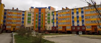
Urban development and planning
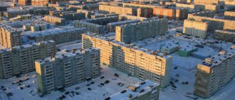
The streets in the city are straight. Residential development is mainly represented by houses made of building panels with 5 and 9 floors. In the Pionerny district there is a small number of 2-story barracks. A new generation house appeared in the city in 2010. It features an improved layout and the presence of garages for residents.
The lower floors are occupied by offices.
Monument to the Book
The city has a monument dedicated to books, which reminds tourists and locals every day of the value of knowledge gained over the years from their own experience and lessons from the works of our great authors. In this place, excursions are often held among the younger generation, who should also be in awe of literature and the knowledge that it gives to its readers.
Education and science in Usinsk
The following institutions operate for preschoolers and schoolchildren in Usinsk:
- 11 kindergartens;
- 1 orphanage;
- 1 school for primary schoolchildren;
- 6 secondary schools;
- Center for Additional Education for Children;
- an open shift school for high school students who combine study with work or obtaining a profession.
For secondary vocational education, there is a Polytechnic College in Usinsk, and a branch of the Ukhta State Technical University for higher education.
Rowan Square
A rowan garden was formed in Usinsk, where various kinds of events and holidays can be held, as well as private walks for citizens. The square is equipped with high-quality street lighting and benches where guests of this place can sit and enjoy the wonderful view of nature. In the center of this property is a monument in the form of an unfolded book, on which there is an engraving with the words of the great Russian writer.
Interesting facts about the city
Although the history of the city goes back a little over 30 years, Usinsk managed to stand out with some interesting features and events:
- Usinsk was formed later than all other cities of the Komi Republic. After it was given city status in 1984, not a single similar settlement was formed.
- The Usinsky district is noted in the Guinness Book of Records due to a sad reason - in 1994, a major oil spill occurred here, the consequences of which are still felt by the Usinsk residents.
- Vozeiskaya Street coincides with line 660 north latitude.
- Of all the cities of the Komi Republic, only Usinsk has no sights immortalizing Lenin.
- The Yenisei oil refining enterprise operates in the Usinsk region. It is located north of all similar enterprises in the world.
- The Usinsk bog is one of the most extensive peat bogs in Europe. In the Komi Republic it ranks second in size. The distance between the extreme northern and southern points of the swamp is more than 40 km, its age is over 9 thousand years.
Despite its small size on the map and short period of existence, Usinsk is in the top 100 industrial centers of Russia.
Article design: E. Chaikina
Usinsk – a city of oil workers
The city owes its birth to oil fields. Despite the difficult natural and climatic conditions, it is an important part of the country’s oil industry. Usinsk today is the oil capital of the Komi Republic.
Our city was founded in 1966. It was a small village, and the people who inhabited it lived at that time in trailers and barracks. The first houses made of timber were built only in the spring of 1970, and on May 1, 1975, the first five-story panel house was put into operation. Usinsk was given city status in 1984.
From the first day of its existence, the city has been multinational. Mosques and churches stand side by side here. I can’t remember any interethnic conflicts. Usinsk was declared a youth Komsomol construction site. People came from all over the vast USSR in search of romance and, of course, money.
The country needed oil, and people extracted it. They built drilling rigs and pulled many kilometers of oil pipelines. Severe frosts and snowstorms could not prevent the development of the rich bowels of the Komi land. The pioneer people were real heroes, strong in spirit and faith in the bright future of their country.
Usinsk is currently a transshipment base for shift workers. Every day a large number of shift workers arrive or depart by airflot and rail. Many people come in search of work. Usinsk is a small city, but it can be difficult to navigate due to the densely packed buildings.