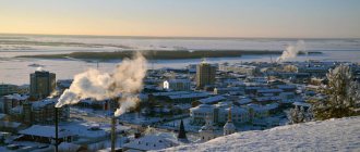
Beloyarsky
(Khant. Nuvi sunkhum) is a city in Russia, the administrative center of the Beloyarsky district of the Khanty-Mansiysk Autonomous Okrug-Ugra.
Population - 19,797 people. (2021).
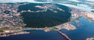
The city is located on the left bank of the Kazym.
As an administrative-territorial unit, Khanty-Mansi Autonomous Okrug has the status of a city of district significance. Within the framework of local self-government, it is included in the municipal district (Beloyarsky) and forms the municipal formation of the urban settlement of Beloyarsky
as the only settlement in its composition.
Story
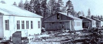
Previously, this territory was called Khuv Sangkhum (Russian: Long Yar). It was a tasty place for deer, so collective farm and private herds grazed here. Carts of reindeer teams traveling along the winter road Berezovo - Polnovat - Amnya - Numto and back stopped here for the night to give the reindeer an opportunity to feed on white moss. After the discovery of gas fields in Yamal in 1959, the construction of gas pipeline compressor stations was required. In June 1969, a landing party of seven people landed on the banks of the Kazym River.
The first three construction organizations SU-9, SU-10 and SU-2 organized the Kazymsky site (later Beloyarsky), named after the Kazymsky village council of the Berezovsky district, on whose territory it was located.
In 1970, SU-35 was organized, which began construction of the first stage of the compressor station. At the same time, construction of housing and social and cultural facilities was carried out.
The first houses appeared on Lenin Street. A school was also built here, which opened in 1972, with 150 children studying there. In 1973, Beloyarsky was given the status of a village. In the fall of 1974, a village council of people's deputies was formed.
In the 1990s, a folklore archive of the Northern Khanty was created in the city, the long-term director of which was the Hungarian ethnographer researcher and teacher Eva Schmidt.
In 1996, a wooden temple of Seraphim of Sarov was built in Beloyarskoye. In 2001 it burned down. In 2003, a stone temple of Seraphim of Sarov was erected in its place.
Map
| Beloyarsky: maps |
Beloyarsky: photo from space (Google Maps) Beloyarsky: photo from space (Microsoft Virtual Earth)
| Beloyarsky. Nearest cities. Distances in km. on the map (in brackets along roads) + direction. Using the hyperlink in the distance , you can get the route (information courtesy of the AutoTransInfo website) | |||
| 1 | Berezovo | 82 () | Z |
| 2 | Let's play | 126 () | SW |
| 3 | Priobye | 139 () | YU |
| 4 | Oktyabrskoe | 143 () | YU |
| 5 | Nyagan | 185 () | YU |
| 6 | Muzhi (Yamalo-Nenets Autonomous Okrug) | 210 () | NW |
| 7 | Nizhnesortymsky | 293 () | SE |
| 8 | Soviet | 305 () | SW |
| 9 | Salekhard | 313 () | WITH |
| 10 | Yugorsk | 316 () | SW |
| 11 | Aksarka (Yamalo-Nenets Autonomous Okrug) | 319 () | WITH |
| 12 | Khanty-Mansiysk | 325 () | YU |
| 13 | Labytnangi | 326 () | WITH |
| 14 | Nadym | 344 () | NE |
a brief description of
Located in the north of Western Siberia, on the river. Kazym (tributary of the Ob), 293 km north of the railway. Priobye station (by water, along the winter road - 210 km), 370 km northeast of Khanty-Mansiysk (by air) and 819 km north of Tyumen.
Beloyarsky is the base for further construction of gas pipelines and development of the Yamal Peninsula.
Territory (sq. km): 72
Information about the city of Beloyarsky on the Russian Wikipedia site
Historical sketch
Founded in 1969 as a settlement for oil workers, Bely Yar, in connection with the development of natural gas fields in the north of the Tyumen region and the construction of a compressor station for the Nadym-Punga gas pipeline. Since 1974 PGT. Since 1988 the city of Beloyarsky.
Yar - “high steep bank; cliff,” and the definition white indicates the color of the exposed rocks.
Economy
Enterprises serving gas transportation.
In the Beloyarsk region: reindeer husbandry, fur farming (arctic fox, silver-black fox). Fishing farms.
Signs of oil were found.
Culture, science, education
Berezovskaya oil and gas exploration expedition.
Museums, galleries, exhibition halls
Beloyarsk Museum of History and Local Lore 628161, Khanty-Mansiysk Autonomous Okrug - Ugra, Beloyarsky district, Beloyarsky, st. Central, 19
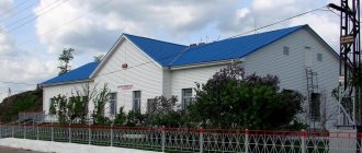
Architecture, sights
It is built up with multi-storey residential and administrative buildings.
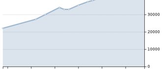
| Population by year (thousands of inhabitants) | |||||||
| 1970 | 0.4 | 2001 | 18.3 | 2011 | 20.3 | 2018 | 19.8 |
| 1979 | 7.5 | 2003 | 18.7 | 2012 | 20.2 | 2019 | 19.5 |
| 1989 | 20.5 | 2005 | 19.5 | 2013 | 20.2 | 2020 | 19.6 |
| 1992 | 18.4 | 2006 | 19.8 | 2014 | 20.2 | 2021 | 19.8 |
| 1996 | 16.6 | 2007 | 20.0 | 2015 | 20.3 | ||
| 1998 | 17.8 | 2008 | 20.1 | 2016 | 20.3 | ||
| 2000 | 17.9 | 2010 | 20.2 | 2017 | 20.1 | ||
Coat of arms
In a dissected azure (blue, blue) and green field there is a standing silver reindeer. At the golden tip there is an azure ball framed by a silver flame running through the middle.
The golden base of the heraldic shield represents the wealth of the region's subsoil - the basis of its well-being. Along the golden base there is a thread of a gas pipeline with a point of a blue torch, the Beloyarsky point on the map, which appeared thanks to this gas pipeline.
The two colors of the shield field are green and blue, a symbol of the two primary colors of nature: green for forests, blue for rivers and lakes. These are the colors of the flag of the Khanty-Mansiysk Okrug, of which the region is an integral part.
Against the background of the blue-green field of the heraldic shield is the silhouette of a white reindeer. It symbolizes the city’s territorial affiliation with the northern regions.
The white deer is like the pure protective spirit of the eternal, living nature of the region.
The coat of arms is decorated with a national pattern - a symbol of the ancient culture of the indigenous peoples (Khanty and Mansi).
The author of the Belykh coat of arms is Vladislav Savvovich, born 02/01/1948, lives in Beloyarskoye.
Beloyarsky
(Khanty-Mansiysk Autonomous Okrug - Ugra)
OKATO code:
71181
Founded:
1969
Urban settlement since:
1974
City since:
1988 City of district subordination (Beloyarsk district of the Khanty-Mansiysk Autonomous Okrug)
Center:
Beloyarsk district
Telephone code (reference phone)
| 34377***** | — |
Deviation from Moscow time, hours:
2
Geographical latitude:
63°43′
Geographical longitude:
66°40′
Altitude above sea level, meters:
22 Sunrise and sunset times of the Sun and Moon in the city of Beloyarsky
Gender and age
Considering the distribution by gender in the region, it is worth noting that the number of women here, since 2005, has always prevailed over the number of men. Here are the indicators Rosstat shows, indicating the number of women per 1,000 men:
- In 2005, the fairer sex numbered 1,026.
- In 2010 – 1041.
- By 2014 – already 1052.
- By 2016 – 1053 women.
- And by 2022, there were 1,054 women per 1,000 men.
As can be seen, under the influence of a number of factors, including the shorter life expectancy of men, the number of women per 1000 males is constantly growing. If we consider age indicators, then today the age composition of the population is divided as follows by the end of 2022:
- Children under 1 year – 22,500.
- Children under 7 years old – 186,000.
- From 8 to 13 years – 136,000.
- From 14 to 17 years old – 80100.
- From 18 to 19 – 31.000.
- From 20 to 24 – 83.600.
- From 25 to 29 – 110.200.
- From 30 to 34 – 161.500.
- From 35 to 39 – 154.600.
- From 40 to 44 – 136,300 people.
- From 45 to 49 – 119.500.
- From 50 to 54 years old – 109,500.
- From 55 to 59 years old – 127,200.
- In the age group 60-64 years – 95,500.
- In the range from 65 to 69 years – 58,000.
- Over 70 – a little over 52,000.
Thus, the working population is a total of 1003,700 citizens, the younger than working population is 386,600. But the pension category of people is 273,500.
Migration
If we consider migration issues, here is what the inflow and outflow of the population looks like year by year over the past few years:
- In 2022, 76,217 people arrived.
- In 2022, this figure was 75,582.
- The bulk of arrivals are Russians who migrate within the country. Their number accordingly amounted to about 66,000 over 2 years.
- Of international migration, most citizens came from Azerbaijan, Armenia, and Tajikistan. Less so from other Slavic republics of the former USSR.
- But the picture will be incomplete if we do not say that there is a category of people who leave Khanty-Mansi Autonomous Okrug. So, for the same reporting period from 17 to 18. XXI century, the number of those leaving was about 80,000 annually. Moreover, the main part moves within the country, settling in other regions.
This is what the demographic situation looks like in the Khanty-Mansiysk Autonomous Okrug. And now it has a positive character compared to many other regions of the country.
Cities
The administrative center is the city of Khanty-Mansiysk. The Autonomous Okrug also includes a number of the following large cities:
- Beloyarsky - the population here exceeds a little more than 19 thousand people.
- Kogalym - about 67 thousand people live in the agglomeration.
- Langelas - just over 44,000 inhabitants.
- Nefteyugansk is a large city by the standards of the region with more than 127,000 inhabitants.
- Nizhnevartovsk - more than 277,000 citizens live on its territory.
- Surgut is the largest populated area, with a population of more than 380 thousand people.
- Yugorsk with a population of 37,000, as well as a number of smaller settlements and smaller settlements.
Geographical position
Beloyarsky district is located in the northern part of the Khanty-Mansiysk Autonomous Okrug. It borders in the west with Berezovsky, in the southwest - with Oktyabrsky and Khanty-Mansiysk, in the southeast - with the Surgut region of the Khanty-Mansi Autonomous Okrug, in the east and north - with the Yamalo-Nenets Autonomous Okrug. The area occupies 41.65 thousand square meters. km. Russians (64.3%), Khanty (8.1%), Ukrainians (7.83%), Tatars (4.63%), Belarusians (1.6%) and representatives of other nationalities live here - a total of 29,876 people ( 2014)
The administrative center of the district is the city of Beloyarsky (63°43′ N, 66°40′ E).
Climate
The climate of the area is sharply continental, with rapid changes in weather conditions, which is especially noticeable in the off-season. Severe winter with snow cover 50-60 cm high lasts from November to March. Daytime air temperature is about -17 °C, night -24 °C. Summer in the Beloyarsk region is moderately warm: about +18 °C during the day, +14 °C at night. The number of days without frost in a year is from 130 to 145. The annual precipitation is from 400 to 550 mm.
Natural attractions
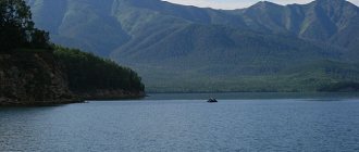
The Beloyarsk Territory is located on the right bank of the Ob, the main water artery of the region. The Kazym, Lykhma, Sorum, Pomut, Kuriekh rivers also flow here, and there are many lakes, the largest being Numto, Ai-Novy-Ying-Lor and Un-Novy-Ying-Lor.
45% of the territory is occupied by forests where pine, birch, spruce, cedar, and larch grow. The forests are rich in mushrooms (white mushroom, milk mushroom, boletus, boletus), berries (lingonberries, blueberries, cranberries, princelings, cloudberries, blueberries), nuts, and medicinal plants (rose hips, wild rosemary, Siberian fir).
Representatives of the region's fauna include brown bear, sable, marten, red fox, squirrel, black grouse, white partridge, curlew, and woodcock. About 20 species of commercial fish live in rivers and lakes: sturgeon, sterlet, nelma, muksun, roach, burbot, pike, bream.
On the territory of the Beloyarsk region there are hydrocarbon deposits, the largest being Pakhromskoye gas condensate, Verkhne-Kazymskoye, Vatlorskoye, Severo-Vatlorskoye, Lungorskoye oil fields.
In the area there is the Sorumsky nature reserve, where rare species of plants (Hebridean palmatera, small egg capsule, Lapland buttercup) and animals (white-tailed eagle, osprey, falcon) are found. Also located here is the Numto State Natural Park, where the zones of light forests of the taiga and tundra adjoin and are home to over 150 species of birds, including the white-tailed eagle, the Siberian crane, and the black stork.
Story
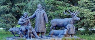
Since the 15th century, on the territory of the modern Beloyarsk region there was the Kazym principality. The indigenous population was engaged in reindeer herding, hunting and fishing. These traditional crafts continue to this day (for example, in the Numto area). Since the 70s XX century The gas transportation specialization of the region began to take shape.
Beloyarsky district is one of the youngest districts of Ugra. It was formed (split from the Berezovsky district) in 1988 and became part of the Khanty-Mansiysk Autonomous Okrug, and the Beloyarsky village became a city of district subordination.
More than 150 archeological and ethnographic monuments have been identified on the territory of the region - from the Stone Age to the late Middle Ages. The most significant are Kaksinskaya Mountain on the Amnya River, Khullor, Yuilsk and Numto.
Famous people
Heroes of the Soviet Union N.A. Popov were born in the area. and Borisov V.P. Currently, the most famous artists are Anatoly and Yuri Grishkin, natives of the village of Tugiany.
How to get there
The main mode of transport is air. There is an airport in the regional center, and there are 11 registered sites in populated areas.
In 2013, the Yugorsk - Sovetsky - Verkhnekazymsky - Nadym highway, border of the Khanty-Mansi Autonomous Okrug, opened in the region; winter roads are also functioning, including Lykhma - border of the Oktyabrsky District, which is connected to the Russian road network.
During the navigation period, motor ships ply along the routes "Beloyarsky - Priobye" and "Beloyarsky - Polnovat - Vanzevat".
Dynamics by year
Since the pre-war period, or more precisely since 1939, here is how the population in the region has changed:
- In 1939, the number of people living in the region was only 92,932.
- By 1959 it had increased to 123,926.
- By 1979 it was 569.139.
- In 1989 – 1.268.439.
- By 1999, the population continued to increase to 1,359,069 people.
- In 2009 it was equal to 1,519,962.
- For 2022, this figure was 1,663,795 citizens.
- And gradual growth continues until 2022 inclusive, thereby increasing the number of residents in this territory to more than 1.6 million.
It is worth noting that during the entire Soviet period of the Khanty-Mansi Autonomous Okrug and the Russian period, the population in the region increased almost continuously. The only exception is the period from 1992 to 1993. During this period, there was a decrease in the number of residents in the region by approximately 13,000 people. But then, starting in 1993, growth began to continue. This was achieved thanks to a developed economy and oil and gas deposits.
It is the oil and gas industry that gives economic impetus to the region and the opportunity to implement various economic and social programs. In addition, the high level of salaries, in comparison with other regions, made it possible to attract workers from certain industries here.