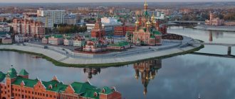
Geographical position
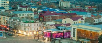
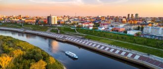
Novocherkassk is located on a small hill between the Aksai rivers and its tributary Tuzlov. The city is located 1000 km from the capital of the country, and only 30 km separates it from the main city of the region, Rostov-on-Don. Also within 30-40 kilometers of accessibility there are a number of large cities in the region - Shakhty, Novoshakhtinsk, Aksai, Bataysk. The population of Novocherkassk notes convenient transport accessibility to many amenities and benefits of large cities. The total area of the settlement is 100 square meters. km. The soils on which Novocherkassk is located are characterized by a large amount of shell rock, shale, and sandstone. The abundance of groundwater leads to the appearance of large voids under urban structures.
St. Michael the Archangel Church
On the map Photos
A stone church designed by local architect Yakov Sedov was built on the main Platovsky Avenue on the territory of the Azov Bazaar in 1870 and consecrated in 1872. Archbishop Platon of Don and Novocherkassk participated in the consecration. It was a two-tiered brick church with chapels: on the top floor, the right chapel in honor of the Vladimir Icon of the Mother of God and the left in honor of the Cathedral of John the Baptist. On the lower floor the main altar is Panteleimon's, with a chapel on the right side in the name of St. Father Simeon the Holy Fool and John the Faster. In 1906, on the initiative and at the expense of the church elder P.P. Derepatskov. repairs were made, and the temple's paintings were updated. At the same time, church and parish guardianship was organized. The further fate of the Archangel Michael Church is similar to the fate of other outlying city parish churches. Most likely, it was closed just like the others, in 1935. According to some reports, it started working again in 1943. According to some stories, the temple was allegedly closed again in 1960, during another mass atheist campaign. A new stage in the revival of the Archangel Michael Church began in the early 90s.
Settlement history
Novocherkassk, whose population we are considering, has a unique history. It was immediately planned and built as a capital city. In 1805, for a number of economic, political and environmental reasons, it was decided to move the capital of the Don Cossacks from Cherkassk to a new location. The former capital was flooded every year, so first of all they looked for a new location where such disasters were impossible. The Emperor of the Russian Empire favorably accepted the request to move the capital and sent the famous city planner General Devolan to carry out the decision.
Novocherkassk was planned in the best traditions of European culture. Wide avenues, boulevards with green spaces, and spacious squares were laid out here. Despite the attractiveness of the new capital, the local population was in no hurry to move, and construction proceeded slowly. Therefore, in the first decades the city developed primarily as a location for military units. Many administrative and public buildings and government housing were erected here, but there was almost no private development. Only with the advent of industrial enterprises did the influx of residents gradually begin to the city, but this process was very slow. During the years of revolutionary events in the country, a center of white resistance was formed in Novocherkassk, which led to a significant increase in population.
In 1920, the city was finally taken by the Bolsheviks. During Soviet times, the settlement developed as a large regional, industrial and scientific center. Then the Cossack past of the city was carefully hushed up, and only in 1993 Novocherkassk was declared the capital of the World Cossacks.
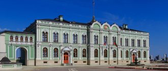
Central Library named after. A.S. Pushkin (former Officers' Assembly)
On the map Photos
The library moved to the building of the former Officers' Assembly with the advent of Soviet power in 1920. Built for the Don Cossack Army in 1890, it was truly unique. The building of the former officers' meeting is one of the most significant buildings in Novocherkassk at the end of the 19th century. It acquired its final appearance as a result of the reconstruction of the house and the appearance of an extension on a plot purchased nearby at the intersection of Moskovskaya and Komitetskaya streets. The building was built in a style typical of the architecture of the 17th-19th centuries. classicism style, which is characterized by strict forms of facades and decorative stucco and iron decorations, rounded windows. The main hall was intended for celebrations and meetings.
Climate and ecology
Novocherkassk is located in a temperate continental climate zone, with mild, short winters and long, hot summers. The average annual temperature is about 9 degrees Celsius. Winter in the city begins in December and ends at the end of February. In January, the coldest month of the year, the thermometer can drop to minus 20-25 degrees, but on average it stays around -8. Summer in Novocherkassk begins in May and lasts until the end of September. In August, the thermometer can rise to 40 degrees Celsius, but the average summer temperature is +23. At the same time, in summer the population of Novocherkassk, Rostov region, experiences a rather acute lack of moisture, especially in August. It receives approximately 60 mm of precipitation throughout the year, with the wettest months being January, February and June.
While the climatic conditions of Novocherkassk are generally favorable for living, the environmental situation leaves much to be desired. The city is experiencing big problems due to water pollution in the rivers, and hence there is a shortage of drinking water. The region's industry significantly pollutes the city's soil and air. The Novocherkassk administration is working to solve these problems, but has not yet achieved much success in this direction.
Novocherkassk
(Rostov region)
OKATO code:
60427
Founded:
1805
City since:
1805 City of regional subordination
Telephone code (reference phone)
| 86352***** | 23-209 |
Deviation from Moscow time, hours:
0
Geographic latitude:
47°24′
Geographic longitude:
40°06′
Altitude above sea level, meters:
80 Sunrise and sunset times in the city of Novocherkassk
Administrative division and population distribution
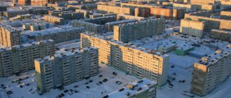
The small size of Novocherkassk is the reason that there is no official division into administrative units. But the population of Novocherkassk independently identified separate parts that have official and unofficial names. So, there are the districts of Center, Oktyabrsky, Molodezhny, Vostochny, Sotsgorodok, Cheryomushki, as well as small parts called Kosmos, Galinka, Khotunka, Novoselovka. Some time ago, the city was absorbed by the Tatarsky farm, which retained its name. The average population density of the city is 1329 people per 1 sq. km. But the city center is the most populated, and the Molodezhny, Sotsgorodok, and Oktyabrsky districts are the least favorable, and residents try to leave here.
St. George's Church
On the map Photos
St. George's Church was built on Kolodeznaya Square in Novocherkassk in 1898 in memory of the miraculous rescue of Sovereign Emperor Alexander III and His august family during the crash of the royal train on October 17, 1888. Arch. V.N. Kulikov drew up a project, taking the church in the village of Nizhne-Chirskaya as a model. The church was built in the Russian style on a sloping site towards the Tuzlov River. Instead of a bell tower, an original belfry was built above the refectory. The capacity of the temple is 400 people. The temple was built with private donations and cost 17 thousand rubles. The largest contribution was made by the widow of the cornet F.V. Kashcheev. The iconostasis was made in the workshop of A. Solovyov, window frames and crosses from shaped iron - in the workshop of T.H. Fasler. The consecration of the temple took place on October 18, 1898. In 1939, the temple was closed. In the post-war years it was used as a granary. At the end of the 1940s. the temple was returned to the Church and became operational again. Its restoration began in 1990. The temple preserves the shrines that have been there since its construction: icons of St. blg. book Alexander Nevsky in a silver frame, St. Panteleimon the Healer of the Athonite script. Of particular interest is the miniature wall iconostasis with paintings from the academic school. The original work is the cast iron bas-relief “The Last Supper”, a copy of the famous fresco by Leonardo da Vinci. In October 2000, St. George's Church acquired a new shrine - the icon “It is Worthy to Eat”, a copy of the myrrh-streaming icon from St. Mount Athos.
Population dynamics
They began to count the population of Novocherkassk from its very foundation. In 1811, 6.7 thousand people lived here. In the first decades of the settlement's existence, the population growth was slow; noticeable growth began in the second half of the 19th century. So, in 1863, 18 thousand people lived here, and by the end of the century there were already 50 thousand. Before the revolution, there were about 70 thousand people in the city, and after it it decreased to 42. In Soviet times, the population dynamics was positive. By 1989, 188 thousand people lived in the city. But perestroika led to the beginning of a long period of decline in the number of residents. In some years the dynamics were positive, but the overall trend was negative. Today there are 170 thousand people in the city, and the forecasts are still disappointing.
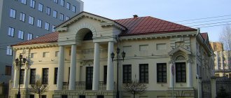
Ataman Palace
On the map Photos
A two-story building in the classicist style. The Ataman Palace served as the residence of the military ataman, as well as the residence of the royal family who visited the city. These were Alexander II, Alexander III and Nicholas II. Design and construction were carried out by Academician I.O. Valprede in 1863. The rich decoration of the interior makes an indelible impression: state rooms with high vaulted ceilings, stucco moldings and paintings, huge marble fireplaces and carved furniture. Everything here points to the former presence of royalty. The courtyard adjacent to the back of the building in those days was decorated with flower beds and ornate paths, as well as a carved gazebo installed on a raised platform.
Economy of the city
During Soviet times, Novocherkassk, whose population is closely connected with its economy, became a major industrial center. In 1936, an electric locomotive plant was built here, which today is an important enterprise for the economy of the region, employing almost 10 thousand people. In the 50s, a synthetic products plant was launched in the city. At its best, up to 3 thousand people worked here. Today the plant is almost stopped, only one workshop is functioning. At the same time, the electrode plant began operation, which today is one of the largest metallurgical enterprises in the region.
The stability and profitability of the city's economy is also ensured by an enterprise for the production of petrochemical equipment, several large food and construction companies, two clothing factories, and enterprises in the social and cultural spheres. There are two universities and about a dozen secondary specialized educational institutions in Novocherkassk. The volume of production per capita in the city is 67 thousand rubles.
Novocherkassk Ascension Cathedral
History On the map Photos
Novocherkassk Ascension Cathedral is considered one of the most majestic in Russia, the third largest church building, second only to the Cathedral of Christ the Savior in Moscow and St. Isaac's Cathedral in St. Petersburg. Novocherkassk Cathedral is not only an Orthodox church, but also a historical monument of the Don Cossacks. His story is complex, but at the same time very interesting. More details
Employment
A large number of stable economic enterprises provide employment for a large number of residents. The Employment Center (Novocherkassk), which collects vacancies from all enterprises in the city, records one of the lowest unemployment rates in the region - only 0.5%. The main vacancies are associated with a shortage of blue-collar workers. But people with higher education, especially young professionals, do not always manage to find a suitable job. Women under 40 with higher education experience the greatest difficulties in finding a job.
Alexander Nevsky Church
On the map Photos
The church, designed by the architect Lavopierre, was built wooden, and therefore temporary, so its construction took little time. On June 29, 1810, Archpriest Alexey Oridovsky consecrated the newly built church. There was only one throne in the Alexander Nevsky Church, in honor of the holy noble prince Alexander Nevsky. In 1822, one of the residents of Novocherkassk, “who loves the splendor of the house of the Lord,” added a chapel to the church in the name of St. Great Martyr Paraskeva Pyatnitsa, consecrated on October 26 of the same year by Archpriest Jacob Merkhalev. December 22, 1896 The last liturgy was celebrated in the old wooden Alexander Nevsky Church, during which priest Vasily Petrov made a heartfelt speech about love for his temple, which for 86 years was the center of the spiritual life of many people. In 1898, the low, gloomy, cold and dark old church was dismantled and transported to the Mishkin village of the Novocherkassk village, where a new church was built from this material, consecrated on November 12, 1900. The new Alexander Nevsky Church, built behind the Alexander Garden (now the city park), was built, like the Ascension Cathedral, in the New Byzantine style, one-story, with a semicircle in the altar, behind which there is a room for the sacristy. The temple can accommodate up to 1,500 people for one service. The main dome inside is decorated with a picturesque image of the God of Hosts, and the semi-domes and walls of the temple are decorated with images of events from sacred history and the faces of saints, as well as sacred sayings. An iron staircase leads to the bell tower. The outside of the church was whitewashed, and plaster was placed only around the windows and doors. The inside of the temple was completely plastered, painted with oil paint and decorated with paintings.
Demographics
The Employment Center (Novocherkassk), which conducts sociological research on the city's demographic indicators, notes that the birth rate is gradually increasing, and the mortality rate is decreasing. But still the indicators are still disappointing. There is also a problem of migration outflow of the population from the city, which leads to negative dynamics in the number of city residents. On average, the number of city residents is reduced by 2 thousand people annually. Statistics show that the life expectancy of city residents is gradually increasing, but men are showing a less confident increase in the number of years lived. The ratio of city residents by gender in Novocherkassk generally corresponds to all-Russian trends; there is one woman for every man.
Triumphal arches
History Photos Northern Arch on the map Western Arch on the map
The triumphal gates at the northeastern and southwestern entrances to Novocherkassk preserve the memory of the heroic participation of the Don Cossacks in the Patriotic War and foreign campaigns of 1812-1814. More details
City infrastructure and quality of life
Small cities in Russia generally cannot compete with large, developed settlements, and Novocherkassk is not a happy exception. The city's population experiences a shortage of large cultural, healthcare, and trade facilities. But this problem is being successfully solved by nearby cities. But difficulties with buying housing and finding employment for young people lead to the fact that school and university graduates often leave the city. The infrastructure is poorly modernized, there are problems with roads. All this, of course, reduces the quality of life of people and their loyalty to the place.