Yoshkar-Ola is the capital of the Mari El Republic. The city was founded at the end of the 16th century on the banks of the Malaya Kokshaga River. Some residents of the country do not know where Yoshkar Ola is located. It is located in the Mari Lowland, near the taiga zone.
The city's climate is characterized by cold winters, but also warm summers. The city has the Malaya Kokshaga River. She divides it into two parts.
Natural areas and reserves of the city of Yoshkar-Ola
In the area where Yoshkar Ola is located, there are a large number of environmental sites. For example, nature lovers should visit the Botanical Garden of the State University.
This garden is a reserve in which rare plants grow, many of which are listed in the Red Book. It is curious that over thousands of plant species grow in such a garden.
Be sure to visit the pine grove within the city. It has a fairly impressive area - over four hundred hectares. Centuries-old pines are very valuable. Their average age reaches two centuries. And the oak grove is located in the southern part of the city.
Despite the fact that its area is somewhat smaller and has been somewhat modified by human activity, it is still of great value for nature lovers. Many species of valuable and rare trees grow here.
Train Station
The Yoshkar-Ola railway station is a station in the Kazan region of the Gorky Russian Railways, which is located on the 106th km of the Zeleny Dol - Yaransk section. The number of platforms is 2, the number of departure tracks is 10. The railway station is located at st. Yanalova, 3. The railway station building houses a spacious waiting room, ticket offices, and storage room for luggage and personal belongings. There is also a medical center and a cafe at the station.
A long-distance train departs from the Yoshkar-Ola railway station in the direction Yoshkar-Ola - Moscow. Suburban trains that go to Kazan and Tabashino are also serviced.
Architectural monuments of Yoshkar-Ola
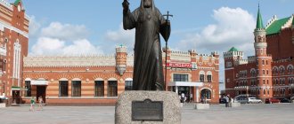
The region of Russia where Yoshkar Ola is located is associated with many historical figures and events. For example, Tsarevokokshay Kremlin. It was recreated five years ago. This is the historical center of the city. The complex has a unique monument to Tsar Ivan the Terrible in all respects. According to some reports, it is the only one in the world.
Tsarevokokshay Kremlin
Diversity of Nationalities
As for the ethnic composition of the city, it has 96 different peoples. The majority of the population in the territory is Russian - 68%. Next come the indigenous Mari - 24%. The third place in number is occupied by the Tatar peoples - 4.3%. In addition to the main national composition, the urban population of Yoshkar-Ola consists of:
- Chuvash;
- Ukrainians;
- Azerbaijanis;
- Armenians;
- Uzbeks;
- Belarusians;
- Udmurts;
- Georgians;
- Germans and many others.
Other city attractions
The area where Yoshkar Ola is located is unique in many ways. If this is your first time in this wonderful city, be sure to visit Nogotkov-Obolensky Square. This is one of the most interesting places in the ancient city. There is a monument to the governor of Tsarevokokshaisk (that’s what this city was once called).
The square is named after him. Near the monument is an exact copy of the capital’s Tsar Cannon. An art gallery is located on the same square. It is not as big as in the capital, but still the largest in the city.
But in Arkhangelskaya Sloboda there is a monument to a big, big cat, which nobly arched its back. And near the agricultural ministry of the republic, a shelter and a calf are grazing. This is “Ode to the Russian Burenka”. And at the University of Mari there is... Yoshkin's cat - a favorite vacation spot for students.
Yoshkin cat
The area where Yoshkar Ola is located is full of the most unexpected and unusual places worth visiting. To have time to visit this city, satellite-controlled chimes will come to the rescue. The city is looking forward to guests and is ready to open up to each of them.
Automobile highways
Federal highways pass through Yoshkar-Ola:
- P176 “Vyatka” is a federal highway. The total length of the route is 872 km. The road originates in Cheboksary and passes through Yaransk, Kotelnich, Yoshkar-Ola. The final point of route P176 is the city of Syktyvkar. The road surface of the route is asphalt concrete.
- A295 is a federal highway with a total length of 126 km. The road starts in Yoshkar-Ola and passes through Zelenodolsk and Volzhsk. The end of route A-295 is the M-7 Volga highway.
Short story
The birth of the city of Yoshkar-Ola is associated with the largest event in the history of the Mari region - the entry of the Mari people into the Russian state in the middle of the 16th century, after the defeat of the Kazan Khanate. It was founded as a fortress in 1584 by order of Tsar Fyodor Ioannovich, in the dense, impassable forests and swamps of the low-lying left bank of the Volga, on its tributary, Malaya Kokshaga. Initially, the fortress was known as Kokshazhsk, later - Kokshatsky town, and then - Tsarevokokshaysk.
Since 1708 the city has been part of the Kazan province, and since 1781 it has been a district town of the Kazan governorship. The Tsar's city on Kokshaga remained wooden for a long time. At the end of the 19th century, in the city, which in appearance resembled a village, there were 6 churches (including 5 stone ones), a convent (founded in 1890), and there were 186 wooden and 8 stone houses. A distillery and tannery operated.
In 1919, the city of Tsarevokokshaysk was renamed Krasnokokshaysk, and in 1928 - Yoshkar-Ola, which means, translated from Mari, Red City. From 1936 to 1990, Yoshkar-Ola was the capital of the Mari Autonomous Soviet Socialist Republic, and currently the capital of the Mari El Republic.
The city of Yoshkar-Ola is located on the Mari Lowland, 50 km north of the Volga, on its left tributary - the river. Malaya Kokshaga. The climate is moderate continental. Average temperatures in January are -13°C, in July 19°C. Precipitation up to 500 mm per year
The municipal entity “City of Yoshkar-Ola” is located in the center of the Mari El Republic and 862 km from Moscow. This is a complex administrative-territorial unit. Yoshkar-Ola is not only a city of republican significance, with a 420-year-old
history and being the capital of the Republic of Mari El. Its historical feature is that the city at different times included more than 20 surrounding villages. In addition, the municipality covers a number of settlements,
subordinate to the Administration of Yoshkar-Ola, and not only directly adjacent to the city, but often located at a considerable distance from it. These are Sidorovsky (center - Nolka village), Semenovsky (center - Semenovka village), Kundyshsky (center - village
Silikatny), Kuyarskoye (center - Kuyar village) and Kokshaysky (center - Kokshaysk village) village councils. Therefore, the geographical location of the municipal formation “City of Yoshkar-Ola” is peculiar and unusual. It is surrounded on all sides by the lands of the Medvedevsky district, and on
in the south it wedges into the territory of the Zvenigovsky district and comes out on the banks of the Volga. Water meadows and partly farmland and forests approach the city from the north, farmland from the west and northwest, and forests in the southeast, south, and southwest of the city.
arrays. Settlements located near the Kokshay tract are surrounded by forests of the State Forest Fund.
The territory of Yoshkar-Ola, together with the rural settlements assigned to it, is 110 square meters. km, including urban land itself - 56 sq. km, the rest is arable land, urban forests, hayfields and pastures, gardens and country houses
cooperatives. The city of Yoshkar-Ola is not only surrounded by green forests on almost all sides, but also has fairly developed “lungs”. City parks, squares and other green spaces occupy more than 1,600 hectares, of which 801 hectares are urban forests (Pine Grove, Oak
grove, etc.), for which the status of specially protected natural areas has been introduced.
According to the results of the 2002 All-Russian Census, the population of the city, together with its subordinate rural administrations, is 281.1 thousand people.
The city of Yoshkar-Ola is located in the center of the Mari Lowland, in an area of mixed forests, actually on the southern border of the taiga zone. The Malaya Kokshaga River, a tributary of the Volga, flows through the city. Within the boundaries of the municipality, the Oshla rivers flow into it,
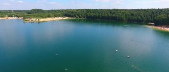
Managa, Maly Kundysh, Nolka. The southern border of the municipality is the left bank of the Volga and the mouth of the Bolshaya Kokshaga flowing from the virgin forests. On its territory there are the most beautiful lakes Tair, Karas, Shap and others. All this creates favorable
recreational opportunities for citizens and residents of other regions of Russia.
The administrative-territorial structure of Yoshkar-Ola and its environs developed historically over a long period of time. We can trace this process back into history until the middle of the 16th century.
As part of the Kazan Khanate, the Mari did not have cities; they lived in small settlements - “ilems”. The area of present-day Yoshkar-Ola and its environs was part of the Galician Daruga of the Khanate. It is not known which settlement was its administrative center, but most likely it was located closer to the capital of the khanate. At that time, the territory of modern Yoshkar-Ola and its environs was the northern periphery of the Kazan Khanate, through which trade, economic and military-political ties were carried out between Kazan and the northeastern Russian lands. In particular, it is known that this area was crossed by the Galician Road, which ran northwest from Kazan towards the city of Galich, an important medieval city in northeastern Rus'.
After joining the Moscow state in the second half of the 16th century, the administrative-territorial structure and management system characteristic of Russian lands were introduced here. Before the construction of Russian fortified cities on the Mari lands, the entire territory of the left bank of the Volga was under the control of the Kazan governor. The cities of Kokshaysk (1574) and Tsarevokokshaysk (1584), which were then founded here, had their own districts with a tax-paying (yasak) population and, among the “lower cities”, until the beginning of the 18th century, were directly subordinate to Moscow, the Order of the Kazan Palace.
When Peter I divided Russia into provinces in 1709, Tsarevokokshaisk and Kokshaisk with their districts were included in the Kazan province. And in 1719, when it was divided into provinces, these cities and counties ended up in the Sviyazhsk province.
Devastating fires, unfavorable economic conditions and social upheavals of the 18th century reduced the city of Kokshaysk to the status of a rural settlement of Tsarevokokshaysky district, which was determined already in 1765, when the Kazan governor, based on the general instructions of Empress Catherine II on the consolidation of districts, ordered to “attribute” Kokshaysk and the left bank part of his district to Tsarevokokshaisk and deprive it of city status. Thus administratively the destinies of the two were united
settlements. True, in 1904 the village of Kokshayskoye and surrounding villages were transferred to the Cheboksary district and with the formation of the Mari and Chuvash Autonomous Regions in 1920, Kokshaysk first became part of the latter, but in 1925 it was transferred to the Mari Autonomous Region, and thus , the fates of the two ancient cities were united again.
And the history of Russian villages that appeared near Tsarevokokshaisk immediately after its foundation and later on lands liberated from the local Mari population through eviction, was always directly and firmly connected with the history of the city. When
suburban settlements of Russian peasants became the property of the royal family, historians were unable to find out, but in the 17th century they were palace settlements. They were united into the Palace volost (in some documents - the Palace Country volost). Since 1797 there was
The Department of Appanages was created, accordingly, the palace peasants began to be called appanages, the Tsarevokokshay palace volost was renamed the Varaksa appanage expedition, then the Varaksa appanage order. In 1863, appanage peasants were
freed from serfdom in relation to the royal palace. Their villages made up the Varaksinsky volost. At the beginning of the twentieth century, it consisted of 23 villages, 17 of which are currently either streets of the city of Yoshkar-Ola, or are located in
administrative subordination of the municipal formation "City of Yoshkar-Ola".
As for the surrounding Mari population, they had the right to live at a distance of at least five miles from the city walls. But the influence of the city also extended to him. This was expressed not only in the payment of yasak and other duties in the city, but also in
the policy of Christianization, which over time was reflected in administrative and managerial relationships. The nearest Mari villages were part of the Nolinskaya volost; their inhabitants were already converted to Christianity in the 17th century (and perhaps already at the end of the 16th century).
faith and united into a special Podgorodny Novokreschenskaya volost. Subsequently, they belonged to the larger Arban volost. In particular, these were Bolshoye Chigashevo and Maloe Chigashevo, Chikhaidarovo, Alenkino, which are now part of the city. In contrast
from the nearest Russian palace (appanage) villages, the Mari residents were yasak (from the time of Peter the Great - state), that is, they belonged to the feudal state as a whole. Like neighboring Russian villages, they were attached to city churches.
Tsarevokokshay district was initially small in area and population. According to Catherine’s reform of 1781, it increased not only due to the former city of Kokshaysk and two Trans-Volga (left bank) volosts of the former Kokshay district, but
and due to significant territories transferred from Kazan and Tsarevosanchur districts.
In this form, it remained as part of the Kazan province for a long time, specifically until the revolutionary upheavals of the early twentieth century, and even more precisely until 1920. When the Tatar ASSR was formed in May 1920 with
capital in the city of Kazan, the Kazan province was disbanded. At the same time, Krasnokokshaysky (formerly Tsarevokokshaysky) district without two south-eastern volosts inhabited by Tatars was temporarily transferred to the Vyatka province.
On November 4, 1920, the Mari Autonomous Region was proclaimed by decree of the All-Russian Central Executive Committee and the Council of People's Commissars of the RSFSR. On November 25, the All-Russian Central Executive Committee and the Council of People's Commissars adopted a new decree, according to which the territory was determined
region: Krasnokokshaysky district of the Vyatka province became entirely part of the Mari Autonomous Region, and the city of Krasnokokshaysk was declared the center of the new administrative unit.
By the decision of the Revolutionary Committee of the MAO of January 15, 1921, the Krasnokokshaysky district was renamed into a canton with the same name, with the annexation of the volosts that separated from the Yaransky district of the Vyatka province, and the volosts (including suburban ones - Varaksinskaya,
Petrikovskaya, Arbanskaya and others) remained in the same form for a long time; rural societies (communities) were also preserved - mainly to resolve issues of land use and land management, and for more convenient operational management
The volosts were divided into village councils (selsoviet).
In 1924, a new administrative-territorial structure was introduced in the Mari Autonomous Region. The Krasnokokshaysky canton was disaggregated, the Morkinsky and Orsha cantons were separated from it. The volosts as a legacy of tsarism were abolished and
The village councils (near the city - Koryakovsky, Bolshechigashevsky and others) became the lowest basic administrative units.
The construction of the Zeleny Dol - Krasnokokshaysk railway was of great importance for the formation of the settlement appearance of the modern municipal formation “City of Yoshkar-Ola” (as well as for the Volzhsky and Zvenigovsky districts). It is in the process
This led to the formation of the villages of Kuyar, Surok, Silikatny, Kundysh, and Pemba.
In January 1928, Krasnokokshaysk received the Mari national name - Yoshkar-Ola (Red City), and the canton began to be called Yoshkar-Olinsky, and since 1932 the cantons were renamed into districts. Although to manage the affairs of the city directly in
In 1927, the city council was formed; it was essentially in the position of a village council, that is, it was subordinate to the canton (then district) council. District institutions, although they were called Yoshkar-Ola, were located not in the city itself, but in a suburban village
Nechaevka, which was then included in the boundaries of Yoshkar-Ola.
In connection with the transformation of the Mari Autonomous Region into the Mari Autonomous Soviet Socialist Republic in December 1936, the city of Yoshkar-Ola became its capital.
Carrying out capital functions (first as the administrative center of the autonomous region, and then formally and legally called the capital of the autonomous republic), Yoshkar-Ola expanded its borders - first at the expense of free urban lands,
but over time this turned out to be not enough. “Free” lands were at the disposal of villages in which collective farms were formed in the early 1930s. Although in 1935-1936 they received state acts for the “eternal use” of the eternally mastered
their lands, all land in the Soviet state since 1917 was declared state property, and state bodies could dispose of it at their own discretion. Certain difficulty for republican and city authorities to use
for urban buildings of the surrounding collective farm lands was represented by the fact that they were part of the district. Therefore, in the second half of the 30s, many surrounding villages (Varaksino, Koryakovo, Nechaevka, Lapshino, Markovo, Zhukovo, Shiryaykovo and Pakhomovo) were
included within the city limits. Now the seizure of land for urban buildings became easier, and this practice was continued during the war years and after.
During the Great Patriotic War, it was decided that the Yoshkar-Olinsky district was too large in territory compared to many other districts and cumbersome to manage. In December 1943, the Medvedevsky district was separated from it, which included a number of
settlements currently subordinate to Yoshkar-Ola. The remaining part continued to be called the Yoshkar-Ola district, and district institutions were still located in the village of Nechaevka, which became a continuation of the Kommunisticheskaya Yoshkar-Ola street. IN
In 1946, district institutions were transferred to the village of Semenovka, and the district began to be called Semenovsky (existed until 1959 and was merged with the Medvedevsky district).
In the post-war years, Yoshkar-Ola was built up intensively in the western and southern directions, and then in the Zarechnaya part to the southeast, reshaping the existing grid of suburban and intra-city villages.
In the drawings of new city streets and blocks drawn by architects, there was no place for them, and they either disappeared completely (like, for example, the village of Koryakovo, which in the last years before its disappearance was called Kolkhoznaya Street), or from them
scattered, torn fragments remained (for example, the village of Lapshino, which at one time bore the name of Papanin Street, later named after Olga Tikhomirova).
In the 60s-70s, a line was consistently pursued for the growth of Yoshkar-Ola through the transfer of nearby settlements under its management. The airport village, Semenovsky, Kuyarsky, Kundyshsky, Kokshaysky were transferred to the Yoshkar-Ola City Executive Committee
village councils, from the Bolshechigashevsky village council the Prigorodny village council was separated and given to the city, consisting of the village of Bolshoye Chigashevo itself, the villages of Nolka and Svetly.
By decree of the Presidium of the Supreme Soviet of the RSFSR dated December 27, 1973, Yoshkar-Ola was divided into two districts: Leninsky and Zavodskoy. In addition to the city blocks themselves, they included rural settlements: in the first - Kundyshsky, Kuyarsky,
Semenovsky, Solnechny village councils, in the second - Kokshaysky and Prigorodny village councils (soon abolished), then the Sidorovsky village council of the Medvedevsky district was included here. The regional division of Yoshkar-Ola was abolished on August 16, 1988, but rural
the settlements remained part of the city.
The most significant of the subsequent changes in the relationship between the city and surrounding rural settlements were determined by the Decree of the Presidium of the Supreme Council of the Republic of Mari El dated October 14, 1993 “On establishing the border
between the city of Yoshkar-Ola and the Medvedevsky district of the Republic of Mari El", on the basis of which the villages of Alenkino, Myshino, Tarkhanovo, which were transferred to the city not long before, and Bolshoye Chigashevo, which entered the city limits relatively long ago, were
By decree of the mayor of the city, they were renamed into streets while maintaining their previous names, and the village of Rabochiy became a continuation of Mashinostroiteley Street.
In this book, essays about settlements that disappeared due to the expansion of Yoshkar-Ola or became city streets, or were subordinated to a municipal entity, were written taking into account these circumstances.