Elbrus
It is considered the highest mountain in Europe and is an extinct volcano. The mountain has two peaks, one is in the east, the other in the west, at an altitude of more than 5000 m or more. There is snow on the mountains, even if it is hot. Every year many tourists come to Elbrus to climb it. It should be noted that a cable car was built here, and you can find a hotel or restaurants nearby. Experienced tourists say that there are healing springs nearby.
The word "Elbrus" is translated from Zend - this is the people who once ruled Iran - as "high mountain".
The weather in the mountains of Kabardino-Balkaria in the Elbrus region is as follows: cool in summer, usually humid. At an altitude of 2000 m, the maximum temperature in summer is + 35. The higher the altitude, the lower the temperature; at 3000 m it becomes 10 degrees less. Somewhere in early September, the autumn period begins; on peaks around 3000 m, autumn begins in October. The higher you go, the thicker the snow cover, and it can reach 50 meters. And at the beginning of May spring comes. At an altitude of more than 5000 m, snow will not melt at all, even if the air and temperature are favorable for this.
Cultural sites: Upper Balkaria, City of the Dead, One Hundred Steps to Kaisyn
Kabardino-Balkaria is a predominantly natural region. There are not as many cultural sites here as in other regions of Russia. However, the republic compensates for this small omission with its landscapes. Nevertheless, history buffs have something to see in the CBD. Move towards Upper Balkaria - there are many towers and ruins of the 9th century. It's not for you to climb through abandoned rubbish! Archaeologists are conducting excavations here, which are helping to find new features of the culture of local peoples. Residents of the republic also associate a terrible tragedy with Upper Balkaria. In 1944, the NKVD mistakenly accused local residents of aiding the Nazis, for which Balkars were deported en masse to other republics. The order was merciless:
“Destroy everything that can revive the soil for banditry. Do not show pity under any circumstances... During hostilities, take hostages.”
Therefore, Upper Balkaria has such cultural and memorable value for all local residents.
The City of the Dead is several necropolises in the village of Eltyubyu. The first burials here date back to the 10th century. There are several versions of the appearance of crypts. First: it is inconvenient to dig ordinary graves in the mountains. I think that the theory is simple and practical, like five kopecks. The second is more interesting from a historical point of view. At that time, Zoroastrianism was widespread in the Caucasus. According to the customs of this religion, the deceased cannot be burned or buried - this way you desecrate the two dominant elements - fire and earth. That's why people made crypts. By the way, some of them are decorated according to Muslim traditions. Apparently, the new religion was not able to supplant the old funeral customs, because some of the tombs date back to the 15th century. You probably know the feeling when you can’t part with a forgotten thing for a long time.
However, there are also architectural objects in the CBD that are not related to death. The poet Kaisyn Kuliev was born and raised in Eltyubyu. His work is an important aspect of the cultural life of the USSR. That’s why people’s love was manifested by the creation of the “One Hundred Steps to Kaisyn” memorial. This is a brilliant idea: the house where the famous poet was born is led by a wall where his poems are carved. You go, look at the nature that Kuliev admired, and read his poems. You immediately feel unity with the author - as if you are looking at the surroundings through his eyes. The road of life and creativity of Balkar pride.
Girlish braids
This waterfall is located in the mountains of Kabardino-Balkaria and is a place worth seeing. If you find the Terskol mountain peak, then on the slope you will just see this waterfall.
If you look at the streams of water that flow down, it seems as if it was a girl spreading her hair. The height of the waterfall is 30 m. Judging by the lower part, its width is about 15 m.
At the top there is a glacier called Gara-Bashi, it melts and a waterfall flows from it. It's very beautiful, the views are amazing and picturesque, and if you come here during the warmer months, it's a great place to cool off.
Blue Lakes
Of the natural attractions, a group consisting of 5 karst lakes deserves a visit. The entire complex is conventionally divided into lower and upper reservoirs. The water in the lakes is crystal clear. At a depth of more than 20 meters, the bottom is quite clearly visible.
Blue Lakes
The largest in area, but at the same time the smallest, is Lake Superior, which is fed by precipitation. Its water level varies slightly throughout the year.
- Location: in Chereksky district at a distance of 30 km from Nalchik.
- How to get there: The A-154 motorway is nearby.
- Visit: free.
Kumkyugenkaya
It belongs to the mountains of Kabardino-Balkaria and is located in the Chegem volcanic region, with an altitude of more than 3000 m. As you can see, there are interesting figures on the plateau itself. The main peak is considered to be Kutube. On the plateau you can find a lake.
Many tourists come here just to look at these figures. Some figures resemble people, some resemble animals and camels. Tourists laugh because there are figures that resemble movie and cartoon characters.
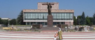
Monument “Forever with Russia”
Before the formation of the Republic of Kabardino-Balkaria, there were separate historical regions - Kabarda (Big and Small) and Balkaria. This region of Kabarda was annexed to the territory of Russia more than 400 years ago. And on the anniversary of the entry of these lands into Russia, the monument “Forever with Russia” was erected. The architect is V. Oltarzhevsky, the work was done by sculptors S. Makhtin and M. Listopad. The monument embodies the image of the Motherland, the image of a woman who gives peace to her people. At the bottom of the monument you can see bas-reliefs telling about important events in the history of the republic.
Location: Nalchik, 400th Anniversary Square.
Rest
In Kabardino-Balkaria, a vacation in the mountains can be very exciting. To do this, you can arrange an excursion, go to the Blue Lakes or go to a ski resort in the Elbrus region.
If you go to the village of Terskol, then it is best to relax here from November to April. Ski slopes can be found near Elbrus and Mount Cheget. There are three tracks on Elbrus, even a beginner can ride here.
On Cheget they are a little more difficult, and the slopes there are more dangerous. If you want to snowboard, it is best to go on the mountain slopes as they have the most snow.
Near the Cherek-Balkarsky River you can find Blue Lakes. There are as many as 5 lakes, they are located at an altitude of 800 m above sea level. The depth exceeds more than 300 m. This lake has very clear water, so a dive center was specially built on the shore. Here you can find locker rooms, an equipment preparation room, storage, a compressor room, and camp sites.
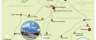
Sights of Kabardino-Balkaria
This park dates back to the 19th century, when it was decided in 1847 to establish an orchard for the recreation of officers of the Nalchik fortress. And the garden was founded at the Nalchik fortification, and fruit trees were brought into it from the Crimea and Georgia - apricots, apple trees, pears, plums, grapes. The trees took well, and soon an amazing garden-forest with fruit trees and linden alleys arose. In 1865, the garden was presented to Prince Atazhukin. The prince did not care much about the safety of the garden, and as a result it was neglected. In 1920, it was decided to improve the garden and make it a resting place for the townspeople, as a result of which the executive committee decided to add flower beds and walking alleys to the park.
1921 is the year of foundation of the National Museum of the Kabardino-Balkarian Republic - the center of all local history works of the republic. The museum has its own library, and local history and local history clubs operate on the basis of the museum. Excursion texts are prepared specifically for certain categories of visitors.
From time immemorial, Kabardian horses were considered one of the best; they were purchased for cavalry in Tsarist Russia. In Soviet times, horse breeding was not forgotten, and in 1931 the Presidium of the regional executive committee decided to build a permanent hippodrome in Nalchik. The decision was delayed for several years, but in 1939 the racecourse was built. Problems began very soon, when during the Great Patriotic War huge damage was caused to the horse population. It was possible to restore it to the level it was in the pre-war years only in the early 1960s. And then the hippodrome finally came to life to the fullest, the racing business began to improve, and everyone remembered how good Kabardian horses once were.
The appearance of the Friendship Memorial Arch is directly connected with the name of the President of the Kabarino-Balkar Republic, Arsen Kanokov, since it was built at his personal expense. The opening was timed to coincide with the celebration of the 450th anniversary of the union of Kabarda and Russia. Muzarib Bzhakhov is the author of the arch project. Initially, the idea was to decorate the arch with bas-reliefs depicting scenes from Adyghe history and the Nart epic.
Lake Syltran-Kol is one of the most beautiful high-mountain lakes in the Caucasus. It is located at an altitude of 3000 meters above sea level, and its area is about 10 hectares. Translated from Turkic, the name of the reservoir sounds like “beautiful lake”. Lake Syltran-Kol is located in the pit of a rock-talus circus. To get to it, you need to take a route to two equal mountain peaks - Syltran and Mukal, which are located at an altitude of 3900 meters above sea level, because it is between them that the lake is located.
Cheget is one of the highest mountains in the Caucasus. Its height reaches about 3770 meters. It is a popular tourism destination among travelers. From the mountain you can enjoy the view of the highest peak in Europe – Elbrus. Another feature of Mount Cheget is the second line of the cable car, which passes through an area where there is snow that does not melt throughout the year. There are three lines of the cable car in total. The height of the first reaches about 1600 meters. It is one of the most popular for tourists who come to Cheget to enjoy the view of Elbrus.
The "Maiden's Braids" waterfall is located on rocks called "Ram's foreheads" near the Terskol peak at an altitude of about 3,100 meters above sea level. You can see the waterfall up close by going up to it along one of several routes. An easier way is the road along the southern trails of Terskol Peak. For those who prefer extreme sports, there is another way - the tractor road to the Terskol gorge. The waterfall itself is 30 meters high, and the width at the very bottom is about 15 meters. It is fed by the melting Gara-Bashi glacier.
Lake Donguz Orun-Kol is surrounded by two peaks - Donguz-orun-bashi and Nakra-tau, whose heights are 4450 and 4228 meters, respectively. The lake is located slightly lower than the surrounding mountains at an altitude of about 3100 meters. The name of the lake translates as “next to the pig pen.” It is located on the border between the Russian Federation and Georgia. A special feature of the reservoir is its unusual color, which the lake received thanks to glaciers. The thing is that, along with water from melting glaciers, minerals from the mountains enter the lake, which color the lake in three colors. The reservoir is flowing, on one side the Donguzorun River and the large Medvezhy Stream flow into it, and the Donguz-Orun Baksan River flows out.
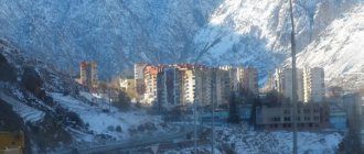
Glade Azau is the highest point of the Elbrus region, which is inhabited by people. It is located at an altitude of 2300 meters above sea level near the village of Terskol. The glade is directly adjacent to the foot of Elbrus. Azu is a village that mainly consists of various hotels and tourist centers. All the places where a traveler can stay in the clearing are built along its perimeter, forming a small square inside; between the hotels there are many cafes and small restaurants serving Caucasian and European cuisine.
This mountain, after Elbrus, is the second most popular among climbers. This is because it is also quite high - 4454 meters above sea level.
There are several ways to get to the mountain: by cable car or on foot. Tourists who choose the first method can use the Cheget cable car at the final point, where small cafes are located. The second and more difficult path, which takes several hours, is from the Cheget meadow along a path already crowded with tourists. However, it is better to hit the road with an experienced guide, otherwise there is a chance of getting lost in the mountains.
The monument to the first conquerors of the highest peak in Europe, Mount Elbrus, welcomes everyone who decides to enjoy the view of the mountain and follow the path of these pioneers. The monument stands on a bridge that runs across the fast mountain river Baskan. The monument to Killar Khashirov and Akhiya Sottaev was erected in the 70s of the last century; since then it has been restored, but has retained its original appearance to this day. The conquest of Elbrus took place in 1829; the original expedition consisted of 20 people, but only Killar Khashirov managed to climb to the top.
The river originates from the glaciers of the highest mountain in Europe - Elbrus. The river is one of the longest in the republic, but it is also highly polluted due to the nearby industrial plant. In the vicinity of the river there are mountaineering camps, the Elbrus National Park, and an observatory. According to some sources, the river received its name in honor of Prince Bakan, who lived in the Caucasus. After the brutal murder of the prince and his family, they were buried near the river, which was then named after him. The river is popular among rafting enthusiasts. This is due to the fact that in its upper reaches Baskan descends 65–70 meters for every kilometer of the route. With each subsequent kilometer the river slows down.
One of the most impressive natural monuments in the Elbrus region. However, it is located in a place difficult to access for tourists, the Djily-Su tract on the territory of Kabardino-Balkaria. There are no communications or settlements with hotels and tourist centers. The only people you can meet here are climbers who are going to conquer Elbrus and shepherds grazing their flocks. In total, there are three waterfalls in this place, which appeared thanks to protruding rocks at the formation of the Malka River. However, "Sultan" is the tallest and fastest of them.
The lakes are located in the Zolsky region of Kabardino-Balkaria and represent two reservoirs: Shadhurey-First or “big lake” and Shadhurey-Second or “Small lake”. Before the beginning of the 20th century, there were two lakes, but for unknown reasons, one of them dried up, forming a pit. The lakes were formed as a result of the collapse of the earth. However, local residents found another reason; according to them, there were once camps of three brothers here, and at one point they were swallowed up by the earth, forming three lakes. Therefore, local residents were afraid to approach the lakes for a long time.
The Narzanov Valley is located on the border of the Kabardino-Balkarian Republic and the Stavropol Territory, just a few tens of kilometers from Kislovodsk. It is there that the valley of the Khasaut River is located, which is a tributary of the Malka. Descending into the river valley you can see the majestic Mount Elbrus. The Narzan Valley is surrounded on all sides by various landscapes and reliefs.
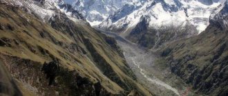
The Baksan Gorge is considered the most famous in the Central Kazkaz, leading to the foot of Elbrus. The gorge originates from the Skalisty and Pastbishchny ridges, in an area with sparse forests. The ridges pass through the villages of Lakshuty and Zhankhoteko. From this point on, nature takes on a new character. On one side you can see limestone steep walls of a white and yellow hue, on the other - a cliff to the Baksan River.
Mother Mountain
In addition to the above mentioned mountain names, Kabardino-Balkaria is also famous for others, among them we can recall Dykhtau, Koshtantau, Ulu-Tau. It is worth noting that the latter is called Mother Mountain in Kabardino-Balkaria.
Shamans come here in search of solitude, and there are also rumors that the mountain cures infertility. An interesting fact is that all the women who visited the mountain with a request to be cured of this disease became pregnant.
In the Caucasus, such legends have been passed on for many years. But the mountain will not fulfill all the little things, only the most important and cherished things.
The mountain is very majestic, you can see the pristine beauty there. People who came here say that this place gives the impression of a real temple.
Tourists should remember that Mount Ulutau in Kabardino-Balkaria requires special treatment when climbing it!
- You need to give up meat and not eat it. The benefits of civilization are also prohibited.
- There is a special house where all the guests of the mountain come, and you will not find electricity there; in order to warm water or food, they make a fire.
- Next, meditation is performed, it is similar to prayer.
- You need to take a piece of cloth, write a wish on it to formulate your dream, then tie it to a tree, which is located near the mountain.
Scientists cannot in any way explain what is happening here; there is a hypothesis that the mountain is like an antenna that provides communication with higher powers. The mountain shows favor towards women, but also fulfills the desires of men.
Mother Mountain in Kabardino-Balkaria is located in the Elbrus National Nature Reserve. Near it there is a base for tourists and climbers.
If you are heading there, drive from Mineralnye Vody to Nalchik and Kislovodsk. It is better to go by train, or go by plane.
If you are in Mineralnye Vody or nearby cities, then you can find offers for excursions. It is worth noting that it can be expensive, because there is a border zone nearby, you will need an excursion visa. In connection with this fact, it is best to contact a travel agency.
You will drive about 50 kilometers to Elbrus, then you will see a waterfall and a gorge, from here you need to go on a lift with your car, there is a road in the forest, you will drive about 12 km to the camp. After which you will find a climbers’ camp. You should know that after this camp you will have to walk to Mount Ullu-Tau in Kabardino-Balkaria.
Remember that if you are traveling with your own transport, you need to order a special pass for the car in advance, otherwise you will not be allowed into the border zone.
But along the road you can meet people who sell all sorts of things made from wool and the like. Border guards walk around the territory - they can check your passport.
When people in Kabardino-Balkaria ask how to get to the Mother Mountain - Ulu-Tau, it is better to act like experienced tourists. They do this: they take a ticket to Nalchik, get there either by plane, or by train, or some other way. From Nalchik they go to the village of Verkhny Boksom. The transport stop is called Adyr-su gorge. And then get out, take the lift, and walk to the camp. Then you settle down and ask there how to go hiking to the mountain. Near Ullu-Tau you will find at the foot of a wishing tree, a stone where people also leave their notes.
sacred mountain
Mount Ulu-Tau in Kabardino-Balkaria is considered sacred and belongs to places of power. There are a lot of such places in the Caucasus; there really is a powerful energy here, which people have noted more than once. Near the mountain, a shaman ritual is performed using tambourines. All energy centers open, information about the future and answers to questions are obtained. Not far from the mountain there is a Silver Key, it is healing because there is a lot of silver there. Therefore, water can cure many diseases. You can take it with you in a bottle and bring it home.
In the mountains of Kabardino-Balkaria, the photos are always beautiful, because there are amazing places here. It is recommended to take photo and video equipment; you can go to a village called Eltyubyu. This place is considered anomalous because something incomprehensible is happening there over time. The clock starts to lag or does not go. If you leave milk or meat even in summer, nothing will happen to them.
Mentality
In the republic, two peoples have lived together for centuries: Kabardians and Balkars.
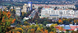
They have different languages and different histories. The first are direct descendants of the Circassians and Circassians, the indigenous settlers. They speak Adygebze. The second are relatives of the Karachais, a Turkic-speaking people. So if you speak Tatar or Kazakh, you can understand them. Kabardians are the dominant ethnic group in the republic, while Balkars occupy third position, behind the Russians. Local people, as elsewhere in the Caucasus, are extremely responsive. They will never leave you in trouble and will offer help if needed. Legends were formed about their character. Both Kabardians and Balkars are extremely poetic - they described the courage and generosity of their ancestors in mythical tales - the Nart epic. The Narts are heroic heroes, like our Ilya Muromets, only with a thick beard and no mustache. According to legends, they lived in the lands of the Caucasus and tried to establish peace and order. Legends about fearless warriors testify to the pagan period in the life of the Kabardians and Balkars. Now they profess Islam. There are a lot of villages and auls in the region, where life moves at a leisurely pace. People are engaged in cattle breeding and agriculture. Young people don’t like this way of life, so they move to the capital of the republic - Nalchik. The city is small by Russian standards, but it offers more prospects than a village. By the way, the events of the film “Tightness” took place here. If you love movie trips, then CBD should be the next item on your list.
Dykhtau
Translated as “Steep Mountain”. It is considered the second highest after Elbrus. There are two high peaks, more than 5000 m. You can also highlight Pushkin Peak. There are more than 10 routes laid by climbers. The Bezengi climbers camp is also located there.
Dyrchau is also sometimes called the “Jagged Mountain”. When compared with Elbrus, the mountain does not look too huge. However, compared to others, she is quite formidable. Its slopes are covered with snow that does not melt, and there are also hanging glaciers. The path to the top is very difficult.
A funny fact - this place is also sometimes called the presidium in the Caucasus, since it is here that all the highest mountains - five thousand meters high - seem to have specially gathered, but Kazbek and Elbrus are missing.
Brief history of ascents
Just as a prospector dreams of finding the largest nugget, climbers have always dreamed of conquering Elbrus. And they not only dreamed, but also conquered. Scientists became the pioneers. This happened in July 1829. Then the mountain peak was stormed by such famous personalities as the creator of the St. Petersburg geophysical observatory, Adolf Kupfer, and physicist Emilius Lenz. Even the botanist Karl Meyer and the artist Joseph Bernardazzi became climbers for a while!
The expedition was led by General George Emmanuel. Then he commanded the Caucasian fortified area. The event was purely scientific in nature. The ascent was supported by 650 soldiers and 350 Cossacks. Scientists, guides and 20 Cossacks took part directly in the assault on Elbrus. Only four reached the Eastern peak. And the Western Peak was first climbed only in 1874.
Photo: General George Emmanuel
Forty years later, Elbrus submitted to the English climbers. Then came the era of records. The German Merzbacher and the Austrian Purtscheller climbed to the top in just eight hours! In 1925, the first woman reached the summit. Since the middle of the 20th century, climbers have become widespread. And now the folk trail does not overgrow here. Elbrus beckons and attracts like a huge magnet.
There have been legendary cases in the history of conquests. So in 1974, three UAZ-469 SUVs rose to a height of 4200 meters! This was done without the help of winches. Since the air at such a height is very thin, the engines did not work at full capacity. Cars often got stuck in the snow. They had to be dug out with shovels. However, people and cars survived. A unique “ascent” has taken place!
Koshtantau
The name comes from the word “Kosh”, which means “dwelling” or “parking”. And if you look at the mountain from a distance, it becomes clear that it looks very much like a tent. Koshtantau is a hard-to-reach mountain, quite high itself. The approximate height of the mountain is more than 5000 meters. It is popular among climbers, despite the danger and possibility of death while climbing it. Clouds seem to float near its majestic peaks, and at dawn the sun paints the mountain in amazing colors.
Aushiger thermal springs
You can spend time usefully near the village of Aushiger. Here there is water saturated with all kinds of trace elements and minerals. With its help, various diseases of the skin, gastrointestinal tract, blood vessels and many others are treated.
Aushiger thermal springs
Now this place is a full-fledged resort with well-developed infrastructure. A large swimming pool was built directly next to the hot spring. It mixes river and medicinal water to maintain a safe temperature.
- Location: in the Chereksky district near the village of Aushiger.
- How to get there: by minibus or private vehicle.
- Hotel price: cost of a double room – from 2000 rubles per day.
Shkhara
This word means "Striped". Shkhara is the highest point in the main Caucasus range. It is also the highest point in Georgia. The main peak of Shkhara reaches more than 5000 km. Near the southern slope you can find a village called Ushguli. UNESCO has included it in its World Heritage List.
Shkhara is part of the so-called Bezengi Wall. This area is almost 12 m long. It is located in the highest part of this ridge. There is not one peak, but five. The wall also includes a peak named after Shota Rustaveli.
To get to the village, you should drive from Nalchik and get to the village of Bezengi. Next you need to drive 15 km along the road, but it is recommended to take an SUV as the road is unpaved. Not far from the climbers’ camp you will see a bridge that leads across the Cherek River. It is from there that you can see a piece of the above wall. By the way, the camp has electricity, you can go to the dining room, take a shower, live in tents or in a house, and there is also a cellular connection.
Most often, climbers spend the night and rest here before the next conquest of one of the slopes of Shkhara.
Donguzorun, Nakratau
If you want to find out what mountains in Kabardino-Balkaria can still surprise a tourist, then read about these. Have you ever been on an excursion to Elbrus or traveled from Mineralnye Vody? We probably ended up on a cable car and went up Mount Cheget. In addition to Elbrus, you were most likely shown Donguzorun. It has an altitude of more than 4000 m, there is also a glacier there, it is called “Seven” - because of its contour. There is also a lake there.
Actually, the mountain became known by the name of the lake. Once upon a time, Svans lived in these places and raised pigs. Therefore, the name of the lake refers to the place where these animals were bred.
Nakratau - the Svens called it “Unsharp Mountain”. Its height is 4269 m. It looks very beautiful, especially in summer, although its snowy peaks never melt.
Valley of Narzans
The Greater Caucasus Mountains have been famous for their healing waters since ancient times. One of the valleys is called the Narzan Valley, thanks to the mineral waters located there, flowing along the Khasaut River. The most favorable place for treatment, enjoying beautiful views of the mountains and surrounding nature.
Majestic mountains, clean air, the freshness of spruce forests, and most importantly, the presence of healing water, previously attracted and still attracts hundreds of people coming to the Caucasus. You can get to the Narzan Valley at any time of the year thanks to good climate conditions.
Gertybashi, Almalykaya, Mother-in-law's teeth, Kogutai
The first mountain, 4246 m high, is located in the Bezengi region, hiding behind the shadow of Koshtantau.
The second one is very beautiful, located in the Rocky Ridge. Located in the Baksan Valley. If you translate its name, the translation will be “Apple Rock”.
The third is also located in the Rocky Ridge. Nearby is a village called Bylym. If you look at the peak from the south, its name becomes clear.
The peaks of Kogutai are the most recognizable in the Elbrus region. Naturally, except for Elbrus. They form two triangles, and at the bottom there is a glacier as if in the form of a tongue. This picture can be seen near Cheget, or on the road to Elbrus.
Arc “Forever with Russia”
The theme of annexing the area of Kabarda and Balkaria into Russia runs through many architectural structures throughout the republic. In the capital of Kabardino-Balkaria, the city of Nalchik, a memorial arch was installed, its name is “Forever with Russia”, sometimes it is called the Arch of Friendship. It was located at the entrance to Nalchik on the road from Pyatigorsk. For ten years now, since 2007, it has served as a decoration of the city and has become one of the main attractions.
Location: Nalchik, Idarova street.
Bashiltau, Sugantau, Salynantau
The first mountain is located on the border of Georgia and Kabardino-Balkaria. It has a very beautiful shape: in the form of a pyramid. A glacier called Bashir originates on the slopes, and it is its waters that form the source of the Chegem River.
The height of the second is 4487 m. As you know, the Side Range is located nearby and there is a separate area. So, this mountain is the highest point of this site. Very often the ridge is called the Sugan Alps.
The third is located near the region of Chegem and Bezengi, its passes are difficult to pass, and on some of them there is a border between our country and Georgia.
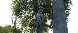
Monument to the “Heroes of the Elbrus Defense”
The events of the Great Patriotic War affected every resident of our country. Monuments and memorial signs have been erected everywhere to the grandiose exploits of great heroes. The Republic of Kabardino-Balkaria, where fierce fighting took place, is no exception. To all those who died, not sparing their lives, defending the slopes of Elbrus, a monument to the “Heroes of the Defense of the Elbrus Region” was erected.
The monument is represented by aluminum steles of different heights; the names of 219 Heroes who died in battles are indicated on them. The design of the monument belongs to V. Savostikov, V. Korneev, N. Kravchenko, and it was installed in 1986, on May 9. Every year, on memorable dates, flowers are laid here as a sign of gratitude for a calm life and peace, in memory of the fallen soldiers.