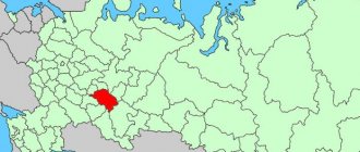
Vyatskiye Polyany
(Kirov region)
OKATO code:
33404
Founded:
1596
Urban settlement since:
1938
City since:
1942 City of regional subordination
Center:
Vyatskopolyansky district
Telephone code (reference phone)
| 83334***** | 22-2-22 |
Deviation from Moscow time, hours:
0
Geographic latitude:
56°13′
Geographic longitude:
51°04′
Altitude above sea level, meters:
100 Sunrise and sunset times in the city of Vyatskie Polyany
Attractions
Despite its size, Vyatskie Polyany has a fairly large number of historical monuments. True, the condition of many of them is not the best.
Michael the Archangel Church
This temple, a real treasure of the Vyatka region, was originally located in the village of Sushi. The church has accepted the prayers of local residents for centuries, but during the years of militant atheism everything changed: dances were held here, and then a warehouse was even built. In the end, the temple was simply abandoned.
Fortunately, in 1960, the Archangel Michael Church was recognized as a monument of history and culture. But the neglected state of the ceilings, lack of money for repairs and the small population led to the fact that the temple actually ceased to fulfill its functions.
This continued until 1998, when they decided to move the architectural monument to a place where it would become more in demand - to Vyatskie Polyany. Here he received a second life.
Today, the Archangel Michael Church is part of the Nativity Monastery under construction. A memorial plaque was installed in the temple in honor of the heroes of the Vyatka region who died in military conflicts and during the liquidation of the Chernobyl accident.
Gate Church of Onuphrius the Great
In 2000, the temple of Onuphrius the Great was erected next to the Archangel Michael Church. Since the new church was located above the entrance to the monastery courtyard, it was called the gate church. The temple and bell tower were built according to classical Russian canons.
Mother of God Convent
The Mother of God Monastery was founded in 1996. Today the monastery consists of 2 buildings. It was consecrated in honor of the monastery that operated in Vyatskie Polyany from the 16th to the 18th centuries.
The first church of the monastery is the Church of the Nativity of Christ. This house church, intended for sisters from the monastery, is located in a two-story brick sisters' building.
The second temple of the monastery is dedicated to the Iveron Icon of the Mother of God. The church was built in 2006 with donations from parishioners. It was located on the site of a small prayer house that was closed in 1961. The brick temple has a neat eclectic architecture.
St. Nicholas Cathedral
St. Nicholas Church received parishioners from 1615 to 1930. Its wooden building was replaced by a stone one in 1826. In 1893, a bell tower was built next to the church.
Like many religious buildings in the Vyatka region, St. Nicholas Church had to go through difficult times. It was closed and opened several times. In 1948, a prayer house was organized here. After its closure in 1961, Orthodox believers attended services in the city of Malmyzh. But long trips (Malmyzh is located 60 km from Vyatskiye Polyany) only strengthened the spirit of the people. Believers even organized two illegal houses of worship, in which services were regularly held. With the easing of persecution of the church in the late 80s. people turned to local authorities with a request to organize an Orthodox community in Vyatskiye Polyany. Persistence bore fruit: in 1987, the building of St. Nicholas Church was handed over to believers, who took part in the first service on January 12, 1988. A few days later, on January 20, 1988, the Church of St. Nicholas the Wonderworker received the status of a cathedral.
After many years of neglect, St. Nicholas Cathedral required a long and painstaking restoration. More than 400 local residents responded to the call to take part. In Voronezh, a bell was purchased at the expense of believers, the ringing of which echoed throughout the city on August 2, 1989.
Historical Museum
The pride of any city is its own historical museum. This institution opened in Vyatskie Polyany in 1967. The quality and content of the funds makes the museum in Vyatskie Polyany one of the best in the Kirov region. Today there are 4 exhibition halls and 1 exhibition hall, a classroom for children, and a library.
House-Museum of G. S. Shpagin
An inconspicuous building on the banks of the Vyatka from 1941 to 1952. was the home of the outstanding weapons designer Georgy Semenovich Shpagin, creator of the legendary PPSh submachine gun. In small rooms that have preserved the interior of the war years, there is an exhibition with Shpagin’s things: books, clothes, dishes.
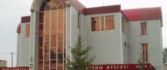
Mosque
The Vyatskopolyansky district borders the Republic of Tatarstan, so it is not surprising that a significant part of its population professes Islam. In 1989, local Muslims built a mosque in the city. In addition to worship services, it holds various training sessions for everyone. Children and adults study Arabic and the history of Islam.
Map
| Vyatskie Polyany: maps |
Vyatskie Polyany: photo from space (Google Maps) Vyatskie Polyany: photo from space (Microsoft Virtual Earth)
| Vyatskiye Polyany. Nearest cities. Distances in km. on the map (in brackets along roads) + direction. Using the hyperlink in the distance , you can get the route (information courtesy of the AutoTransInfo website) | |||
| 1 | Krasnaya Polyana | 4 (7) | NE |
| 2 | Kukmor | 10 (13) | Z |
| 3 | Sosnovka | 13 (15) | IN |
| 4 | Kizner (Udmurt Republic) | 28 (275) | IN |
| 5 | Malmyzh | 41 (57) | NW |
| 6 | Shemordan (Republic of Tatarstan) | 42 (114) | Z |
| 7 | Bogatye Saby (Republic of Tatarstan) | 44 (135) | SW |
| 8 | Baltasi (Republic of Tatarstan) | 55 (134) | Z |
| 9 | Grakhovo (Udmurt Republic) | 58 (232) | IN |
| 10 | Mamadysh | 61 (73) | YU |
| 11 | Tyulyachi (Republic of Tatarstan) | 63 (150) | SW |
| 12 | Arsk | 75 (126) | Z |
| 13 | Mozhga | 75 (230) | IN |
| 14 | Elabuga | 78 (132) | SE |
| 15 | Nizhnekamsk | 79 (197) | SE |
| 16 | Kilmez | 80 (114) | WITH |
| 17 | Vavozh (Udmurt Republic) | 80 (256) | NE |
| 18 | Mendeleevsk | 85 (154) | SE |
| 19 | Alnashi (Udmurt Republic) | 87 (192) | IN |
| 20 | Kamskie Polyany (Republic of Tatarstan) | 89 (244) | YU |
| 21 | Naberezhnye Chelny | 97 (153) | SE |
| 22 | Chistopol | 98 (250) | YU |
| 23 | Bolshaya Atnya (Republic of Tatarstan) | 99 (162) | Z |
| 24 | Rybnaya Sloboda (Republic of Tatarstan) | 102 (174) | SW |
| 25 | Pestretsy (Republic of Tatarstan) | 102 (195) | SW |
| 26 | Syumsi (Udmurt Republic) | 104 (155) | WITH |
| 27 | Uva (Udmurt Republic) | 109 (224) | NE |
| 28 | Mari-Turek (Republic of Mari El) | 109 (369) | NW |
| 29 | railway station High Mountain (Republic of Tatarstan) | 113 () | Z |
| 30 | High Mountain (Republic of Tatarstan) | 114 (167) | Z |
a brief description of
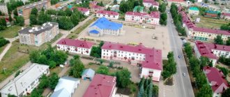
The city is located in the Urals, on the high right bank of the river. Vyatka, in its lower reaches (pier), 350 km southeast of Kirov.
Railway station on the Kazan - Agryz line.
Territory (sq. km): 28
Information about the city of Vyatskie Polyany on the Russian Wikipedia site
Historical sketch
Until the middle of the 16th century. on the site of Vyatskie Polyany there was a small Udmurt village of Oshtorma-Bodnya. After the victory of the Russian state over the Kazan Khanate in 1552, the development of the Vyatka region by Russians began.
Founded in 1596 as the patrimony of the Vyatka Assumption Monastery - the Nativity Monastery (existed until 1764). The village of Vyatskaya Polyana grew around it, becoming a village in the 17th century. a busy center for trade in grain and timber. Of the trades, woodworking and brick production were the most developed.
The name of the glade means “an open meadow tract in the middle of a forest or at its edge,” and the definition indicated its location on the river. Vyatka.
From the middle of the 19th century. The importance of Vyatskiye Polyany as a river pier increased. The pier and a significant part of the shipping company were in the hands of the owner T.F. Bulychev and his company.
The railway was laid in 1915. Moscow - Yekaterinburg, which has noticeably revived transport and trade relations with the industrial centers of the Volga region and the Urals.
At the end of the 19th - beginning of the 20th centuries. the name takes the form Vyatskie Polyany. In 1938, the village was transformed into a workers' settlement. City since 1942
Municipal indicators
| Index | 2001 |
| Demography | |
| Number of births, per 1000 population | 7.3 |
| Number of deaths, per 1000 population | 13.9 |
| Natural increase (decrease), per 1000 population | -6.6 |
| Standard of living of the population and social sphere | |
| Average monthly nominal accrued wages, rub. | 1828 |
| Average housing area per inhabitant (at the end of the year), sq.m. | 18.1 |
| Number of preschool institutions, pcs. | 10 |
| Number of children in preschool institutions, thousand people | 1.6 |
| Number of daytime educational institutions (at the beginning of the school year), pcs. | 7 |
| Number of students in daytime educational institutions, thousand people | 5.6 |
| Number of doctors, people. | 161 |
| Number of nursing staff, people. | 494 |
| Number of hospital institutions, pcs. | 3 |
| Number of hospital beds, thousand units | 0.7 |
| Number of medical outpatient clinics, pcs. | 5 |
| Capacity of medical outpatient clinics, visits per shift, thousand units. | 1.4 |
| Number of registered crimes, pcs. | 456 |
| Economy, industry | |
| Number of enterprises and organizations (at the end of the year), pcs. | 526 |
| Construction | |
| Volume of work performed by type of activity “Construction” (until 2004 - volume of work performed under construction contracts), million rubles. | 15.8 |
| Commissioning of residential buildings, thousand sq.m. of total area | 9.3 |
| Commissioning of residential buildings, apartments | 0 |
| Commissioning of preschool institutions, places | 0 |
| Commissioning of educational institutions, places | 0 |
| Commissioning of hospital facilities, beds | 0 |
| Commissioning of outpatient clinics, visits per shift | 0 |
| Transport | |
| Number of bus routes (in intracity traffic), pcs. | 3 |
| Number of passengers transported by buses per year (in intracity traffic), million people. | 5.4 |
| Trade and services to the population | |
| Retail trade turnover (in actual prices), million rubles. | 396.2 |
| Retail trade turnover (in actual prices), per capita, rub. | 9478 |
| Public catering turnover (in actual prices), million rubles. | 20.3 |
| Volume of paid services to the population (in actual prices), million rubles. | 123.5 |
| Volume of paid services to the population (in actual prices), per capita, rub. | 2954.9 |
| Volume of household services to the population (in actual prices), million rubles. | 19.7 |
| Volume of household services to the population (in actual prices), per capita, rub. | 471.7 |
| Investments | |
| Investments in fixed assets (in actual prices), million rubles. | 69.1 |
| Share of investments in fixed assets financed from budgetary funds in the total volume of investments, % | 2.5 |
Data sources:
- Regions of Russia. Main characteristics of the constituent entities of the Russian Federation: statistical collection. Goskomstat of Russia. - M:, 2003.
Economy
Mechanical engineering (production of sidecars for motorcycles, trailers, etc.). Brick factory, meat processing plant, butter factory, bakery, oil cooler, poultry factory, etc.
In the Vyatskopolyansky region, wheat, rye, barley, oats, cabbage, beets, onions, carrots, and potatoes are grown. Cattle are raised. Pig farming.
Deposits of limestone, gravel, building stone, sand, clay, peat, etc.
Main enterprises
MECHANICAL ENGINEERING AND METAL WORKING
OJSC "Vyatskopolyansky House Builder"
612910, Kirov region, Vyatskopolyansky district, Krasnaya Polyana village, st.
Druzhby, 1 Offers:
Container-type houses, furniture, fiberboard
MEAT INDUSTRY
JSC "Strateg"
612900, Kirov region, Vyatskie Polyany, st.
Depovskaya, 2 Offers:
Meat, sausages
Culture, science, education
Historical Museum.
House-museum of automatic weapons designer G.S. Shpagina.
Universities of the city
Vyatka State Humanitarian University (branch in Vyatskie Polyany)
612961, Kirov region, Vyatskie Polyany, st. Sovetskaya, 13 WWW: https://filial-vggu.narod.ru/
Vyatskopolyansky branch of Kazan State Technical University named after. A.N. Tupolev
612960, Kirov region, Vyatskie Polyany, st. Lenina, 244-246
Museums, galleries, exhibition halls
Vyatskopolyansky Historical Museum 612960, Kirov region, Vyatskie Polyany, st. Sovetskaya, 51 Phone(s): (83334) 6-24-80 Website: https://vp-museum.rf/
Architecture, sights
Nicholas Church (1826).
17 km from Vyatskie Polyany, in the village of Sushi, there is a wooden Archangel Church (1733).
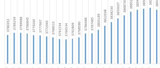
| Population by year (thousands of inhabitants) | |||||||
| 1939 | 10.6 | 1996 | 42.6 | 2007 | 39.0 | 2015 | 33.3 |
| 1959 | 25.7 | 1998 | 42.3 | 2008 | 38.8 | 2016 | 33.1 |
| 1967 | 31 | 2000 | 42.2 | 2010 | 38.3 | 2017 | 32.8 |
| 1970 | 32.7 | 2001 | 42.0 | 2011 | 35.2 | 2018 | 32.6 |
| 1979 | 37.6 | 2003 | 40.2 | 2012 | 34.5 | 2019 | 32.1 |
| 1989 | 44.5 | 2005 | 39.7 | 2013 | 34.0 | 2020 | 31.9 |
| 1992 | 46.0 | 2006 | 39.4 | 2014 | 33.6 | 2021 | 31.5 |
Story
Until the mid-16th century, Udmurts, Maris and Tatars lived on these lands, and on the site of the Vyatskiye Polyany themselves there was an Udmurt settlement called Oshtorma-Bodya. The defeat of the Kazan Khanate by Moscow in 1552 forced people who had lived here for centuries to leave their homes. The Russians who came to their place found only forested clearings, which they began to call Vyatka.
In 1915, the life of the then village changed forever - the Moscow-Ekaterinburg railway passed through it. In 1938, Vyatskie Polyany officially became a village, and 4 years later - a city.
Practical information
From the capital of the region, the city of Kirov (330 km), it is more convenient to get to Vyatskiye Polyany by car, since the trip by regular bus will take 8 hours. The peculiarities of the national territorial division are such that it is more convenient to come to Vyatskie Polyany from Kazan or Izhevsk. An electric train from the capital of Tatarstan will bring you here in about 3 hours, and a long-distance train - in 2-2.5 hours. From Izhevsk you can get to Vyatskie Polyany in 4 hours.
Address of the Historical Museum: Kirov region, Vyatskie Polyany, st. Sovetskaya, 51. Phone: 8 (83334) 6-28-12. The museum is open all days except Saturday. Detailed information about the museum's work can be found on the official website.