The Ilovlya River went to only 2 regions of Russia. Moreover, in the Volgograd region it crosses precisely the geographic center (the most typical landscapes of the region). The watercourse is known for its close connection with archaeological and ethnographic artifacts of the Volga Germans, Volga and Don Cossacks, as well as Indo-European peoples. And Peter the Great tried to make it part of the Volga-Don Canal. Yes, yes, such a structure could have appeared 250 years ago. Even Petrov Val remained - the accumulations. Finally, the last attractive feature of the stream is the chalk mountains with a cave temple. The hydronym is of particular interest. “Ilovlya” from the word “silt”. It's a bit unclear here.
general description
The Ilovlya River spread 358 kilometers in length. Its maximum width is 60 meters (an artificial expansion under the railway bridge 1.5 km from the Ilovlya-1 station). The average figure does not exceed 40 meters. Area – 9,250 square kilometers. The depth of the flow reaches 3 meters. The water “artery” crosses the Krasnoarmeysky district of the Saratov region, as well as the Kamyshinsky, Olkhovsky and Ilovlinsky districts of the Volgograd region. Direction – south-southwest (flow around the chalk “step” almost along its entire length). The average water flow is 9.6 cubic meters per second. Food is snow and rain. Freeze-up from the first days of December to the last days of March. The peak of the flood occurs in April. The water rise is insignificant. There are about a hundred tributaries (including streams). The largest of them are Shiryai, Olkhovka, Bolshaya Kazanka, Gryaznukha, Berdich and Kamyshinka.
The Ilovlya River is a place where people have lived since ancient times. Traces of the relict population were erased by 3 “Aryan” streams. The last of them are the Scythians and Sauromatians. The upper area in the Middle Ages ended up in the Kingdom of the Burtases (they have 1/3 of Sauromatian blood). During the Iga period and until the end of the 17th century. the entire river is in the hands of Turkic-speaking hordes or fugitive peasants. Only later did the Don people (from the southwest) and the Old Believers (from the northwest) slowly penetrate here. The first Russian description of the Ilovlya River dates back to the end of 1698. It is associated with a military reconnaissance expedition that expelled the last Turks. During the same period, economic use of the Ilovlya River was noted. Also global transport. The small “artery” was connected to the Volga through the isthmus (before that it was used as a portage). Heaps of earth are still visible (they gave the name to the large village). Since the era of the construction of the Tsaritsyn Watch Line, the area has ceased to be borderland. Villages, farmsteads, communities, nunneries and monasteries, fields and watermelon melons appeared. Since then (from the upper reaches to the mouth) the Ilovlya River was part of one of the districts of the All-Great Don Army (after Peter its autonomy was restored), and at the top - the new Volga Cossacks. In some places, the Persian Ataman became the leader (a huge piece of the area between the Olkhovka and Ilovlya rivers was granted to him). The very upper reaches are inhabited by colonists from the German-speaking states of Europe (“Volga Germans”). The middle areas are being developed by Little Russians and peasants of the central provinces. The river valley belonged to the Astrakhan, and at the end - to the Saratov Province (Tsaritsyn in the 19th century headed only the district). During the Civil War, the population was divided into “red” and “white” in equal proportions. During the Second World War, the Ilovlinsky lower reaches found themselves in the theater of military operations. There are memorials everywhere.
Source and mouth of the Ilovlya River
The source of the Ilovlya River is formed at the confluence of two short streams flowing from a hill, which is considered an element of the Volga Upland. The point of their connection is also localized at an elevation - at an insignificant elevation above sea level. It's right under the P-228 highway. The source of the Ilovlya River is an extremely shallow watercourse 2 meters wide, which after 175 meters falls into a log, connected to a man-made pond 200 meters wide (dam). The conversation turned to the eastern outskirts of the Pervomaiskoye settlement in the Saratov region. The right bank is elevated by almost 2-3 meters.
The mouth of the Ilovlya River enters the Don with a width of 40 m in the territory of the Ilovlinsky district of the Volgograd region. Floodplain thickets are present on both sides. One of them is a residential area and is very flooded (especially in spring). An intricate “pattern” of dirt roads runs along it (this area is popular with vacationers). The other, after a few hundred meters, turns into chalk rises, one of which looks like the head of a mythical ancient Egyptian creature. This is the Sphinx board. And on the opposite edge of the Don rises a steppe terrace above the floodplain. Also with “chalks”.
Ilovlya River Basin
The Ilovlya River in the Saratov region has an elevated bedrock bank (since the source is located at an altitude of 200 m above sea level) and often passes through man-made ponds. The river rivieras are still treeless. Decorated only with bushes and cattails. The further course of the Ilovlya River passes through the Kamyshinsky district of the Volgograd region. Some branches give away their resources here. The diameter of the river is already at least 40 meters (which, basically, remains until the end). The middle basin of the Ilovlya River receives half of the strategic tributaries. On it (from the village of Solomatino) an expanding floodplain appears, and at the end a narrowing floodplain. In the central section above the lower edge there is also a terrace above the floodplain - a chalk ridge with rather high elevations in the center of the Olkhovsky district. The tortuosity continues to be present. The lower basin of the Ilovlya River goes beyond the M-6 highway. It starts from the mouth of its own oxbow (it runs through the western half of the town of the same name, with a diameter of 5-7 m).
The edges are leveled. On the other coast of the oxbow lake there is a new chalk massif stretching to the west. The center of the settlement lies on the main channel (the distance between its banks is 40 m). It turns out that the western residential sector is an interfluve. Here the floodplain resumes, but is no longer as wide. In this section, the designated stream changed direction dozens of times, so there are many oxbow lakes, adjacent to raised bogs and tiny lakes. Willow, oleaster, hazel bush, reed, tall grass. We told you above what a girl looks like.
Route and finances
The comrade in question is a Volgograd resident. That's why we started from). We set off at 7.00. The path was not very crowded with cars. Our “iron horse” was the 2016 Lada Kalina.
The round trip and the excursions themselves (including a stop in Ilovlya and a stop in Kachalino on the way back) took only 11 hours. This is what our route looked like point by point:
- 25.08 07.00 – 08.30 Volgograd - Ilovlya (turn to Olkhovka, 72nd km. M-6);
- 25.08 08.45 – 10.00 Ilovlya - Kamenno-Brodsky Monastery;
- 25.08 12.00 – 12.30 Kamenno-Brodsky Monastery – Gusevsky Monastery;
- 25.08 14.30 – 16.15 Gusevsky Monastery – Ilovlya (the same 72nd km of the M-6 highway);
- 25.08 16.20 – 16.50 village Kachalinskaya (exit from the 43rd km. M-6, through Kachalino);
- 25.08 17.00 – 18.10 Kachalinskaya village – “zero kilometer” of Volgograd.
Gasoline: in total (round trip, taking into account the “Kachalinsky” detour) 383 km were covered. Average consumption 6 l. per 100 km. 22 liters spent. Multiply by 40 rubles. Equal to 880 rub.
Meals (4 large pies for 45 rubles and lemonade for 30 rubles) – 210 rubles.
Excursion to the caves of the Kamenno-Brodsky Monastery for 2 people. – 190 rubles.
Excursion around the territory of the Gusevsky convent for 2 people. - 300 rubles.
Total: 1,580 rubles.
When we walked back to the Caspian highway (M-6) for 10 minutes. were driving in a traffic jam (site repair).
Sights of the Ilovlya River
Tracts in the Ilovlinsky sources
There is absolutely no need to protect the Ilovlya River here. The place is, one might say, “wild”. The farms belonged to the Burtases, Volga Cossacks and European colonists of Catherine's era. Even the ravines of some of the first tributaries have German names (Grenz Graben, Gross Graben, etc.). Why? A hint in the first chapter of the review. The “highlight” of the recreation is the remains of water mills (Volga Germans traditionally engaged in grinding). It is not difficult to find a fragment of a millstone or a stone vault of a cellar, built so skillfully that even today’s builders cannot master the technology. The binding agent was eggs (“Nemchura” bought hundreds of them from all the surrounding villages). If you cross P-228 and head towards the Volga, you will find yourself in one of the large ravines. The shrub and tree growth in the ravines was called the “Ventsy tract.”
Pervomayskoye, Elshanka, Lugovoe and Kamenka - for Saratov archaeologists and local historians these are not just place names. After all, the Burtases reached here... As for the area to the north, this is the Balzer Canton (German-speaking residents of Switzerland made administrative divisions out of habit). The Balzer region is famous for the Mountain of Love, the remains of churches and lard mills. But all this is too far north - near Krasnoarmeysk. And vice versa - at the end of the upland section, roads begin leading to the natural, paleontological and archaeological sites of the Shcherbakovsky National Park (this is the Kamyshinsky district of the Volgograd region, all tracts are close to the Volga).
Spring at the turn to the village of Dvoryanskoye
Here the upper course of the Ilovlya River gradually turns into the middle one. The “Life-Giving Spring” turned out to be the purest in the Kamyshinsky region. This is what ecologists decided after studying spring water samples taken in the area. The place where they stock up on “balm” is located at the turn to the village of Dvoryanskoye (we are talking about the exit from R-228). The facility in a shallow overgrown ravine is equipped. It has a full house of information. Alternatively, he is called "Baby" or "Noble". By the way, the toponym Dvoryanskoye (the village of the same name is located right on the river) has an interesting legend. They named it this way “for the sake of order” - free people (Germans) lived in the surrounding villages. Here are dependent peasants assigned to some godforsaken nobleman. This is a miracle fact...
The village of Petrov Val and the Kamyshinskie Ushi landscape reserve
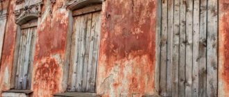
At this point, the Ilovlya River passes through the satellite of Kamyshin (the third largest city in the 34th region). It's called Petrov Val. We have already told you why. It would be more correct to say Shafts. After all, this is a whole low “ridge” - by order of the autocrat, the “draft” people living in dugouts managed to dig up tons of earth. Many, from backbreaking labor, gave their souls to God right here. Only in 1701 were the poor people left alone. Note that before Soviet times, Petrovy Vali was not properly populated. Beginning of urban settlement laid the foundation for the construction of the Volzhskaya Rokada during the Great Patriotic War. This railway line was built in 100 days (at this rate, structures are now being built exclusively in China). At first, workers used existing dugouts, and over time they installed above-ground dwellings. Of course, a station was installed. Stalin exiled the closest Germans away (only during the “Thaw” did some return). Then a highway passed here (exit from the highway connecting Kamyshin and Kotovo). As a result, over 13,000 people live here comfortably. In Petrov Val, the city-forming industry is the railway. In the central massif there is a steam locomotive, which is all overgrown with grass. This is a topiary in the style of Russian Railways (no other city in the country has anything like it). There is already an ordinary perfectly restored tractor in the depot. There is mediocre infrastructure and few private enterprises. Also from the tops of the Shafts (they stand a little to the side) you need to take a photo of the Kamyshinsky Ears. More about them.
In the east, the suburbs of the described municipality smoothly move to the foot of the Ears. This refers to a natural monument - an isolated fragment of the Volga Upland, separated from the main massif due to wind erosion. The slopes are sloping and rounded. The peaks end with massive geological formations in the form of blocks. There are 2 hills. And from a certain angle, their silhouettes resemble ears (“the head” is the ruin of the geological rise of Shishanki, on which both fragments of the natural monument stand). To the “eared” part of the described area there are primers from both Petrov Val and Kamyshin. The traveler will see imprints of ancient flora and fauna on stone blocks or take photographs of Petrovy Vali from here.
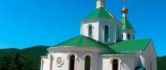
Convent in Gusevka
Here we also suspend rafting on the Ilovlya River. It was in the presented village that the avant-garde artist Petrov-Vodkin wrote his famous “Bathing of the Red Horse”. Because these places are idyllic. The historical “business card” is the women’s monastery of the Akhtyrskaya Mother of God icon, founded by the wife of the Persian chieftain of the Volga Cossacks. This is a completely restored complex (of all the religious objects of the 34th region in beauty it is second only to the famous temple in Serafimovich). In addition, this ensemble is both a garden and a flower garden (if you don’t believe me, come – everything here is very reminiscent of a botanical farm!). You can take part in the service, and then (after tasting the pears straight from the tree) rinse off in a special indoor bath (a holy spring, located in a hut-well). The guide will tell you about the imperious but “pious” character of the chieftain, who was buried (like all nuns) right in the monastery courtyard. Ilovlya on the Gusevsky banks blooms with exquisite water lilies. Local residents are fascinated by the nature of the village and at the entrance to it they placed a patriotic poem on a stand. Speaking about the natural arboretum, we emphasize: it is the same as the one in the interfluve with Olkhovka.
District center Olkhovka
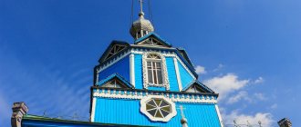
Here, at the mouth of the small Olkhovka River, relaxation on the Ilovlya River makes clear sense. In the reservations subordinate to the municipality of the same name, the floodplain finally begins. Although the widest area is described below. The river “touches” the southern part of the settlement indicated in the title. It first appeared on the map in 1718. However, the first old-timers told officials back in that year: they didn’t come for nothing. Most likely, as in the “pechers”, fugitive peasants or Old Believers of various ranks settled here. Since the Elizabethan era, peasants from different provinces were resettled here, exchanged for purebred hunting dogs. Therefore, the genes of the local population contain the blood of residents of different European corners of the then Russian Empire. The first feature of Olkhovka is its proximity to both the monastery in Kamenny Brod and the nunnery (in Gusevka). This point on the map seems to be between them. It has a railway station Zenzevatka (the other side of Ilovlya) and a platform for intercity vehicles. The second tourist attraction is the location of the largest agricultural cooperative in the Volgograd region. Cows are bred and sold there. Makar the Persian lived directly here with his family (although the center of the Circle of the Volga Cossacks was located in Dubovka). When the ataman left for the Circle, he left an attorney. Tom had to receive all sorts of ambassadors. Fields and gardens expanded. And so Posad was born from the village. The third reason to be in Olkhovka is the Church of the Intercession of the Blessed Virgin Mary. It's a wonderful building. It should be included in the pilgrimage program. The nearby landscapes evoke delight - the tangled wooded oxbows of Ilovlya and many tiny ponds.
Forest reserve "Ilovlya-Olkhovo interfluve"
The next stop on the Ilovlya River should take place in some episode of this amazing location. It is the largest and most interesting. People dubbed it “Chalk Mountains in Ilovlya”. Let's start with the fact that over these kilometers the “artery” finally becomes rich in dendroflora. The ravine has dense thickets of alder, silver poplar, willow and ash. Riot of sedge. This is a pleasant feature of the narrowing floodplain episode, stretching all the way to Pisarevka. Raising your head, against the background of the clear blue sky, the chalk hills shine with a dazzling silhouette (already on the elevated edge, where feather grass reigns). And on the water itself there is a water chestnut (chilim) and a water lily. Underwater there are algae. Only on this section of the water route can you constantly hear croaking.
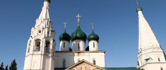
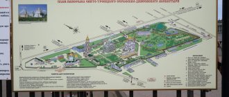
Next we are greeted by the former village of Goskonyushnya, and now the complex of the Trinity Belogorsky Kamenno-Brodsky Monastery (in tsarist times - a female monastery). The beauty sector is divided into 4 parts: the monastery courtyard, a relict oak grove, 3 holy underground springs of different composition, and also “pechers” (that’s what all cave temples are called in Church Slavonic). Enthusiastic people are brought here from Volgograd and Saratov
As for the passages, it turns out that the Ilovlya River is located opposite the man-made cavities of the Holy Mountain. This is a section of the chalk ridge, which is found at the entrance to the monastery. At a certain height. Some of the passages are still used as places of worship. Most are already closed (at one time several villagers went missing in them; the passages reach the villages). Like the oak trees that have been inventoried (the largest of them is already 150 years old), the pechers are shrouded in the largest number of tourist myths. There is not enough space to list them all here. The legend of one of the speleologists who published information that on one of the sections of the ancient passages he saw an ancient boat deserves curiosity (note that in ancient times the Slavs and Germans buried leaders in large boats). Venerable researchers claim that tunnels began to be dug back in the 9th century (the Slavic colonists thus protected themselves from the Turks). There is a version that during the Horde years Alexander Nevsky stayed here, en route to the Khan’s headquarters in order to redeem the most valuable part of the Russian army after another raid). And the very name of the Kamenny Brod tract is traced back to the real situation of the crossing of the princely detachment. Only one thing can be said with certainty.
When the area was returned to the Russians (at the beginning of the second half of the 18th century), the reservation attracted the attention of the wife of Makar of Persia, who set up another women’s monastery in it (on the walls of the caves the once-scratched women’s names are still visible - grooves in the chalk are visible on the soot from the candles). People are allowed into the altars for a “ridiculous” price.
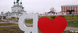
Regional center Ilovlya
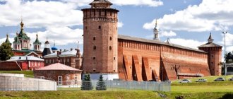
It would be nice to organize further anchorages on the Ilovlya River somewhere here. The first to greet tourists is the Cossack Kuren Museum. It looks impressive and authentic and is clearly visible from the M-6 highway (they are just a few meters away). The hydrological object to which the longread is dedicated “gave” a large fragment of the coast to this complex. Part of the ensemble is a Cossack farmstead (examine the existing economic buildings of the “middle peasant” Cossack). The indoor part of the exhibition is located in a building quite boldly but attractively stylized as a Don kuren. The guides of these halls will say that the paths of famous rebels went through Ilovlya: Stepan Razin, Emelyan Pugachev and Kondraty Bulavin. And at this moment you yourself will study household utensils, agricultural implements, furniture, folk costume, checkers and decorations of the local “Donets”. Their customs have slight differences from the classical culture of their neighbors (Rostov or Khoper village residents). Check out old photos and some documents. The main exhibit was recognized by most guests as a hut, built not from adobe, which was typical for the Cossacks, but from natural stone. And one more “highlight of the program”. A theatrical performance for organized visitors. It consists of a demonstration of Cossack rituals. During the process, you can taste traditional authentic dishes and drinks (the latter include the soup “sherba”, the sweet and sour dish “kulaga”, a healthy infusion and a special type of mead). In the vicinity of the same microdistrict (Krapivina) there is a rope park.
From here, an asphalt driveway leads visitors between rich and picturesque forest plantations directly to residential areas. What's in them? Brand No. 1 – Poklonny Stone, topped with a cross (this is where the settlement supposedly began). This work is located at the beginning of Zarechnaya Street, opposite the monuments to the Liquidators of the Chernobyl Chernobyl Nuclear Power Plant and the Warriors of Hot Spots. Such art objects are now available in many cities and towns. In second position is the Donskaya Church, well-made of white brick (known because opposite it is the local history center). There is a local theater on Krasnoarmeyskaya Street (third and last line of the rating).
Buffer zone of the Donskoy natural park
Rafting down the Ilovlya River brings “water workers” to heavenly places. From the ridge you can actually walk to a point from where you can see the highest chalk cliff of the Donskoy Natural Park - Mount Kobylya Golova. If you are on a motorboat, the journey will take literally 5 minutes. However, there are natural attractions at the mouth itself. Take, for example, the “Kachalinsky” island. He earned his popular nickname because of the excavations of the first Cossack town of Kachalinsky (modern Kachalino lies a little to the side). On the maps, the river isolate is designated as Razin Island (it is assumed that the Cossack rebel spent quite a lot of time here, personally participating in the life of the settlement). Moreover, the Kachalinsky town, which has sunk into oblivion, is considered by many to be the birthplace of the no less famous Ermak (a memorial stone with a cross was erected in his honor on the hill of present-day Kachalino - not far from the destroyed bell tower). So what is the island's brand? It is recognized as the largest natural river island in Europe. But because competitors who are larger than him were formed as a result of the construction of hydroelectric power stations or simply dams. But this is a different category of geographical objects. This entire piece of land is a continuous plot of land, overgrown along the edge with various types of reeds - cattail, reed, chagan and kuga. It is adored by fishermen and spearfishing fans. There are countless catfish, burbot, giant pike perch and huge pike here. You will have to fence the General's Bridge (also a kind of excursion point). And here he is, Don, whose beauty was mentioned at the beginning. It remains to add that in the swampy floodplain thickets of the outer side of the Malaya Donskaya Bend there were once many wild boars. The earth was much denser.
Literally 7-8 kilometers along the Don, in the immediate vicinity of the village of Krasnodonsky, farmer Igor Filippov breeds emus. Sometimes excursions are taken to the farm (both from Ilovlya itself and from Volgograd, Volzhsky and Kamyshin - in relation to them this is the closest ostrich ranch). The program is standard - we communicate with cassowaries, eat an omelet and buy an egg or feathers as a souvenir. And the farm is called Philip Straus.
Land of Gusevsky Monastery
A visit to the temple and other beauties of the monastery of the Akhtyrskaya Icon of the Mother of God costs 150 rubles. Behind the fence there is an impressive landscape design and unforgettable views of the facades. You cannot photograph the interior of the temple.
It’s immediately obvious that the monastery is for women – look how many flowers there are
On the opposite side of the territory we found a nice vegetable garden, a pear orchard
Vegetables are watered regularly, and the pears will soon be ripe
And even further we discovered a source with clean underground water (a well and an irrigation hut).
This is what the washing and drinking facilities look like. A well and a building where you can undress to douse yourself with blessed water. And then rub yourself. As soon as we showered ourselves and replenished our supply of useful water, we decided to head back.
Tourism and recreation on the Ilovlya River
The Ilovlya River is located in the arid zone of temperate climate. Completely in the steppe zone. Although in some places it has dense (but still narrow) areas of floodplain. The Ilovlinsky voyage is typically steppe. Horseback riding, autumn-spring jeeping or winter snowmobile racing, summer and winter fishing, rafting, kayaking or kayaking, search activities and pilgrimages. This is all the leisure time typical of the “Ilovlinsky” corners of the Russian Federation, open to all winds. It remains to add that the following routes lead to the river riviera: Volgograd-Samara (passes through the source), Kalininsk-Zhirnovsk-Kotovo-Kamyshin, Ilovlya-Kamyshin and M-6 “Caspian” (at the turn to the city of Ilovlya). A dozen intra-district (including dirt) roads approach the water's edge. Therefore, the banks of the presented water stream are a paradise for cyclists and trekkers. The railway track crosses the reservoir near the stations Rossosha, Petrov Val, Gusevka, Zenzevatka and Ilovlya.
Most of all, the Ilovlya River will delight fans of horse riding. There is an equestrian club in the town of the same name. Just like in Petrov Val. Air extreme sports are also available (in the last of these agglomerations you can skydive and paraglide). There is a rope park in the administrative center of the Ilovlinsky district.
Beach pastime is relevant everywhere. Even where the “baths” are herbal. Of course, the best spots have long been occupied by parking lots and recreation centers - “Our Turbaza”, “3 Pines” and the tourist stop “Zeleny Gai”. There is more sand at the bottom.
It’s not difficult to arrange an eventful and pilgrimage holiday on the Ilovlya River yourself. On the way you will come across many temples (including the remains of Old Believers). As for festivals, in the town of Ilovlya the main event is considered to be the equestrian festival “Donskaya Zluchina” (all riders must be dressed in Cossack clothes from different times). And in Petrov Val, Stille Nacht (“Silent Night”) is recognized as a long-awaited show...
Full rafting on the Ilovlya River is an excellent example of a 2-week leisure activity that will not cause you any inconvenience. Although extreme sports enthusiasts and lovers of deeper water will not choose the “sleepy” and shallow reservoir described. So, the trip begins at the mouth of Kamyshin (you can really get on the water right in Kamyshin - people come here from Volgograd, Saratov or Samara). According to the recently ennobled episode R-228. At the entrance there is a backwater, 1 riffle, many loops, rubble and beaver dams. The hydrological object is “lazy”. Even in shallow constrictions, the speed barely reaches 8 kilometers per hour. The stretches are generally 4 kilometers long. The water flow is considered wide and “streamless” on most sections of the route. The problem is caused by strong winds, infrequent water intake pipes, concrete spillway sluices and low-lying bridges in large rural municipalities. Another “symbol” of a water trip is a sufficient amount of dry wood (let us repeat that the floodplain is narrow and intermittent, but quite dense; there is enough brushwood for a campfire). But during fire months, video drones can fly. Carefully.
Fishing and hunting on the Ilovlya River
What kind of fish does the Ilovlya River lure tourists with? Fishing will introduce visitors to pike, crucian carp, perch, and ide. White bream, ram, pike perch, catfish, ruff and gudgeon. And sometimes the hook turns out to be carp, bream and topwater bleak (which is what the river predator likes to eat). Fishing from a boat is common. On the fairway you can catch both a chub and a large predator. Fishing is good everywhere on the Ilovlya River. Just avoid getting caught with gear in the buffer water protection zones of the Donskoy Natural Park (there are spawning pits in some creeks here). Do not forget that fishing on the Ilovlya River will lead to the capture of ichthyofauna from the Red Book of Russia - sculpin, Ukrainian lamprey and representatives of sturgeon species. They must be released back immediately. And further. In snags (and the river “body” is famous for it) only a short cast is possible. The river basin in several places predisposes to the riot of voracious perch...
Having talked about the bounty of the Ilovlya River, let’s leave fishing alone. Guests will also be attracted to the Ilovlinsky shores by hunting. First of all, otter and beaver (their presence is indicated by rubble inside the riverbed). The river is famous for its hare, wild boar, steppe polecat and jerboa. There is a wolf (free) and a fox - typical inhabitants of the steppe. They say that a marten has appeared in the local copses more than once. Sometimes a wolverine comes across. There are no larger mammals due to the absence of “indigenous” forests, groves or oak forests. Meadow and swamp-lake hunting makes much more sense. Autumn fishing is especially successful. There are no forbidden areas. In fact, everything that does not belong to the residential sector is a hunting ground. Duck, woodcock and goose are waiting for you. And in the floodplain and in the steppe there are “classic” partridge and quail. Do not forget that all owls, cranes, herons, swans and storks are recorded in the Red Book (they live in especially overgrown creeks and in oxbow lakes near the riverbed). Predators - all of them - are recognized as endangered birds. The local open tracts and chalk peaks are inhabited by burial mounds (buzzards) and white-tailed eagles. No “red books” appeared among the land animals of Ilovlya.
Kamenno-Brod "pechers"
A porch leading to cave chapels with cells. Previously, they were part of the women's monastery (they began to belong to men after reconstruction - in the 90s)
During the ascent, the entire floodplain “arboretum” was filmed with a view of the monastery premises.
A typical panorama of the very center of the Volgograd region - floodplain in the steppe
Inside, all the walls are scratched with inscriptions. These are women's names. After all, nuns lived here most of the time. Although the first catacombs (IX century) were for everyone
As I mentioned, the passages have iconostases, inscriptions and niche cells along their length...
This is what one of the many altars looks like.
A separate recreation area on the first floor (the lower 2 are closed to visitors, people from the villages disappeared there) leads to the chapel of St. Nicholas. A monk guide tells a brief history of this saving Orthodox tract, in which the Slavs lived continuously from the 9th century to 1918 (the Bolsheviks drove out the believers from here, and turned the above-ground buildings into stables). The total length of the branches is 200 m. And the temperature is no hotter than 12°C.
After visiting the passages in the Holy Mountain, the 2nd part of the tour began - a hike to 3 consecrated springs (lying right next to a grove of 100-year-old oak trees). Here you can drink and swim... Which our couple took advantage of with pleasure, filling a lemonade bottle.
Springs with silver, radon and hydrogen sulfide (at the last bath)
The “grove” consisted of only 8 oak trees. But they were colossal in size. And everyone is signed.
The most gigantic oak tree. He is not 100, but about 150 years old. I also saw Alexander III
Protection of the Ilovlya River
The protection of the Ilovlya River concerns only the beginning of its path (Saratov lands), as well as the coasts of such Volgograd agglomerations as Olkhovka and Petrov Val (high agricultural load gives class IZ: “moderate pollution”). And, conversely, the Ilovlinsky district (including its administrative center) is still one of the models of environmental well-being in the 34th region. The protection of the Ilovlya River in its lower reaches currently involves bank protection. During floods, the southern settlements of the settlement of Ilovlya and neighboring lands are subject to slight erosion. There is also a fight against unauthorized installation of dams by entrepreneurs.
This description of the Ilovlya River gives you the right to choose the type of river recreation you like most. And this could be a water trip with fishing and swimming, a weekend historical pilgrimage tour, an extreme jeep trip or a real horseback riding trip (feel like a Scythian, Sauromatian, Burtas and Cossack). The water “road” is far from the dirtiest resource in the Southern Federal District. Enjoy it.
Road to Gusevsky Monastery
Nothing else delayed us in the cult space of the village of Kamenny Brod. We drove onto the Olkhovka-Kamyshin highway. On the road we passed a few residential and commercial buildings of the above-mentioned village and the wooded Olkhovka River.
On the way there were several intersections with the Ilovlya-Petrov Val railway line
The turn to the village of Gusevka is both a railway platform and a bus stop.
From here train or intercity bus passengers get to Gusevka
The entrance to the village is marked by crossing the next bridge over Ilovlya and a stand.
There is a road sign. Water lilies also live in this section of the river bed.