About the history of the city
The upper reaches of the Don were inhabited by people in immemorial, prehistoric times. This is evidenced by finds from archaeological excavations, which can be seen in the historical and memorial museum complex of the city of Donskoy - “Bobriki”.
The first mention of a Russian settlement in the vicinity of the city of Donskoy in written sources dates back to 1571. We are talking about a repair (i.e., a newly built village or farm) of Khodyrev, at the mouth of the Bobrik River. The river got its name from the beavers that lived in it in those days. The local hill was named after Bobrik Mountain, and the new village of Boboriki, and in general the entire surrounding area: Bobriki County.
In the first quarter of the 18th century. On the orders of Peter I, the Ivanovo Canal was built here to connect the Volga and Don. Up to 20 thousand peasants were brought from all over Russia to build it. They deepened and expanded Ivan Lake and built high earthen ramparts along the banks of the canal. The canal was 25 m wide, 1.5 m deep and 13 kilometers long - from the village of Bobriki to the Lyubovka River. To raise the water on the canal, 33 locks were built. The canal worked for several years, but was then abandoned due to lack of water and new grandiose projects of the restless emperor.
In 1773-1776. A rich noble estate was built on Bobrik Mountain for Catherine II’s illegitimate son Alexei, whom she gave birth to in 1762 from her favorite Grigory Orlov. According to land ownership, the empress's son received the surname Bobrinsky and became the founder of the count family of the same name.
His descendants owned sugar and distillery enterprises in the area of the present city of Donskoy; and when coal mining began here in 1883, then in coal mines. Since the end of the 19th century, during these developments, a mining settlement was formed.
Monument to miners at the entrance to Bobrik Mountain
In 1929, it received from the new government of workers and peasants the official name “workers’ village of Donskoy”. And in 1939 - the status of a city.
At the end of November 1941, Donskoy was captured by the German occupiers, but they only held out in the city for a couple of weeks.
Until the early 1960s, until coal deposits were exhausted, Donskoy was a mining town. Two large coal trusts operated there. After the development was completed, people were employed in a different way: furniture, shoe and hosiery factories, a reinforced concrete structures plant, and an experimental coal engineering plant were opened in Donskoy. In the early 70s, 2 new high-tech, at that time, electronics factories were built in Donskoy.
In 1962-1964. the city of Donskoy was gasified.
Since 2005, the city, as its microdistricts, includes the city of Severo-Zadonsk (former mining village 13th kilometer) and the small working villages of Podlesny, Rudnev, Novugolny, Komsomolsky, Shakhtyorsky, Zadonye.
Since 2002, the city of Donskoy has its own coat of arms and a similar flag. The family coat of arms of the Bobrinsky counts was taken as a basis for their creation. The official symbol of the city depicts two beavers, a count's crown and a pickaxe - as a sign of respect to the mining past. In Soviet times, the city did not have an official coat of arms, but the icons depicted a coal mountain, a semicircle of a mechanical gear and a broken line - a symbol of electricity. And also the date of formation of the city: 1939.
Territorial structure of Donskoy
The municipal formation “city of Donskoy” consists of 8 microdistricts:
- Central. It is located in the historical center of the city, stretched meridionally along the railway line. It houses the city's administrative buildings, shops and residential buildings. There is an industrial zone.
- Severo-Zadonsk. Located in the northeastern part of Donskoy, until 2005 it was a separate city. They are a fully landscaped village with all the necessary infrastructure. The street layout is rectangular, the buildings are predominantly multi-storey, but there is also a private sector.
- Podlesny. A village in the southern part of the city with completely private residential buildings. Previously, there was a hosiery factory and a plant for repairing mine equipment.
- Rudnev. Located near a forest, during the development of the coal industry the Ushakovsky coal mine and mine worked here. There are both private and multi-storey buildings.
- Novugolny. It is located in the north of Donskoy and is closely adjacent to the neighboring city of Novomoskovsk. It is the industrial center of Donskoy.
- Shakhtarsky. A large village in the southern part of the city, formed in 1954 at mines No. 42, No. 45 and No. 46.
- Zadonye. The city's smallest microdistrict in terms of population (1,400 people). Located south of another microdistrict, Severo-Zadonsk.
- Komsomol. The most remote area of the city is located on the southern border of the Don municipality. During the Soviet years, coal mining was carried out here. All buildings are one- and two-story.
The area of the urban district is 5981.5 hectares.
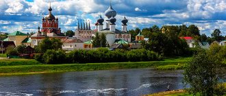
Historical and memorial museum complex "Bobriki"
This is the main attraction of the city, the municipal museum on Bobrik Gora. It is located in the few surviving buildings of the estate of the Bobrinsky counts (most of them were dismantled for building materials).
The huge palace itself, the maintenance of which was expensive for the descendants of Catherine II’s illegitimate son, was completely dismantled back in the 1840s, and its bricks were sent to the sugar and distillery factories. All that was left were two outbuildings that have survived to this day, and a small one-story house where the Bobrinskys stayed during their summer visits to the village of Bobriki. This house existed until 1955. Then it burned down, and a children's sanatorium was built in its place.
The luxurious three-story palace, 110 meters long, was built in vain in the province: the son of the first Count Bobrinsky decided to dismantle it as unnecessary.
Historical and memorial museum complex "Bobriki" in the wings of the former estate
The current museum complex includes a local history exhibition, the Orthodox Church of the Transfiguration (in Soviet times, from 1940 to 1991, it housed a planetarium), the family tomb of the Bobrinsky counts (built in the early 19th century) and a manor park.
As a cultural institution, the historical and memorial museum complex dates back to 1933, when it was founded as a museum of the Moscow Region Coal Basin. The collections of this museum complex include more than 26 thousand storage units.
There are such artifacts as timber from the sluice gates of the Ivanovo Canal; memorial collection of representatives of the Bobrinsky family; archaeological finds (bones of ancient animals; stone axes, objects from the village of the Vyatichi Slavs of the 13th-14th centuries); exhibits and reconstructions on the history of coal mining in the region; lifetime editions of the works of the founder of theoretical cosmonautics, Konstantin Tsiolkovsky, documents and personal belongings of the Red commander during the Civil War, Nikolai Rudnev (1894-1918), a native of these places, who died near Tsaritsyn in a battle with the Cossacks. The museum has a cinema hall, a lecture hall, an archive and a scientific library.
A fragment of a museum exhibition dedicated to the work of miners
The guides conduct a comprehensive tour: acquaintance with museum exhibitions and a walk around the estate. Master classes, interactive programs, and folklore festivals are held.
Address of the museum complex: st. Krasnoarmeyskaya, 9.
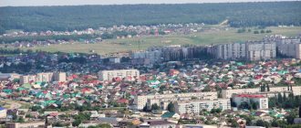
Donskoy housing stock
The bulk of the residential buildings in the modern city were built between 1956 and 1967. During the heyday of the coal mining industry in the vicinity of Donskoy. But there are also new buildings. In the center, for the most part, there are buildings with two to four floors. Five-story buildings are a rarity in the city. Multi-storey microdistricts are located in the area of Novaya, Zavodskaya, Voroshilov, Molodtsova streets.
In other areas of the city, almost the same picture is observed. Only priority is given to the private sector. One-story houses are located, for example, along Kirova, Narkomovskaya, Novomoskovskaya and Proletarskaya streets.
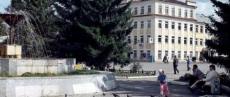
House of Culture named after Vladimir Molodtsov
The magnificent House of Culture, designed in the style of Stalinist architecture, was built in the difficult post-war years. It opened in 1951 and was called "Shakhtostroitel". For that time it was a real palace - a snow-white building with classical columns, a beautiful auditorium, and a spacious foyer with a vaulted ceiling. Amateur art groups, a choir, and a brass band immediately started working here. Concerts were held in the auditorium on holidays, and film shows on ordinary days. At dances in the cultural center, Donetsk residents met and relaxed, talked and fell in love. Many married couples began their history together under his roof.
In 1963, the Shakhtostroitel House of Culture became simply “Stroitel”: the coal in the area ran out, and the House of Culture was transferred to Stroytekhnika.
In 1966, in connection with the 55th anniversary of the birth of Hero of the Soviet Union Vladimir Molodtsov, the House of Culture was given a name. Before the war, Molodtsov worked as a miner in local coal mines. From July 1941 to July 1942, he led a partisan detachment based in the catacombs of Odessa and carried out sabotage attacks on the Romanian occupiers. He was captured and killed by the Nazis.
House of Culture named after Vladimir Molodtsov
In 1988, the Molodtsov House of Culture was transferred to the Don Leather Goods Factory, and in 1996 it became municipal property. In the early 2000s, the Koshevoy Palace of Culture and the Ostrovsky Palace of Culture - Houses of Culture in other microdistricts of the city of Donskoy were annexed to it as branches.
The House of Culture survived the “dashing 90s” and is still open to everyone who loves songs and dances; theatrical, decorative and applied arts.
The central entrance to the building is still decorated with statues of miners. The stadium in the city of Donskoy is also named after Vladimir Molodtsov.
DK address: st. Oktyabrskaya, 91.
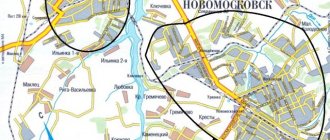
Routes on the map of Donskoy. Transport infrastructure
M-4 Don , runs 20 km from the city .
There is no airport in Donskoy.
The Bobrik-Donskoy railway station is located in the city center, on Privokzalnaya Street, 23. Trains operate from it on the routes Karaganda - Baranovichi, Kaliningrad - Chelyabinsk. Suburban trains also run on the routes Aleksin - Urvanka, Ryazhsk-1 - Uzlovaya-1, Urvanka - Tula, Ozherelye - Uzlovaya-1 and others.
From the Donskoy bus station, intercity flights depart from Tula - Kimovsk, Efremov - Novomoskovsk, Moscow - Kimovsk. On the satellite map of Donskoy, the bus station is located in the central part of the city, on Oktyabrskaya Street, 48.
The city's public transport is represented by 10 city bus routes. The general condition of city buses is good; new models of buses have recently been purchased, but old PAZs and minibuses still run around the city. The fare for them is 20 rubles.
Church of the Transfiguration
The Orthodox church, built in the 1770s and consecrated in 1778, is part of the buildings of the Bobriki estate complex on Bobrik Mountain.
This is a very beautiful place in the Central Russian Upland - a gentle hill surrounded by green trees, bordered by two rivers - the Don and Bobrik.
Church of the Transfiguration
On it, since the 16th century, there was a wooden church of St. George, which belonged to the repair of Khodyrev (and then to the village of Bobriki). On the site of this dilapidated temple, a new stone one was built. It was founded in the spring of 1774 and received the name of the Icon of the Savior Not Made by Hands.
In the early 1930s, by decision of local authorities, the temple building was seized from the Russian Orthodox Church. Its bell tower was dismantled and its property was looted. In 1937-1940 a planetarium (the second in the USSR) was built under the temple dome. It worked until 1991, when it was decided to return the temple to the Russian Orthodox Church.
Church of the Transfiguration inside
Address: Sovetskaya Square, 5.
Museum of Local Lore
There is a local history museum in one of the estate buildings. There are a lot of different exhibits here. This includes furniture from the Bobrinsky estate, and household items, and ancient books, documents, photographs, and models of mines, and dishes, and paintings, and much more. In general, a most interesting place that can tell the history of this area better than people.
Tomb of the Bobrinsky family
After the death of the first Count Bobrinsky, the same son of the Empress (he died in 1813), his wife decided to bury him in the far part of the park. In 1815, they began to build a family tomb there. Subsequently, representatives of the first, second and third generations of the Bobrinsky counts were buried in its crypt.
The burial vault was designed to accommodate burials downstairs in the crypt and memorial services to be held in the chapel above.
The architectural style of the tomb can be called simple and strict. The building's circumference is surrounded by paired semi-columns with Doric capitals pressed against the wall, and the piers between them are cut by rectangular shallow niches. 8 windows with metal bars are edged with a profile frame. The brick walls of the building are lined with white stone, from which the decor is also laid. Previously, a semicircular staircase with a wide platform, fenced with round pillars and an iron decorative lattice, led to the mausoleum.
Tomb of the Bobrinsky family
In September 1921, the tomb was looted, and the coffins were buried in a common pit nearby. The building stood abandoned for many years. Mountains of garbage and sewage formed inside. In the 90s, entrepreneur-enthusiast Nikolai Pochuev received permission from the authorities to preserve the tomb, with the help of caring people he cleared it of debris, blocked the opening, hung shutters, made a gate, installed a cross, and covered the roof. In 2003, the remains of the Bobrinskys were again reburied back into the crypt. The tomb was recognized as an architectural monument.
Location: Shakhtyorsky Park.
Notes
- ↑ 123
www.gks.ru/free_doc/doc_2016/bul_dr/mun_obr2016.rar Population of the Russian Federation by municipalities as of January 1, 2016 - THE USSR. Administrative-territorial division of the union republics on January 1, 1980 / Compiled by V. A. Dudarev, N. A. Evseeva. - M.: Publishing house "Izvestia of the Soviets of People's Deputies of the USSR", 1980. - 702 p. — P. 231.
- ↑ 12345678910
www.MojGorod.ru/tuljsk_obl/donskoj/index.html People's encyclopedia “My City”. Donskoy (Tula region) - [demoscope.ru/weekly/ssp/rus59_reg2.php All-Union Population Census of 1959. The size of the urban population of the RSFSR, its territorial units, urban settlements and urban areas by gender] (Russian). Demoscope Weekly. Retrieved September 25, 2013. [www.webcitation.org/6GDOghWC9 Archived from the original on April 28, 2013].
- [demoscope.ru/weekly/ssp/rus70_reg2.php All-Union Population Census of 1970 The size of the urban population of the RSFSR, its territorial units, urban settlements and urban areas by gender.] (Russian). Demoscope Weekly. Retrieved September 25, 2013. [www.webcitation.org/6GDOiMstp Archived from the original on April 28, 2013].
- [demoscope.ru/weekly/ssp/rus79_reg2.php All-Union Population Census of 1979 The size of the urban population of the RSFSR, its territorial units, urban settlements and urban areas by gender.] (Russian). Demoscope Weekly. Retrieved September 25, 2013. [www.webcitation.org/6GDOjhZ5L Archived from the original on April 28, 2013].
- [demoscope.ru/weekly/ssp/rus89_reg2.php All-Union Population Census of 1989. Urban population]. [www.webcitation.org/617x0o0Pa Archived from the original on August 22, 2011].
- [www.perepis2002.ru/ct/doc/1_TOM_01_04.xls All-Russian Population Census 2002. Volume. 1, table 4. Population of Russia, federal districts, constituent entities of the Russian Federation, districts, urban settlements, rural settlements - regional centers and rural settlements with a population of 3 thousand or more]. [www.webcitation.org/65AdCU0q3 Archived from the original on February 3, 2012].
- [www.gks.ru/bgd/regl/B09_109/IssWWW.exe/Stg/d01/tabl-21-09.xls Number of permanent population of the Russian Federation by cities, urban-type settlements and districts as of January 1, 2009]. Retrieved January 2, 2014. [www.webcitation.org/6MJmu0z1u Archived from the original on January 2, 2014].
- [tulastat.gks.ru/wps/wcm/connect/rosstat_ts/tulastat/resources/32a53b80412060b2ac62ef367ccd0f13/Number+and+location+of+%28Volume+1%29.pdf All-Russian Population Census 2010. Number and distribution of the population of the Tula region]. Retrieved May 18, 2014. [www.webcitation.org/6PfOFQt4l Archived from the original on May 18, 2014].
- www.gks.ru/dbscripts/munst/munst70/DBInet.cgi?pl=8112027 Tula region. Estimated resident population as of January 1, 2009-2013
- [www.gks.ru/free_doc/doc_2012/bul_dr/mun_obr2012.rar Population of the Russian Federation by municipalities. Table 35. Estimated resident population as of January 1, 2012]. Retrieved May 31, 2014. [www.webcitation.org/6PyOWbdMc Archived from the original on May 31, 2014].
- [www.gks.ru/free_doc/doc_2013/bul_dr/mun_obr2013.rar Population of the Russian Federation by municipalities as of January 1, 2013. - M.: Federal State Statistics Service Rosstat, 2013. - 528 p. (Table 33. Population of urban districts, municipal districts, urban and rural settlements, urban settlements, rural settlements)]. Retrieved November 16, 2013. [www.webcitation.org/6LAdCWSxH Archived from the original on November 16, 2013].
- [www.gks.ru/free_doc/doc_2014/bul_dr/mun_obr2014.rar Table 33. Population of the Russian Federation by municipalities as of January 1, 2014]. Retrieved August 2, 2014. [www.webcitation.org/6RWqP50QK Archived from the original on August 2, 2014].
- [www.gks.ru/free_doc/doc_2015/bul_dr/mun_obr2015.rar Population of the Russian Federation by municipalities as of January 1, 2015]. Retrieved August 6, 2015. [www.webcitation.org/6aaNzOlFO Archived from the original on August 6, 2015].
- taking into account the cities of Crimea
- [www.gks.ru/free_doc/doc_2016/bul_dr/mun_obr2016.rar Population of the Russian Federation by municipalities as of January 1, 2016. Table “31. Population of cities and towns by federal districts and constituent entities of the Russian Federation as of January 1, 2016.” RAR archive (1.0 MB)]
- Official website: www.szez.ru
- Official website: www.emzdon.ru
- Official website: aeroem.ru
- [www.parra.ru PARRA.RU - Home]. www.parra.ru. Retrieved September 21, 2015.
- Official address: www.dokofa.ru
- Official address: mariorioli.ru
- Official address: www.parcom.ru
- [donskoj.city-banks.ru/ Banks of the city of Donskoy]. donskoj.city-banks.ru. Retrieved November 1, 2012. [www.webcitation.org/6BvZeY2C9 Archived from the original on November 4, 2012].
- [www.museum.ru/M2324 Historical and memorial museum complex “Bobriki” (Donskoy)]. Museums of Russia (05/07/2009). Retrieved March 7, 2011. [www.webcitation.org/61Al3cjV0 Archived from the original on August 24, 2011].
ZIS-3 gun
The memorial complex was opened on December 10, 1971, to commemorate the 30th anniversary of the liberation of the city from fascist invaders. In its center, a 76-mm ZIS-3 cannon is installed on a pedestal, on the left there is a stele with the dates of the Great Patriotic War: 1941-1945, and the words: No one is forgotten, nothing is forgotten, on the right there is another stele on which a banner with a military theme is attached .
ZIS-3 gun
Location: st. Herzen.
Social sphere
The social sphere has received significant development. In cities and towns, the DMO operates: 3 city and 1 children's hospital, a dental clinic, an ambulance station, a children's sanatorium, an outpatient clinic and a maternity hospital, there are 5 hospitals with a number of beds of 845. Classes are conducted in 16 secondary schools and one secondary gymnasium, there are 20 preschool institutions, 6 additional education institutions, a correctional boarding school, 4 vocational schools, 2 technical schools, 7 cultural centers, 2 music schools, 2 sports centers with swimming pools.
Monument "Two Warriors"
The memorial to the heroes of the Great Patriotic War was erected in 1969 on the site of a mass grave of Soviet soldiers. This is a sculptural group of two Red Army soldiers. One is depicted in an overcoat, the other in a padded jacket, with a PPSh machine gun.
Monument "Two Warriors"
Location: Bobrik-Gora microdistrict.
Main streets of Donskoy
- St. Oktyabrskaya is the central and longest street of the city, crossing it from east to west. Its beginning is located in the Donskoy industrial zone, and the end coincides with the western border of the city. It houses the city administration, Lenin Square, the stadium and the park named after. V.A. Molodtsova, supermarket chain "Magnit".
- St. Gornyatskaya is a suburban street in the eastern part of Donskoy. On both sides there is a private sector, and the logical continuation of this street leads to the neighboring city of Kimovsk (12 km).
- St. Pionerskaya is the main street of the Bobrik-Gora microdistrict. The following buildings have its name in the address: WWII memorial, Sovetskaya Square.
- St. 30 Let Pobedy is a continuation of Pionerskaya Street, connecting the village of Bobrik-Gora with the Central microdistrict. It houses a boarding school and a hospital complex. On the map of Donskoy with streets and houses you can see that on one side there is a private sector, and on the other there are apartment buildings.
- St. Pervomaiskaya is a street in the Novugolny microdistrict, passing near a forest and an industrial zone. Along it there is a monument “Cannon” and a monument to the heroes of the Second World War.
Memorial "Soldier and Mother" on Lenin Square
A sculptural group consisting of statues of a grieving mother and a bare-headed warrior was also installed in 1969, and also at the burial site of Soviet soldiers killed in the battles near Donskoy.
Memorial "Soldier and Mother" on Lenin Square
Nearby, the names of city residents who laid down their lives for their Motherland in the battles of the Great Patriotic War are engraved on black stone slabs.
Location: pl. Lenin.