Kursk
(Kursk region)
OKATO code:
38401
Founded:
1095
City since:
1095 City of regional subordination
Center:
Kursk region
Center:
Kursk district
Urban districts, population as of 01/1/2021
| Railway | Seimsky | Central |
| Telephone code (reference phone) | |
| 4712****** | 56-13-13 |
| 47122***** | 21-3-13 |
Deviation from Moscow time, hours:
0
Geographic latitude:
51°43′
Geographic longitude:
36°11′
Altitude above sea level, meters:
200 Sunrise and sunset times of the Sun and Moon in the city of Kursk
Note to pilgrims
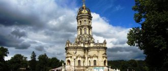
In the heart of the ancient city there is the Znamensky Cathedral, which is significant for Kursk residents and interesting for guests. The temple was repeatedly destroyed, rebuilt, and even used as a cinema. Today the cathedral has been completely restored, and, like 200 years ago, continues to impress with the splendor of its architecture and the grandeur of its bell tower.
Not far from the main square of Kursk, stands a building atypical for the city - the Roman Catholic Church of the Assumption of the Blessed Virgin Mary. It is made in a neo-Gothic architectural style, curious on the outside, educational on the inside. Coming here, you can listen to organ music or a church service and admire the beautiful view of the city.
Map
| Kursk: maps |
Kursk: photo from space (Google Maps) Kursk: photo from space (Microsoft Virtual Earth)
| Kursk Nearest cities. Distances in km. on the map (in brackets along roads) + direction. Using the hyperlink in the distance , you can get the route (information courtesy of the AutoTransInfo website) | |||
| 1 | Pryamitsyno | 18 (23) | SW |
| 2 | Medvenka | 35 (45) | YU |
| 3 | Kurchatov | 37 (44) | Z |
| 4 | Zolotukhino | 41 (51) | WITH |
| 5 | Fatezh | 46 (50) | NW |
| 6 | them. Karl Liebknecht | 51 () | Z |
| 7 | Solntsevo | 52 (61) | SE |
| 8 | Shchigry | 53 (58) | IN |
| 9 | Oboyan | 57 (70) | YU |
| 10 | Lgov | 63 (75) | Z |
| 11 | Konyshevka | 63 (95) | Z |
| 12 | Bolshoye Soldatskoye | 64 (84) | SW |
| 13 | Tim | 65 (63) | IN |
| 14 | Ponyri | 65 (81) | WITH |
| 15 | Pristen | 65 (83) | SE |
| 16 | Manturovo | 71 (88) | SE |
| 17 | Ivnya (Belgorod region) | 74 (93) | YU |
| 18 | Cheremisinovo | 76 (81) | IN |
| 19 | Maloarkhangelsk | 77 (234) | WITH |
| 20 | Kolpna (Oryol region) | 79 (208) | NE |
| 21 | White | 82 (108) | SW |
| 22 | Trosna (Oryol region) | 84 (91) | WITH |
| 23 | Prokhorovka (Belgorod region) | 86 (147) | SE |
| 24 | Glazunovka (Oryol region) | 86 (219) | WITH |
| 25 | Zheleznogorsk | 87 (108) | NW |
| 26 | Suja | 87 (111) | SW |
| 27 | Dmitriev | 88 (145) | NW |
| 28 | Korenevo | 95 (143) | Z |
| 29 | Dolgoe (Oryol region) | 97 (168) | IN |
| 30 | Troitsky (Belgorod region) | 100 (107) | SE |
a brief description of
Located on the Central Russian Upland, on the banks of the river. Seim and its tributary Tuskar, 536 km southwest of Moscow. Railway node Highway.
In 1970, Kursk was included in the list of historical cities of Russia. The urban planning value of its heritage is assessed at the regional level. In 2010, it was excluded from the list of historical cities.
The climate is moderate continental. Average temperatures in January are -8, July are +19. Precipitation is about 500 mm per year.
Territory (sq. km): 189
Information about the city of Kursk on the Russian Wikipedia site
Historical sketch
It was first mentioned in the Life of Theodosius of Pechersk (not earlier than 1036, when the Dnieper left bank came into the possession of Yaroslav the Wise). The first chronicle mention is under 1095 as Kursk. Name by location at the confluence with the river. Tuskar of the Kur stream. The hydronym is associated with the popular term kurya - “a river bay, a narrow channel of the river, The Tale of Igor’s Campaign.” In 1287-93. in the Kursk “principality” there was an uprising against the Baskak Akhmat.
From 1360 to the end of the 15th century. Kursk was part of the Grand Duchy of Lithuania.
In the 16th-17th centuries. a city of the Moscow State on the borders with the Polish-Lithuanian Commonwealth and the Wild Field. In 1596 a new fortress was built. At the beginning of the 17th century. Kursk was repeatedly attacked by Polish-Lithuanian troops, Crimean Tatars, and Nogais.
In 1708 assigned to the Kyiv province, from 1719 in the Belgorod province. Since 1727 - in the same province of the Belgorod province. Since 1779, the center of the Kursk governorship (since 1796 - Kursk province).
The main event of the city was the annual religious procession from the Znamensky Monastery (founded in 1612) to the Korennaya Hermitage, next to which the Korennaya Fair arose, one of the largest in the country (transferred to Kursk in 1878).
In 1856, in the provincial city of Kursk, Kursk province, there were 24 churches, 2,575 houses, 500 shops.
Since the late 1860s. Kursk is a railway junction. At the end of the 19th century. Kursk is a large industrial center.
In 1932, the village of Yamskaya Sloboda (PGT since March 25, 1929, 15.6 thousand inhabitants, 1931) became part of Kursk.
Since 1934 the center of the Kursk region. In 1939, Streletskaya Sloboda (9.4 thousand inhabitants, 1939) and Kozatskaya Sloboda (9.6 thousand inhabitants, 1939) became part of Kursk.
Kursk was occupied by Nazi troops on November 4, 1941. It was liberated on February 8, 1943 by troops of the Voronezh Front during the Kharkov operation. The city was severely destroyed. The Battle of Kursk, which took place July 5 - August 23, 1943 on the so-called. The Kursk Bulge was decisive in ensuring a radical change during the Great Patriotic War of 1941-45.
Municipal indicators
| Index | 1990 | 1999 | 2001 | 2003 | 2005 |
| Demography | |||||
| Number of births, per 1000 population | 12.9 | 7.7 | 8.7 | 9.7 | 9.9 |
| Number of deaths, per 1000 population | 9.4 | 13.1 | 14.4 | 15.9 | 15.2 |
| Natural increase (decrease), per 1000 population | 3.5 | -5.4 | -5.7 | -6.2 | -5.3 |
| Standard of living of the population and social sphere | |||||
| Average monthly nominal accrued wages, rub. | 0.27 | 1289.5 | 2410 | 4132.7 | 6439.8 |
| Average housing area per inhabitant (at the end of the year), sq.m. | 15.1 | 17.5 | 18.3 | 20.1 | 21.2 |
| Number of preschool institutions, pcs. | 135 | 79 | 76 | 71 | 71 |
| Number of children in preschool institutions, thousand people | 24.4 | 11.7 | 11.9 | 11.9 | 12.3 |
| Enrollment of children in preschool educational institutions (at the end of the year), as a percentage of the number of children of the corresponding age, % | 58 | 58.6 | |||
| Number of daytime educational institutions (at the beginning of the school year), pcs. | 61 | 67 | 67 | 67 | 67 |
| Number of students in daytime educational institutions, thousand people | 54.4 | 57.2 | 52.3 | 47.5 | 42 |
| Number of doctors, people. | 2987 | 3675 | 3778 | 3374 | 3897 |
| Number of nursing staff, people. | 4924 | 5704 | 5635 | 5351 | 6041 |
| Number of hospital institutions, pcs. | 22 | 21 | 22 | 21 | 21 |
| Number of hospital beds, thousand units | 6.2 | 5.1 | 5.3 | 5.5 | 5.4 |
| Number of medical outpatient clinics, pcs. | 61 | 58 | 63 | 73 | |
| Capacity of medical outpatient clinics, visits per shift, thousand units. | 9.6 | 12.6 | 13 | 12.7 | 12.1 |
| Number of registered crimes, pcs. | 3752 | 8803 | 8094 | 6476 | 10715 |
| Persons who committed crimes were identified, persons. | 1619 | 3834 | 3058 | 2545 | 2604 |
| Economy, industry | |||||
| Number of enterprises and organizations (at the end of the year), pcs. | 8010 | 9741 | 11393 | 13108 | |
| Number of operating enterprises by type of activity: mining (at the end of the year), pcs. | 1 | ||||
| Number of operating enterprises by type of activity: manufacturing (at the end of the year), pcs. | 326 | ||||
| Number of operating enterprises by type of activity production and distribution of electricity, gas and water (at the end of the year), pcs. | 61 | ||||
| Volume of shipped goods of own production by type of mining (in actual prices), million rubles. | 1.1 | ||||
| Volume of shipped goods of own production by type of manufacturing (in actual prices), million rubles. | 19367.6 | ||||
| Volume of shipped goods of own production by type of production and distribution of electricity, gas and water (in actual current prices), million rubles. | 5923.1 | ||||
| Construction | |||||
| Volume of work performed by type of activity “Construction” (until 2004 - volume of work performed under construction contracts), million rubles. | 1007.3 | 1976.9 | 2051.4 | 4217.3 | |
| Commissioning of residential buildings, thousand sq.m. of total area | 126.3 | 168.8 | 111.4 | 178.2 | 193 |
| Commissioning of residential buildings, apartments | 2380 | 1334 | 2291 | 2593 | |
| Commissioning of preschool institutions, places | 980 | 0 | 0 | 0 | 0 |
| Commissioning of educational institutions, places | 1296 | 0 | 0 | 0 | 0 |
| Commissioning of hospital facilities, beds | 158 | 50 | 179 | 0 | 157 |
| Commissioning of outpatient clinics, visits per shift | 480 | 0 | 0 | 200 | 80 |
| Transport | |||||
| Number of bus routes (in intracity traffic), pcs. | 37 | 48 | 46 | 37 | 33 |
| Number of tram routes, pcs. | 8 | 8 | 8 | 8 | 6 |
| Length of operational tram tracks (at the end of the year), km | 40.4 | 40.4 | 40.4 | ||
| Number of trolleybus routes, pcs. | 7 | 8 | 8 | 8 | 8 |
| Length of operational trolleybus lines (at the end of the year), km | 31.1 | 28.3 | 28.3 | ||
| Number of passengers transported by buses per year (in intracity traffic), million people. | 92.9 | 180.3 | 174.5 | 150 | 53.1 |
| Number of passengers transported by trams per year, million people. | 62.2 | 199.5 | 231.8 | 199.6 | 63.6 |
| Number of passengers transported by trolleybuses per year, million people. | 34.8 | 131.1 | 126.5 | 107.7 | 43.4 |
| Connection | |||||
| Number of telephone sets of the city public telephone network, thousand units. | 60.5 | 85.4 | 97.7 | 109 | |
| Number of residential telephone sets of the city public telephone network, thousand units. | 38 | 64.8 | 74.4 | 85.9 | |
| Number of payphones of the city telephone network (including universal ones), pcs. | 1079 | ||||
| Trade and services to the population | |||||
| Retail trade turnover (in actual prices), million rubles. | 7229.7 | 11676.7 | 17531.5 | 29626.2 | |
| Retail trade turnover (in actual prices), per capita, rub. | 16264.7 | 26525.9 | 42743.5 | 72979 | |
| Index of physical volume of retail trade turnover, % compared to the previous year | 114.9 | 113 | |||
| Index of physical volume of public catering turnover, % compared to the previous year | 102.6 | 111.6 | |||
| Number of stores, pavilions (at the end of the year), pcs. | 117 | ||||
| Sales area of shops, pavilions (at the end of the year), sq.m. | 34502 | ||||
| Volume of paid services to the population (in actual prices), million rubles. | 0.13 | 1116.5 | 2376.5 | 4815.9 | 8940.3 |
| Volume of paid services to the population (in actual prices), per capita, rub. | 0.3 | 2511.8 | 5398.7 | 11741.7 | 22020.4 |
| Volume of household services to the population (in actual prices), million rubles. | 0.042 | 128.9 | 291.9 | 565 | 1237.8 |
| Volume of household services to the population (in actual prices), per capita, rub. | 0.097 | 289.9 | 663.1 | 1377.5 | 3048.9 |
| Investments | |||||
| Investments in fixed assets (in actual prices), million rubles. | 0.279 | 1461.1 | 2375.2 | 2388.6 | 6930.1 |
| Share of investments in fixed assets financed from budgetary funds in the total volume of investments, % | 26 | 16 | 14 | 14 | |
Data sources:
- Regions of Russia. Main characteristics of the constituent entities of the Russian Federation: statistical collection. Goskomstat of Russia. - M:, 2003.
- Regions of Russia. Basic socio-economic indicators of cities. Statistical collection. Rosstat. - M:, 2005. p. 47
- Transport in Russia: Statistical collection. Goskomstat. - M:, 2003. pp. 110, 112, 120, 122
- Transport in Russia: Statistical collection. Rosstat. - M:, 2005. pp. 117, 119, 127, 129
- Regions of Russia. Basic socio-economic indicators of cities. 2006. Statistical collection. Rosstat. - M:, 2006. p. 47
Culture, science, education
Research Institute for Soil Protection from Erosion.
Medical University. Institutes: pedagogical, agricultural, polytechnic, branch of the All-Russian Correspondence Institute of Finance and Economics.
Museum of Local Lore. Art Gallery named after A.A. Deineki. Military History Museum of the Battle of Kursk.
Theatres: Drama named after A.S. Pushkin, the young viewer “The same age”, dolls.
Philharmonic. Circus.
Museums, galleries, exhibition halls
Military History Museum “Young Defenders of the Motherland” 305007, Kursk, st.
Olshansky, 1 Phone(s) Website: https://kursk-museum.ru/ Kursk State Art Gallery named after A.A. Deineki 305016, Kursk, st. Radishcheva, 85 Phone(s) Website: https://deinekagallery.ru/
Kursk State Regional Museum of Archeology 305001, Kursk, st. Pionerov, 6 Phone(s) Website: https://archeo-kursk.ru/
Kursk Regional Museum of Local Lore 305000, Kursk, st. Lunacharskogo, 6 Telephone(s) reference - ex.bureau Website: https://kursk-museum.ru/
Literary Museum 305004, Kursk, st. Sadovaya, 21 Phone(s) Website: https://kursk-museum.ru/
Architecture, sights
Churches of the Trinity Monastery: Upper (1695-1703, rebuilt in the 18th and 19th centuries) and Lower (1740, extensions 1829 and 1840), Khloponin's house (Romodanovsky Chambers, mid-18th century), St. Michael's Church (1767), Sergievo -Kazan Cathedral (1752-78), the building of the provincial zemstvo hospital (1783-86, now the surgical building of the regional hospital), the cathedral of the Znamensky Monastery (1816-26; destroyed in 1942, restored in the late 1940s by S.I. Fedorov , L.N. Litoshenko), Bishop's House (1820s, now the Museum of Local Lore), men's gymnasium (1836-42, architect Groznov, A. Bryullov), State Bank (1912), Treasury Chamber (1890-1902) , Noble and Peasant Bank (1912), etc.
Since 1782, Kursk was built according to a regular plan with a clear rectangular grid of streets.
In 1946, a master plan for the restoration and development of Kursk was created. The ensemble of Red Square was completed with an administrative building (1948), a hotel (1956), and a House of Communications (1960). Station Square was developed, a new station was built (1952).
Near Kursk there is the former Mokva estate (since the end of the 18th century, the property of A.I. Nelidov, now a sanatorium), in the park there is a palace (1840s); Root Nativity of the Mother of God Monastery (founded in 1597).
| Population by year (thousands of inhabitants) | |||||||
| 1811 | 23.5 | 1956 | 179 | 1992 | 435.2 | 2011 | 415.2 |
| 1840 | 30.5 | 1959 | 204.7 | 1996 | 442.3 | 2012 | 423.2 |
| 1856 | 40.8 | 1962 | 228 | 1998 | 445.5 | 2013 | 428.7 |
| 1863 | 28.6 | 1967 | 255 | 2000 | 443.5 | 2014 | 431.2 |
| 1897 | 75.7 | 1970 | 284.2 | 2001 | 441.6 | 2015 | 435.1 |
| 1913 | 85.4 | 1973 | 327 | 2003 | 412.4 | 2016 | 443.2 |
| 1914 | 87.8 | 1976 | 353 | 2005 | 406.4 | 2017 | 449.1 |
| 1923 | 84.5 | 1979 | 375.3 | 2006 | 405.5 | 2018 | 448.7 |
| 1926 | 96.9 | 1982 | 397 | 2007 | 405.9 | 2019 | 449.6 |
| 1931 | 92.3 | 1986 | 426 | 2008 | 408.1 | 2020 | 453.0 |
| 1939 | 120.0 | 1989 | 424.2 | 2010 | 413.5 | 2021 | 451.0 |
Literature
- Krogius V.R.
Historical cities of Russia as a phenomenon of its cultural heritage. M.: Progress-Tradition, 2009. p. 206 - Pospelov E.M.
Geographical names of the world: Toponymic dictionary: About 5000 units. M.: Russian dictionaries, Astrel Publishing House LLC, AST Publishing House LLC, 2001. p. 232 - Ch.
ed. Gorkin A.P. Geography of Russia: encyclopedic dictionary. M.: Great Russian Encyclopedia, 1998. pp. 312-313 - Ch.
ed. Lappo G.M. Cities of Russia: encyclopedia. M.: Great Russian Encyclopedia, 1994. pp. 229-231
Princely times
Kursk became the center of an appanage principality until 1095, when Vladimir Monomakh, at that time the Prince of Chernigov, and later the Great of Kiev, appointed his son Izyaslav Vladimirovich to reign in this city. But already in 1095, Izyaslav, by order of his father, retired to rule in Murom. In 1096, the prince died in one of the internecine battles. Despite his short reign, Izyaslav managed to build a fortress in Kursk.
The history of the city of Kursk for children is most interesting when it comes to Prince Vsevolod Svyatoslavovich, nicknamed Bui-tur. He is one of the main characters in The Tale of Igor's Campaign. This prince became famous for his incredible strength and courage. Even before his reign, Kursk turned into one of the main fortress borders, designed to protect Rus' from raids by the Polovtsians and other nomads.
In 1180, Vsevolod became Prince of Kursk and Trubetskoy. During his reign, he became famous for his participation in numerous campaigns together with other princes against the Polovtsians. The most famous is the campaign of 1185, sung in the “Tale of Igor’s Campaign,” when he, together with his brother Igor Svyatoslavovich, Prince of Novgorod-Seversky, was captured by the Polovtsians. Vsevolod returned from captivity only in 1188. In 1196 he died.
Taking part in the infamous Battle of Kalka against the Mongols in 1223, the inhabitants of Kursk also sent their garrison to the Russian army. In 1238, during Batu's invasion, the city was destroyed by the Mongol-Tatars. After this, Kursk was rebuilt, but was again devastated in 1285.
In 1362, the Grand Duke of Lithuania Olgerd managed to wrest the city from under Tatar rule and annexed it to his lands.
Soviet times
In the first quarter of the 20th century, the history of the city of Kursk changed dramatically. A brief summary of the events of those times is that at the end of 1917, Soviet power came to the city. However, this was only the beginning of the Civil War. In September 1919, Kursk was captured by the White Army of General Denikin, but in November it was recaptured by the Red Army. Since then, the city became part of Soviet Russia, and then the USSR.
In 1928, the Kursk province ceased to exist. Kursk became the administrative center of one of the three districts of the Central Black Earth Region, and since 1934 the central city of the Kursk Region.
During the Great Patriotic War, the city was occupied by Nazi troops in November 1941, although it was defended not only by the army, but also by the militia. The liberation of the city took place a year and a half later - in February 1943. In July and August, one of the largest battles of World War II took place near Kursk - the Battle of Kursk.
A year after the liberation, Kursk began to be restored, although the war was still ongoing. In 1953, trams began running along the city streets. Plants and factories were restored in the city.
Automobile highways
The following roads pass through Kursk:
- M2 "Crimea" is a federal highway, which is also part of the European route E105. The total length of the road is 720 km. The highway originates in Moscow and passes through Kursk, Belgorod, Tula, and Orel. The end point of the route is the state border with Ukraine. Road surface: concrete and asphalt.
- P298 is a highway that has the status of an object of federal significance. The route is part of the Asian route AH61 and the European route E38. The road originates in Kursk and passes through Voronezh. The total length of the road is 439 km. Road surface: asphalt.
- E38 is a European route that passes through the territory of 3 countries: Russia, Kazakhstan, Ukraine. The route originates in the city of Glukhov and passes through Voronezh, Saratov, Uralsk, Kursk, Aktobe, Kyzylorda. The final point of the route is the city of Shymkent. The total length of the highway is 3,400 km.
- E105 is a European route with a total length of 3,770 km. The route passes through the cities of Russia, Ukraine and Norway: Kirkenes, Murmansk, Tver, Moscow, Kharkov, Simferopol, Zaporozhye, St. Petersburg, Veliky Novgorod, Petrozavodsk. The final point of the route is the city of Yalta.
Train Station
Kursk railway station is a junction railway station of the Moscow Railway. Located at Privokzalnaya Square, 1. Belongs to class 1 in terms of volume of work. Station type: local. The number of platforms is 6, the approximate number of tracks is 30. There is free car parking on the territory of the railway station. The opening date of the railway station is 1868. In the railway station building there is a buffet, luggage storage, and a waiting room.
The most popular long-distance train destinations: Belgorod, Moscow, St. Petersburg, Orel, Rzhava, Ponyri, Krivoy Rog, Stary Oskol, Dnepr, Kharkov. Interregional and commuter trains are also serviced at the railway station.