The first inhabitants of the Nizhny Novgorod region appeared in the Mesolithic era; evidence of this is kept in museums.
It’s worth visiting this region to see the figure-eight staircase in Nizhny Novgorod, visit the places where Seraphim of Sarov lived and try to see the Russian Atlantis - Kitezh-grad.
Here you can learn how to make nesting dolls and weave lace, carve a figure out of stone and go fishing on Lake Vadsko.
In Nizhny Novgorod there is a piece of Switzerland - this is the name of the park with well-groomed paths, a zoo and fountains.
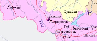
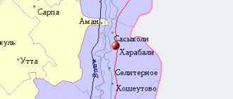
For ease of route planning, we have marked all mentioned cities and attractions on the map of the region:
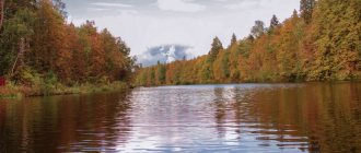
The most famous rivers in the Nizhny Novgorod region
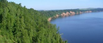
The Nizhny Novgorod region is one of the most water-rich regions in the country. More than 9 thousand different rivers and streams flow through its territory. Of course, the main water arteries of the region are the Mother Volga and its tributary, the beautiful Oka. But here you can find many other rivers worthy of the attention of tourists.
Tesha River
- Coordinates on the map: 399106, 43.317006.
The right tributary of the Oka originates on the Volga upland. The length of the river is 311 km, it flows in a westerly direction, flowing into the Oka near the city of Murom. The water flow is replenished mainly due to snow melting. Tesha is a river flowing in open areas.
Its banks are meadows and fields, where you can occasionally find small birch and oak groves. There are many sandy beaches on the banks of Tesh. Its waters pleasantly cool bathers on a hot summer day. The slow flow and clean surface of the river have contributed to the development of water tourism in these places.
Alatyr River
- GPS coordinates: 816953, 44.611688.
The left tributary of the Sura flows through the territory of three regions of Russia - the Nizhny Novgorod region, Mordovia and Chuvashia. The merger with Sura takes place near a city that bears the same name as the river. The length of the water flow is 307 km, and the basin area is about 11 thousand km2.
The river is mainly fed by snow, but there are also several tributaries. The largest of them are Rudnya and Insar. Alatyr is a floatable river. It freezes in November-December, and by the end of April its waters are almost completely free of ice cover.
Kerzhenets River
- Coordinates: 724899, 44.625384.
Probably the most famous of all the small rivers in the Nizhny Novgorod region. It became famous for the fact that schismatics hid from their pursuers in its vicinity. The Old Believers who lived in dense forests on the banks of this small river (its length is only about 300 km) began to be called Kerzhaks.
Now Kerzhenets attracts tourists not so much with its history as with its pristine nature. Its channel is winding, with numerous pools and quiet backwaters. Due to the shallowness and topography of the surrounding area, the river is not navigable. Its depth is generally up to 1 m, but in whirlpools it can reach 7-8 m.
Kerzhenets swells greatly during floods. Flood rises of water are also common here. Previously, the river was raftable. A lot of driftwood constantly appeared here, creating frequent traffic jams. The rafting has now been stopped and the riverbed is being cleared.
The Kerzhensky Nature Reserve was created in the middle reaches of the river. The real taiga forest is home to many wild animals, including brown bear, lynx and ermine, and there is fish in the river. Between the trees approaching the water, golden stripes of sandy beaches can be seen.
Vetluga River
- Coordinates: 880317, 45.912230.
It is thanks to water streams such as Vetluga that water tourism is developing in the Nizhny Novgorod region. This river is suitable for everyone, even those without special training. The upper reaches of the Vetluga, especially at the confluence with the Matyug River, are chosen by real extreme sports enthusiasts.
In the area of the village of Kruglyzhi, in the Kirov region, there are places where many kayak routes begin. Residents of the Nizhny Novgorod region and guests of the region enjoy rafting down the river, admiring the beautiful nature. Here you can swim, fish, sunbathe on the coastal sandy beaches.
When going on a trip along the river, you should not be afraid of getting wet - in the forests located on the banks of the reservoir, you can easily find firewood for a fire. In the fight against the “little bloodsuckers,” the sandy banks of the river and shallows, well blown by the wind, where you can camp, will help.
Linda River
- Coordinates: 598557, 44.119596.
This tributary of the Volga originates 3.5 km from the village of Trefelikha. Here is the source of the small (only 122 km) Linda River, which flows into the country’s largest water artery.
Although the river is not striking in its size - its average depth is about 1.5 m, and its width rarely exceeds 12 meters, previously timber rafting was carried out along the Linda. The bottom is sandy and muddy in places. The banks of the river are steep and steep. Linda is suitable for kayaking and other outdoor activities.
These places celebrate the opening of the tourist season (in May), as well as its official closing (in September).
Serezha River
- Coordinates: 669219, 43.452265.
The small river (its length is 185 km) is a tributary of the Tesha. Its bed is mostly sandy. It has a fairly fast flow. The high banks of the reservoir are covered with forests, although there are also meadow areas. The middle part of the river is a system of Pustyn lakes of karst origin. In these places, Seryozha forms real water labyrinths.
The river passes through places where there are no large settlements or industries. The ecology in this region is in complete order. Serezha is a calm forest water stream. Pine forests growing on the shores of the reservoir alternate with sandy beaches. There is good fishing here (the river waters are clean), an abundance of berries and mushrooms.
Piana River
- Coordinates: 248991, 45.115406.
One of the longest small rivers in the Nizhny Novgorod region. Its length is 436 km, it practically does not extend beyond the region. Only a small part of its channel is located on the territory of Mordovia.
Piana is very tortuous (the distance from the source to the mouth of the water artery in a straight line is only 65 km). The width varies - from 10 m in the upper reaches of the river to 90 m or more in the lower reaches. The average depth is from 2 to 4 meters, in some places from the surface to the bottom 6-7 m.
The speed of the river flow is small; it increases only at some riffles. The banks rise 5-7 m above the water surface. In some places they are steep and steep. The river is navigable in its lower reaches. It is suitable for water tourism.
Luch River
- Coordinates: 449581, 42.679763.
The Lukh River carries its waters through the territory of three regions at once - Nizhny Novgorod, Vladimir and Ivanovo. Its banks, flowing into the Klyazma, are numerous sandy beaches surrounded by coniferous and deciduous forests.
Kayaking on the Lukh River is an excellent option for family tourism. Good fishing, an abundance of wild berries, mushroom picking - all this only enhances the impression of a walk along the river.
On the river banks is located one of the oldest monasteries - Frolishcheva Monasteries. An excursion to these places allows you not only to have a good rest in nature, but also to touch the shrines of the Orthodox branch of Christianity.
You may be interested in: Where to go in Nizhny Novgorod with a child
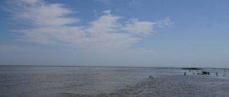
Beautiful Nizhny Novgorod lakes: TOP-8
Another type of water resource in the Nizhny Novgorod region is lakes. Of course, there are not as many such natural objects as rivers, but among them there are examples of interest to tourists and travelers.
Lake Bolshoy Kultey
- Coordinates: 411565, 45.738944.
This reservoir is a natural monument under state protection. Several species of very rare sphagnum mosses grow in its vicinity.
The water pool is located in a funnel-shaped basin and has high, sometimes steep, banks. The lake is surrounded by mixed forest, although the water surface is mostly open. The bottom is covered with a large layer of silt. The average depth is about 3 m. The view of the island is especially beautiful. Bolshoi Kultey from its eastern shore - there is also an excellent place for a tourist stop.
Nearby is the “Kulteysky Spring”, consecrated for the two thousandth anniversary of Christianity. The most convenient sandy access to the waters of the lake is located near the spring.
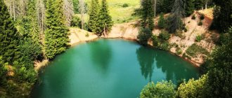
Lake Svetloyar
- Coordinates: 818784, 45.093056.
A huge number of legends and traditions are associated with this reservoir. The waters of Svetloyar are considered holy, giving healing to all who suffer. They say that it was in these places that the Virgin Mary herself left her mark.
Indeed, many events are associated with the lake that cannot be scientifically explained. Legend claims that it was its waters that swallowed up the ancient city of Kitezh, famous for its wealth.
The flow of pilgrims and people who believe in miracles to the lake does not decrease. It is interesting that every year some events take place here that further strengthen faith in the Mother of God, who took these places under her protection.
Lake Bolshoye Plotovo
- Coordinates: 459144, 45.603308.
It is located almost in the center of the Raft Swamp. You can go through the latter when you reach the shoreline of the reservoir. The area got its name due to the fact that local residents here moved not on traditional boats, but on rafts.
The Big Plotskoye Lake itself has quite impressive dimensions - length is 2.2 km, and width is about 1.6 km. Three kilometers from it there is about. Maloe Plotovo. The closest and most convenient approaches to Bolshaya Plotovo are from the south.
Lake Maloye Plotovo
- Coordinates: 422077, 45.568884.
As befits a “younger” brother, this reservoir is smaller in size. It covers an area of about 50 hectares. Researchers believe that in some places the depth of the water basin reaches 18 m. The lake is also surrounded by swamps and there is no free access to it.
The reservoir has had a bad reputation since ancient times. There is a legend about a certain island that appears and disappears in the center of the lake. It draws in people who find themselves on this piece of land. It is believed that this is the abode of swamp evil spirits.
Since 1976, Maloe Plotovo has become a natural monument, and its few guests are fishermen who come here to catch tench and pike.
Lake Bolshoye Polyushkino
- Coordinates: 249827, 45.446237.
This reservoir is also located among swamps. Not far from it there are two more lakes - Malye Yazy and Maloe Polyushkino.
The largest of the water basins is not very impressive in size - only 700 by 400 m. Bolshoye Polyushkino has the shape of an irregular oval, surrounded by marshy banks.
Those who like to fish in this reservoir have their own forum. According to the information provided by the portal, you can find out that the average depth of Bolshoy Polyushkino is 3-4 m. Perch bites especially well here, and black grouse are found in the surrounding forests.
Lake Svetloe
- Coordinates: 535646, 45.477041.
A fairly large body of water, about 1 km in diameter. The water in it is clean, but the bottom is muddy. There are practically no deep-water areas here - only from 1 to 3 m. The shores are surrounded by moss rafts. In these places you can harvest a good crop of cranberries.
The southern side of the lake is most convenient for excursions. There is a place where you can camp, there are approaches to the water and places for swimming.
In the northern part there are several islands formed by rafting. In these small areas of land, mainly pine and birch grow. Near the southern border is the Udel swamp, where one of the tributaries of the Linda, the Visets River, originates.
Black Lake
- Coordinates: 592144, 45.576772.
A large and beautiful reservoir surrounded by swamps. Perhaps because of this, the impression of some kind of gloom is created, which is reflected in the name of this landmark of the Nizhny Novgorod region.
The shape of the lake is a clearly visible figure eight, where the northern part is larger than the southern mirror. The eastern shore has convenient access to the water and parking space. The opposite bank is adjacent to the Kerzhensky Nature Reserve.
On the swampy shores of the Black Lake you can find rafts where cranberries grow. Once upon a time, logging work was carried out in these places. To organize the removal of the tree, a narrow-gauge railway was built from the south.
Lake Ryzhan
- Coordinates: 342231, 45.819685.
An interesting and quite large body of water. The shape of the lake is unusual - it is an irregular rhombus, reminiscent of the tip of a spear. The water basin stretches from north to south, and there are many good approaches to it.
The lake at its widest part reaches almost 900 m, and the distance from the southern point to the northern is about 2.8 km.
The beauty of the local landscapes is added by the pine and birch forests surrounding the lake. The southern shores of the water basin are high - there is a road going around the reservoir. In the northern part the coast is a little swampy.
The northeastern coast of the reservoir has convenient tourist parking and access to the water. On the west coast, in the central part, there is the only sandy beach suitable for swimming.
Boldino
The sights of the Nizhny Novgorod region are concentrated not only in its capital. One of the main ones is the Boldino Museum, which is inextricably linked with the name and work of the greatest Russian poet Alexander Sergeevich Pushkin. These places belonged to his family for several centuries, so they can be considered the patrimony of the Pushkin family. Now it is a literary and memorial monument that attracts a large number of tourists every year. Even after the revolution, the authorities decided to preserve the poet’s family estate, and in 1949 it became a state museum-reserve. Now on its territory there are as many as 13 architectural objects and two incredibly beautiful parks. The decoration of the estate is made in the style of the early 19th century, the times when the poet lived here, so you can calmly immerse yourself in the history of that era.
Nizhny Novgorod region: famous springs and springs
The Nizhny Novgorod region has various water bodies on its territory. One of these are underground springs and springs. Many springs have water that is considered holy and healing. There are many places in the region associated with the spread of Orthodoxy in Rus'. And almost every place significant for believers has a holy spring, which has its own healing power and history.
Maryevsky spring
- Coordinates on the map: 461008, 43.638936.
Since ancient times, this source was called Shumleysky. Most likely, the spring got its name because of the noise it makes. Now the name “Marevsky” is used - after the village of Maryevka, located nearby.
Tradition says that Seraphim of Sarov once visited here and predicted miraculous healings with the waters of the spring. Nowadays, both local residents and numerous travelers coming from afar come for healing water from the spring.
The spring is rich in silver ions, its water has antibacterial properties. There is a chapel, a bathhouse, and a place where you can collect water from the holy spring. It is especially crowded here on the feast of the Epiphany.
Spring of Our Lady of Vladimir
- Address: Bortsovo village, Dalnekonstantinovsky district.
Getting to the source is easy. The bus route heading towards Arzamas will take travelers to the village of Bortsovo, where the holy spring of Our Lady of Vladimir is located.
Finding the underground key itself is quite easy. A dirt road passing through the settlement will lead to the spring. Coming out to the ravine, which is located to the left of the path, you should go around it. At the cross the descent to the bottom of the depression begins. There is a holy spring flowing there.
There is also a chapel near the spring, and it also has its own bathhouse. The path leading down is quite steep. You need to go down it carefully to avoid unnecessary injuries.
Spring Kibelek
- Address: Vladimirskoye village, Voskresensky district.
The spring gushing out of the ground near Lake Svetloyar is considered holy. The bridges laid from it will lead to a path that ends at the grave of three saints. According to legend, a battle between the squad of the city of Kitezh and the Tatar army took place here. Here, in an unequal duel, three Russian heroes died defending their native land.
In memory of the brave warriors, three crosses were erected, next to which there is a well. The water in it is also considered holy and healing, as evidenced by reviews online. Nearby, in a clearing in the forest, are the graves of heroes. Believers take holy soil from the burial site. It is also believed to help heal illnesses.
Spring Prince Vladimirsky
- Address: Sartakovo village, Bogorodsky district.
Bogorodsky district, Sartakovo village - this is where the holy spring is located. The spring itself is located in a chapel built above it. There are men's and women's baths here. The territory of the attraction is well-groomed and is a miniature ethnographic museum.
Next to the holy spring there is the Berezopole Museum. It is located in a beautiful wooden mansion. On the hill, above the source, stands the Church of Prince Vladimir, where services are held. The water of the Vladimir Holy Spring contains a lot of lime. It is not advisable to boil it.
Nikola key
- Address: Beloglazovo village, Gorodetsky district.
Legends popular in these places tell that a miracle once happened here - the appearance of St. Nicholas the Wonderworker. The waters of the springs, flowing together, form a kind of cross. It is believed that this speaks of the special holiness of these places and springs.
On the territory of the chapel where the spring is located, there are two indoor baths. The spring waters contain silver ions and are considered healing.
Nikola Klyuch is located near the village of Beloglazovo. From the parking lot located next to the settlement, it is about 200 meters to the source. There is no car access to the spring. It can only be reached on foot.
Baranov key
- Address: Kozlovka village, Kstovsky district.
This source has been known since ancient times - the route to the Makaryevskaya Fair passed next to it. However, its holy waters became known in Rus' only at the beginning of the 19th century.
It is in the chronicles of that time that one merchant named Baranov suddenly became blind. In a dream, the Mother of God appeared to him and ordered him, after praying, to wash himself with water from a local spring. Having done everything as the Mother of God said, the merchant received his sight.
Since that time, there have always been many pilgrims at the source. At his own expense, the merchant built a chapel here. The place was named after the merchant who had regained his sight. Now there is a stone chapel and a washroom.
Holy springs of the 12 apostles
- Address: Vad village, Vad district.
They come out of the ground in the village of Vad, located in a small and shallow ravine. Nearby there is a well-equipped and well-maintained bathhouse. Tradition says that these underground springs were discovered by Saint Seraphim of Sarov. This happened when he was going to the Zelenogorsk convent.
It's not difficult to get here. From Nizhny Novgorod you should get to the village of Vad. Then a local bus will take travelers to the “Holy Springs” stop. All that remains is to reach the red brick gate and go down into the ravine to the springs.
House of Countess Panina
In a small town, which has the funny name Gorodets, there is another one of the most significant attractions of the Nizhny Novgorod region, namely: the house of the noble Panin family, who for centuries played a very significant role in the state. It is built entirely of wood in the Empire style. It is very rare to encounter such architecture. Now it houses a museum called the house of Countess Panina, where you can fully enjoy the original culture of the city, which was characteristic of it in the 18th - early 20th centuries, when landowners used it as their own residence. There are several interesting original paintings by Russian and foreign masters, as well as various antiques and items of ancient Russian crafts.
Forest resources of the Nizhny Novgorod region
Thanks to the availability of water resources, more than half of the Nizhny Novgorod region is occupied by various forests. There are mighty pine forests, oak forests, and numerous groves here. Most forest areas are located in the northern part of the region, where forest cover reaches 80% of the total area.
Ichalkovsky pine forest
- Coordinates: 435892, 44.542074.
This forest area is part of the state reserve of the same name. There are several hypotheses about the origin of relict boron. First, this forest was formed in the pre-glacial period. The second hypothesis says that boron arose somewhat later - during the Valdai glaciation.
Northern and mountain tree species have been preserved in this area due to its geological structure. There are many active sinkholes of karst origin, with high humidity and a high content of calcareous rocks enriched with dolomite. All this is the result of the centuries-old “work” of the Piana River
Ichalkovsky Forest is a unique place where centuries-old trees coexist with representatives of the “underworld” - caves, sinkholes, and numerous underground passages. There are more than 1000 different geological “surprises” here. And some of the failures are quite impressive in size.
Koposovskaya oak grove
- Coordinates: 376620, 43.844658.
The forest area is located in the Volga floodplain. It is interesting because it consists almost entirely of oak trees reaching a height of 25 m. The age of the trees is also approximately the same - they are from 250 to 300 years old. Dubrava is a natural monument, located near a village bearing the same name.
A unique corner of nature – the kingdom of birds. There are nightingales, chaffinches, and field thrushes here; Birds that need protection from extinction also live in these places.
Koposovskaya oak grove is also a famous historical place, as the past tells us. Before the October Revolution, rallies and May Day meetings were held in the forest, and during the Patriotic War, tanks produced at Krasnoye Sormovo and waiting to be sent to the front were hidden here.
Sergach Arboretum "Yavleika"
- Coordinates: 541374, 45.471114.
Another natural monument of the Nizhny Novgorod region. The uniqueness of the local landscapes is that representatives of flora from all over Russia grow here. The complex is located on picturesque hills. In the depths of the ravines interspersed with hills, a small stream, Yavleika, runs. He gave the name to the arboretum.
The history of the array began in 1979, when it was decided to test the survival of a wide variety of tree species in local conditions. For the fortieth anniversary of the Victory, a park was built here. A year later, the arboretum was combined with the park, creating a unique natural site. Now, on 90 hectares of the arboretum, more than 200 species of plants from all over the world grow.
Reserved grove Luchinnik
- Coordinates: 978886, 45.321210.
The forest area is located near the village of Bolshoye Boldino. There is a legend about the origin of the name of the local grove.
Once upon a time, a peasant who was caught stealing his owner’s wood said that he did this because he did not have enough money to buy a torch to illuminate his hut. A.S. Pushkin, the owner of the estate, who was present at the same time, canceled the due punishment, saying: “Wait to chop, the forest will grow - everyone will be a good archer.” Since then this place has been called that.
The picturesque grove is surrounded by numerous glades and meadows. From the edge, a path running down leads to a spring. Old-timers say that the source was here back in the time of the great poet.
In the grove, where mainly oaks, maples and ash trees grow, there is a clearing surrounded by birch trees. It is here, on Pushkin’s birthday (June 6), that a poetry festival is held.
The beauty of the underground kingdom of the region
Probably, in any area where there are hills, there are also many dungeons. Their origin may be different. Here are former mines or underground workings, and karst caves or dungeons that appeared in soft sedimentary rocks. There are similar facilities in the Nizhny Novgorod region.
Balakhonikha Cave
- Coordinates on the map: 438539, 43.341028.
The dungeon is located in the Arzamas region. This is a gypsum cave with hemispherical vaults. In its central part, underground corridors diverge in different directions. They are connected to each other by several galleries.
The interior decoration of the attraction is quite picturesque. Here you can admire the bluish-gray columns. These are all kinds of frozen stalactites and their antipodes - stalagmites.
Stone tract
- Coordinates: 450320, 44.469484.
This natural site is located near the village of Ichalki, near the village of Balakhna. The stone tract is a quarry with many entrances (50 of them). These are small grottoes and caves, almost half filled.
Of the dungeons, the Balakhninskaya Cave is of greatest interest to tourists. It belongs to karst formations. The entire Stone tract is replete with cramped corridors and passages, access to which is very difficult. However, this does not bother the bats. Several species of these animals live here.
Peshelan mines
- Coordinates: 319446, 43.947437.
In these places there is a museum of mining, geology and speleology. In the former mines there is a statue of the owner of the gypsum mountain, there is a collection of minerals, and there is an exhibition of dinosaurs.
Guests will be able to visit a speleologists' camp set up near an underground stream with a waterfall. There is also a room of fear here. And the shungite room, a landmark of the Peshelan mines, has a positive effect on the body of tourists who visit the cave.
Bornukovskaya Cave
- Coordinates: 389849, 44.780784.
It is considered the deepest cave in the Nizhny Novgorod region. It has two vertical entrances, so to get into the dungeon, tourists should have special equipment. The rocks that formed the cave cavity are clay and gypsum. As a result, even in the summer heat there are low temperatures here.
The underground lake and waterfall located here remain frozen all year round. Bornukovskaya Cave is well suited for extreme tourism. It is made of rocks of a reddish hue, which is why it looks bright and attractive.
Seraphim-Diveevo Monastery
Let's return again to the religious places of Russia, to the Seraphim-Diveevsky Monastery and to its main attraction - the Holy Trinity Cathedral. This place is simply covered in legends, especially about the history of its creation. According to legend, it is believed that the Venerable Elder Seraphim learned about the place where the temple should be founded from the Mother of God herself, after which he bought the area with his own money.
The monastery itself is located in the village of Diveevo; its construction began in 1865. The design was carried out by architect Rezanov. That is why the building has much in common with the Moscow Cathedral of Christ the Savior. First of all, it gained its fame because of its interior decoration. Only here the painting was done not on the walls, but on huge canvases, which cannot be found anywhere else in Russia. The icon of the Mother of God “Surprise”, decorated with precious stones and enclosed in a gold frame, is kept here.
One of the main monastery shrines is the Holy Kanavka. According to legend, in the fall of 1825, the Mother of God appeared to St. Seraphim and commanded him to found the Mill community, simultaneously indicating how to enclose this place with a rampart and a ditch. Only the sisters of the community were allowed to dig them, but laymen could also fill the shaft and carry the earth. According to Seraphim, this Groove is so high that it will always be a protection and wall from the Antichrist. In 2011 it was restored. A religious procession of many thousands took place along the Holy Kanavka with an ark containing the Belt of the Most Holy Theotokos.