Volgograd is located very well. The regional center unites a region that covers the southeast of the European Russian Federation. The area runs in the direction from north to south and from west to east. The total length of the borders of the region under consideration is 221.9 km. There is contact with the borders of the following regions:
- Saratov region is the northern border (approximately 30% contiguous).
- Voronezh region - northwestern section (common border more than 11%);
- Rostov region - western and southwestern perimeter (combines 27% of the common border);
- Astrakhan region - southern and south-eastern direction (more than 11% of the total border);
- Republic of Kalmykia – southern part (combines 11% of the border);
- Kazakhstan – eastern section (10% of the border connected).
Volgograd serves as the administrative center of the region. The total area of the hero city is 859 square kilometers.
Flag of Volgograd: heraldry today and history
The region has an advantageous location in terms of geography. On the one hand, the region allows access to the southern part of the Russian Federation. As a result, access to the border zone of neighboring states, namely Iran, the Caucasus, Ukraine and Kazakhstan, is opened. On the other side is the center of the Russian Federation and the Volga region. The perimeter in question crosses an important body of water. The Volga-Don Canal is based on two key reservoirs - the Volga and Don, respectively. This arrangement opens up new perspectives. There is access to several water resources, namely the Caspian, White, Baltic, Black and Azov seas.
The total perimeter of the region is approximately 113,000 square kilometers. About 78% of this area is in the agricultural sector.
Climatic conditions
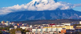
Volgograd and the region are located in the continental climate zone. An arid atmosphere prevails in the region. The northwestern section is occupied by forest-steppe, and the east belongs to the semi-desert region, which in some places borders on the category of complete desert. For almost the entire month of January, average temperatures are 8-12 degrees below zero. In July, the air temperature rises to 23-25 degrees above zero.
In the northwestern part, about 500 mm of precipitation falls, and in the southeast this figure is less than 300 mm. The maximum air temperature can reach +44 degrees. Most often, an abnormal increase in the indicator occurs in July-August. Minimum temperatures can reach -42 degrees. Such cold weather occurs in January-February.
Winter precipitation in the region occurs within 90-110 days. During this time, up to 22 cm of snow may fall. For many years, researchers have been monitoring the stability of snow cover.
As a result, it was possible to find out that in the North and South, winter precipitation lasts for different periods of time. For the northern part, this indicator falls on December 11-17, and in the south – on December 20-25.
On the territory of Volgograd and the region, the winter period most often begins in December. It lasts 70-90 days. Spring is quite short. It starts in March-April. Sometimes there are frosts in May. This phenomenon causes significant damage to agricultural vegetation and local gardens.
The actual onset of summer generally occurs in May, but there are times when the final warmth begins in June. Summer lasts approximately 3.5 months. Autumn is quite big. It begins in the second part of September and lasts until the first half of December. Situations are often observed when frosts begin to form in October.
Story
On May 13, 2000, in accordance with the order of the President of the Russian Federation No. 849, the North Caucasus Federal District was formed.
The North Caucasus Federal District includes: the Republic of Adygea (Adygea), the Republic of Dagestan, the Republic of Ingushetia, the Kabardino-Balkarian Republic, the Republic of Kalmykia, the Karachay-Cherkess Republic, the Republic of North Ossetia-Alania, the Chechen Republic, the Krasnodar Territory, the Stavropol Territory, the Astrakhan region, Volgograd region, Rostov region. The center of the federal district is the city of Rostov-on-Don.
On June 21, 2000, in accordance with the order of the President of the Russian Federation No. 1149, the North Caucasus Federal District was renamed the Southern Federal District.
On January 19, 2010, in accordance with the order of the President of the Russian Federation No. 82, changes were made to the “List of Federal Districts” and the North Caucasus Federal District was separated from the Southern Federal District.
The Southern Federal District includes: the Republic of Adygea (Adygea), the Republic of Kalmykia, Krasnodar Territory, Astrakhan Region, Volgograd Region, Rostov Region.
On July 28, 2016, the President of the Russian Federation signed a decree (No. 375) “On the Southern Federal District,” according to which the Southern Federal District and the Crimean Federal District are being transformed into the Southern Federal District “in order to increase the efficiency of government bodies.”
The Ministry of Foreign Affairs of Ukraine protested in connection with the inclusion of Crimea in the Southern Federal District, sending a note of protest to the Russian side, and also appealed to the UN Security Council with a request to condemn the inclusion of the peninsula in the Southern Federal District. However, the Russian delegation to the UN Security Council blocked Ukraine's draft press statement, which condemns the inclusion of Crimea in the Southern Federal District.
The Commissioner of the President of Ukraine for the rights of the Crimean Tatar people, Mustafa Dzhemilev, called on Western countries to impose sanctions for the entire Southern Federal District.
Centers of federal districts
As already mentioned, all federal districts have city centers, within which certain authorities are located that control the activities of the entire district. They do not always coincide with the largest populated area of the administrative-territorial unit. All information can be seen in the table.
| Name of the federal district | Center |
| Central Federal District | Federal city – Moscow |
| Northwestern Federal District | Federal city – St. Petersburg |
| Volga Federal District | Nizhny Novgorod |
| Southern Federal District | Rostov-on-Don |
| North Caucasian Federal District | Pyatigorsk |
| Ural Federal District | Ekaterinburg |
| Siberian Federal District | Novosibirsk |
| Far Eastern Federal District | Vladivostok |
A change in center is possible only if a certain entity moves from the department of one territorial-administrative unit of a new type to another. Of the above settlements, Pyatigorsk and Nizhny Novgorod are not the largest in their federal districts.
First day
It’s convenient to start exploring the historical center of Volgograd at Station Square, where the railway station is located. In front of it you will see the Barmaley fountain , made in 2013 in the image of a pre-war fountain. The composition with a round dance of children against the backdrop of destruction caused by air strikes appeared in a photograph from 1942 and made an indelible impression of the contrast of smiling children and the ruins of the city.
From the square, walk to several architectural monuments of pre-revolutionary times. On the street Gogol there is a red-brick mansion of the Repnikovs , which houses the Volgograd Memorial and Historical Museum with an exhibition about the Civil War. If you walk along Kommunisticheskaya Street, you will see the Tsaritsyn fire brigade building , restored according to the original of the 19th century.
Fire tower Photo: © Igor Butyrskii
Next, go to the Square of Fallen Fighters, past the monument to Alexander Nevsky and the New Experimental Theater in a building from the early 20th century. The Alexander Nevsky Cathedral , which was located on the Square of Fallen Fighters until it was blown up in the 1930s, is being rebuilt in the Alexander Garden It is worth walking along Volgodonskaya Street with several merchant houses of the late 19th century.
On the Square of Fallen Fighters you will see an obelisk to the defenders of Red Tsaritsyn near the grave of the Red Guards. Many people were also buried in the mass grave during the Great Patriotic War, and the Eternal Flame was lit in their memory. Not far from the grave of the Three Heroes there is a poplar tree that survived military battles. The green area with memorials is surrounded by post-war buildings. Don't be put off by Stalin's neoclassicism, in the style of which many buildings in the restored Stalingrad were built. The monumentality was intended to reflect the heroic and difficult times of the war. The central department store on the square was restored after the war and houses the Memory Museum . The exhibitions tell about the headquarters of the German commander F. Paulus located in the basement and his capture.
Details: Square of Fallen Fighters
In the Memory Museum Photo: © grau59
Along the Alley of Heroes you go to the central embankment named after the 62nd Army . First you will see the Art Fountain from 1957. Nearby there are two propylaea - structures with 8 columns, from which the central staircase . It connects the upper and lower tiers of the embankment. Steam shipping on the Volga actively developed at the beginning of the 19th century; many merchant ships stopped at the Tsaritsyn port, but the improvement of the area near the water began only at the beginning of the 20th century. Then a landslide practically destroyed the embankment, and the area along the river was redecorated again in the 1930s. After the war, restoration work began, which was completed by 1952. The staircase was built on the site of a military crossing; now during the holidays it is used as an amphitheater. There are various monuments on the embankment; pay attention to the Church of John the Baptist (2001), built on the site of the first stone church of Tsaritsyn.
In detail: embankment of the 62nd Army
Central staircase Photo: © Vasilina Babkovskaya
On the embankment there is the “Rodimtsev Wall” - a memorable place where Major General Rodimtsev’s division landed, which came to help in the battles for Stalingrad. Above it is the “Battle of Stalingrad” panorama museum with a large-scale painting about the defeat of the enemy at Stalingrad. In addition to the panorama, the museum’s halls display items related to the Battle of Stalingrad - personal belongings of the battle participants, photographs, weapons. Next to the futuristic museum building, the Gerhardt mill . This building was significantly damaged during the fighting, and its appearance continues to remind us of the destructive power of war. In front of the mill there is a second fountain, “Barmaley”, which against its background looks almost like a photo from the war years. It’s also worth going to Pavlov’s house , where our soldiers held the defense. The house was rebuilt after the battles, and a memorial wall was installed on it.
Details: Panorama Museum “Battle of Stalingrad”
Gerhardt's Mill Photo: © Maksim Starostin
What to see in Volgograd in 3 days? One of the “Seven Wonders of Russia” is Mamayev Kurgan . This is the main city attraction, consisting of a complex of objects “Heroes of the Battle of Stalingrad”. During the war, the height of the mound was called “Height 102.” Capturing and holding this height was of strategic importance for each side; it offered good visibility and shooting opportunities, so numerous heavy battles took place here. However, the feat of the defenders of Stalingrad made a turning point in the war. His memory is immortalized in a large-scale historical and memorial complex. The main object is the sculpture “The Motherland is Calling!” 85 m high. Together with it, the ensemble consists of several squares and sculptures, bas-reliefs, ruin walls, a memorial cemetery, and the Hall of Military Glory with the Eternal Flame.
More details: Mamayev Kurgan
Complex on Mamayev Kurgan Photo: © Vasilina Babkovskaya
You can get to Mamayev Kurgan by metrotram - this is a high-speed Volgograd tram, most of the stations of which are underground. Tourists recommend trips on the metrotram as one of the city's attractions. From Mamayev Kurgan you can go down to the Volgograd Arena stadium , built for the 2022 World Cup. For relaxation, you can stop in the central park of culture and recreation with attractions and a Ferris wheel.
Detailed advice on what to see in Volgograd in 1 day
Volgograd Arena Stadium Photo: © Sergey Makhinin
Notes:
- List of federal districts (approved by Decree of the President of the Russian Federation of May 13, 2000 N 849) // Rossiyskaya Gazeta, 05/14/2000.
- Decree of the President of the Russian Federation dated June 21, 2000 N 1149 “Issues of ensuring the activities of the offices of plenipotentiary representatives of the President of the Russian Federation in federal districts.”
- Decree of the President of the Russian Federation dated January 19, 2010 “On introducing amendments to the list of federal districts approved by Decree of the President of the Russian Federation dated May 13, 2000 N 849, and to Decree of the President of the Russian Federation dated May 12, 2008 N 724 “Issues of the system and structure of federal executive authorities"" // Official Internet portal of legal information of the Russian Federation, 01/19/2010.
- The Crimean Federal District was formed on March 21, 2014 after the annexation of Crimea to Russia. It included the Republic of Crimea and the federal city of Sevastopol: Decree of the President of the Russian Federation “On the formation of the Crimean Federal District” No. 168 // Official website of the President of the Russian Federation, 03.21.2014; The Territories of the Russian Federation 2015. L., NY, 2015. P. 308-320.
- The Decree on the Southern Federal District was signed // Official website of the President of the Russian Federation, 07.28.2016; I. Preobrazhensky. Comment: Why did Putin leak Crimea? // DW, 01.08.2016.
- Kyiv was outraged by the inclusion of Crimea in the Southern Federal District // Lenta.ru, 07.28.2016.
- Ukraine: Russia blocked the statement on Crimea in the UN Security Council // DW, 07.29.2016; Russia blocked the Ukrainian project for the sake of UN Security for the sake of Crime // UKR Mission to UN, twitter.com.
- Dzhemilev on the need for sanctions for the entire Southern Federal District // YouTube, 07.28.2016; Official page of the Plenipotentiary Representative of the President of Ukraine for the rights of the Crimean Tatar people Mustafa Dzhemilev on Facebook, 08/01/2016.
- Territory area of the Russian Federation by constituent entities of the Russian Federation as of January 1, 2015 // Federal State Statistics Service. Moscow, 2015. P. 5.
- Population estimate as of January 1, 2016 // Federal State Statistics Service, 01/01/2016.
- Republic of Crimea // Official website of the Federation Council of the Russian Federation; 26,081 sq. km – according to the Information and Referral Service of Ukraine: Territory of Ukraine // Information and research site “Ukraine”.
- Sevastopol // Official website of the Federation Council of the Russian Federation; 864 sq. km – according to the Information and Referral Service of Ukraine: Territory of Ukraine // Information and research site “Ukraine”.
- Population estimate as of January 1, 2016 // Federal State Statistics Service, 01/01/2016.
- Population estimate as of January 1, 2016 // Federal State Statistics Service, 01/01/2016.
- Astrakhan region. Estimation of the resident population as of January 1, 2015 // Federal State Statistics Service, 01/01/2015.
- Volgograd region. Estimation of the resident population as of January 1, 2016 // Federal State Statistics Service, 01/01/2016.
- Krasnodar region. Estimation of the resident population as of January 1, 2016 // Federal State Statistics Service, 01/01/2016.
- Rostov region. Estimation of the resident population as of January 1, 2016 // Federal State Statistics Service, 01/01/2016.
- Population of the Russian Federation by municipalities as of January 1, 2016 // Federal State Statistics Service, 01/01/2016.
- Kalmykia. Estimation of the resident population as of January 1, 2016 // Federal State Statistics Service, 01/01/2016.
- Number of permanent population in municipalities of the Republic of Crimea as of 01/01/2016 // Federal State Statistics Service, 01/01/2016.
- Population estimate as of January 1, 2016 // Federal State Statistics Service, 01/01/2016.
- Ustinov Viktor Vladimirovich. Biography // Southern Federal District. Plenipotentiary Representative of the President of the Russian Federation in the Southern Federal District.
City infrastructure
Volgograd is a city with a developed transport system. Due to its large extent, the government has to pay great attention to this area. The main transport today is the underground tram, trolleybuses, buses, minibuses and taxis.
Today, 2 main roads have been built, stretching almost the entire city. These are the First and Second longitudinal ones. They are located parallel to the Volga, and other streets connect them with each other. They can be called the central arteries of the city, along which the main flow of personal and public transport moves.
2nd longitudinal
The underground tram in Volgograd is like a metro. This structure is the only one in Russia. The tram connects Traktorny and Voroshilovsky districts. Most of its route the tram runs along the ground line, but in the Central region it runs underground.
Volgograd metrotram
There are electric trains that also connect areas of the city. From the central station in two directions - in the south and north they go according to schedule. This is one of the most convenient ways to travel, for example from the Center to the Krasnoarmeysky district. But the most popular transport in the city today is minibuses. They move in all directions and connect all corners of the city.
The length of Volgograd is about 90 km. And therefore there is no route that would connect the extreme points of the city. Those. from the Krasnoarmeysky district to Spartanovka you will have to travel with a transfer. But still the transport system is developed quite well. And from Volgograd it is very easy to get to both nearby areas and remote cities (by train, plane or bus).
Highway congestion in Volgograd increases every year. Today, traffic jams occur every day in the Central region. During construction, such a number of cars was not taken into account, so difficulties arise with movement. Traffic jams in the Tulak area are also frequent, but they are more related to two crossings, along which trains travel quite often, which means they are closed. There are now traffic jams in the Sovetsky district, sometimes the Second Longitudinal in Krasnooktyabrsky is stuck. Surprisingly, there are never traffic jams in Krasnoslobodsk and Volzhsky. Perhaps this is what causes the resettlement of residents.
Volgograd is a modern city, which means it is equipped with everything for the development of children and youth. The city has 240 municipal kindergartens, plus many private development centers, 102 secondary schools, about 30 lyceums and gymnasiums, 31 sports schools and about 30 art schools. Today there is a tendency to create private educational institutions, so it is difficult to give an exact figure. But in addition, there are a large number of places for leisure, clubs and sections for children and adults.
Volgograd has 5 large universities, 4 academies and many institutes and branches of institutes. Every year, up to 40 thousand people graduate from the above-mentioned institutions. They train specialists in various fields: from doctors and teachers to engineers working with laser technology.
Volgograd Agricultural Academy
Legal status
There is no information about federal districts in the Constitution of the Russian Federation. A number of experts believe that this type of territory is still a territorial-administrative unit, only of a new type. Analogies are drawn with the division of the past - the General Governments (GI) and the districts of regional activities (the French Fourth Republic).
The Plenipotentiary Representative of the President of the Russian Federation, who operates in central cities, is not the head of local authorities. His main activity is monitoring the work of federal government structures. Among the latter are:
- Troops of the Russian Guard.
- Central Bank Office.
- Customs departments of the FSB.
- Rosrezerv.
- Roskomnadzor.
- Prosecutor General.
- Rosprirodnazdor.
- Centers
In each federal district there are city centers in which the authorities supervising the work are located. Their activities are controlled by the plenipotentiary representative of the President of the Russian Federation and his subordinate structures, municipal bodies and structures. In a number of federal districts, centers are not the largest populated areas. This is observed in Privolzhsky (Nizhny Novgorod compared to Kazan) and North Caucasus (Pyatigorsk is smaller than many cities). A similar situation was observed before the abolition of the Crimean Federal District (Simferopol is smaller than Sevastopol).
Crime
This is what our reader Medved writes about crime in the city (for which we sincerely thank you!): as in every more or less large city in the Russian Federation, there are places where it is better not to walk without a weapon during the day. And in the dark they’ll even unscrew the head - let’s start in order:
Traktorozavodskoy district - the lower village of VGTZ, partly the village of Spartanovka - is a little more than completely full of cattle, drugs and other scum. It is strongly NOT recommended to move even one step away from the main street, and to the question “Boy... Will there be a cigarette??” respond with a blow of brass knuckles between the eyes. Without words. In war it’s like in war.
Krasnooktyabrsky district - the village of Metallurgov (not to be confused with the avenue) and the so-called Petite France - the former area of dormitories - the rest of the Monolith complex and the lower barricades - mainly alcohol, although there are other interesting personalities. More or less efficient and genetically non-alcoholic youth live in Moscow/St. Petersburg and other capitals.
The central region is the actual focus of the “hero”. generally calm, although... The central embankment is a real chance to get a feather in the side, especially from the “southern” brothers, whose inadequacy correlates with the long nose. And the village of Angarsky is basically a complete dope place. In slang - zombie.
Voroshilovsky district - Dar Gora, the entire private sector is full of gypsies and grass. It’s just a plank lover’s paradise, now the valiant police have somewhat reduced the assortment, but the author remembers the times when checks flew out of the windows of apartments on the first floors of houses opposite the dorm.
Kirovsky district - special attention to the village. Beketovka, reeds and huge dogs in them. homeless people. And if you run into a pack, the only way to survive is to run. They attack immediately in a pack and without warning. Of course, locals deliver with Chinese switchblades, but those who fight decently, as a rule, don’t interfere - they’re just rocking the boat.
Krasnoarmeysky district is a difficult place. The people are generally good, but there are places like Lower Sarepta and the village of Khimikov. Either the produced sarin had such an effect on the offspring, or acquired injuries - but colorful personalities often emerge.
There is also organized crime, but it is called business and rarely interferes with the affairs of mere mortals. He especially dislikes former military personnel/veterans of hot spots - the author guarantees.
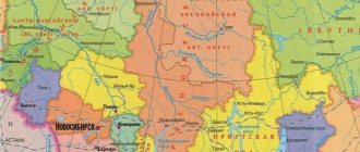
Map of federal districts
For convenient familiarization with the territory occupied by the federal districts, appropriate geographical maps have been developed. You can find them in special atlases or on online resources. Among the latter, a good option is the site https://geostudy.ru/fo.html.
The convenience of maps lies in the fact that in addition to boundaries and occupied area, you can see the location of cities and other settlements, as well as geographical features - the location of reservoirs, forests, mountains, agricultural land, and so on.
What is this
There is no definition of the concept in the Constitution, that is, they are not part of the administrative-territorial division of the state. The creation took place according to the principle of the formation of military districts and economic regions, but does not coincide with them either in number or composition. We can say that the federal district is a large territory, which includes several subjects of the state.
Enterprises and work in Volgograd
Volgograd is a large city with developed industry. The largest contribution to development is made by heavy industries, namely: metallurgy, mechanical engineering, metalworking, chemical enterprises, and energy.
Electric and heat power enterprises: Volzhskaya HPP (the largest in the European part of Russia), Volgogradskaya CHPP-3 and CHPP-2, Volgogradskaya GRES.
Metallurgical enterprises: producing special-purpose steel; OJSC Volgograd Aluminum; LLC Volgograd Non-Ferrous Metals Plant. Metalworking and mechanical engineering: OJSC "Volgogradneftemash" - products for oil production; OJSC "Volgograd Drilling Equipment Plant"; OJSC "Volgograd Plant of Tractor Parts and Normals"; JSC "Volgograd Transport Engineering Plant"; OJSC "Volgograd Shipyard" and others.
Chemical plants and enterprises: OJSC "Kaustik" is one of the largest chemical companies. ; OJSC "Plastcard"; JSC Volgograd Oxygen Plant.
These enterprises account for 46% of total industrial production. They provide jobs for most of the population. But as a result of their work, significant environmental pollution occurs.
A large number of people are involved in the food and service industries. The city always requires specialists with technical education, since the above-mentioned enterprises require qualified personnel. Also in Volgograd there are many companies involved in the sale of manufactured products; therefore, people are required who are ready to work in the trade sector.
BC Volgograd City
The chains of large stores “Magnit”, “Pyaterochka”, “Lenta” invite employees to work almost constantly. The average salary in the city is 15-20 thousand rubles in the spring of 2012.