Nature
Relief
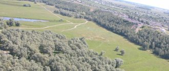
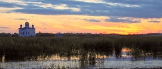
Exhibition forest-steppe in the Shilka River basin. Photo by D.V. Solovyova
40% of the territory is occupied by high mid-mountain ridges. 1200–1900 m - Yablonovy, Chersky, Olekminsky Stanovik, Borshchovochny, Daursky, etc. In the north stretch the Kodar ridges (up to 3072 m high - the highest point of the Ch. O.), Kalarsky, Udokan. In the south there is the Khentei Highlands (up to 2580 m high, Mount Sokhondo), in the west there is part of the Vitim Plateau. In the southeast there are low mountains (Gazimursky, Nerchinsky ridges, etc.) and the accumulative-denudation Uldza-Borzinsky plain. The ridges are separated by depressions (Khilokskaya, Kalarskaya, Charskaya, Ingodinskaya, etc.).
Geological structure and minerals
About geological for the structure of the territory, see Art. Transbaikalia. Nedra Ch. o. extremely rich in mineral. resources. The region occupies a leading position in the country in reserves of molybdenum (1/3 of the reserves of the Russian Federation), zirconium (32%), copper (over 24%), titanium (approx. 20%), uranium (approx. 16%). Large and unique deposits are localized in the territory: copper ores (Udokan deposit), molybdenum (complex Bugdainskoye, with Pb, Ag and Au), zirconium (complex Katuginskoye, with Ta, Nb, REE and U), titanium (complex Chineyskoye, with large reserves of iron ore; Kruchininskoye apatite-ilmenite-titanium-magnetite), uranium (Streltsovskoye ore field), gemstone raw materials (Sherlovogorskoye - beryl, topaz and tourmaline; Malkhanskoye - colored tourmaline). The territory has a powerful raw material base of gold (about 9% of the reserves of the Russian Federation), there are several. dozens of primary deposits (including the Balei-Taseevskoe gold and silver deposit, which is super-large in terms of initial reserves), and a large number of placer deposits. Ch. about. also stands out in the Russian Federation means. fluorite reserves (large deposits - Garsonuiskoye and Urtuiskoye).
Climate
The climate is sharply continental. Winters are long and severe with stable clear weather, summers are warm and hot in the south. Wed. January temperatures range from -37.5 °C in the north to -19.7 °C in the south (absolute minimum -66 °C), July 13.6 °C and 21 °C, respectively (absolute maximum 42 °C). Precipitation ranges from 250–300 mm per year in the south to 900 mm or more in the north; Max. the amount falls in July–August. Snow cover thickness is 10–20 cm or less in the south, 80–100 cm in the north in the mountains. The glaciation area on the Kodar ridge is 19 km2. The Kodar, Udokan, Kalarsky, Chikokonsky, Chatanginsky ridges are areas of increased avalanche danger. Permafrost is developed everywhere, with island permafrost in the south.
Inland waters
In Ch. o. there is a watershed between the basins of the Pacific [Shilka, Onon, Ingoda, Argun (Amur River basin)] and Northern Arctic [Khilok, Chikoy (tributaries of the Selenga River, Lake Baikal basin) rivers); Olekma, Vitim (tributaries of the Lena River)] oceans. In winter, rivers freeze to the bottom and ice forms. In summer, during the rainy season, catastrophic events occur. floods. The rivers are fed by rain and snow. Of the 15,000 lakes, the largest are Bolshoye Leprindo, Leprindokan, Nichatka, Arakhley, Kenon, Shakshinskoye, as well as Zun-Torey and Barun-Torey (mineralized). Large reservoirs – Kharanorskoye, Priargunskoye.
Soils, flora and fauna
More than 50% of the territory is occupied by mid-taiga forests of Gmelin larch (Daurian) with an undergrowth of dwarf cedar, dwarf birch, rhododendron on podburs; in the southeast there are larch herbaceous forests with an admixture of pine and birch on sod-taiga deep-freezing soils; in the south (on the Khentei Highlands) there are dark coniferous forests of cedar and spruce. In the north there is larch taiga at altitudes. 1300–1500 m is replaced by a narrow belt of cedar-elfin thickets with an admixture of Middendorf birch and alder, passing higher into rocky, lichen tundra on lithozems and char. To the southeast Exposure forest-steppe areas are widely developed: in the north. on the slopes there are forests of larch, pine, and birch with an undergrowth of rhododendron; on the southern slopes there are steppes. In the Shilka basin there are representatives of the monsoon forests of the Far East (Mongolian oak, elm, hazel). Bottoms of intermountain basins center. and sowing areas are swampy (ryams). In the south there are grass steppes, tansy steppes with thickets of elm and apricot, freezing on powdery-carbonate chernozems. In the feather grass-wormwood steppes there are light chestnut soils. Around the lakes Zun-Torey and Barun-Torey there are abundant salt marshes, the soils are deep-frozen solonchaks. In general, the flora includes more than 1,700 species of higher vascular plants (rare ones include radiola rosea, milky-flowering peony, Bush lily, etc.). Berry bushes (blueberries, lingonberries) are abundant.
There are more than 500 species of vertebrates, 330 species of birds, 5 species of amphibians. In the taiga, bear, deer, musk deer, elk, mountain hare, sable, wolf, squirrel, chipmunk are common; in the highlands - bighorn sheep, reindeer; in forest-steppes and steppes - ground squirrel, jerboa, pika, hamster, tarbagan. Among the birds that live in the mountain tundra are the white partridge and the alpine accentor; in the taiga - capercaillie, hazel grouse, black grouse; in the steppes - Mongolian and gray larks, pipit, bunting, etc. Blood-sucking insects and ticks are abundant. Numerous birds nest on lakes Zun-Torey and Barun-Torey. waterfowl and semi-aquatic birds. There are 40 species of fish in the rivers, lenok, whitefish, grayling, taimen, and carp are common; Endemics have almost disappeared - kaluga, Amur sturgeon, Davatchan. In the Red Book of Ch. o. 57 species of birds, 25 species of mammals, 7 species of fish were included.
Condition and protection of the environment
Tense environmental The situation is typical for industrially developed areas of the southeast. parts of the Black Sea region, in areas where mineral resources are developed (especially uranium, polymetallic ores, etc.). The most polluted air is in the cities of Chita, Petrovsk-Zabaikalsky, Krasnokamensk. The category of “dirty” includes rivers. Nercha, sections of the Argun, Shilka, Ingoda rivers.
Protected natural areas occupy 5.4% of the area, among them - the Daursky Reserve, the Sokhondinsky Reserve, the national. Alkhanay, Chikoy parks, 1 natural park, federal nature reserves (Burkalsky, Tsasucheysky Bor, Dzeren Valley, etc.), 18 regional reserves, 65 natural monuments (Kodara glaciers; extinct volcanoes Aku, Syni, Chepe; Charsky Sands tract; Arest lakes , Shibety; Kheetei cave, etc.). Lakes Barun-Torey and Zun-Torey belong to wetlands protected under the Ramsar Convention.
Historical sketch
The oldest traces of human activity in the region (about 300 thousand years ago) are represented by deflated stone products (Sukhotino-16 on the Ingoda River, Masterova Gora on the Khilok River, Taranovka on the Chikoy River). The early period of the Upper Paleolithic includes the Tolbaga and Kunaleyskaya cultures, the later - Studenovskaya and Sukhotinskaya (all in Western Transbaikalia), including dwellings in the form of tents and huts with facings of stones; works of art, etc. Approx. 11 thousand years ago the Mesolithic begins, at its end there are ground burials with crouched corpses (Menzin culture in the southwest of the region). The Neolithic (from about the 5th millennium BC) is represented by taiga and steppe settlements, round-bottomed ceramics with stamped ornaments, and writings.
Archeological monuments from the territory of the former Chita region: 1 – image of a bear’s head made from the bone of a woolly rhinoceros. Tolbaga parking lot (Petrovsko-Zabaikalsky district); 2 – writing Larg... ZabSU (1, 3); photo by S.V. Alkina (2); Transbaikal Regional Museum of Local Lore (4, 5)
In the Early Metal Age (from the end of the 1st third of the 2nd millennium BC), sources of copper and tin were used in the basins of the Argun, Shilka, and Onon rivers. Remains of smelting furnaces are known. The culture of tiled graves, deer stones, and from the 2nd floor spread in the steppe. 1st thousand in the river basin Chikoy – kereksurs; in the forest-steppe - the palace culture of semi-sedentary cattle breeders and hunters; in the taiga - the Khentei culture of hunters.
Con. 1st millennium BC e. – beginning 1st millennium AD e. represented by the Zorgol culture (correlated with the northern Xianbi group), dep. monuments of the Xiongnu culture. In the East The Burkhotuy culture (presumably one of the groups of the Shivei people) has been identified in Transbaikalia; in the forest-steppe and steppe of the east and southeast of Ch. – Darasun culture (ca. 6–9 centuries). A number of monuments from the 10th–14th centuries. associated with early Mongolian culture. OK. the turn of the 1st and 2nd thousand in the river basin. Shilka appears a system of fortified settlements with Far Eastern traditions of fortification, cultivation of millet, buckwheat, etc., which is associated with the advancement of Mohe groups from Sr. Amur region. In the 11th–12th centuries. on the left bank of the Argun, approx. 10 fortified settlements. systems to the north border of the Khitan state - the Liao Empire (“The Wall of Genghis Khan”).
From the 13th century the region was part of the Mongol Empire, mainly was part of the ulus of Tuluy, the youngest son of Genghis Khan. Hirhiru is associated with Yesunke (Esungu, Isunke); Kondui Palace, burials on Mount Okoshki, etc. - from Mongol. aristocracy; Undugun culture 12–15 centuries. – presumably with groups of the local Tungus-speaking population. With sunset Mong. powers in con. 14th century and the weakening of the steppe Mongols, the Mongol-speaking group from the shores of Lake Baikal advances to the East. Transbaikalia along the Khilok and Chikoy rivers, displacing the Tungus and influencing their culture. By the 17th century A striped band of foot, reindeer, and horse Tungus (Evenks) and Mongol-speaking groups is formed.
Since the 1640s Transbaikalia entered the sphere of interests of Rus. state The first Russian explorers who appeared in the region in the 2nd half. 1640s – 1st half. 1650s, became I. I. Pokhabov and E. P. Khabarov. In 1653, a detachment of Cossacks led by P.I. Beketov founded Nelyutsky (from 1659 Nerchinsky) and Irgensky forts. From ser. 1650s the region was used as a political place. exile and hard labor (the first exile was Archpriest Avvakum Petrov; in the 19th – early 20th centuries, the Decembrists, participants in the Polish uprising of 1863–64 and the Garibaldians who joined them, N.G. Chernyshevsky, populists, Bolsheviks, Socialist Revolutionaries, etc.). As a result of the signing of the Treaty of Nerchinsk in 1689, Transbaikalia became the extreme southeast for more than 150 years. territory of Russia. During this period, the settlement of Mongol-speaking groups on the Ingoda, Aga and Onon rivers continued. In 1708–64 the region was part of the Siberian province, in 1764–1851 – of the Irkutsk province. From the beginning 18th century the mining industry developed, the first fatherland was obtained. silver and then gold. Borders of Russia empires in the region were specified by the Burin Treaty of 1727 and the Kyakhta Treaty of 1727. In the 18th–19th centuries. The most important trade routes between Russia and China passed through Transbaikalia, ch. Kyakhta became the center of trade (founded in 1728, from 1743 Kyakhtinskaya Sloboda). All R. – 2nd floor 18th century The Nerchinsk mountain region was formed. The region was part of the Transbaikal region (1851–1922) and the Transbaikal province (1922–1926), and in 1926–30 it comprised the Chita and Sretensky districts of the Far Eastern Territory. In 1929, during the Soviet-Chinese conflict on the Chinese Eastern Railway, units of the Special Red Banner Far Eastern Army moved from the territory of Transbaikalia under command. V. K. Blucher.
In 1930–36 Transbaikalia was part of the East Siberian Territory. By decree of the All-Russian Central Executive Committee of March 5, 1934, the Ch. o. was formed for the first time in its composition. with its center in Chita. Pl. 272.1 thousand km2. Us. St. 700 thousand people Included 22 districts, 4 cities, 8 workers' settlements. By resolution of the Presidium of the All-Russian Central Executive Committee of December 7, 1934 Ch. was abolished due to the disaggregation of the East Siberian Territory. In 1935, the Transbaikal Military District was formed with its center in Chita. In 1936–37 Transbaikalia was part of the East Siberian region.
Secondary Ch. o. formed by a resolution of the Central Executive Committee of the USSR dated September 26, 1937. Included 21 districts and Vitimo-Olyokminsky national. env. East Siberian region; Zeya region (4 districts); Aginsky and Ulan-Onon aimags of Buryat-Mong. Autonomous Soviet Socialist Republic that made up the Aginsky Buryat-Mong. (since 1958 Buryat) national. (from 1977–1980 autonomous) district. Pl. 640.8 thousand km2 (1947), 431.5 thousand km2 (1986). Us. St. 1.3 million people (1986), St. 1 million people (2005). By the Decree of the Organizing Committee of the Armed Forces of the RSFSR dated September 21, 1938, the Vitimo-Olyokminsky national was liquidated. env. Baley (1938), Borzya, Mogocha (both 1950), Khilok and Shilka (both 1951), Krasnokamensk (1969) received the status of cities. By resolution of the Presidium of the USSR Supreme Council dated August 2, 1948, 6 districts of the Ch. were transferred to the Amur region.
Ch. about. was an important center of the mining industry (including the mining of coal, gold, fluorspar, tantalum, tungsten, molybdenum, rare metals, uranium, etc.), logging, in the 2nd half. 20th century Mechanical engineering developed from the end. 1960s - light industry. Railway traffic is open. lines: Kharanor - Dosatui (1940, narrow gauge), Borzya - Solovyovsk (1941), Dosatui - Tsurukhaytai (since 1962 Priargunsk) (1957, narrow gauge), lines Kharanor - Urulyungui - Krasnokamensk (1972) and Urulyungui - Priargunsk (1973) broad gauge ; sections Nizhneangarsk - Novaya Chara and Novaya Chara - Tynda (both 1987) of the Baikal-Amur Mainline.
According to the Law of the Russian Federation of April 21, 1992 “On Amendments and Additions to the Constitution (Basic Law) of the RSFSR”, the status is independent. a subject of the Russian Federation (while remaining territorially part of the Ch. o.) received the Aginsky Buryat Autonomous Okrug. Since 2000 Ch. as part of the Siberian Federal District.
Based on the results of the referendum held on March 11, 2007 in Ch. and Aginsk Buryats. Autonomous Okrug, Ch. o. became part of the Trans-Baikal Territory, formed on March 1, 2008 by the Federal Law of the Russian Federation dated July 21, 2007.
Economy
The region has developed non-ferrous and ferrous metallurgy, mechanical engineering (car assembly plant, mining equipment plant), electric power (Chita and Kharanorskaya state district power plants), coal, light (worsted and cloth mill).
The region is a large agricultural region east of Lake Baikal, specialized in fine-fleece sheep farming. Meat and dairy and meat livestock farming, partly pig farming, and poultry farming are also developed. Crop production takes place, the main sown areas are concentrated in the central, southern and south-eastern regions. Hunting is developed in the mountain taiga and northern regions.
Transbaikalia is significantly removed from the western part of the country, at the same time it is close to the Russian Far East and occupies a key position on the way to the Pacific Ocean and the countries of Southeast Asia. The distance by rail from Chita to Moscow is 6074 km, Ekaterinburg - 4386, Novosibirsk - 2861, Khabarovsk - 3327, Irkutsk - 1013 km.
The region is rich in natural resources, such as non-ferrous and precious metals, iron ore, coal, fluorspar, and various construction raw materials. The most famous deposits: polymetallic ores - Novoshirokinskoye; copper ores - Udokan; titanium-magnetite ores - Kruchininskoe; coal - Kharanorskoe.