Ivdel is the northernmost city of the Sverdlovsk region. The name is given after the river of the same name, on the banks of which it stands.
When we visited this city, Ivdel pleasantly surprised me. Previously, I imagined it as gray, nondescript, with numerous colonies for prisoners, as it would seem befitting the Sverdlovsk capital of the camps. However, Ivdel turned out to be a pleasant, cozy and quite beautiful town.
I propose to get acquainted with the history and sights of Ivdel.
History of Ivdel
In 1589, at the confluence of the Ivdel and Lozva rivers, the first Russian settlement beyond the Ural Mountains was founded - Lozvinsky Gorodok on the Vishero-Lozvinsky route from Cherdyn to Siberia. However, a few years later, after the opening of the Babinovskaya road and the founding of the city of Verkhoturye, Lozvinsky Gorodok ceased to exist.
In 1773, breeder and landowner V.A. Vsevolozhsky (1737–1797) bought vast forest lands from the Stroganovs - the lands of Zaozerskaya Dacha. Later, the land passed to his nephew Vsevolod Andreevich Vsevolozhsky (1769–1836), who launched an active search for gold. In 1825, the Vsevolodo-Blagodatsky gold mines arose. Numerous mines appeared on the Ivdel River and its tributaries.
At the mouth of the Shapsha River, a left tributary of the Ivdel River, 5 km upstream from the modern city in 1831, next to the gold washing factory of the Preobrazhensky and Znamensky mines, the Ivdel village was founded. This year is considered the official birthday of the city of Ivdel.
After the death of Vsevolod Andreevich Vsevolozhsky in 1836, the lands of the Zaozerskaya Dacha were divided among his heirs. The northern part of the Dacha in 1849 went to his youngest son Nikita (1799–1862). The Ivdel village was moved downstream of the river to its modern location. The settlement was renamed the village of Nikito-Ivdelskoye. The site of the former settlement is now known as the Old Ivdel tract.
In 1849-98, the North-Zaozersk gold mine administration of N.V. was located in Nikito-Ivdelsky. Vsevolozhsky and his heirs, and later – the mine management of Northern Zaozerie.
At the beginning of the 20th century, about 1,200 people lived here, there were 2 churches, 6 trading shops, a zemstvo school, and a library.
N. Sorokin in his work “Journey to the Voguls” (1873) wrote about the village of Nikito-Ivdelskoye, which he visited in 1872:
“On the steep rocky banks of the river. In Ivdel, houses of very good architecture are located in regular lines; there are even those that have mezzanines. The church, although wooden, is of quite beautiful architecture, rises majestically, surrounded by a new lattice. A small ferry constantly passes through the river, which, as is the custom of Siberian rivers, seethes and rushes between stones. In general, the location of the village is much more beautiful than Vsevolodobladatsk. The mountains that complete the picture are covered with dense forest.”
After the revolution, in 1924, the village was renamed Ivdel. At the same time, active logging began in its vicinity. In 1937, the notorious Ivdellag was founded. In 1943, Ivdel received city status.
In the late 1930s - early 1940s, the Serov-Polunochnoe railway was built, and in the 1960s - to the Priobye station.
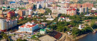
The population of Ivdel is 16 thousand people. For comparison, in 1967 the population reached 28 thousand people. The city is the center of the Ivdel urban district - the largest municipal formation in the Sverdlovsk region by area.
Economy
Among the mineral resources, bauxite, iron, copper, manganese ores, gold have been explored, and there are coal reserves. Railway station "Ivdel-1" on the line "Ekaterinburg - Priobye". The Serov-Khanty-Mansiysk highway passes through the city. Main enterprises:
- Woodworking plant
- Enterprises operating main gas pipelines
- Forestry Operations Directorate
- Forestry
- Hydrolysis plant (went bankrupt in the mid-2000s)
Sights of Ivdel
The city of Ivdel, although very small, has something to see here.
At the entrance to the city, to the left of the road, guests are greeted by the Ivdel cedar grove . This is an old cultivated cedar forest. It is considered the northernmost pine pine forest near the village in the Sverdlovsk region (except for single cedar trees in Burmantovo). There are up to 300 cedars here, ranging in age from 130 to 170–200 years. Some trees have several girths. You can see pine cones on the branches. It is interesting that in ancient times the Mansi burials were located in this grove.
A city park has been created in the cedar grove; if you wish, you can swing on the colorful swings. Most of the grove's territory is occupied by trees of other species and a stadium. Since 1983, the Ivdel cedar grove has the status of a botanical and archaeological natural monument of the Sverdlovsk region.
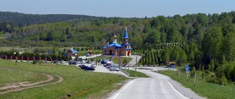
Then the road crosses the picturesque Ivdel River via a bridge, beyond which you find yourself in the city center. embankment was built on the left bank of the Ivdel River . An amazing place for such a small town. Walking along the Ivdel embankment is a pleasure. You can sit on a bench overlooking the river and relax after a long journey.
Behind the embankment you can see the recently built wooden Annunciation Church . It began with a prayer house, opened here in 1994.
But let's return to the bridge over the river. Behind it, Mekhanoshina Street leads to a monument to the victims of the Great Patriotic War with an eternal flame and the names of the victims.
Behind the memorial is the town square . Like in any other Russian city, there is a monument to V.I. Lenin. From the north, the square is limited by the Ivdel administration building, and from the east there is the building of the Severny Mayak cinema . This is the main cultural center of the city. By the way, before the revolution, the Nikitsky Church stood on this site.
On the opposite side of the square there is a beautiful wooden building of the Ivdel Historical and Ethnographic Museum (Danilova St., 78, tel. +7 (34386) 2-23-49). The museum was founded in 1928 by teacher I.E. Uvarov (1884–1958), who collected historical artifacts and documents about the history of the city. A year later, the first museum exhibition consisting of Uvarov’s finds was opened at the club. In the 1940s, it was decided to create a full-fledged museum. In 1973, one of the oldest buildings in the city, built in the 19th century, was given to the museum. The exhibition consists of seven sections with separate halls. The fauna and flora, pre-revolutionary history, the history of Ivdel from 1917 to 1945, industry, education and healthcare, as well as minerals are presented here. A separate hall is dedicated to the indigenous people - the Mansi.
Not far from the museum, on Danilova Street, you can see and take pictures at the art object “I Love Ivdel” .
In the vicinity of the city, a little upstream on the Ivdel River, there are beautiful rocks . A path leads to them along the left bank of the river. The rocks reach a height of up to 70 m and stretch for about 2 km. They have numerous pillar-like projections, in some places even reminiscent of the famous Usva Pillars. The slopes and peaks are covered with coniferous forest. The Ivdel River itself is suitable for tourist rafting. True, the once pure northern river was poisoned by the UMMC company, owned by the oligarch Kozitsyn.
When visiting Ivdel and its surroundings in late June - early July, you can admire the white nights. If you continue your journey north, you can see the unique architecture of the village of Polunochny, as well as an unusual dam in the rocks and “stone casemates” from the times of Ivdellag
Mountain of the Dead
Despite the remoteness from civilization, these places are in great demand among lovers of hiking and skiing. The reason for this is the Dyatlov Pass. It is located on a mountain that the Mansi call “Kholatchakhl”. Translated into Russian it means “Mountain of the Dead.” She became famous after the mysterious death of a group of tourists. Before this incident, the mountain was nameless and was designated on the map as height “1079”.
In February 1959, a group of ten experienced tourists went on a hike of the third degree of difficulty. The leader of the group was Igor Dyatlov. It was not possible to climb to the top before dark, and the tourists set up a tent on a gentle slope. After dinner we began to settle down for the night. And then something terrible happened!
According to investigators, there was panic. The tourists cut the tent with knives and, naked, without shoes, rushed to run down the slope. The tracks indicated that people were trying to scatter to the sides, but it was as if some force was driving them together. The tracks disappeared in the forest, and soon the search team discovered several corpses of tourists under the snow.
Monument to those who died for Soviet power on the river bank
After some time, the remaining corpses were found near the stream. Their skin had an unusual dark brown color. Many had terrible internal injuries - broken ribs, broken skulls, severely damaged internal organs. And at the same time, the skin is almost not affected! In the vicinity of the camp, no traces of the presence of strangers or a natural disaster were found. The investigation has reached a dead end.
More than 50 years have passed, but the strange death of the children remains a mystery. There are many versions of what happened. According to one of them, the tent was covered by an avalanche. However, searchers found her on the surface of the snow. The streamers were not torn down, the sticks stuck in the snow were not knocked down. The incident was also explained by the phenomenon of a “perfect storm” - a natural phenomenon that generates ultrasound, causing panic. It was assumed that tourists were poisoned with methyl alcohol, attacked by wild animals, and exposed to ball lightning.
There were also purely “man-made” versions. The Dyatlovites were allegedly killed by escaped prisoners. Or they suffered at the hands of the Mansi, as tourists encroached on the sacred mountain. They assumed a quarrel between the tourists themselves. Or for some reason the group was attacked by IvdelLAG guards. However, the investigation found all this unfounded.
The tourist route to the Dyatlov Pass passes through Ivdel
Among the more plausible hypotheses, conspiracy theories should be noted. Tourists could get into the area of secret military tests. This is evidenced by the testimony of eyewitnesses who saw luminous objects over the mountain that day. There may have been a rocket or vacuum bomb explosion. In this case, tourists suffered from the blast wave or were removed as unwitting witnesses. The clue for the “military” version could be a strange railway line near the village of Polunochnoye, which runs into the mountain. In addition, a local hunter allegedly found rocket debris two years after the tragedy.
Perhaps a rocket filled with phosgene depressurized over Mount Kholatchakhl. In this case, suffocation occurs only a few hours after poisoning. All this time the person does not notice anything except a sweetish taste in the mouth. When the tourists began to choke, they cut the tent in panic and ran away. Of course, they thought that the source of the suffocation was in the tent. The survivors were killed as witnesses. Then the military put pressure on the investigation to cover up the incident. How else can you explain that the case was classified?
The mysterious incident has aroused great interest for many years. Two fiction books, a dozen and a half documentaries, several television shows and the feature horror film “The Mystery of the Dyatlov Pass” are dedicated to the tragedy. Now these places are regularly visited by tourist groups. Some come in search of a solution to the mystery, others to test themselves, and others to honor the memory of the dead. In 1963, a memorial plaque was installed on the stone outcrop. And in 2012, three plates were mounted depicting the pages of the Ural Pathfinder magazine with an article about the Dyatlov group.
How to get to Ivdel?
To get here, you need to drive from Yekaterinburg to the Serovsky tract. Before Serov, turn towards Ivdel. There are also buses from Yekaterinburg and passenger trains going to the Ob region to the city of Ivdel. Distance from Yekaterinburg – 520 km.
Sources: Wikipedia Kirsanov V.A., Petrov M.F. Protection and rational use of cedar forests // Scientific basis for the placement of natural reserves in the Sverdlovsk region. – Sverdlovsk, 1980. Rundkvist N.A., Zadorina O.V. Sverdlovsk region. Illustrated encyclopedia of local history Chupin N.K. Geographical and statistical dictionary of the Perm province. - Perm, 1873.
Pavel Raspopov
Adventures from our tourist club in this direction
12.03 – 19.03 |
8 days Ski trip to Dyatlov Pass
Ski trip – To the Manpupuner plateau – Ural
Hiking – Through the Dyatlov Pass to the Manpupuner Plateau
Hiking – To the Dyatlov Pass
Climate
The climate is sharply continental. Winter is relatively harsh and long, beginning in mid-October and ending in the first ten days of April. Frosts can reach -40 °C or less. Summer is short and cool, but when well-warmed air is carried out from Kazakhstan, temperature increases to +30 °C and above are possible.
| Climate of Ivdel | |||||||||||||
| Index | Jan. | Feb. | March | Apr. | May | June | July | Aug. | Sep. | Oct. | Nov. | Dec. | Year |
| Absolute maximum | 5,0 | 6,5 | 16,9 | 26,6 | 34,3 | 35,1 | 37,4 | 33,3 | 30,3 | 23,4 | 9,9 | 6,2 | 35,1 |
| Average maximum, °C | −14,1 | −10,5 | −1,7 | 6,9 | 13,9 | 20,8 | 22,8 | 19,7 | 12,7 | 3,3 | −4,9 | −11,3 | 4,9 |
| Average temperature, °C | −18,7 | −16,3 | −8 | 1,4 | 7,7 | 14,5 | 17,0 | 13,9 | 7,7 | −0,3 | −9,2 | −16 | −0,5 |
| Average minimum, °C | −24,2 | −22,5 | −14,5 | −4,1 | 1,3 | 7,5 | 10,9 | 8,5 | 3,3 | −3,9 | −13,3 | −21,4 | −5,9 |
| Absolute minimum, °C | −49 | −46,6 | −44,7 | −30,4 | −14,4 | −4,4 | −0,4 | −3,1 | −8,5 | −29,4 | −44,9 | −48,6 | −49 |
| Precipitation rate | 21,7 | 15,8 | 17,7 | 27,3 | 40,6 | 56,1 | 87,1 | 71 | 53,1 | 38,8 | 26,4 | 24,2 | 479,8 |
| Source: [thermo.karelia.ru/weather/w_precips_ru_ivd.shtml “Thermo Karelia.Ru”] [www.worldclimate.com/cgi-bin/grid.pl?gr=N60E060 “World Climate”] | |||||||||||||