The name of the city was given by the Luga River, and its name comes from the word laugas, which translates from Estonian as swamp. A Slavic settlement existed here already in the 10th century. During the reign of Catherine the Second, by her order, a city was built on Luga.
The poet Nadson, who visited Luga at the very beginning of the 19th century, gave a detailed description of the city. Alexander Sergeevich Pushkin stopped here several times on his way to his Pskov estate. He did not describe this town very flatteringly:
There is a city in Russia called Luga, in the St. Petersburg district. This little town wouldn’t be any worse if it weren’t for my Novorzhev in the world.
During the Great Patriotic War there were heavy battles here. The city was severely destroyed, but many houses miraculously survived.
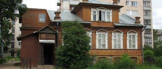
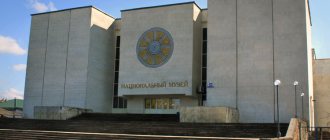
Luga Museum of Local Lore
The museum, created in 1976, is located in a former merchant estate. The building miraculously survived the war and occupation. In the museum's exposition you can see collections of coins, a collection of old photographs, a huge amount of materials about the war of 1941-1945, and the stands display documents about the guests of the city: Rimsky-Korsakov, Ershov, Chaliapin.
Address: Red Artillery Street - 11A.
What to see in Luga in one day
Over the centuries of its existence, Luga has seen a lot: the luxury of noble life, the harsh morals of revolutionary times and bloody wars. All this left a special imprint on it and made it attractive in the eyes of travelers who love the secrets of the past and the spirit of antiquity. Among the countless attractions of Luga, objects that are in particular demand among tourists stand out. Such attention is completely deserved, because these places give the most complete picture of the values and culture of the city.
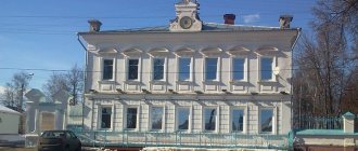
Museum of History and Local Lore
- Address: st. Red Artillery, 11A.
The Luga Museum of History and Local Lore was founded in August 1977. Its location was a former merchant estate, which is an architectural monument of the 19th century.
The central hall is dedicated to an exhibition dedicated to military topics. Much attention is paid here to the Luga border, partisan movements, underground resistance and the liberation of the city from fascist occupiers. The exhibition presents rare photographs and original documents testifying to the heroism and courage of Ludzhan residents during the war years.
The second largest and most important exhibition is called “Palaeontology in the Luga Region”. Its exhibits are the fossilized remains of creatures that lived during the Devonian period. These artifacts were discovered during paleontological excavations in the vicinity of the Luga River.
A small hall is dedicated to an exhibition demonstrating the natural wealth of Luga. In glass cases you can see recreated forest landscapes. The compositions are supplemented with plant samples, models of mushrooms and stuffed animals and birds.
The museum often organizes themed events, focusing on the work of local painters and folk craftsmen.
Small Luga Canyon
- Coordinates on the map: 58.824908, 29.986736.
Near the village of Ploskoye, on the Oredzh River, there is an unusually picturesque lake surrounded by a pine forest. A small canyon stretches along the coast, which appeared as a result of the washing out of limestone rock. The height of the canyon reaches three hundred meters - from this point a stream falls into the lake, too small for the proud name “waterfall”.
This corner of nature is famous for the purity of the virgin forest and fresh air, saturated with the resinous smell of pine. It is best to come here in the summer, because... In winter, ice and snowdrifts make it very difficult to get to the canyon.
Langina Mountain
- GPS coordinates: 58.715354, 29.842262.
Langina Mountain is famous for the fact that the second line of the Luga border passed through it. Today, a memorial complex dedicated to the heroes of the Great Patriotic War has been opened on this site. It includes:
- Memorial plate in honor of the awarding of Luga with the Order of the Patriotic War, first degree;
- 122 mm howitzer M-30;
- A machine-gun reinforced combat vehicle, which fired at the eastern approaches to the line;
- A bunker that shelled the Pskov highway and the bridge over the Obla River.
- Anti-tank barrier with the signature “Luga Line 1941”.
- "Worship Cross of Christ", erected in 2008.
Langina Gora is the main memorial and historical complex of the city. Every year, rallies are organized here in honor of Great Victory Day.
Church of the Holy Great Martyr Catherine
The temple, built in honor of St. Catherine, is one of the first to be erected in the city of Luga. The temple was built with money allocated by Catherine II. In appearance, the very modest church is more reminiscent of the architecture of a Protestant church. At the beginning of the twentieth century, the city administration decided to expand the church with the help of extensions; the project had already been approved, but was not implemented due to the revolution. In the 30s of the last century, the church was closed and until 1993 the temple stood looted and closed. In the second half of 1993, the church was consecrated and given to the diocese.
Address: Kirova Avenue-54.
How to get there
You can get there in three ways:
- By car - 150 kilometers, approximate cost of gasoline is 600 rubles.
- By train - they go from the Baltic Station, check the schedule on the Russian Railways website. Cost 430-470 rubles per trip.
- Buses run from the Obvodny Kanal metro station, schedule on the city website. Cost 220-260 rubles.
Church of St. Nicholas
The church was built in 1904 according to the design of G. Dietrich in the neo-Gothic style with the money of parishioners. At the end of 1937 the church was closed. In 1941, it was reopened by the German occupiers and services were held there; after the liberation of the city (1943) from the Germans, the church was closed again and finally. After the war, a gym was built there, and in 1996 the church was consecrated and it resumed its parish.
Address: Uritsky street-44.
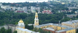
Resurrection Cathedral
The temple was built with donations in 1873 by architects V.V. Windelband and G.I. Karpov. In 1891 On the northern side of the cathedral, construction began on a chapel in honor of the painful death of Alexander II.
In 1937, the temple was closed by decree of the Soviet government, and the clergy were shot. Already in 1938, it housed a cinema, and according to other sources there was a dance floor. During the Second World War, the Germans used the building as a military unit. Since 1991, the cathedral has been considered operational and the restoration of shrines is still underway.
Address: Kirova street-54.
History of the city
The city of Luga stands on the river of the same name, after which it is named. There are different versions of the origin of the name “Luga”. One of them is that during the time of the Celts, local peoples named the river in honor of the god Lugh, whose name translated means “sparkling.” The second version refers to Estonian - Lagua, "swamp" or "pit", or Finnish - Lauuka, "salmon gate".
In 1777, by decree of Catherine the Great, the settlement was given city status. In the same year, construction of stone houses and churches began. In 1781, the city became a district town, and St. Petersburg residents flocked here to improve their health, since there are many mineral springs in Luga.
The Second World War did not bypass him either. Many buildings were destroyed as the city's residents put up desperate resistance to the enemy. This is evidenced by numerous monuments to heroes and victims.
Photo: Pokrovskaya street (Kirova Ave.) and the cathedral in 1912
Cathedral of Our Lady of Kazan
The initiators of the construction of the cathedral were residents of the western part of Luga. The construction of the temple took place from 1901 to 1904. according to the design of N. G. Kudryavtsev in the neo-Byzantine style . One of the most valuable shrines of the temple is a cross with life-giving particles of wood from Golgotha, as well as the main icon of the Kazan Mother of God and the face of the Pechersk Mother of God, found in the 16th century. In 1904, the cathedral was illuminated in honor of the Kazan Mother of God.
In 1936, the cathedral was closed for 2 years. During these two years, a driving school was opened here, the building was completely redesigned. And after the driving school, the building was occupied by the city library. During the Great Patriotic War, 41 military rifle regiments were stationed here. But, despite military operations and occupation, the temple was consecrated in 1942 and returned to believers in 1947. Repair work continued until 1977. During this period, the portraits and iconostasis were restored and painted. Currently, the cathedral is operational and open to its visitors.
Address: Gagarin street-27.
LiveInternetLiveInternet
“Luga Switzerland” is the name given to the Luga district of the Leningrad region with its picturesque landscapes, clean air, forests, meadows and lakes. Therefore, these places have long attracted wealthy people who built their estates here.
The origin of the land of Luga
In the era of Ancient Rus', these lands provided the Slavic tribes with access to the Baltic Sea. During the Middle Ages, Poluga region was often attacked by Germans, Lithuanians and Swedes. In the vicinity of Luga in time immemorial, the squads of Princess Olga and Alexander Nevsky passed through and built the Russian fleet. The Luga River was first mentioned in the Laurentian Chronicle in 947 in connection with the campaign of Princess Olga to Novgorod: “I went Vodga to Novgorod and established Mete dues and tributes and for Luza pogosts and tributes.” The purpose of this campaign was to subjugate the local population to the power of the princes.
The churchyards established by Olga were originally points for collecting tribute and settling court cases. Princess Olga can almost be considered a native of these places. The village of Vybutsky Pogost, 13 km south of Pskov, is considered its homeland. The chronicle says that Prince Igor took a wife from Pleskov (as Pskov was called in ancient times).
The 13th century is a heroic era in the history of the region. In 1240, the German crusaders invaded here. They managed to capture Pskov and Izborsk, as well as lands along the Luga River, right up to the Sabelsky churchyard, i.e., come almost close to Novgorod. Most likely, they finally destroyed Gorodets as an ancient fortress covering the closest approaches to Novgorod from the west. The advance of the German knights to the East was stopped by Alexander Nevsky, who finally defeated the invaders on the ice of Lake Peipus in the battle of 1242.
In 1346, in the same way as the crusading knights, Lithuanian detachments led by Prince Olgerd invaded the Luga land, who “Took Shelona to Gomen and Luga to the Saber.”
For a long time it was believed that on the site of the current city of Luga there was a Novgorod suburb founded in 1384, simultaneously with the city of Yam (now the city of Kingisepp). Indeed, the chronicle mentions “the city of Kamen on Luga, on Yama,” but Luga is undoubtedly mentioned here only as a river. The territory of the modern Luga region was connected with the Baltic coast and Novgorod by a fiber river route: Shelon - Mshaga - Luga. Along the right bank of the Luga River there was a section of the Klinskaya road (isn’t the name of the village of Zaklinye connected with it), connecting Russa and Pskov with the Ivangorod road near the village of Yam-Tesovo.
R. Meadows
The time that followed the annexation of Novgorod to Moscow (in 1478) can be called relatively prosperous. In the first half of the 16th century, a network of settlements developed. The maximum population occurred in the middle of the 16th century. The main Iva and city roads with pit stations are being developed, and bridges and gates are being systematically repaired. It passed through the territory of the Luga District from the village of Kamennye Polyany to the border with the Gatchina District near the village of Cholovo. The road was paved in the same way as pavements in cities. On each fathom, up to 10 logs were driven close to each other.
In 1557, the Livonian War begins. The region suffers from raids by Polish-Lithuanian and Swedish troops. Many churchyards were destroyed, their churches burned. The same fate befell the Syabersky, Gorodetsky, and Cheremenetsky monasteries. The year 1582 was especially difficult, when more than half of the villages were depopulated.
The church in the village of Kamennye Polyany in the name of John the Baptist is associated with the years of the first victorious years of the Livonian War. It was built in the 1560s and is a unique monument of ancient Russian architecture for the Poluga region, where a connection can be traced with the architecture of the Belozersky churches.
In the scribe books of the Shelonskaya Pyatina, compiled in 1581-1582, among the villages of the Dremyatsky churchyard, the “village of Lusskoye” was first mentioned, and nearby Vitovo, Zapolye, Retyun, Leskovo and others, which are now located not far from the city of Luga.
In the short period of Godunov's reign, the Luga land begins to recover. The Ivangorod road came to life again. In 1602, the Danish Duke Hans, the groom of Princess Ksenia Borisovna Godunova, drove along it, and soon died in Moscow.
The famine of 1601 - 1603, then the Time of Troubles again caused the decline of the region. B1610 - 1612 almost the entire Novgorod land was practically occupied by the army of the Swedish general Jacob Delagardie; a joint Russian-Swedish administration ruled here for 6 years. Swedish garrisons stood in small fortresses (the Russians called them gorodki, forts, and the Swedes called them shants).
In 1617, a peace treaty was concluded between Russia and Sweden, named Stolbovsky after the place of its signing in the village of Stolbovo (on the Syasi River).
Russia was forced to cede its lands in the Baltic states to the Swedes, including the Izhora land with the cities of Koporye, Yam, and Ivangorod. The dividing line ran along the lower reaches of the Oredezh River and further along the Luga River, so that a wide strip of the Luga region from Lake Samro to the Rydenki River turned out to be a border zone. The population remaining under the Swedish crown began to leave the territory of Ingermanland, as the Swedes called the Russian land that had passed to them. Because of this, armed clashes broke out between the opposing sides, which from 1655 took on the character of a real war. The history of the Luga region can include the heroic actions of the militia and peasant partisan detachments to liberate the village of Perechits, the battles for Tesovo, raids behind enemy lines by Russian troops under the command of Semyon Tolbugin, Bogdan Yeletsky, Danila Neplyuev.
In 1700, the Northern War begins. On August 22 (September 2) Peter I set out from Moscow to Narva. The Tsar and his army moved to Narva along the route: through Novgorod to Medved - further along the territory of the present Pskov region: Zapolye - Peleshok - Kharlamova Gora. Further through the territory of the Luga district to the village. Pessier, then to Dretno (Slantsevsky district) - to the river. Lugi - then to Yam and Ivangorod.
The village of Pesye was located on the shore of Lake Samro in the territory of the present-day Relskaya volost. Near the village there was a churchyard of the same name. Now on the site of the graveyard there is the village of Samro with the crumbling stone Church of the Resurrection. This is the only place in the area reliably associated with the stay of Peter I here.
It is known that in 1704 Peter I traveled along the Ivangorod road, that is, through the villages of Shchupogolovo, Tesovo and other places in the Luga region lying on this route. The road functioned at least until 1718, with “inns for the winter route” preserved on it.
According to legend, Peter I stayed in the village of Dolgovka. In any case, he was familiar with the local region. This is evidenced by the fact that they granted a number of estates to members of the imperial family and their associates.
So, Osmino was given by Peter I first to his son Alexei, then to Catherine I. Peter I granted his teacher and educator Nikita Moiseevich Zotov (1647 - 1718) an estate in the village of Golubkovo. A manor park with elements from the early 18th century has been preserved here to this day.
After the founding of St. Petersburg, noble estates and settlements began to appear along the ancient highway leading to Warsaw and Novgorod. The first outlines of the route of the modern Kyiv highway are associated with Peter I. This can be believed, because the construction of St. Petersburg required the construction of main roads connecting the new capital with the main provinces of North-West Russia: Novgorod, Pskov, the territories of Belarus and the Baltic states.
Peter I resumed the construction of ships on the Luga River. The Tsar instructed V. Tatishchev to lead the construction of 600 ships on the Volkhov and Luga rivers to transport troops, guns and provisions to Narva. Since 1703, ships for the rowing squadron of the Baltic Fleet were built at the Luga shipyard at the mouth of the Saba River.
It is possible that the planned route from St. Petersburg to Porkhov and Smolensk did not have time to receive proper development, was abandoned due to the move of the court to Moscow under Peter II, and attracted attention only during the reign of Catherine II, in connection with the annexation of the conquered lands to Russia. Turkey's Black Sea lands.
Catherine's district reform
The formation of the Luga district took place during the time of the Catherine's district reform, which provided for the provincial reorganization of the Russian Empire, and the city of Luga itself was established by a personal decree of August 14, 1777: “On the Luga River, establish a new city ... naming this city Luga” and its construction began at the confluence R. Vrevka in the river Meadows. The area chosen for the construction of the city was taken for government debts from the estate of the landowner I. N. Elagin. After some time, the official opening of the city took place and the official date of its formation was January 13 (24), 1778.
In the same year, the Luga development plan developed by the architect Ivan Leim was personally approved by Empress Catherine II. From 1774 to 1796, he headed the architectural part of the commission on the stone structure of St. Petersburg and Moscow. The Luga plan is one of the illustrative examples of the aesthetics of classicism in Russian urban planning with a central square located at the tip of a river bend, a triradiate of short streets extending from it, and a grid of regular blocks.
Despite significant changes, the first plan of the city up to the present day largely determines the nature of the development of its historical center.
At the same time, the first stone buildings were laid: a church, a post office and a treasury. Currently, the historical center of the city has retained many features from the original plan. Catherine II visited Luga on January 8 (19), 1787 while traveling to Novorossiya.
The toponym Luga is associated with the ancient Vod people. According to the analogues available in the Finnish language, it most likely designates a place associated with salmon spawning. To this day, spawning grounds for this fish have been preserved in the area on the Luga and Yashchera rivers. The image of salmon was presented on the historical coats of arms of the city.
The original coat of arms of the city was approved on May 28 (June 8), 1781. On the upper field is the coat of arms of the city of Pskov with the image of a leopard and above it a hand emerging from the clouds, on the lower field is the coat of arms of Luga itself: “in the golden field, salmon fish thrown into the tub, which are abundantly caught in the Luga River, which washes the walls of this city.” By decree of March 3 (14), 1782, Luga and the district were included in the St. Petersburg province. From that time on, an image of crossed anchors, the emblem of St. Petersburg, appeared in the upper field of the city coat of arms.
Second Major A.F. Genner was appointed the first mayor of the city, whose grave was preserved in one of the local cemeteries. This is where the long list of city executive heads begins.
The first buildings of the city appeared in 1779. These were a wooden house for the temporary stay of the mayor and a wooden guardhouse. Construction of civil and private houses began in 1780.
Five years after the founding of the city, there were: judicial buildings, houses of the mayor and the district treasurer, salt and wine stores, a salt shop, two drinking houses, a brewery, a 2-story post house, a well prison and 50 residential buildings. All buildings were wooden.
By that time, the population of Luga was about 650 people. After 1786, the first stone buildings appeared in the city - a church, a school and a public office, which have survived to this day as architectural monuments of early classicism.
The Turkish and then Napoleonic wars interrupted for a long time further construction of the city of Luga, which resumed only in the late 30s of the 19th century. By this time, the first urban industrial enterprises had already been built here.
Construction in the city revived at the end of the 1830s, when Pokrovskaya (now Kirova Ave.) became the main street of Luga. Beautiful things are being built, the so-called. "Egyptian style", stone post office building (demolished in the 1950s). Somewhat later - a stone guest courtyard (preserved in a rebuilt form).
The further development of the city is connected with the Warsaw Railway, which in 1858 began to pass through Luga. Thus, the city gradually turned into a dacha area, which became especially popular among residents of St. Petersburg. Thanks to this, the further development of Luga turned it into one of the major centers of resort and country holidays of that time.
In tsarist times, a faience factory and several factories operated here. The longest optical telegraph line in the world stretched across Luga from St. Petersburg to Warsaw for 1,200 km. The airship "Hawk" was landing after the first night flight in history. That is, people here were busy, they had jobs, and Luga was developing at an American pace.
At the same time, the industrial life of Luga and other settlements in the region is developing. A ceramics factory appeared near the Preobrazhenskaya station (now Tolmachevo). The Luga district, rich in forests, attracted timber merchants. In 1905, seven sawmills operated here, equipped with steam engines.
Several glass factories were founded in the vicinity of Luga, including a crystal glass factory and enterprises that have survived to this day in the village. Ploskoe and Torkovichi.
Directly in Luga itself at the beginning of the 20th century there were: a brick factory with. Yashinin, sawmills of A. Traskin, L. Andreev, metalwork and mechanical plant of M. Kolyankovsky, etc. The workshop for the manufacture of graphite-clay pots of O. Kasprizhik, put into operation on October 25 (November 7), 1906, gave rise to the largest enterprise in the city - Luga Abrasive Plant, widely known both in Russia and abroad.
Guidebooks for the St. Petersburg province began to be published, which said that “Luga is the sweetest town and around it is an earthly paradise: groves, many lakes, pine air.” And gradually Luga became one of the dacha capitals of the St. Petersburg province. Then this place began to be called “Luga Switzerland” or “Luga Riviera”, “Northern Crimea”.
"Luga Switzerland"
And yet, Luga, first of all, developed as one of the centers of resort and dacha recreation in the St. Petersburg province. The city center was decorated with the monumental Resurrection Cathedral, the work of the architect G. I. Karpov (1824 -1900), the author of many remarkable works of temple architecture.
On Langina Mountain, the architect created a complex of a shelter named after Prince P. G. Oldenburg with the wonderful Olginsky Church, an expressive main building at the fork of the Kyiv and Medvedsky highways, educational buildings, surrounded by a vast forest park.
At the end of the 19th century, forest areas were added to the city in the Zarechnaya part and behind the railway, which were planned into plots for summer cottage construction. The sale of plots at auction sharply replenished the city treasury. The city's income in 1912 amounted to 73,191 rubles, expenses - 77,525 rubles.
In 1912, the city had 16,100 inhabitants, 5 Orthodox, 1 Catholic and 1 Lutheran churches, 2 women’s gymnasiums, a city and 16 elementary schools, 3 libraries, 2 summer theaters, 2 clubs, a hospital, a boarding house “Sokolnitskie Klyuchi” (on the site of the modern hospital campus), etc.
Here is what the writer A. Lugovoi (Tikhonov) wrote about Luga in those years:
“Luga is a typical old Russian provincial town, which suddenly quickly, in a very American way, in a few years expanded its borders into the depths of the surrounding pine forests.
...Streets-clearings in a deep forest, these are small and large dachas-villas, densely surrounded by tall pines and spruces, this sandy track cutting through the green turf, this small forest growth in the middle of the not-distant, few-passage streets of the city, how unique it all is... Life - city life - in the forest! Here on a hot sunny day there is a smell of tar at every step.
Luga - not its center, not a small old town, but a large, new dacha Luga - most likely resembles a resort, a Russian Baden-Baden - in the distant, distant future.”
Luzhsky is an area with a comfortable sunny climate. In some places the hills rise up to 155 m above sea level (St. Petersburg - only 4 m). Plus relict forests, lakes, sand dunes, nature reserves, healing springs, mineral waters and mud baths. At the beginning of the 20th century, professor of medicine Botkin, having examined the waters of the springs of the Naplotinka River, recognized them as healing. This was confirmed by water tests carried out at the same time at the St. Petersburg Chemical Institute - 38% of the content was found in it.
iron. But that’s not all. Further studies showed that water from the Naplotino springs not only helps with anemia and lung disease, but is also comparable in its healing properties to Caucasian Narzan, that is, it also cures stomach diseases. That is why, at the beginning of the twentieth century, the enterprising businessman Yakubovsky opened a private boarding house “Sokolnitskie Klyuchi” in these places, designed to accommodate twenty people. The name “Sokolnitskie Klyuchi” comes from the Sokolniki estate, one part of which belonged to Yakubovsky, and the other to Vasilyeva, who used its territory for summer cottages.
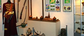
As for Yakubovsky, he also managed to organize the production of Lugadar mineral water, packaged in original glass bottles with a double-headed eagle on them, which suggests that the entrepreneur was awarded the honorary title of “supplier of the Court of His Imperial Majesty.” By the way, one of these bottles is on display at the Luga Museum of History and Local Lore.
That’s why Luga was once so popular among St. Petersburg vacationers.
Many noble families began to build their ancestral nests on Luga land. According to the 1917 census, there were about 500 estates on the territory of the Luga district - almost a third of all estates in the Petrograd province. The estate has always been a kind of psychological refuge, a territory of independence, where the owner felt protected from all the troubles of the outside world. The most famous of them are the Zapolye estate, the Rapti estate, the estates of the Tatishchevs, Obolenskys, and Dashkovs. In the vicinity were the estates of the Vorontsov princes, the Marquis de Traverse, and Baron von Bilderling. At the beginning of the 19th century, A. S. Pushkin visited here several times, stopping on the way from St. Petersburg to the village of Mikhailovskoye. The city of Luga is lucky. First of all, thanks to its favorable location on the way from St. Petersburg to Pushkinogorye. “There is a city of Luga in Russia” - Pushkin’s epigram, provided Luga with wide fame and at the same time determined its ironic perception for a long time.
Estate "Rapti" A.A. Polovtsova A.A. Polovtsov - Secretary of State. The palace was built in the 40s of the 19th century. Authors: Professor of the Academy of Arts I.A. Stefanin and architect P.I. Marschner, designed in the Rococo style. Destroyed during the Second World War. The outbuildings, the manager's house, the guest house, and the park have been preserved.
The excellent natural and climatic conditions and landscapes of the Luga region were appreciated already in the second half of the 19th century. Numerous St. Petersburg residents went here, in the vicinity of Luga, for the summer. Luga and Luga district have gained fame as a popular summer cottage area. There were about 500 master's estates, rented out as dachas or equipped as genuine summer residences of representatives of various strata of the St. Petersburg nobility: statesmen, high aristocracy, large financiers, entrepreneurs, and military personnel. Many memorable places in the area are associated with the vacation stays of famous writers, musicians, artists, and scientists. Thus, a passionate hunter and nature lover N. A. Nekrasov rested on the beautiful banks of the Saba River. Near the Preobrazhenskaya station (now Tolmachevo), the classic Russian satire writer N.B. Saltykov-Shchedrin spent a lot of time. Not far from Lake Vrevo on the Stylevo estate, inspired by natural beauty, N. A. Rimsky-Korsakov created his masterpieces!
Kuprin, Turgenev, Mussorgsky rested here. “Forest Wilderness” - Shishkin’s programmatic work - was created not far from the Serebryanka station. Kramskoy, inspired by the fresh air in the company of Shishkin, worked on the painting “Christ in the Desert.” Well, Prishvin, after studying in Leipzig, served as an agronomist and even published several articles and books in his specialty.
In August 1917, when the Tsarist General Kornilov sought to conquer revolutionary Petrograd, units of the cavalry corps under the command of General Klimov were stopped in the Luga area.
During the Civil War, the city showed courage and resilience in defending Petrograd.
On May 21, the special representative of the political department of the 7th Army of the Petrograd Defense Committee, N. G. Tolmachev, arrived in Luga. He went to the village of Krasnye Gory, where the battalion of the 48th Infantry Regiment was fighting. Suddenly the whites burst into the village. The commissioner himself lay down on the machine gun and then fired back with a revolver. He kept the last bullet for himself. Tolmachev was buried on the Field of Mars in Leningrad. In the Luga district, the former Preobrazhenskaya station and one of the lanes in the center of Luga are named after him.
After the end of the Civil War, the Luzhans began to restore the economy. In 1920, there were 5 communes, 86 agricultural artels and 8 public ploughs.
Before the Great Patriotic War, the city's population exceeded 30 thousand people, there was a crucible plant of Union importance, a foundry-mechanical plant, a sawmill, a tannery, a brick plant, a mechanical workshop, and a power plant. The city had 13 schools, pedagogical and road-building technical schools, 4 clubs, 3 cinemas, 14 libraries, in the area there were 11 sanatoriums, dozens of rest houses and pioneer camps.
The heroic defense of Luga lasted 45 days and nights in the summer of 1941, which was a brilliant example of the courage of the soldiers and commanders of the Red Army, and the people's militia. This made it possible for Leningrad to carry out a number of major measures to mobilize all forces and resources to repel the enemy. For the defense of the Luga line, the Luga operational group was created under the command of General K. P. Pyadyshsva,
During the defense of the Luga line, the Nazis lost more than 10 thousand soldiers and officers, hundreds of tanks and dozens of artillery batteries. On the approaches to Luga, the Nazi 8th Panzer Division ceased to exist. 17 partisan detachments and groups were created behind enemy lines.
On the night of February 11-12, 1944, our troops liberated Luga.
During the Great Patriotic War, five thousand Luzhans were awarded orders and medals of the USSR. Fifteen of them were awarded the title of Hero of the Soviet Union.
In 1975, on a high hill near Luga, the majestic monument “Partisan Glory” was unveiled to the partisans of three regions - Leningrad, Pskov and Novgorod. The city has created a majestic memorial to fallen heroes.
In 1977, the city was awarded the Order of the Patriotic War, 1st degree, for military and labor merits.
Immediately after the liberation of the city, the Luzhans began to restore the destroyed economy. By the early 1950s, the city had risen from ruins.
The city was developed especially intensively in the 1970s - early 1990s.
The city center has been transformed. On the site and near the old market square and vacant lots appeared: a large-scale local administration building, a House of Culture, a square named after V.I. Lenin, a hotel, a communications center, shops, a nine-story residential building.
Complexes of new residential neighborhoods have sprung up in the north and south of the central part of the city.
In the city, existing enterprises were actively developing and new plants and factories were being built: the country's first plant for the production of artificial protein casing "Belkozin", new buildings of the Dairy Factory, Knitting Factory, etc., the network of light and food industry enterprises expanded.
Luga today is a cozy green city. Many of the enterprises survived the difficult period of perestroika and are confidently increasing their production volumes and the number of jobs.
With the formation of the CIS, Luga found itself on the route of economic and trade relations between the three largest regions: the Russian North-West, including the St. Petersburg agglomeration, the Ukrainian-Belarusian, and the Baltic countries.
History shows that cities with similar locations have advantageous conditions for dynamic development.
The resident population as of January 1, 2006 was 82,267 thousand people. The administrative center of the district is the city of Luga.
On January 1, 2006, local government bodies of the Luga municipal district began to exercise their powers in full.
The Luzhsky municipal district includes two urban settlements (Luzhskoye and Tolmachevskoye) and thirteen rural settlements: Volodarskoye, Voloshovskoye, Dzerzhinskoye, Zaklinskoye, Mshinskoye, Oredezhskoye, Osminskoye, Retyunskoye, Serebryanskoye, Skreblovoskoye, Tesovskoye, Torkovichskoye and Yam-Tesovskoye.
Due to its natural resources and beauty, the Luga district can be considered the pearl of the region. Its landscapes are especially picturesque: sometimes low-lying, sometimes hilly, with pine and deciduous forests, numerous lakes, winding riverbeds, streams, and an abundance of meadows and fields.
Being the southernmost district in the Leningrad region, it receives more solar heat than others. For this, and for the healing properties of the air caused by the abundance of coniferous forests, the Luga region is rightly called “Crimea in the north”. Coniferous forests on the sands, many lakes and rivers, more warm sunny days, dry air - all this distinguishes this picturesque corner. The natural resources of the area include an abundance of springs with crystal clear water. For example, a spring on the banks of the Naplotinka River in the northern part of the city of Luga (near the Kyiv highway) has long become one of the symbols of the city, because it quenches thirst and improves the health of not only Luga residents, but also everyone entering or leaving the city. The Luga mineral water deposit is part of the Artesian basin and is used to treat diseases of the musculoskeletal system, neuroses, and the cardiovascular system. Through the hollows and valleys of the region the rivers Luga and its tributaries Oredezh, Yashchera, Saba, Kemka, Verduga, Paguba and others flow to the northwest. All rivers are rich in fish of different species. Numerous rivers and lakes are a haven for lovers of fishing and water tourism. The largest lakes in the Luga region: Vyalye, Strechno, Samro, Cheremenetskoye, Vrevo, Syaberskoye.
The territory of the region south of the Oredezh and Luga rivers amazes with the variety of landscapes. In the northwest of the village of Voloshovo, there is a group of lakes surrounded by beautiful pine forests. The unique South Borovaya reserve is interesting for its flora, where several species of northern orchids are found, as well as a number of rare plants that are not found anywhere else in the Leningrad region.
On the territory of the district there are the largest complex federal reserve in the region “Mshinskoye Bog” (60 thousand hectares), complex reserves - Syabersky, Shalovo-Perechitsky and Cheremenetsky.
Natural monuments - relict forests of the Lime Mountains tract, caves of artificial origin - Korpovskie near Luga and Oredezhskie on the shore of Lake Antonovskoye, boulder fields near the village of Maloye Konezerye, sand dunes near the southern outskirts of the city of Luga, the area of the village of Zhelezo with botanically valuable rocks coniferous and deciduous trees. Among the groundwaters there are mineral waters (Cambrian sodium chloride waters).
A mud bath using sapropel mud from Lake Nelai is included in the balneological complex of the Zeleny Bor health resort.
Geographical composition of the territory: forests occupy more than 60% of the area, swamps - 15%, agricultural lands - 16%.
And today the Luga district is the largest province of St. Petersburg in terms of the number of gardens. Thousands of St. Petersburg residents move to Luga and the surrounding area for the summer to enjoy the silence and the purest balm of pine forests. Here are the famous massifs “Mshinskaya”, “Nizovskaya”, “Divenskaya”. There are many smaller ones scattered along the shores of lakes, in river openings and forest edges of gardening and holiday villages.
Rapti Manor
The remains of the famous estate are located near Lake Cheremenetskoe. The manor was built in the Baroque style and was considered the richest and most luxurious place in the area. Often local residents called it the Versailles of Luga, for the boldness of its architectural solutions.
Many famous people, such as I.N. Kramskoy, we were looking for inspiration here. But during the revolution of 1917, a state farm of the same name was formed here, and in 1918 the estate was classified as an architectural monument and taken under protection, and the NKVD sanatorium was located in the main building. Over time, the village of Rapti was renamed the village of Dzerzhinsky. During the Great Patriotic War, the village was occupied, and in 1944, during the retreat, the Germans blew up the main building of the estate. To this day, only the arch, which miraculously survived, and the remains of the main staircase remind of its former luxury.
Urban architecture
County government
Address: Kirova Ave., 64
The building was constructed at the end of the 19th century.
Architectural complex "Public Places"
Address: Svyazi Lane, 4
The complex was built in the 18th century, and now the fence, central building and outbuilding have been preserved.
City mansion of the early 20th century
Address: st. Tosi Petrova, 11
Train Station
Address: st. Malaya Inzhenernaya
It was built in 1944 under the leadership of architect Baryshkin. Before the war, there was a train station built here in the 19th century. It was destroyed during the battles for the city.
"Partisan Glory"
The memorial complex was built in 1973 and is dedicated to the partisans of the Second World War. The composition itself is located on a hill, in the center of which stands a sculpture of a partisan woman with a machine gun in her hand and a banner. The height of the monument with its pedestal is 20 meters. The memorial complex also includes 13 steles that symbolize 13 units of the partisan movement and a memorial hall in honor of partisan exploits. The staircase near the hill has three bastions, representing three regions: Novgorod, Pskov and Leningrad. Every year here, on May 9, celebrations are held in memory of the heroic deeds.
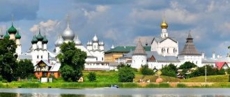
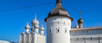
St. John the Theologian Monastery
The establishment of the monastery dates back to the 15th century during the time of John III. It is located on the island of Lake Cheremenets. One of the main shrines is the icon of the Apostle John the Theologian. In 1680, the monastery was attacked by the Lithuanians. The monastic cells were completely burned, but the temples remained intact.
There were two temples: the Church of St. John the Theologian and the Church of the Transfiguration. After the revolution, the monastery was closed and by the 1930s it was given to the artel, and the shrines were arrested. After the Second World War, the main temple was dismantled by order of local officials. The monastery was restored in 1997, and the main shrine, the icon of the holy apostle, was returned to its place in 1999.
Estate "Borovoye"
The estate is located in a pine forest on the shore of Lake Cheremenetskoe. Architect Semyon Petrovich Ivanov created a gorgeous composition in the neoclassical style. The owner of the estate complex was the entrepreneur G. A. Lvov, who needed a country residence for receptions. But the entrepreneur was not destined to use the estate for long. Immediately after the revolution, a home for homeless children was located here. In 1940, the estate was reclassified as a sanatorium for the NKVD. At the moment, a sanatorium of the Ministry of Internal Affairs is located there.
Address: n/a Cheremenets.
Beautiful nature of Luga and its surroundings
In the vicinity of Luga there are many natural monuments: nature reserves, ecological zones and simply beautiful places with unique landscapes.
State Nature Reserve "Shalovo-Perechitsky"
- Coordinates: 58.786858, 29.954722.
The reserve was organized in 1976. Its goal is to preserve the landscape of the middle reaches of the Luga River, which includes glacial topography, broad-leaved forests, pine forests and habitats of rare plants.
This place is replete with picturesque views. His picture is decorated with mirrors of lakes, sandy ridges, green hills and luxurious forests where ancient trees rustle.
The reserve is home to a large number of birds and animals. Here you can meet a stork, a brown hare, a black kite, and in the depths of the thicket - a wild boar and a wolf. The rivers that cross the area are rich in trout.
Due to the above advantages, the reserve has become a popular place for family recreation, ecological and sports tourism, as well as fishing.
Do not forget that this territory is protected by the state. Within its boundaries, logging, making fires in undesignated places, and polluting water and land are prohibited.
State natural landscape reserve "Cheremenetsky"
- Coordinates: 58.567744, 29.873151.
The Cheremenetsky reserve has existed since 1976. On its territory are the largest lakes of the Luga region - Cheremenetskoye and Vrevo, as well as old noble estates and the Cheremenets monastery.
Local lakes are of particular importance because... Rare species of freshwater algae, chara, grow in them. The coastline is surrounded by greenery of small bushes and the shade of oak and elm tree crowns.
Vast meadows, distinguished by a wealth of fragrant herbs and flowers, add variety to the landscape of lakes and forest thickets. “Cheremenetsky” is a place where endangered species of birds and animals are preserved, as well as endangered plants and mushrooms listed in the Red Book of the Russian Federation.
Nature reserve "White Stone"
- Coordinates: 58.742400, 30.433200.
"White Stone" was founded in 1979. Now this is one of the most beautiful reserves in the Leningrad region. Its main task is to preserve swamp systems and protect the inhabitants of pine forests. The territory, which covers an area of 3,000 hectares, is home to countless animals and birds: badgers, wild boars, moose, cranes, wood grouse and many others.
Hunting, picking berries, mushrooms and medicinal herbs is strictly prohibited in the reserve. For ecological recreation, places are designated where travelers can walk away from dangerous swamps and wild animals.
Lake Omchino
- Coordinates on the map: 58.721131, 29.815947.
Lake Omchino is a reservoir of artificial origin that arose as a result of the installation of a dam. Along its coast lies a pine forest, rich in nuts and berries, and in the reed thickets you can see wild birds - herons, swans and ducks.
The lake is popular among outdoor enthusiasts. Ecological trails run through the forest, and boat rentals are available by the water. During the snowy season, the coastal slopes are transformed into ski slopes, and an ice skating rink is set up on the frozen lake. Omchino is also in demand among fishermen. Perch, pike and even crayfish live in the local depths.
Swimming in the lake is not prohibited, but it is not recommended either. The reservoir is fed by springs, which is why the water is quite cold. In addition, there is no comfortable descent into the water. Anyone who wants to swim will have to make their way through hordes of water lilies and reeds.
Borshchevsky caves in Yam-Tesovo
- Address: s. Yam-Tesovo.
These caves appeared at the beginning of the 20th century during the extraction of karst sand for glass production. The length of the underground tunnels was 15 kilometers. When they learned to use quarries to extract sand, the caves became unnecessary and were abandoned.
During the war, these secret tunnels were used by Soviet partisans. Today the Borshchevsky caves serve as attractions for extreme tourists. Most of the underground passages have been filled in, the remaining ones have been strengthened to protect speleologists from collapses.