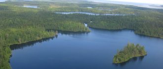
Among the forests and rocks of Karelia is the picturesque Lake Onega - the second largest freshwater lake in Europe. In size it is second only to its older sister, Ladoga. Its area with islands is 9720 square kilometers, the maximum depth is 127 meters, the average is 30. The lake has an elongated shape, from south to north it extends for 248 kilometers, its maximum width is 83 kilometers.
More than 1,150 rivers carry their waters into Lake Onega, the largest of which are Shuya, Suna, Vytegra, Andoma, Vodla. Only 52 of the rivers flowing into the lake are more than ten kilometers long, all the rest are small rivers. But only one river flows out of it - the Svir. The waters of Lake Onega are crystal clear and transparent that the bottom is visible at a depth of up to 4 m.
The largest cities located on the shores of Lake Onega: Petrozavodsk, Medvezhyegorsk, Kondopoga. In general, the shoreline of the lake is sparsely populated, despite the fact that since ancient times people have settled along the banks of rivers and lakes.
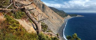
The southern and northern parts of Lake Onega are very different from each other, especially in the structure and contours of the shores. The southern part of the lake is a vast stretch, Central Lake Onega. The flat shores are varied - sandy, rocky, marshy. Completely different shores in the northern part of the lake. They are characterized by unusual geological protrusions called “ram's foreheads” and are rocks polished by a moving glacier, gentle on one side and steep on the other. The coastline of the northern part of the lake is indented; so-called lips are often found - long and narrow bays, especially loved by those who are fond of windsurfing. The lake here is divided into two bays - Big and Small Onega Lake.
A few facts about Lake Onega
Lake Onega was formed after the retreat of the last glaciers. The large tectonic basin of the lake was formed during the pre-glacial period. After the glacier retreated, a large post-glacial lake formed.
- The Old Russian name for Lake Onega is Onego, it was affectionately called Father Onego.
- Onego is called the fresh sea, the water in it contains a minimal amount of minerals and is the second largest freshwater reservoir in Europe;
- The area of Lake Onega is 9,700 square km;
- It ranks 19th in size among lakes in the world, 4th among lakes in Russia and 2nd in Europe after Lake Ladoga;
- The greatest depth in the northern part of the lake is 127 meters, in the middle part - 50-60 meters, towards the southern part the depth decreases and reaches 20-30 meters;
- The age of the lake is 12 thousand years.
- There are 1.5 thousand islands in the lake.
- More than a thousand rivers and streams flow into the lake, one river flows out, the Svir, connecting it with Lake Ladoga.
- Lake Onega is located in Karelia (80%), as well as in the Vologda and Leningrad regions.
Etymology
The exact origin of the name is unknown. In ancient Russian writings it sounds like Onego. For example, academician A.M. Sjögren believes that it comes from the Finnish word ääni, which can be translated as “sound”: it turns out to be a “noisy, sounding lake.” Another version suggests a reference to the Sami languages. A.L. adheres to it. Pogodin: agne can be translated as “sand”, and jegge – “low-lying plain”.
Petroglyphs
Onega petroglyphs
Petroglyphs (images carved on rocks or boulders), located in the Pudozh region of Karelia, are popular attractions of Lake Onega. There are more than 1,100 figures in total, most of them are concentrated on the capes of Peri Nos, Besov Nos and Kladovets.
The most famous Onega petroglyphs are located on Cape Besov Nos - this is the so-called triad: demon, catfish/burbot and otter/lizard.
Coloring pages and puzzles
White Sea petroglyphs. Old Zalavruga.
How to shoot a multi-meter horizontal rock formation with petroglyphs in one shot? Stand on stilts, climb on a stepladder? Photography from a helicopter is impossible: there are high-voltage lines of two hydroelectric power stations around the rock. In addition, a helicopter is dust at the very surface of the earth and vibrations.
You need to take a composite photo. Mark the rocks, remove hundreds of fragments separately and then combine them in the computer using corner markers.
There was another difficulty: the uniformity of lighting in the overall photo. The central part of the canvas of Staraya Zalavruga is a complex macro-relief and a physical size of 12 by 16 meters. Some of the drawings are visible only in the oblique rays of morning light. Another appears in the evening. And during the day, shallowly carved petroglyphs, especially large petroglyphs, are not visible at all.
Karelia. Onega petroglyphs.
We decided to paint the petroglyphs with watercolors and take photographs as soon as possible.
Diary, Zalavruga: • June 4–9, 2006: identifying petroglyphs under a black film with chalk outlines, tinting the embosses with watercolors in two colors • June 10: rain washes off the watercolor • June 11: repeated tinting with checking • June 12–13: marking rocks into fragments of 40x60 cm with corner points secured with pieces of masking adhesive tape • June 14: photographing 523 fragments over 3 hours. The weather is cloudless and sunny. Compensatory adjustments to exposure and color balance were not intentionally made during the shooting • June 15 - wind, rain. Final field work
After the expedition, I spent many hours sitting at the computer. Then, in 2006, Igor Georgievsky for the first time managed to capture a real rock surface with an area of 11 by 15 meters in one frame. And boats, and moose, and hunters.
Chelmuzh braid
Chelmuzh braid
Chelmuzhskaya Spit is a specially protected natural area. It is a sandy cape, stretching for 13 kilometers, covered with pine trees. Width 200-500 meters. The spit was formed as a result of the melting of the glacier. The place is beautiful and quiet, in good weather you can sunbathe and swim here.
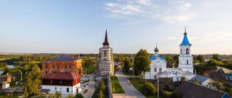
Epiphany Church in the village of Chelmuzhi
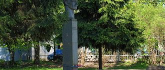
The Chelmuzhskaya Spit stretches along the coast near the ancient fishing village of Chelmuzhi, from which it is separated by a strait. In the village there is the oldest tented wooden church of Peter and Paul, more popularly called Epiphany. It was built in 1605, located on the shore of Lake Onega, next to it there is a cemetery.
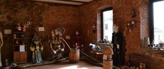
Submarine Museum in Vytegra
Address: st. Komsomolskaya, 15 Phone: 8 (81746) 26-7-29 Website: https://vk.com/club46549527 Opening hours: in summer from 09:00-17:00 seven days a week, the rest of the year closed on Sunday and Monday. Cost: adult without excursion: 170 rubles, adult with excursion: 250 rubles
The Soviet submarine B-440, which at one time plied the seas and oceans, was decommissioned and moved to the shore of Lake Vytegorsk, which is 20 km from Onega.
The boat was converted into a museum, now you can go there and examine everything: the captain’s cabin and the incredibly narrow berths of the rest of the crew. Instead of hatches, the boat has ordinary doors installed for the convenience of visitors. Imagine in this tiny space 80 submariners - the crew of the boat - and wonder how they fit there. All the walls are completely usable space: the boat control unit, control valves, levers, torpedoes. The main value of the boat is its working periscope.
Kizhi
Kizhi
Website: kizhi.karelia.ru/architecture
The most famous attraction of Lake Onega is the Kizhi Pogost or Kizhi, a UNESCO World Heritage Site. Located in Karelia on the island of Kizhi and is an open-air archaeological museum. The best examples of wooden architecture of Russians, Karelians and Vepsians are collected here within the framework of the Kizhi State Historical-Architectural and Ethnographic Museum-Reserve.
The museum collection includes more than 80 buildings, which are divided into sectors: Russian Zaonezhye, Kizhi Necklace, Veps, Kondopoga, Pudozh, Pryazhinsky Karelians, Northern Karelians, as well as the villages of Vasilyevo, Yamka. In Petrozavodsk, several historical buildings also belong to the museum complex.
Kizhi - UNESCO World Heritage Site
UNESCO World Heritage Sites include objects from Russian Zaonezhye:
- Church of the Transfiguration of the Lord;
- Church of the Intercession of the Blessed Virgin Mary;
- Bell tower;
- Fence.
Residents of the eastern part of Onego called Zaonezhye the land on the opposite, western shore of the lake. Now Zaonezhie is called the Zaonezhsky Peninsula and the Kizhi Skerries.
Ruskeala waterfalls
How to get there: by car on the A130 highway;
by bus on the route Sortavala-Vyartsilya, stop “Ruskeala”; with an excursion, which can be booked either at the Northern Ladoga Museum: https://museum-sortavala.ru/ceny.html, or at a travel agency: https://kolmaskarelia.ru/ The waterfalls got their name from the village of Ruskeala, located nearby. The waterfalls are flat, so you won’t see “high water”. But appreciate the beauty of the surrounding landscape, which is praised by every single tourist who has been there. In combination with terraced ledges and trees, the brown-yellow, iron-rich water of the Ruskeala Falls looks unusual. Another nice feature is that the waterfalls never get smaller. Even in the midst of a hot summer, you will see a deep river and powerful streams of water.
On one of the waterfalls there is a log hut - a prop left after the film “The Dark World”. The episode “The Dawns Here Are Quiet” was also filmed here. The area around has now been improved - plastic figures and gazebos for relaxation have been installed.
Andoma Mountain
Andomskaya Mountain or Andom Mountain is located in the Vologda region and is a geological natural monument. Formed during glacial times, the height is about 50 meters above the level of Lake Onega. Andom Mountain is a geological section in which sandstones, clays, sands and marls formed numerous bizarre stripes of a wide variety of shades. Under the influence of the glacier, they formed into bizarre pictures.
Famous islands of Karelia
Balaam
How to get there:
- From St. Petersburg by boat as part of excursion groups.
- From Priozersk by meteor: travel time 1 hour, cost about 2000 rubles. There and back again.
- From Sortavala by meteor - travel time 50 minutes. In summer, meteors occur daily at 9.00, 11.00, 13.15 and 16.00. The cost of round trip travel includes a walking tour: Mon-Fri and Sunday - 2300 rubles per person, Saturday - 2570 rubles per person.
- From Pitkäranta, meteors leave the pier of the Long Beach recreation center. Travel time 1 hour. The cost of round trip travel includes a walking tour: Mon-Fri and Sunday - 2460 rubles per person, Saturday - 2750 rubles per person.
Valaam Island is a unique place with its own unique nature, climate, architecture, and people. Every year, pilgrims and tourists from all over the world come here to touch these holy places.
There are many spiritual places on the island. Of course, the main temple of the island is the Spaso-Preobrazhensky Monastery, the construction of which dates back to the 14th century. On the territory of the monastery there is the Valaam Church, Archaeological and Natural Museum-Reserve, which tells about the history of the island.
The island itself is very green; after a walk along it you can visit the monasteries: Konevsky Igumensky monastery, Resurrection (Red) monastery, Gethsemane yellow monastery, St. Nicholas monastery, St. Vladimir monastery. Another monastery is located on the island of Putsaari. Visiting the skete is possible only with the blessing of the abbot.
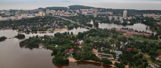
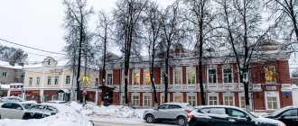
Petrozavodsk
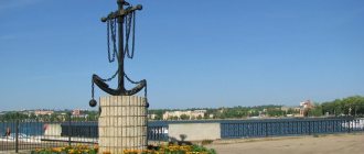
Onega embankment
Petrozavodsk is the main center of civilization in the Republic of Karelia. Like St. Petersburg, it was founded in 1703 by Peter I. The most beautiful place in the city is the Onega embankment, dressed in granite and stretching for 1.5 kilometers.
Lenin Square (Round), Petrozavodsk
The central Lenin Square, the former Round Square, is a historical building of the late 18th century, creating the architectural ensemble of the city. Three streets radiate from the square: Karl Marx Avenue, Zavodskaya and Peterburgskaya streets. Karl Marx Avenue is the oldest street in the city, leading to Onega embankment.
Once upon a time, a monument to Peter I was erected on Lenin Square, but it was replaced by an 11-meter monument to Lenin. Peter I is now located in Petrovsky Square, next to the embankment.
Railway station building, Petrozavodsk
The symbol of Petrozavodsk is the railway station building with a spire, built in the mid-1950s according to the design of architect V.P. Tsipulin
Under the supervision of scientists
Geologists claim that 400 million years ago the entire area around Lake Onega was the bottom of a shelf sea. The modern relief was formed during the next glaciation, which ended 12 thousand years ago. When the ice melted, a basin filled with water formed. The original dimensions of the reservoir were significantly larger than the current ones. However, as a result of water flow along the Svir River over thousands of years, the level dropped by 20 meters, and the lake took on the appearance that we see now.
The first Russians on the lake were the Novgorodians, who were moving towards Pomerania. In 1566, Onega was visited by agents of the London Trading Company, who were traveling from the White Sea to Veliky Novgorod. They left the first hydrographic descriptions of the lake. Onega was mapped in full in the 17th century, but the image was largely erroneous. Only in 1728, surveyor Akim Kleshnin created the first map of Karelia based on instrumental survey, and Onega acquired more accurate outlines.
Monument to Peter I in Petrozavodsk
Lake Onega became of strategic importance under Peter I, as it was part of the route from the Baltic to Arkhangelsk. During this period, the Academy of Sciences was closely involved in studying the lake. Entire expeditions were equipped to Onega. The most productive research was carried out by Academician Ozeretskovsky, who traveled around the lake in the summer of 1785. In addition to hydrographic data, he described minerals and attractions. Even then he noted the beauty of the Church of the Intercession on the island of Kizhi.
Kondopoga
The burnt Assumption Church of the Blessed Virgin Mary in Kondopoga
Kondopoga is the second city in Karelia in terms of population after Petrozavodsk, founded in 1563. The main symbol and landmark of Kondopoga is the Assumption Church of the Blessed Virgin Mary (1774), burned to the ground in August 2022. A unique cultural monument and the best example of Russian wooden architecture was set on fire by a 15-year-old teenager. The church was located in a picturesque place on the shore of Lake Onega.
Currently, funds are being collected for the restoration of the temple.
Carillon at the Ice Palace in Kondopoga
In Kondopoga you can see and listen to carillons; there are two of them in the city. A carillon with 23 bells at the Ice Palace and a carillon with 18 bells on Proletarskaya Street were installed in 2001, made in the Netherlands.
Rodionovo, Church of George Yuksovsky
Address: Leningrad region, Podporozhsky district, Rodionovo village
According to maps, the village is located in the Leningrad region, but this fact does not make the Church of George Yuksovsky located there any less ancient and majestic. The wooden building of the 15th century is the same age as the Church of the Resurrection of Lazarus of Murom, which is now located in the Kizhi nature reserve. The main difference from all other churches is the oldest wooden building, which is and has always been in one place. If you want to see real antiquity, which was practically not touched by the hand of Soviet power, do not be lazy to go to Rodionovo. Moreover, the places around are protected: silence, grace and beautiful nature. By the way, the temple of Georgy Yuksovsky is active and is considered a “place of power.”