Podporozhye
(Leningrad region)
OKATO code:
41236501
Founded:
1936
Urban settlement since:
1937
City since:
1956 City of district subordination (Podporozhye district, Leningrad region)
Center:
Podporozhye district
Telephone code (reference phone)
| 81365***** | 20-33-9 |
Deviation from Moscow time, hours:
0
Geographic latitude:
60°55′
Geographic longitude:
34°10′
Altitude above sea level, meters:
50 Sunrise and sunset times in the city of Podporozhye
Official symbols of the city of Podporozhye
COAT OF ARMS OF PODPOROZHISKY CITY SETTLEMENT , approved by the decision of the Council of Deputies of the municipal formation “Podporozhye Urban Settlement of the Podporozhye Municipal District of the Leningrad Region” dated December 16, 2010 No. 96.
The design of the coat of arms and flag was developed by a team of authors consisting of: Konstantin Sergeevich Bashkirov, Victoria Valerievna Karpunina, Svetlana Yurievna Steinbach.
“In the field, lowered, beveled on the right with silver and azure (blue, light blue) on top of the division - three squares, laid stepwise in accordance with the bevel, each of which is wavyly beveled on the right with azure and silver; a black bear with scarlet (red) claws and teeth and silver eyes ascends across the squares, holding an azure whitefish in its mouth and accompanied at the top left by a scarlet shining sun.
A bear holding a whitefish in its mouth is an indication of the names of the rapids - Medvedets and Sigovets.
The scarlet (red) shining sun is, on the one hand, a reminder of the settlers - pilots from the Msta River, Borovichi district, who, as indicated in local history literature, settled on the banks of the Svir in the 18th century, and on the other hand, a reminder of the masters of wood carving and monuments wooden architecture of Prisvirye.
Three squares, laid stepwise according to the bevel, each of which is wavyly beveled on the right with azure and silver - on the one hand, a reminder of the rapids, on the other, of the Verkhne-Svirskaya hydroelectric power station and the types of navigation along the Svir in the old days.
Silver - purity of thoughts, sincerity, truthfulness, innocence, nobility, frankness, purity, hope.
Chervlen (red) – right, courage, selflessness, love, bravery, fearlessness. A symbol of labor, life-affirming force, holiday, beauty, sun and warmth.
The mob is a symbol of prudence, wisdom, modesty, honesty, antiquity and the eternity of existence.
Azure (blue, light blue) - symbolizes knowledge, truth, honesty, fidelity, impeccability. Azure is a symbol of beauty, softness, greatness.”
The coat of arms was entered into the State Heraldic Register of the Russian Federation on March 29, 2011 under No. 6672
REGULATIONS on the coat of arms of the municipal formation “Podporozhskoe urban settlement of the Podporozhsky municipal district of the Leningrad region”, approved by the decision of the Council of Deputies of the Podporozhsky urban settlement dated December 16, 2010 No. 96.
FLAG OF PODPOROZHISKY URBAN SETTLEMENT , approved by the decision of the Council of Deputies of the municipal formation “Podporozhye urban settlement of the Podporozhye municipal district of the Leningrad region” dated December 16, 2010 No. 96
The flag of the municipal formation “Podporozhskoe urban settlement of the Podporozhsky municipal district of the Leningrad region” is a rectangular panel with a flag width to length ratio of 2:3, reproducing the composition of the coat of arms of the Podporozhsky urban settlement in blue, white, black and red colors.
The flag was entered into the State Heraldic Register of the Russian Federation on March 29, 2011 under No. 6673
REGULATIONS on the flag of the municipal formation “Podporozhskoe urban settlement of the Podporozhsky municipal district of the Leningrad region”, approved by the decision of the Council of Deputies of the Podporozhsky urban settlement dated December 16, 2010 No. 96.
Map
| Podporozhye: maps |
Podporozhye: photo from space (Google Maps) Podporozhye: photo from space (Microsoft Virtual Earth)
| Podporozhye. Nearest cities. Distances in km. on the map (in brackets along roads) + direction. Using the hyperlink in the distance , you can get the route (information courtesy of the AutoTransInfo website) | |||
| 1 | Lodeynoye Pole | 39 (45) | SW |
| 2 | Olonets | 65 (97) | Z |
| 3 | Sheltozero (Republic of Karelia) | 80 (152) | NE |
| 4 | Yarn (Republic of Karelia) | 91 (193) | WITH |
| 5 | Petrozavodsk | 97 (237) | WITH |
| 6 | Syasstroy | 123 (139) | SW |
| 7 | Vytegra | 123 (146) | IN |
| 8 | Novaya Ladoga | 136 (160) | SW |
| 9 | Kondopoga | 142 (291) | WITH |
| 10 | Tikhvin | 145 (207) | YU |
| 11 | Volkhov | 149 (174) | SW |
| 12 | Pikalevo | 155 (251) | YU |
| 13 | Pudozh | 159 (251) | NE |
| 14 | Pitkäranta | 160 (222) | NW |
a brief description of
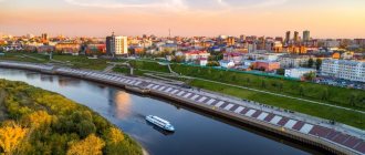
Located within the Svir depression, on the high left bank of the river. Svir (pier), 285 km northeast of St. Petersburg.
Located 4 km from the railway. Podporozhye station on the St. Petersburg - Petrozavodsk line.
Territory (sq. km): 2025
Information about the city of Podporozhye on the Russian Wikipedia website
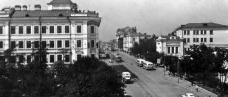
Historical sketch
At the beginning of the 18th century. Peasants from the river were resettled to the area of the modern city by order of Peter I. Station of Borovicheskoe district for organizing navigation on the river. Svir, which was distinguished by its impassable high rapids.
At the end of the 19th century. The villages located at the largest Svir rapids (Sigovets and Medvedets) began to be called Podporozhye.
In 1936, construction of the Verkhnesvirskaya hydroelectric power station began near Podporozhye (launched in 1951), after which the rapids disappeared.
The working village of Podporozhye since 1937. The city since 1956, formed from the settlement of hydroelectric power station builders and nearby villages (the oldest is Podporozhye).
Economy
In Podporozhye: JSC "Podporozhye Timber Industry Enterprise" and "Svirsky Timber Plant". Factory of reinforced concrete bridge structures. Shipyard.
Cascade of Svir hydroelectric power stations.
In the Podporozhye region: logging. They grow potatoes and vegetables. They raise cattle and pigs.
Deposits of gravel, sand, gabbrodiabase.
Universities of the city
St. Petersburg Institute of Foreign Economic Relations, Economics and Law (Podporozhye branch)
187780, Leningrad region, Podporozhye district, Podporozhye, st. Isaakova, 19
Museums, galleries, exhibition halls
Podporozhye Museum of Local Lore 187780, Leningrad region, Podporozhye district, Podporozhye, st. Isakova, 1 Phone(s): (81365) 2-01-28
Architecture, sights
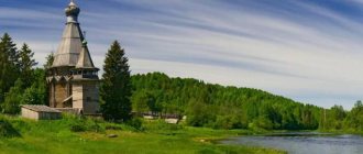
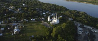
Not far from Podporozhye, in the villages of Kurkovo and Sogintsy, rare pillar-shaped churches from the 17th century have been preserved. The height of the church in Sogintsy is more than 32 meters. Interesting are the wooden churches of the 17th and 18th centuries. in Zaozerye and Posad.
Vepsian Forest Nature Reserve. The Svir River is the southern border of the reindeer nomads.
| Population by year (thousands of inhabitants) | |||||||
| 1939 | 13.3 | 1996 | 22 | 2007 | 19.3 | 2015 | 18.0 |
| 1959 | 17.6 | 1998 | 21.4 | 2008 | 19.0 | 2016 | 17.9 |
| 1967 | 20 | 2000 | 21.0 | 2010 | 18.7 | 2017 | 17.7 |
| 1970 | 21.5 | 2001 | 20.7 | 2011 | 18.7 | 2018 | 17.3 |
| 1979 | 23.9 | 2003 | 20.3 | 2012 | 18.5 | 2019 | 16.9 |
| 1989 | 23.3 | 2005 | 19.9 | 2013 | 18.3 | 2020 | 16.7 |
| 1992 | 23.1 | 2006 | 19.6 | 2014 | 18.2 | 2021 | 16.5 |
Literature
- Shevchuk Yu.S.
Leningrad region. Illustrated guide. St. Petersburg, Discourse Media, 2003. pp. 58-59 - Pospelov E.M.
Geographical names of the world: Toponymic dictionary: About 5000 units. M.: Russian dictionaries, Astrel Publishing House LLC, AST Publishing House LLC, 2001. p. 334 - Ch.
ed. Gorkin A.P. Geography of Russia: encyclopedic dictionary. M.: Great Russian Encyclopedia, 1998. p. 460 - Ch.
ed. Lappo G.M. Cities of Russia: encyclopedia. M.: Great Russian Encyclopedia, 1994. p. 359
Administrative and municipal status[edit]
As part of its administrative divisions, Podporozhye serves as the administrative center of Podporozhye District. [1] Administratively, it, together with thirteen rural settlements, is included in the Podporozhsky district as the municipal formation “
Podporozhye Settlement”
.
[1] As a municipal division, Podporozhsky municipal settlements are included in the Podporozhsky municipal district as the Podporozhsky urban settlement
. [5]
Economics and transport
The economy of the Podporozhye region is dominated by the logging industry. This is due to the availability of a large number of resources. The rest of the industry need not be considered; it can be noted that it occupies a share of less than one percent of total production in the region. It is also worth noting the Verkhnesvirskaya hydroelectric power station, which supplies the area with electricity.
The level of registered unemployment is slightly higher than the regional average. In general, the Podporozhye district cannot be called economically prosperous, largely for the reason that only one industry predominates in the economy. This partly explains the population decline, which often leaves in search of promising work. However, the area has some potential.
The main transport route of the Podporozhye region is the Vologda – Medvezhyegorsk highway. The St. Petersburg – Petrozavodsk railway line also passes through the area.
Attractions
More than 120 historical and architectural monuments are registered in the Podporozhye district. It is worth noting that many of them are in urgent need of restoration. This especially applies to wooden buildings, which are of the greatest value. Among the most significant objects are:
Of interest is the village of Verkhniye Mandrogi, which is one of the most visited sites in the Podporozhye region. Many tourists come specifically here. Also among the interesting places and attractions it is worth noting the Museum of Vodka and Moonshine, which is located in the village of Verkhniye Mandrogi.
There are also annual events that may be of interest as well. For example, the annual holiday of the Vepsian people is the “Tree of Life”.
Recreation and fishing
The Podporozhye region will be of interest to fishing lovers, there are many lakes and interesting rivers (not only the Svir). There is also a tourist infrastructure, in particular not only hotels, but also guest houses and recreation centers with the possibility of renting boats. Of course, people go here for fishing less often than in Karelia, but in the Leningrad region this is one of the most interesting areas from this point of view.
As we wrote above, there are also interesting sights here, but in addition, there are many beautiful places in the Podporozhye region, so those who like to camp with tents can also feel comfortable here. If you wish, you can come up with interesting walking or cycling routes.
Video
Source
Links[edit]
Notes[edit]
- ^ abcdefgh Area Law No. 32-oz.
- ^ abcdef “Archival copy” Podporozhsky district (August 1927 - February 1963, January 1965) (in Russian). System of classifiers of executive bodies of state power of St. Petersburg. Archived from the original on March 10, 2014. Retrieved March 10, 2014.CS1 maint: archived copy as title (link)
- ^ a b Federal State Statistics Service (2011). “All-Russian Population Census 2010. Volume 1" [All-Russian Population Census 2010, vol. 1]. All-Russian Population Census 2010 [All-Russian Population Census 2010]
. Federal State Statistics Service. - "26. The size of the permanent population of the Russian Federation by municipalities as of January 1, 2022". Federal State Statistics Service. Retrieved January 23, 2022.
- ^ abcde Law No. 51-oz.
- "On the Calculation of Time". Official Internet portal of legal information
. June 3, 2011. Retrieved January 19, 2022. - Post office. Information and computing center of OASU RPO. ( Post office
).
Search for postal service objects ( postal Search for objects
) (in Russian) - ↑
Federal State Statistics Service of Russia (May 21, 2004).
“The population of Russia, the constituent entities of the Russian Federation as part of federal districts, urban settlements, settlements, settlements is 3 thousand or more people” [Population of Russia, its federal districts, federal districts, districts Urban settlements, rural settlements - administrative centers and rural settlements with a population of over 3,000] (XLS). All-Russian Population Census 2002
. - “All-Union Population Census of 1989. The actual population of the union and autonomous republics, autonomous regions and districts, territories, negative phenomena, urban settlements and villages. Archival copy” Lodeynopolsky district (in Russian). System of classifiers of executive bodies of state power of St. Petersburg. Archived from the original on December 28, 2013. Retrieved March 11, 2014.CS1 maint: archived copy as title (link)
- Information on the socio-economic situation for the 1st half of 2012 (in Russian). Administration of the municipal district "Podporozhsky municipal district of the Leningrad region". Retrieved November 24, 2012.[ permanent dead link
] - Monuments of history and culture of the peoples of the Russian Federation (in Russian). Ministry of Culture of Russia. Retrieved June 2, 2016.
- Podporozhye Museum of Local Lore (in Russian). Russian Cultural Heritage Network. Retrieved November 27, 2012.
Economics [edit]
Industry[edit]
Gateway of the Verkhne-Svirskaya hydroelectric power station
In Podporozhye there are enterprises of both the construction and food industries. [12] Verkhnesvirskaya hydroelectric power station is located in Podporozhye.
Transport[edit]
The railway connecting St. Petersburg and Murmansk passes through Podporozhye.
An asphalt road passes through Podporozhye, connecting Lodeynoye Pole with Vytegra in the Vologda region. There are also local roads.
The Svir River is navigable and is part of the Volga-Baltic Waterway, connecting the Volga and Neva river basins. The waterway is regularly used by cruise and cargo services.