Population and administrative structure
The population of the Tikhvin region is 69.8 thousand people. There is a natural decline; the maximum in the history of modern Russia was recorded in 2006 – 74.4 thousand people. 83% of the population lives in urban areas, which is slightly higher than the average urbanization rates in the Leningrad region. The national composition is dominated by Russians.
It consists of the Tikhvin urban settlement (20 settlements and 59.9 thousand population), as well as 8 rural settlements. They include a total of 198 settlements, but it is worth noting that only 21 have populations of more than 100 people.
Table. Rural settlements of the Tikhvin region.
| Name | Center | Population | Settlements included |
| Borskoe | Bor village | 1600 | 11 |
| Gankovskoe | Village Gankovo | 1070 | 30 |
| Gorskoe | Gorka village | 1000 | 22 |
| Koskovskoe | Village Koskovo | 680 | 21 |
| Melegezhskoe | Village Melegezhskaya Mountain | 1000 | 13 |
| Pashozerskoe | Village Pashozero | 500 | 15 |
| Tsvylevskoye | Tsvylevo village | 1650 | 31 |
| Shugozerskoe | Shugozero village | 2400 | 35 |
Geography, relief and climate
The area of the Tikhvin district is 7018 square kilometers. It borders with the Novgorod and Vologda regions, as well as with the Volkhov, Kirishi, Podporozhsky and Boksitogorsky districts of the Leningrad region.
Mostly covered with forest (84% of the territory), there are many swamps. There are also a lot of berries and mushrooms here. There are many rivers and lakes in the Tikhvin region, however, only a few are large. Among the lakes these are Shugozero, Pashozero, Dolgozero, Kapshozero, Kharaginskoye, which (except for the first) are located in the northeastern part. The largest rivers are Syas and Pasha.
The climate is temperate continental. Winters are mild, summers are moderately warm. The average annual precipitation is 750 millimeters. In general, the weather in the Tikhvin region does not differ too much from the average throughout the region; air masses that come from the Atlantic Ocean also have a great influence here.
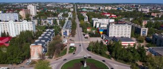
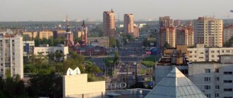
Main streets of Tikhvin
- The central city thoroughfare is Karl Marx Street. From Freedom Square to the eastern outskirts of the city, its length is 4.5 km. Bus routes No. 3, 4, 7, 10 pass here. There are many restaurants, cafes, and hotels along the street. To the north of the bridge over the Vyazitsky stream stretches the Herouville Saint-Clair park.
- Sovetskaya Street (6 km) leads from Station Square to the north-west, passes by Freedom Square, the Assumption Monastery, along the bridge over the Tikhvinka leading to the Vvedensky Convent and further to the “Airplane” stop at the fork in the routes when leaving the city. Buses No. 4, 7, 13, 14 go along this street.
- The map of Tikhvin with a panorama of streets clearly shows how Chernyshevskaya Street leads from the completely modern urban landscapes of the Vokzalny district deep into the ancient landscapes with wooden buildings of the 19th century. The Znamensky Church (XVIII century) is located on it, the street ends in the green area of the Summer Garden.
Economics and transport
The basis of the economy of the Tikhvin region is wood processing, industrial production and agriculture. It is worth noting that the area has historically been agricultural and in recent years active steps have been taken to develop this particular industry. The level of registered unemployment is slightly higher than the regional average - more than 1%. The largest enterprise is the carriage building plant.
The A114 Vologda - Novaya Ladoga highway passes through the area, as well as the 41A-009 highway. The main transport hub is the city of Tikhvin, from which there are two railway lines to St. Petersburg (via Kirishi and Volkhov).
Transport connection
The city of Tikhvin has a convenient transport location. Roads and railways pass through it, connecting St. Petersburg with the northeastern and eastern regions of the country. This is the St. Petersburg - Vologda highway, as well as the eastern branch of the Oktyabrskaya Railway, connecting St. Petersburg with Vologda, Cherepovets, Arkhangelsk, and the cities of the Urals.
Distance from St. Petersburg to Tikhvin:
- by rail - 198 km.
- By highway - 218 km.
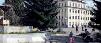
Attractions
The Tikhvin district cannot be called rich in attractions; there are mainly historical or architectural monuments here. Among them are:
- Tikhvin Museum of Local Lore;
- House-Museum of N.A. Rimsky-Korsakov;
- Tikhvin Dormition Monastery.
There are no natural attractions, although there are quite a lot of beautiful and interesting places. We can highlight the Vepsian forest, which is partially located on the territory of the Tikhvin region. Fans of monasteries and churches will not remain indifferent either; there are a lot of them here and most of them have interesting architecture.
Tikhvinsky district is located in the northeast of the Leningrad region. In the west it borders with the Volkhov and Kirishi districts, in the south with the Novgorod region and Boksitogorsk district, in the east with the Vologda region and Boksitogorsk district, and in the north with the Lodeynopolsky district. The territory of the district is divided into 9 municipalities - 1 urban settlement and 8 rural settlements. The number of settlements is 198. The administrative center of the district is the city of Tikhvin .
The district covers an area of 7018 sq. km. The number of residents of the district in 2012 was 76,855 people.
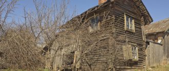
The history of the Tikhvin land goes back centuries. The surrounding area of the modern city was inhabited in the 3rd–2nd millennia BC. Since the 1st century AD, the Ves tribe lived here - one of the Baltic-Finnish tribes of the north-west of the Russian Plain. In the 9th–10th centuries, the Slavs came here, and the region became part of the Russian state.
The first mention of the Prechistensky churchyard on the Tikhvin dates back to 1383. The Resurrection Chronicle contains a story about the miraculous appearance of the icon of the Mother of God, which later became known as the Tikhvin icon, and the construction of the wooden Assumption Church.
In the 16th century, the Tikhvin churchyard became the intersection of several important trade roads. Here was the closest route by land from the banks of the Neva, from the cities of Oreshek and Ladoga (now Petrokrepost and Staraya Ladoga) to Moscow and the land road from Novgorod to the coast of Lake Onega and further to the White Sea; there was also a convenient waterway - along Tikhvinka and Syasi to Lake Ladoga. Thanks to this crossing of trade routes, Tikhvin began to develop in the 16th century as a trading village, first serving the immediate surroundings and then more distant corners of the Novgorod land. Residents of the Tikhvin churchyard, who had previously been only peasants, began to engage more in trade.
The Moscow government, taking into account the importance of the Great Tikhvin Monastery in the state defense system and trying to provide it with funds for the maintenance of fortifications and their permanent garrison, allocated numerous land holdings to the monastery. The peasants living on these lands became his serfs and had to bear heavy feudal duties. From 1560 and for more than two centuries, Tikhvin was a city that entirely belonged to one feudal serf lord - the Great Tikhvin Monastery .
Tikhvinsky Posad in the 17th century, judging by the plan, was not directly adjacent to the monastery fortifications. The fortified monastery estate was surrounded by numerous gardens, vegetable gardens, meadows, and outbuildings. The urban complex developed around the shopping and public center of Posad - the market square, where the main roads - streets - converged. In the southwestern part of the square there were shopping arcades, in the eastern part there was the Church of the Transfiguration, in the northern part there was a customs office.
On March 21, 1773, upon the proposal of the Novgorod governor, Tikhvinsky Posad officially received city rights. On July 10 of the same year, Tikhvin and 27 churchyards with a population of over 25 thousand people were assigned to it. On August 24, it became a district city of the Novgorod governorship, and with the formation of the Novgorod province in 1789, its full-time city.
Since 1918, the city of Tikhvin and Tikhvin district were part of the newly formed Cherepovets province.
Tikhvinsky District , which is the successor to Tikhvinsky Uyezd, was formed in September 1927 as part of the Leningrad Okrug of the Leningrad Region. In 1930, due to the liquidation of the districts, it entered directly into the region.
During the Great Patriotic War, the area suffered significantly.
In 1963, the Tikhvin rural district was formed as part of the former Boksitogorsky, Kapshinsky and Tikhvinsky districts. At the same time, the city council of workers' deputies of the city of Tikhvin was transferred to the subordination of the Leningrad regional (industrial) Council of workers' deputies. In 1965, the Tikhvin rural district was transformed into a district, and the Boksitogorsk district was again separated from its composition.
Today, the leading sectors of the region's economy are industry and agriculture. The largest share in economic output comes from industrial enterprises – 74.0%.
The region is characterized by relatively mild winters with an average temperature of -7°C to -11°C, frequent thaws and moderately warm summers, on average from +15°C to +22°C.
The water surface of the region is formed by rivers with a total length of 2500 km (the largest are Pasha , Syas ) and 146 lakes with a total area of 112 sq. km.
The territory of the region is geographically located in the southern taiga zone and is 84% occupied by forests. Especially large forests are located in the north and northeast of the region. More than half of the forests are represented by coniferous trees - pine, spruce; The most common deciduous trees are birch and aspen.
The flora of the region is diverse: there are more than 30 species of medicinal plants alone. The fauna of the area is represented by such animals as hare, squirrel, badger, raccoon, marten, fox, large ones: elk, wolf, quite rare due to severe extermination by humans - bear, lynx. In total, there are about 50 species of animals in the forests of the region. Of the 250 species of birds living in the area, the most common are: hazel grouse, black grouse, gray partridge, several species of ducks and waders, and capercaillie is also common.
The A114 highway passes through Tikhvin .
Attractions of the area include:
Big Mother of God Dormition Monastery
(XVI-XVII centuries, active), Tikhvin, tel. (81367)51-669
Assumption Cathedral (1515, the pearl of the Russian North, the site of the 500-year-old location of the Tikhvin Icon of the Mother of God, active), Tikhvin, Big Mother of God Assumption Monastery.
Vvedensky Convent (XVI century), Tikhvin, Zaitseva St.
Spaso-Preobrazhensky Cathedral (XVIII century, active), Tikhvin, Svoboda Square.
Znamenskaya Church (XVIII century, active), Tikhvin, Znamenskaya St.
Church of All Saints (Regimental Church), Tikhvin, Rimsky-Korsakov St., 12, tel. (81367)51-267,51-509
House-Museum of N.A. Rimsky-Korsakov , Tikhvin, Rimsky-Korsakov str., 12, tel. (81367)51-267,51-509
Tikhvin Historical and Memorial Architectural and Art Museum (Tikhvin, Big Mother of God Assumption Monastery), tel. (81367)52-080
Churches of the XVII-XVIII centuries. in the village of Gorka (Pash-Kozhesky Pogost). Church of the Intercession of the Blessed Virgin Mary (1859)
Churches and chapels in dd. Kobyakovo, New.
Estate (family estate) of the Rimsky-Korsakovs , Tikhvin district, village of Zaruchevye.
Church of St. Nicholas the Wonderworker , village of Zaruchevye (1711).
Church of St. Nicholas the Wonderworker , village Isakovo (1906)
Church of the Three Saints , p. Kobyakova Gorka (1854).
Church of the Tikhvin Icon of the Mother of God , Novinka village (Between 1857 and 1861).
Chapel of the Assumption of the Blessed Virgin Mary , village of Kharagenichi (1823).
Natural Park "Vepsian Forest" (northeast of the Tikhvin region), tel. (81367) 73-969
Tsaritsyno Lake (the legends of the times of Ivan the Terrible are also legendary).
Settlement – burial mound culture of the 9th-10th centuries.
Handicraft pottery.
Official website of the district and city administration: www.tikhvin.org
Recreation and fishing
The Tikhvin region is not very interesting from the point of view of the average tourist. There are few interesting places here, no significant sights. The tourism infrastructure is rather poorly developed. If you are transiting through the area, you can visit the most significant attractions that we noted above. Of interest are the monasteries, which often stand in amazingly beautiful places.
From a fishing point of view, the Tikhvin region is more interesting; there are a fairly large number of good lakes. However, there are very few recreation centers or guest houses here, so you can mainly find local fishermen or those who prefer to live in tents. The most interesting for fishing is the northeastern part of the region, where there are practically no settlements, but there are many lakes. If you are going fishing or just relaxing in nature, then it is best to go here.