Nature
The region is located predominantly on the plain. In the western part it is hilly and elevated, and in the eastern part it is flat and lowland.
The climate is moderate continental, with well-defined seasons, including transitional ones. Summers are warm and winters are moderately cold. In the east of the region, winters are colder and summers are hotter. The average annual precipitation is 713 mm.
The river network belongs to the Volga River basin.
The vegetation is represented by forests and meadows. In the north, coniferous spruce forests predominate, in the south – coniferous-broad-leaved, deciduous forests.
Moscow region, brief information.
Brief information about the Moscow region:| The date of formation of the region is January 14, 1929. The location of the regional administration is Moscow (it is a separate subject of the federation). | |
| Government organizations: | |
| Architecture: | Reception telephone numbers: tel.: 629-66-30; 629-54-01; tel./fax: 629-23-93 Address: 107031, Moscow, Stoleshnikov lane, 7, building 1. |
| Administration: | 103070, Moscow, Staraya Square, 6 fax: 628-98-12 website: www.mosreg.ru, House of Government of the Moscow Region: 143407, Moscow Region, Krasnogorsk-7, Stroiteley Boulevard, 1 |
| Cadastral Chamber: | Address: 143026, Moscow region, Odintsovo district, r.p. Novoivanovskoye, st. Agrokhimikov, 6a Phone Fax: (495) 741-43-90 |
| Rosnedvizhimost: | 107140, Moscow st. Top. Krasnoselskaya, 7 building 1 Tel. Fax |
Geographical position
. The Moscow region is located between the Oka and Volga rivers. Borders: in the south - with the Tula region, in the southwest - with the Kaluga region, in the west - with the Smolensk region, in the northwest and north - with the Tver region, in the northeast - with the Yaroslavl region, in the north and north- in the east - with the Vladimir region, in the southeast - with the Ryazan region.
Natural conditions
. The terrain of the region is mostly flat; in the west and north of the region there are the Smolensk and Moscow uplands, the highest (up to 285 m) and hilly part of which is the Klinsko-Dmitrovskaya ridge; in the east there is the swampy Meshchera lowland. Main rivers: Oka, Moscow (with tributaries Ruza, Istra, Yauza, Pakhra), Klyazma. On the Moscow River and the Canal. Moscow - a network of reservoirs; On the territory of the region there are lakes (Trostenskoye, Nerskoye, Chernoye) and swamps. The climate is moderate continental; the average January temperature is -10 degrees, the average July temperature is +17 degrees; precipitation amount is from 450 to 650 mm per year. On the territory of the Moscow region, predominantly soddy-podzolic soils are common, in the south of the region - light gray soils. Vegetation: mixed forests.
Relief
The relief of the Moscow region is predominantly flat; The western part is occupied by hilly hills (heights more than 160 m), the eastern part by vast lowlands.
From southwest to northeast, the region is crossed by the border of the Moscow glaciation; to the north of it, glacial-erosive forms with moraine ridges are common, and to the south - only erosional relief forms.
Almost the entire west and north of the Moscow region is occupied by the moraine Moscow Upland with well-defined river valleys, the highest average height (about 300 m, in the Dmitrov area) is within the Klinsko-Dmitrovskaya ridge, and the highest point (310 m) is near the village of Shapkino, Mozhaisk district . The northern slope of the Moscow Upland is steeper than the southern one. Lakes of glacial origin are frequent within the elevation (Nerskoye, Krugloye, etc.). To the north of the named elevation there is a flat and heavily swampy alluvial-outwash Upper Volga lowland, the height of which is no more than 150 m; includes the Shoshinskaya and Dubninskaya lowlands (heights less than 120 m).
In the south of the region stretches the hilly moraine-erosive Moskvoretsko-Oka Plain, which has its greatest height (255 m) in the area of Teply Stan (located within Moscow), with clearly defined (especially in the southern part) river valleys; Karst landforms are occasionally found within its boundaries. The latter are especially common in the Serpukhov region.
In the extreme south of the region, beyond the Oka, there are quite high (more than 200 m, maximum height 238 m) northern spurs of the Central Russian Upland with numerous ravines and ravines. These are the Zaokskoye erosion plateau and the Zaosetra erosion plain.
Almost the entire eastern half of the Moscow region is occupied by the vast Meshchera Lowland, which in its eastern part is significantly swampy; its highest hill is 214 m above sea level; heights of 120–150 m predominate; river valleys are poorly expressed. Almost all large lakes of the Meshchera Lowland (Chernoe, Svyatoe, etc.) are of glacial origin. Here is also the lowest natural height in the region - the water level of the Oka - about 97 meters.
Geological structure and minerals
The territory occupied by the Moscow region is located in the central part of the East European Platform; the latter, like all platforms, consists of a crystalline foundation and sedimentary cover. The crystalline basement consists of rocks of Archean and Proterozoic age, and the sedimentary cover contains sediments of the Paleozoic, Mesozoic and Cenozoic eras. The smallest depths of the crystalline basement (1000 m) are to the south of the city of Serebryanye Prudy (in the extreme south of the region), the greatest (4200 m) are to the east of Sergiev Posad (in the northeast of the region).
Within the Moscow region there are almost no deposits of the Tertiary period; deposits of the Carboniferous and Jurassic periods are much more widespread.
During the Cretaceous period, there was a sea on the territory of part of the modern Moscow region, as evidenced by outcrops of phosphorites and various sands. Cretaceous deposits are most common in the north of the Moscow region. The Jurassic sea was larger than the Cretaceous sea; characteristic Jurassic deposits (in the form of black clays) are found both on the territory of Moscow and in its immediate surroundings, especially in the valley of the Moscow River. Carboniferous deposits in the Moscow region are represented by dolomites, limestones and marls. Outcrops of coal deposits rich in organic residues occur in the south (especially in the Serpukhov region) and in the west of the region. Devonian deposits were also discovered on the territory of the Moscow region.
Quaternary deposits are widespread in the Moscow region; their power decreases from northwest to southeast. Currently, most researchers have accepted the point of view according to which there were four glaciations in the Moscow region. The first of them, Oka, occurred in the Lower Pleistocene and spread to the latitudinal segment of the Oka valley; it left almost no traces on the territory of the region. In the Middle Pleistocene there were two powerful glaciations - the Dnieper (covered a significant part of the territory of the Russian Plain) and the Moscow (stopped slightly south of the current border of Moscow). Finally, the Valdai glaciation dates back to the late Pleistocene, which did not directly affect the territory of the Moscow region, but left traces in the form of fluvioglacial deposits (mainly in the north of the region). The periods between glaciations correspond to the Likhvin, Odintsovo, Mikulin and Mologo-Sheksna interglacials. The glaciers left behind moraine loams with pebbles and boulders of various types (granites, gneisses, quartzites; dolomites, limestones, sandstones). In areas of terminal moraine ridges, the thickness of sediments sometimes reaches 100 m; on watersheds it usually does not exceed several meters.
Minerals
The Moscow region is rich in a variety of mineral resources.
Sands found in deposits of various periods (mainly Quaternary and Cretaceous) are of high quality and are widely used in construction; quartz sands are used in the glass industry; they have been mined since the end of the 17th century in the Lyubertsy region; Some of the deposits are currently mothballed for environmental reasons; only the Eganovskoye deposit is being developed (quartz sand reserves - 33 million tons, annual production - up to 675 thousand tons per year). Sand and gravel deposits are common within the Smolensk-Moscow Upland. Sandstone deposits are being developed in the Klin and Dmitrov regions.
Clay deposits are also numerous within the Moscow region; deposits of low-melting clays are being developed in Sergiev Posad. The Eldiginskoye deposit near the village of Sofrino stands out; raw material reserves are estimated at 30 million cubic meters, annual production - up to 600 thousand cubic meters in Dmitrov, Lukhovitsky, Serpukhov and other regions). Refractory white clays are found in the east of the region (in deposits of the Carboniferous and Jurassic systems) and have been mined since the 14th century in the Gzhel region; The largest deposit is Kudinovskoye near the city of Elektrougli with raw material reserves of 3 billion tons. Covering loams used in brick production are very widespread.
The Moscow region has long been famous for its limestones (“white stone”), which are soft to work with. The Myachkovskoye deposit of rubble limestone is famous, the raw materials of which were used for cladding the walls of such Moscow buildings as the Bolshoi Theater and others; Limestone mining in Myachkovo has now been stopped; Currently, Carboniferous limestones are mined in quarries in the Podolsk, Voskresensky, and Kolomensky districts. There are known deposits of marble-like limestone, such as in the Kolomna region.
In the region, deposits of other carbonate rocks have been discovered - dolomites (used in the cement industry; production is concentrated mainly in the area of the city of Shchelkovo, dolomite reserves at the Shchelkovo deposit are over 20 million tons, annual production is about 650 thousand tons), limestone tuffs, marls, etc., located mainly in the south and east of the region.
The Moscow region has phosphorite deposits; here are the most important Yegoryevskoye and Seversky deposits in the Moscow region.
The area of the Meshchera Lowland is rich in peat deposits; There are also peat deposits in the Upper Volga Lowland. The largest operating deposits are Ryazanovskoye (840 thousand tons per year) and Radovitsky Mokh (760 thousand tons per year) (both are located in the Yegoryevsky district and belong to OJSC Shaturtorf). Of the combustible mineral resources in the region, there is also brown coal (in the Zaoksky districts, the interlayers belong to the Moscow region brown coal basin), the deposits are of no industrial importance and are not developed.
Within the region, minor deposits of iron ores (in the Serpukhov and Serebryanoprud regions) and titanium are known.
Deposits of potassium salt have been explored (in the Serpukhov and Yegoryevsk regions).
In the Moscow region there are also numerous mineral springs, especially ferruginous ones (near Zvenigorod, Serpukhov, Klin). In addition to open springs, many layers rich in mineral water were discovered at depths of 300-500 meters. At a depth of 1-1.5 km, a buried salt sea of a significant area was discovered, presumably occupying the territory of not only Moscow, but also several neighboring regions. Salt water with a salt concentration of up to 300 g/l is used in the local food industry, balneological centers, and also at water sports facilities.
Climate
The climate of the Moscow region is moderate continental, seasonality is clearly expressed; summers are warm, winters are moderately cold; continentality increases from northwest to southeast.
The period with an average daily temperature below 0 *C lasts 120-135 days, starting in mid-November and ending at the end of March. The average annual temperature in the region ranges from 2.7 to 3.8 *C. The coldest month is January (average temperature in the west of the region is -10 *C, in the east -11 *C). With the arrival of arctic air comes severe frosts (below -20 *C), which last up to 40 days during the winter (but usually frosty periods are much shorter); in some years frosts reached -45 *C (the lowest absolute minimum temperature was recorded in Naro-Fominsk -54 *C). In winter (especially in December and February), thaws are frequent, caused by Atlantic and (less often) Mediterranean cyclones; They are, as a rule, short-lived, their average duration is 4 days, the total number from November to March is up to fifty. Snow cover usually appears in November (although there have been years when it appeared at the end of September and in December), disappears in mid-April (sometimes earlier, at the end of March).
Permanent snow cover usually sets in at the end of November; snow cover height is 25–50 cm. Soils freeze to 65–75 cm.
The warmest month is July (average temperature +17 *C in the west and +18.5 *C in the southeast). The maximum summer temperature (+39 *C) was recorded in Zaraysk. The average annual precipitation is 450-650 mm, the northwestern regions are the most humidified, the southeastern regions the least. In the summer months, an average of 75 mm of precipitation falls, but once every 25-30 years, severe droughts occur in the Moscow region, when less than 5 mm of precipitation falls.
Hydrography
Map of the Moscow province from the Encyclopedic Dictionary of Brockhaus and Efron
All rivers of the Moscow region belong to the Volga basin (the Volga itself flows through the region in a small area along which the border with the Tver region passes).
The northern part of the region, including the entire Upper Volga lowland, is irrigated by tributaries of the Volga (Shoshey, Lama, Dubnaya, Sestra, Yakhroma), while the southern part is irrigated by tributaries of the Oka (Lopasney, Nara, Protva, etc.), which is the largest river after the Volga in the Moscow region. The tributaries of the Moscow River, which flows within the Moscow region for most of its length, also belong to the Oka basin. The eastern and northeastern regions of the region, including a significant part of Meshchera, are irrigated by tributaries of the Klyazma, which is one of the main tributaries of the Oka and originates within the Moscow region.
In total, there are over 300 rivers in the Moscow region, with a length of more than 10 km. All rivers have a calm flow, well-developed valleys and floodplains; Snow feeding predominates, with high water occurring in April - May. In summer, the water level in the rivers of the Moscow region is low and rises only in cases of prolonged rain. The region's rivers are covered with ice from late November to mid-April. Of the rivers, only the Volga, Oka and Moscow are navigable.
The northern part of the Moscow region is crossed by the Moscow Canal, passing through the Ikshinskoye, Klyazminskoye, Pyalovskoye and Pestovskoye reservoirs. In the Moscow River basin, the Ozerninskoye, Mozhaiskoye, Istrinskoye and Ruzskoye reservoirs are also formed, providing Moscow and the Moscow region with drinking water.
There are many lakes in the Moscow region (about 350), almost all of them are shallow (5-10 m), many are of glacial origin. The largest are Senezh (15.4 km2) and Svyatoe (12.6 km2). The deepest - 32 meters - Lake Glubokoe in the Ruza region.
Swamps are common in the Moscow region, especially within the Meshcherskaya and Upper Volga lowlands.
Soils
On the territory of the Moscow region, low-fertility soddy-podzolic soils that require fertilizers predominate (in the uplands - loamy, medium and strong podzolization; in the lowlands - soddy-podzolic swamp sandy loam and sandy soils. Chernozem soils (heavily podzolized and leached) are not widespread and have place only south of the Oka. Gray forest soils are common from the south of the Oka and in the interfluve of Moscow and Klyazma (mainly Ramensky and Voskresensky districts). Swamp soils are often found in the Meshcherskaya and Upper Volga lowlands. Along the valleys of large rivers - alluvial soils. Soils of the Moscow regions are heavily polluted with mineral fertilizers and pesticides, as well as household and industrial waste, garbage.The degree of soil contamination is especially high in the suburban area of Moscow, as well as in the east (in the Orekhovo-Zuevsky and Noginsky districts) and the southeast of the region (in the Voskresensky district) .
Vegetation
The Moscow region is located within the forest and forest-steppe zones. Forests occupy over 40% of the region's territory. In the north of the Moscow region (in the territory of the Upper Volga Lowland), as well as in its western part (in the territory of Mozhaisky, Lotoshinsky and Shakhovsky districts), middle taiga coniferous forests, mainly spruce forests, are most common. The forests of Meshchera consist mainly of taiga pine forests; In the swampy lowlands there are isolated alder forests. The central and partly eastern parts of the region belong to the area of southern taiga coniferous-deciduous forests. The main tree species here are spruce, pine, birch, and aspen. Hazel (hazelnut) dominates the undergrowth. This zone is characterized by grasses of both coniferous and deciduous forests. To the south is a subzone of broad-leaved forests, the main tree species of which are oak, linden, Norway maple and elm. The Moskvoretsko-Oka Upland is a transition zone; it is also characterized by large tracts of spruce, as, for example, in the upper reaches of the Lopasni River. In the Oka Valley there are steppe-type pine forests. The extreme south of the region (Serebryanoprudsky district and partly Serpukhov district) are located in the forest-steppe zone; All areas of the steppe have been plowed; they are almost not preserved, even in fragments. Within the forest-steppe zone, linden and oak groves are occasionally found.
Since the 18th century, the forests of the present-day Moscow region have been subjected to intensive felling, which led to a change in the ratio of tree species: coniferous (mainly spruce) forests in many places were replaced by small-leaved ones (birch and aspen). Nowadays, felling is almost never carried out, since almost all forests are of water conservation value; Reforestation work is underway, especially in the immediate vicinity of Moscow.
Swamps are most common in the Shatursky and Lukhovitsky (in the east) regions. There are almost no natural floodplain meadows left. The number of native plant species in the Moscow region is decreasing, but representatives of other flora are becoming more widespread (for example, American maple); Species that came from cultivation also settled in large areas - Sosnovsky's hogweed, common columbine, etc.
Some plant species are listed in the Red Book of Russia (water chestnut, lady's slipper, etc.)
Material from Wikipedia - the free encyclopedia.
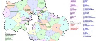
Administrative division
This division is required to ensure management functions and is regulated by a special law of the Moscow Region. To optimize local self-government, a municipal structure is used. The territories of municipalities of the Moscow region have local urban, and not regional (unlike districts) subordination. Their typical size is small.
The region is also divided into larger administrative-territorial units - districts of the Moscow region. Each district is divided into rural and urban settlements. There are also urban districts and cities of regional subordination, as well as closed administrative-territorial entities.
The sizes of districts in the Moscow region are extremely diverse. In general, the system of administrative-territorial division in the region is quite complex and differs in this from that in other regions of the Russian Federation, for example, in the Krasnodar Territory or in the Rostov Region, which are divided into approximately equal in size districts, governed by the heads of administrations of the corresponding districts.
The total number of districts of the Moscow region is 51. The picture of the administrative-territorial division of the Moscow region is further complicated by the presence of a separate entity - the city of Moscow. Its borders are quite chaotic; There are separate island territories, also subordinate to Moscow. The Moscow urban district cuts the region almost in half, leaving only a wide northeastern bridge. Such a chaotic division can hardly be considered appropriate. Rather, it is the result of spontaneous transformations and insufficiently thought-out decisions.
Thus, the territory of Moscow and the Moscow region has a complex, confusing and not entirely rational zoning. And this differs from many other regions of the Russian Federation.
What region is Moscow
Moscow , our capital, is a city so large and significant that it is recognized as an independent region of Russia.
Only three cities in the Russian Federation are separate regions, the second and third are Sevastopol and St. Petersburg. The so-called cities of federal significance.
More than 12 million people live in Moscow - this is not even close to anywhere else in our country. The city is so huge and self-sufficient that residents have long jokingly asked the question “is there life beyond the Moscow Ring Road?”, speaking, of course, about the city’s ring road. Apparently, to clarify this issue a little, the authorities in 2011–12 annexed the outskirts of Moscow, thanks to which the city increased by almost 2.4 times! The area of the capital has never expanded so seriously and quickly before. This raised Moscow to 6th place in the ranking of the largest cities in the world by area , and the Moscow region included a whole list of cities, villages and even farmsteads.
Protected areas of the Moscow region
Some parts of the region are under protection. Thus, in the Serpukhov region there is the Prioksko-Terrasny Biosphere Reserve. The bison and communities of the northernmost steppe formations of the European part of the country are protected there. Another important protected site is the Zavidovo National Park, part of which already belongs to the Tver region. Other protected objects are: the Botanical Garden of Medicinal Plants, a natural monument called “Lake Kiev”, and the Yablokov Arboretum.
In total, there are more than 200 specially protected natural areas in the region. To improve the quality of nature conservation, a regional Red Book has been published since 1998.
Khimki is the closest to Moscow
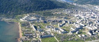
It is a satellite of the capital and ranks third in terms of population near Moscow. Khimki is located on the banks of the Moscow Canal. Several rivers flow through the large area and surrounding area. Forms the Khimki district. The population here is multinational, but Russians predominate. Khimki is constantly growing, being built up, local residents work in factories, energy facilities, and the capital. In 2000, the city IKEA store was opened, which later became part of the MEGA shopping complex.
The only local theater is called “Our House”; in addition, among cultural objects there are two Palaces of Culture, a cinema, and 5 museums. The art gallery is one of the most entertaining attractions. In addition to paintings, there are 500 rare books and 11,000 postcards depicting paintings.
There are many temples in the surrounding, urban areas. Among such buildings, the Church of Alexander Nevsky is noteworthy. The best craftsmen of the Urals worked on the creation of bells. Services are held daily, and a Sunday school for children is open.
A beautiful historical monument, well preserved to this day, is the Bratsevo estate. Today the complex consists of a 14th century manor house and additional buildings from the 19th century. During the Great Patriotic War, the estate was looted, furniture and valuables were lost. After the war, the rooms were used as a kindergarten and a school. Today it is a holiday home. In front of the central entrance there is a fountain, which was reconstructed in 2012. The estate is surrounded by a beautiful green park.
Municipal districts of the Moscow region
In total, there are 36 municipal districts in the Moscow region:
— Volokolamsk with its center in the city of Volokolamsk (index 143600).
- Voskresensky with its center in the city of Voskresensk (index 140200).
— Dmitrovsky with its center in the city of Dmitrov (index 141800).
— Zaraisky with its center in the city of Zaraysk (index 140600).
— Yegoryevsky with its center in the city of Yegoryevsk (index 140300).
— Istra with its center in the city of Istra (index 143500).
— Klinsky with its center in the city of Klin (index 141600).
— Kashirsky with its center in the city of Kashira (index 142903).
- Krasnogorsk with its center in the city of Krasnogorsk (index 143404).
- Kolomensky with its center in the city of Kolomna (index 140407).
- Leninsky with its center in the city of Vidnoye, Leninsky district (index 142700).
— Lukhovitsky with its center in the city of Lukhovitsy (index 140501).
— Lotoshinsky with its center in the city of Lotoshino, Lotoshinsky district (index 143800).
— Lyubertsy with its center in the city of Lyubertsy (index 140000).
— Mytishchi with its center in the city of Mytishchi (index 141008).
— Mozhaisk with its center in the city of Mozhaisk (index 143200).
— Naro-Fominsk with its center in the city of Naro-Fominsk (index 143300).
— Ozersky with its center in the city of Ozyory (index 140560).
— Odintsovo with its center in the city of Odintsovo (index 143000).
— Noginsky with its center in the city of Noginsk (index 142400).
— Podolsky with its center in the city of Podolsk (index 142100).
— Orekhovo-Zuevo with its center in the city of Orekhovo-Zuevo (index 142600).
— Pavlovsky Posad with its center in the city of Pavlovsky Posad (index 142500).
— Pushkinsky with its center in the city of Pushkino (index 141207).
— Ramenskoye with its center in the city of Ramenskoye (index 140100).
— Sergiev Posad with its center in the city of Sergiev Posad (index 141300).
- Ruzsky with its center in the city of Ruza (index 143100).
— Solnechnogorsk with its center in the city of Solnechnogorsk (index 141500).
— Serpukhovsky with its center in the city of Serpukhov (index 142203).
— Serebryano-Prudsky with its center in the city of Serebryanye Prudy, Serebryano-Prudsky district (index 142970).
- Stupinsky with its center in the city of Stupino (index 142800).
- Taldomsky with its center in the city of Taldom (index 141900).
— Shatura with its center in the city of Shatura (index 140700).
- Chekhovsky with its center in the city of Chekhov (index 142300).
— Shakhovsky with its center in the city of Shakhovskaya, Shakhovsky district (index 143700).
— Shchelkovsky with its center in the city of Shchelkovo (index 141100).
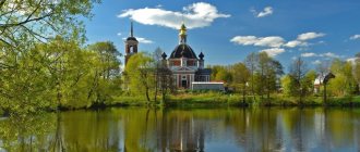
Tourist sites
The Moscow region is rich in attractions. Perhaps you can find much more interesting tourist sites there than in the capital. Here you can not only have a good rest, but also learn a lot of new things. One of the main pearls of the Moscow region is the village of Arkhangelskoye. In the summer, a whole string of residents and guests of the capital flocks here. And not in vain, because in Arkhangelskoye there is a palace and park ensemble, laid out in the likeness of the one in Peterhof. Another interesting tourist attraction in the Moscow region is Pancake Mountain. From the observation deck there is an excellent view of the Trinity-Sergius Lavra.
You can’t help but visit Bolshiye Vyazemy, the poetic birthplace of Pushkin. Many interesting monuments of Russian culture are collected here. One of the most visited tourist sites in Dmitrov is the monastery. This is a place of pilgrimage for many Orthodox Christians. On the territory of the monastery there is the Cathedral of Boris and Gleb, built in the 16th century. Another attraction of the Moscow region is the Gremyachiy Klyuch waterfall. As the ancient legend says, he appeared through the prayer of St. Sergius of Radonezh. There are many more tourist sites located in the Moscow region. By visiting them, you can better understand Russian history and culture. And of course, just relax and enjoy the beauty of the world around you!
Improvement of the territory of the Moscow region
Territory improvement work is focused primarily on improving the condition of the courtyards of multi-storey buildings. For this purpose there is a special law “On improvement in the Moscow region”. When implementing it, methodological recommendations are used for organizing comprehensive landscaping of courtyard areas. This is the responsibility of the administration of the corresponding urban settlement.
The courtyard area is understood as land directly adjacent to apartment buildings and in common use. It may include a playground, parking, waste storage area, green space, lights, posters and other public facilities.
Comprehensive landscaping of the territory means bringing all the components of the territory described above to a standard state.
Activities to provide all these attributes and maintain them in proper condition are carried out annually. The greatest complaints are caused by the insufficient level of lighting in the areas and the dilapidation of children's playgrounds. There are also considerable problems with the condition of the road surface of internal and external roads.
Active work on comprehensive improvement was carried out in 2016. They included asphalting roads and paths, overhauling playgrounds, installing additional play elements, repairing fences, and installing information stands.
Domodedovo is the largest in area in the Moscow region
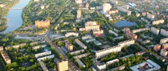
In the southern part of the area is Domodedovo. This is the first on the list, the largest city near Moscow in terms of territory. 127,000 people live here; together with the surrounding area, the population is 172,113. Domodedovo consists of eight microdistricts. In 2012, it was awarded the title of the most attractive in the Moscow region for investing in new buildings. In recent years, it has been actively developing new residential buildings and high-rise buildings to attract the acquisition of real estate. Living conditions here are favorable, the environment is good.
Previously, there was a village of the same name, founded in 1401, but it became an urban district only in 2005. Nearby is Domodedovo International Airport, one of the largest in Eastern Europe.
In terms of economic indicators, it is the leader among all urban settlements near Moscow. Enterprises operate here and sales are developing well. Many city residents work at the airport, where good wages, career growth, and social benefits are provided.
The city's attractions attract visitors. At the location of the central part there is a local history museum, where the history of the region is stored. Exhibitions are regularly held here. There is an aviation museum, and in the surrounding area there are botanical and geological objects:
- Syanovskie caves
- Nikitsky quarries
- Estate "Odintsovo"
At the entrance there is the Khutorok complex, which includes restaurants, a pond, shops, a Chinese-style pagoda, and a museum. This is a great place to relax with the whole family. Opposite is the coniferous park “Yolochki”, where the Church of the Holy Blessed Ones is open. Peter and Fevronia.
Ecological improvement
As part of the general improvement of the territory of the Moscow region, much attention should be paid to environmental measures. For example, such as clearing areas of garbage, cleaning water bodies, improving the condition of the road surface, landscaping residential complexes and public areas, repairing playgrounds, repairing dilapidated and dilapidated housing, and so on.
The obligatory nature of such events is dictated by considerations of quality of life and safety of the population. Thus, according to research by European scientists, the accumulation of plastic household waste in inappropriate places (landfills, ponds, etc.) and the abrasion of car tires by road surfaces leads to increasing pollution of all environments with microscopic particles and fibers of artificial polymers. And if we continue to turn a blind eye to this, then in the future there will be such a number of them that the health of a huge number of the planet’s inhabitants will be jeopardized.
Cultivated area of agricultural crops
Not only industry, but also agriculture is actively developing in the Moscow region. Moreover, both crop farming and livestock farming. The area of the Moscow region that is used in agriculture is about 2 million hectares. The further you go south from the capital, the more. Thus, when considering the area of the Moscow region, you need to understand that half is land allocated for agricultural needs. Previously, during the Soviet era, this figure was even higher. As of 2014, 518.3 thousand hectares are allocated for crop areas. This is more than in 2013. However, it should be noted that this indicator has gradually decreased since the collapse of the USSR.
Most of the sown areas are occupied by fodder crops. Among them, grains and potatoes play a huge role. It is quite interesting to consider such a subject of the Russian Federation as the Moscow region. The area (km2) devoted to agriculture is simply impressive. In 2014, 102.3 thousand hectares were allocated for planting grain and leguminous crops. Livestock farming occupies an important place in the economy of the Moscow region. Mainly meat and milk are produced here.