| district[1] / municipal district[2] | |
| Balashikha district | |
| 55°48′00″ n. w. 37°56′00″ E. d.HGYAO | |
| A country | Russia |
| Entered | Moscow region |
| Included | 13 settlements |
| Adm. center | Balashikha |
| History and geography | |
| Date of formation | 1941 |
| Date of abolition | 2006[3] / 2011[4] |
| Height | 167 m |
| Population | |
| Population | ↗187,988[5] people (2002) |
Balashikha District
is an abolished administrative-territorial unit and former municipal entity of the same name (municipal district) in the Moscow region of Russia.
Existed from 1941 to 2011 (with the exception of 1963 to 1965). In 1929-1941 it was the Reutov district
.
The center of the Balashikha district was the city of Balashikha, while the former regional center, the city of Reutov, was part of the Balashikha district until 1970.
Since 2005, the territory of the former Balashikha district belongs to the Balashikha urban district.
Story
On July 12, 1929, the Reutovsky district
with its center in the working village of Reutovo. The district included the following territories of the former Moscow province:
- from the Razinsky volost of the Moscow district: the working villages of Reutovo and Balashikha; holiday villages Nikolsko-Arkhangelsky and Saltykovka; village councils Abramtsevo, Golyanovsky, Ivanovsky, Izmailovsky, Kaloshinsky, Kuchinsky, Leonovsky, Nikolsko-Arkhangelsky, Nikolsko-Trubetskoy, Pehra-Pokrovsky, Temnikovsky, Feninsky and Shchitnikovsky
- from Vasilyevskaya volost of Bogorodsky district: working village of Savino; holiday villages of Vishnyakovo and Obiralovka; village councils Dyatlovsky, Kopninsky, Novomiletsky, Novsky, Poltevsky, Savvinsky, Sobolikho-Purshevsky and Chernovsky.
Borders of the Reutovsky district for 1939-40 On
May 20, 1930, the Kopninsky s/s was transferred to the Ukhtomsky district.
On January 7, 1934, the Nikolsko-Trubetskoy s/s was abolished.
On May 10, 1935, the workers' villages of Izmailovo, Kaloshino and Kuchino were formed. At the same time, Izmailovsky, Kaloshinsky and Kuchinsky village councils were abolished.
On November 10, 1936, the working village of Izmailovo was included within Moscow.
On December 4, 1938, the holiday village of Obiralovka was transformed into the working village of Zheleznodorozhny.
On May 26, 1939, the working village of Balashikha was transformed into a city of regional subordination. On June 7, the workers' village of Kaloshino was included within Moscow. On August 21, the working village of Reutovo was transformed into a city of regional subordination of Reutov.
On June 20, 1940, the dacha settlement of Vishnyakovo was annexed to the dacha settlement of Nikolsko-Arkhangelskoye.
On May 19, 1941, the district center was moved to Balashikha, and the district was renamed Balashikha District
.
On August 16, 1946, the settlement of Kupavna received the status of a holiday village.
On August 7, 1952, the city of Balashikha received the status of a city of regional subordination and was removed from the district. At the same time, the working village of Zheleznodorozhny was transformed into a city of regional subordination.
On June 14, 1954, Abramtsevo, Dyatlovsky, Leonovsky, Poltevsky, Savvinsky, Sobolikho-Purshevsky, Temnikovsky and Shchitnikovsky s/s were abolished.
On June 3, 1959, the cities of Losino-Petrovsky and Fryazino were annexed to the Balashikha region; working villages of Sverdlovsky, Fryanovo and Chkalovsky; village councils Amerevsky, Aniskinsky, Bulakovsky, Golovinsky, Zhegalovsky, Kablukovsky, Maltsevsky, Medvezhye-Ozersky, Mishnevsky, Nikiforovsky, Novsky, Ogudnevsky, Oseevsky, Ryazantsevsky and Trubinsky from the abolished Shchelkovsky district. On July 31, Amerevsky and Novsky s/s were merged into Grebnevsky s/s, Kablukovsky and Ogudnevsky - into Vorya-Bogorodsky. Mishnevsky and Nikiforovsky s/s were abolished. Bulakovsky s/s was renamed Staropareevsky. On August 8, the working village of Chkalovsky was included in the city of Shchelkovo.
In 1960, the Shchelkovsky district and the city of Zheleznodorozhny were separated from the Balashikha district, which became a city of regional subordination. Part of the Balashikha district went to the city of Moscow (including the Golyanovsky village council (now the Moscow district of Golyanovo); the Ivanovsky village council (now the Moscow district of Ivanovskoye), as well as the reassigned workers' village (settlement) Stalinsky (since 1961 - Vostochny). On the remaining territory of the district the city of Reutov; the holiday villages of Nikolsko-Arkhangelsky and Saltykovka; the village councils of Nikolsko-Arkhangelsky, Pehra-Pokrovsky and Feninsky remained.
On February 1, 1963, the Balashikha district was abolished. The cities and towns that were part of it were transferred to the subordination of the city of Balashikha, and the village councils were transferred to the Mytishchi enlarged rural district.
January 22, 1965 Balashikha district
was restored. It included the city of Reutov, the holiday villages of Nikolsko-Arkhangelsky and Saltykovka; village councils Nikolsko-Arkhangelsky, Novomiletsky, Pehra-Pokrovsky, Feninsky and Chernovsky. The center of the region was the city of regional subordination of Balashikha.
On October 1, 1970, the city of Reutov received the status of a city of regional subordination and was removed from the district.
On February 2, 1982, the Feninsky village council was abolished in favor of Chernovsky. At the same time, the Novsky village council was created.
In accordance with Decree of the President of the RSFSR dated August 22, 1991 No. 75 “On some issues of the activities of the executive branch in the RSFSR,” the executive committee of the Balashikha City Council ceased its activities, and its functions from January 4, 1992 were transferred to the created Administration of the Balashikha District.
On February 3, 1994, village councils were transformed into rural districts[6].
By Decree of the Governor of the Moscow Region of June 10, 2003 No. 128-PG, several settlements: the dacha village of Nikolo-Arkhangelsky, the dacha village of Saltykovka, the village of Nikolsko-Arkhangelskoye, the village of Gorbovo, the village of Nikolsko-Trubetskoye, the village of Pehra-Pokrovskoye, the village of Lukino, the village of Bezmenkovo and the village of Novaya - were included in the city limits of Balashikha. At the same time, the Nikolsko-Arkhangelsk and Novsky rural districts were abolished[7].
By Decree of the Governor of the Moscow Region of October 15, 2003 N 195-PG, the Novomiletsky rural district was abolished in favor of Chernovsky [8].
By Decree of the Governor of the Moscow Region dated August 27, 2004 No. 180-PG, the village named after. On May Day, the village of Shchitnikovo and the village of Abramtsevo. At the same time, the Pehra-Pokrovsky rural district was abolished[9].
By the law of December 29, 2004, the municipal formation “Balashikha District of the Moscow Region” with the status of a municipal district from January 1, 2006 was transformed into the municipal formation of the Balashikha
[10].
By the law of July 14, 2006, the last rural district (Chernovskaya) was excluded from the registration data of administrative-territorial and territorial units of the Moscow region from January 1, 2007 [11].
In 2011, the Balashikha district as an administrative-territorial unit was also abolished, and in its place an administrative-territorial unit was formed - a city of regional subordination with an administrative territory.
Reutov is not yet a ghetto. How does a densely populated city from the Moscow region live?
Ekaterina Torgushina, Ekaterina Kalaeva, July 16, 2022, 20:22 — REGNUM One of the closest cities in the Moscow region to the capital, Reutov has greatly increased in population and development in recent years. According to preliminary estimates by Mosoblstat, as of January 1, 2022, 106,990 people live there permanently on just 8.89 square meters. km of territory. Population density per square meter km in the Moscow region population is about 12 thousand people. This is higher than in New York and Singapore, much higher than in the Russian capital. In Chinese Shanghai, which in this context has become a household name, there are only 3.8 thousand people/sq. km. The only situation worse than in Reutov is in Lyubertsy, where the level is close to 16 thousand (almost Mumbai). At the same time, active development of the Moscow region is only continuing. How this trend could turn out for city residents in the future and how the satellite city of Moscow lives, a REGNUM .
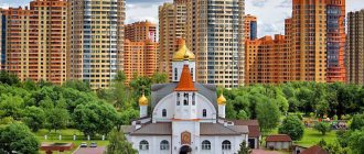
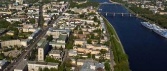
New buildings in Reutov
Ekaterina Kalaeva © IA REGNUM
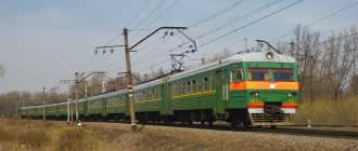
You can get from the capital to the Moscow region by several means of transport: by train, by minibus No. 926K from the Vykhino station and by metro (terminal station Novokosino of the Kalininskaya line). The minibus arrives in the northern part of Reutov, and the metro is located in the southern part - the city is divided by the Gorky direction railway of the Moscow Railway, you can only travel from one part to the other through the Moscow Ring Road. Residents of Reutov like their city, even despite the abundance of new buildings - after all, “Moscow is here, nearby.” “From the Reutovo railway station to Nikolskoye, you could previously see fields and forests from the train window. Now the fields are almost completely built up with high-rise buildings. Moreover, the buildings are very dense, you can even see it from the train window,” one of the users of the Otzovik website shares his observations.A visitor to the city can immediately verify the veracity of his words. However, the northern part, the “old” Reutov, looks more spacious - there high-rise buildings still coexist with low-rise residential buildings, there are buildings of three and four floors, and on Sovetskaya Street and Gagarin Street there are mainly five-story buildings, but high-rise new buildings are also found.
The situation is different in the southern part of the city, the “new” Reutov, - there the territory is built up mainly with residential multi-storey buildings, and low-rise buildings - shops, schools and kindergartens. In appearance, it is a typical residential area with high-rise buildings of nine floors and above. There is also a metro station, shopping centers, a city park and a small alley where there are food stalls.The city, which is small in area, is divided into microdistricts. In one of them, the 10th, residents recorded a video message to President Vladimir Putin asking him to stop the “inhumane development.” The video was published on the Reutovo public page on the VKontakte social network.
“Dear Vladimir Vladimirovich, we are now standing in the courtyard of houses in the 10th microdistrict of the city of Reutov, in which you see absolutely inhumane buildings in the background. Children are forced to walk in the most terrible conditions, there is only dirt, concrete and rubber. There is not a single tree, not a single large bush, not even a single bird. Look, there's nothing. You see a kindergarten, a school and a parking lot that have been unfinished for four years, and in the neighboring yard there is an unfinished hospital. The shortage of kindergartens in the 10th microdistrict of the city of Reutov is 60%,” the video reports.
The text to the video also contains information about the construction of a hotel and sports complex on the site of courtyards with a green zone: “We, the residents of Reutov, appeal to the president: stop this chaos! People have enough shops, people don’t have enough air!”
Student Lisa , who lives near the Reutov city park, believes that there are no problems with infrastructure in the city. She told a REGNUM that living in large high-rise buildings is quite comfortable, there is everything you need nearby - grocery stores, pharmacies, sports clubs. However, she admitted that she does not have enough green areas:
“The park has shrunk three to four times over the past ten years, although it has become neater and more fashionable. There are almost no places where you can retire. The same applies to the area near the pond. Everything is beautiful and well-groomed, but for such a big city there is not enough greenery. There are people everywhere,” the girl said.
Another problem of the city, in her opinion, is gas exhaust from the Kuchinskaya landfill, which can be felt in the air in windy weather. “It’s impossible to open the window,” the girl assures.
Konstantin, who was waiting for transport at a stop in the northern part of the city, told the correspondent IA REGNUM about urban recreation areas. For example, local residents consider the area behind the House of Culture to be a park, although “there is no park, just playgrounds.” In the same part of the city there is the Factory Pond park, but it is also small in area (at least for such a densely populated city).There really aren’t many green areas where you can walk and breathe in Reutov, but in the northern part of the city the vegetation that is planted along the roadways on the streets saves the day. There are also many playgrounds, on one of which Elena :
“I personally really love [the city]. Moscow - here it is, nearby. And here there is greenery, at least you can let the child out. What about Moscow? - the woman thinks. When asked about enrolling her grandson in kindergarten, Elena replies that everything can be decided: “There were lines, but the turn has come. We recorded as always."
The yards are filled with cars
Ekaterina Kalaeva © IA REGNUM
One of the city's biggest visible problems is the lack of parking spaces. The courtyards and roadsides in Reutov are completely filled with vehicles. Varvara , who often comes here to visit friends, shared her experience with the correspondent:
“There’s nowhere to park. Entering the courtyards is not an option at all. I park along some street, and drive around in circles, waiting for some car to pull out, and only then immediately stand in its place. This is the only way, and at any time of the day: in the morning, in the afternoon, in the evening. It’s impossible to park at all in the evening,” the girl said.
She also said that the exit from the Moscow Ring Road “is always stopped” because “there is a very short traffic light there, and there are a lot of cars.” But there are practically no traffic jams in the city itself.
A local resident standing at the bus stop complained that the discounted fare on Reutov’s minibuses was not valid: “There is a card for a pensioner near Moscow. But the minibus doesn’t pay, that’s another matter.” In general, according to her observations, public transport runs quite often.
In Reutov, residents said, there is no maternity hospital. An important transport problem is transport links between two parts of the city, which, as already mentioned, requires access to the Moscow Ring Road. However, this connection cannot be avoided - on the south side, for example, there is no emergency room or police department.
Despite all the problems, life in Reutov looks quite prosperous, and there are no obvious signs of marginalization or transformation into a ghetto. However, it is clear that active and dense development has changed the city. There are already not enough places for cars here, and there is a shortage of fresh air and space. It is difficult for residents to fulfill their leisure needs, and to solve many issues they go to Moscow. There is no doubt that these problems will become even more acute in the future.
Settlements
From 1929 to 1970 the area included Reutov. From 1952 to 1992 Balashikha was not part of the district, being a city of regional subordination. In 1959-1960 the district temporarily included the territory of the Shchelkovsky district, again restored in 1960 (thus, the cities of Losino-Petrovsky and Fryazino, as well as the towns of Sverdlovsky and Fryanovo, Kuchino and Savvino left the Balashikha district [17]); At the same time, the city of Zheleznodorozhny[17] was removed from the Balashikha district (became a city of regional subordination). In 1970, the city of Reutov[17] left the district (became a city of regional subordination).
In 1970-2003. The external boundaries of the district did not change. The internal composition also did not undergo major changes, with the exception of the abolition of the Feninsky village council and the formation of Novsky in 1982, the return of Balashikha to the district in 1992 (became a city of district subordination), and the renaming of village councils into rural districts in 1994.
As of 2002, the Balashikha district included the city of regional subordination of Balashikha, 2 urban-type villages (dacha villages) Nikolsko-Arkhangelsky and Saltykovka, as well as 5 rural districts: Nikolsko-Arkhangelsky, Novomiletsky, Novsky, Pehra-Pokrovsky and Chernovskoy.
| Administrative-territorial unit | Population (persons) 2002[5] | Locality | Population np (persons) 2002[5] |
| city of regional subordination Balashikha | 147909 | Balashikha | 147909 |
| urban-type settlement Nikolsko-Arkhangelsky | 18637 | urban-type settlement Nikolsko-Arkhangelsky | 18637 |
| urban-type settlement Saltykovka | 4611 | urban village Saltykovka | 4611 |
| Nikolsko-Arkhangelsk rural district | 462 | village of Nikolsko-Arkhangelskoye | 462 |
| Novomiletsky rural district | 3197 | village of New Milet | 670 |
| Sobolikha village | 228 | ||
| village of Rusavkino-Romanovo | 82 | ||
| village of Rusavkino-Popovshchino | 54 | ||
| village of Purshevo | 2163 | ||
| Pehra-Pokrovsky rural district | 5391 | Pehra-Pokrovskoe village | 442 |
| Lukino village | 183 | ||
| Gorbovo village | 59 | ||
| Nikolsko-Trubetskoye village | 387 | ||
| village of Shchitnikovo | 479 | ||
| Abramtsevo village | 767 | ||
| State Farm village named after 1st of May | 3074 | ||
| Novsky rural district | 1112 | Novaya village | 855 |
| Bezmenkovo village | 257 | ||
| Chernovsky rural district | 6669 | Chernoe village | 5803 |
| Fedurnovo village | 231 | ||
| Poltevo village | 136 | ||
| Pestovo village | 97 | ||
| Fenino village | 157 | ||
| Pavlino village | 66 | ||
| Dyatlovka village | 179 |
In 2003-2004 2 urban-type settlements (dacha villages) Nikolsko-Arkhangelsky and Saltykovka, all rural settlements of the Nikolsko-Arkhangelsk, Novsky and Pehra-Pokrovsky rural districts were included in the city limits of the city of Balashikha, and the Novomiletsky rural district was merged into the Chernovsky rural district.
As of December 2004, the Balashikha district included the city of regional subordination of Balashikha and the Chernovsky rural district, which consisted of 12 rural settlements[10]:
| № | Locality | Type of settlement | Population (persons) 2002 |
| 1 | Balashikha | city, administrative center | ↗147 909[5] |
| 2 | Dyatlovka | village | ↘179[18] |
| 3 | New Miletus | village | ↗670[18] |
| 4 | Pavlino | village | ↘66[18] |
| 5 | Pestovo | village | ↗97[18] |
| 6 | Poltevo | village | ↘136[18] |
| 7 | Purshevo | village | ↗2163[18] |
| 8 | Rusavkino-Popovschino | village | ↘54[18] |
| 9 | Rusavkino-Romanovo | village | ↘82[18] |
| 10 | Sable | village | ↘228[18] |
| 11 | Fedurnovo | village | ↘231[18] |
| 12 | Fenino | village | ↘157[18] |
| 13 | Black | village | ↗5803[18] |
Reutov on the map of Russia, geography, nature and climate
The city is located in the Meshchera Lowland. There is only one large body of water in Reutov - Factory Pond. Since the water in it does not meet sanitary and hygienic requirements, the facility is used only for a recreation area, but not for swimming. The Chechera River flows on the border with Balashikha.
The city of Reutov is located in a zone of temperate continental climate, characterized by cold winters and hot summers. In the winter months, the average temperature is minus 10 degrees, in the summer months – plus 18-22 degrees.
Routes on the map of Reutov. Transport connection
If you look at the map of Reutov from a satellite, you can see how the city is divided into two parts by the Gorky direction of the Moscow Railway. Passengers board and disembark at the Reutovo station and the Stroika platform of the Balashikha line.
As for internal transport, buses, trolleybuses and minibuses travel around the city. Thus, residents have access to 15 bus, 16 route and 2 trolleybus routes.
A distinctive feature of Reutov is its own Novokosino metro station, opened on August 30, 2012. There are plans to build another one in the future.
Why was this question raised:
No matter how the city is, there are problems in it. If you need to get to the MFC or the city administration, you need to go through Moscow, because all government organizations are constantly overcrowded and they cannot cope with so many requests. For example, the clinic cannot cope with the current load. Groundwater in the city is very high, which is why many underground parking lots are flooded. The houses cannot stand it and are falling apart, there is no fire alarm in the houses, the freight elevators are inoperable.
Also, infrastructure is an important problem. There is no room for new developments in the city, however, the authorities are constantly pushing for construction permits, because of this the houses are too close to each other, which is very worrying for citizens. Most of the residents of Reutov work in Moscow and pay taxes to the “treasury” of Moscow, and because of this, Reutov’s budget is almost empty and cannot fully finance the construction of new houses, which is problematic and the budget of the Moscow region has to be squandered. In addition to all that has been said, residents are unhappy that the Northern and Southern parts are “torn apart” due to the railway tracks.
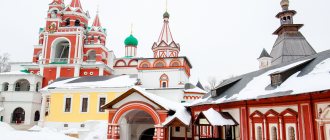
Sights of the city of Reutov
Reutov is not a very large city, the main monuments of which are located on Pobeda Street. These include:
- Monument to the bell (intersection of Lenin and Victory streets);
- Memorial complex Eternal Flame (Victory Street);
- Museum of History and Local Lore (Pobedy St., 2);
- Museum and Exhibition Center (Pobedy St., 2);
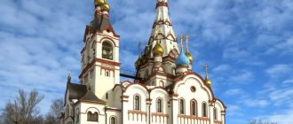
- Church of the Holy Trinity (Pobeda St., 3);
- Chapel of St. George the Victorious (Victory St., 11).
Other attractions of the town:
- Children's Musical Opera Theater (Yuzhnaya St., 17);
- multifunctional stadium "Start" (Novaya St., 1a);
- House of Worship;
- Museum of the History of the Reutov Manufactory (Lenin St., 14);
- monument to academician Chelomey V.N. (Sovetskaya St., 4);
- Reutov City Park and the “Middle Park” fountain (Oktyabrya St., 20);
- metro station "Novokosino".
- Temple of the Kazan Icon of the Mother of God (October St., 14);
Origin of the city:
We can talk for a very long time about the origin of this city, because there are several theories of origin:
- One of these theories says that mourners of exiles who, in turn, were exiled to Siberia, stopped near the Vladimirsky Highway.
- The second is connected with the Moldavian river “Reut”; they said that on the territory of the now existing city of “Reutov”, Moldavian traders who lived near the river “Reut” came.
- The third is associated with the large number of howler bears, of which there were a lot in these territories.
- And fourth, which is generally accepted, in these territories there was a signal line of Moscow’s defense, consisting of watchtowers with bells, which, in turn, were called “Reuts”, their purpose was to transmit a signal that the enemy was approaching Moscow.
One of these famous towers was located at the highest point of the city - 166 meters above the sea. The towers were called so because a large signal bell hung on them, which in the Old Church Slavonic language meant “Reut”.
On this tower stood a clerk (state employee), a person who was responsible for the service of the sentinels. And from the name of the tower, these clerks were renamed as “Reut”.
In memory of this tower, a monument and a bell were erected and in honor of the above, the bell is depicted on the coat of arms of the city.