See location on the map
Located in the Volga-Vyatka region in the eastern part of the East European Plain, Mari El occupies an area of 23.38 thousand km2. The satellite map shows that the borders of the republic touch:
- in the north and northeast with the Kirov region,
- in the southeast with the Republic of Tatarstan.
- in the south - with the Chuvash Republic.
- in the west - with the Nizhny Novgorod region.
The specificity of the territory occupied by Mari El is that its length from west to east is 225 km, and from north to south – 150 km. The total length of the borders exceeds 1200 km.
Relief
The relief map of the Republic of Mari El looks in such a way that it can be conditionally divided into three parts:
- Western and central . They are represented by the Mari Lowland, which is part of the Vetluzhsko-Unzhinskaya province and occupies 49.9% of the territory of the republic.
- Northeastern . Mari-Vyatsky Uval, located on 46% of the area of Mari El and being part of the Vyatka-Kama geographical province.
- The northern part is part of the Volga erosion upland, occupying 4% of the republic’s area.
The highest relief height, located on the Mariysko-Vyatsky ridge, reaches 275 m above sea level .
Hydrology
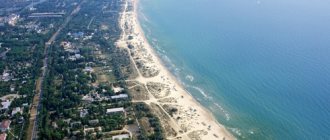
It is clearly visible on the map that the water resources of Mari El, occupying 3.7% of the territory, are represented by:
- 476 rivers and streams, with a total length of over 7 thousand km.
- 689 lakes, a water surface of 2.5 thousand hectares.
- 181 ponds and reservoirs, the volume of which is 97.6 million m3.
- section of the Kuibyshev reservoir, with an area of 7.8 thousand hectares.
- section of the Cheboksary reservoir – 60 thousand hectares.
- swamps and wetlands - 208.3 thousand hectares.
A watershed with an area of 19.1 thousand km2 flows through 14 river basins into the Volga; from 4.2 thousand km2 across 5 basins - to Vyatka (region of the north-east of the republic).
Lakes, with a total area of almost 200 km2 and located in river floodplains, on watersheds and in channels, are divided into karst, interdune and floodplain. The record holders are: Lake Yalchik, which occupies 150 hectares of water surface, and Lake Tabashinskoye, which is 55 meters deep.
Lands and territories
The Republican Land Fund includes:
- Forest lands occupying 54.6% of the area of this subject of the Federation.
- Agricultural land in 32.9% of the territory of Mari El.
- Land occupied by settlements, industrial organizations and special-purpose facilities – 9.4%.
- Water Fund – 2.9%.
- Reserve – 0.2%.
The main part of the territory of Mari El is a zone of mixed and coniferous forests of the southern taiga, and only in the southern regions of the right bank of the Volga do broad-leaved tree species grow.
Climate
The republic has a temperate continental climate, formed under the influence of air currents from the Arctic and Atlantic. Winter is long, cold and snowy; Hot summer.
Mid-July marks the warmest time of the year. The autumn season is cold, windy and wet, often accompanied by early frosts and snow. Winter often begins in November and lasts until mid or late March. Alternating with different lengthy thaws. Spring is dry and cool.
Average temperatures:
- summer +16…+200 C.
- winters -10…-140 C.
- during the year: eastern regions +2.10 C; southwestern regions +3.30 C.
The climatic maximum temperature is +380 C, the minimum is -480 C.
History[ | ]
Mari Autonomous Okrug[ | ]
On November 4, 1920, the Decree on the formation of an autonomous region of the Mari people within Soviet Russia was adopted, which defined the territory and borders of the region. It included Kozmodemyansky and Krasnokokshaysky districts, parts of Cheboksary and Kazan districts of the Kazan province, parts of Urzhumsky and Yaransky districts of the Vyatka province and part of the Vasilsursky district of the Nizhny Novgorod province. The Mari Autonomous Okrug was divided into 3 cantons: Krasnokokshaysky, Kozmodemyansky and Sernursky.
In the 1920s, the territory was gradually formalized. In 1924, the left bank part of the Cheboksary district and lower Povetluzhye were transferred to the MAO, where new Zvenigovsky and Yurinsky cantons were formed, respectively. Morkinsky, Orsha, Toryalsky and Mari-Turek cantons were separated from the Krasnokokshaysky and Sernursky cantons. Thus the number of cantons increased to nine. Volosts were abolished and village councils were enlarged. There were changes in the borders with the Vyatka province and the Tatar Autonomous Soviet Socialist Republic. At this time, the borders were stabilized, and since then they have changed slightly.
In 1929, the Mari Autonomous Region became part of the Nizhny Novgorod Territory (renamed the Gorky Territory in 1932). In the same year, the Krasnokokshaysky canton was renamed Yoshkar-Olinsky.
On April 30, 1931, the Tatar region was formed. On December 10, 1931, the Kozmodemyansky and Yurinsky cantons were united into the Gornomariysky district.
In 1932, all cantons were renamed districts. On July 8, the Tatar district began to be called Paranginsky.
In 1934, the Kosolapovsky district was formed.
On January 25, 1935, Kuzhenersky and Ronginsky districts were formed. In the same year, Toryalsky district was renamed Novotoryalsky.
In 1936, Pektubaevsky and Sotnursky districts were formed. The Gornomariysky district was disaggregated into Elasovsky, Yurinsky and Kozmodemyansky districts. On December 5, 1936, the Gorky Territory was abolished, and the Mari Autonomous Soviet Socialist Republic was formed.
Mari ASSR[ | ]
On August 26, 1939, Lopatinsky (since 1940 - Volzhsky) and Kilemarsky districts were formed.
On December 6, 1943, the Kazan, Medvedevsky and Khlebnikovsky districts were formed.
On February 14, 1946, the Yoshkar-Olinsky district was transformed into the Semyonovsky district.
On January 6, 1956, the Sotnur district was abolished.
On March 11, 1959, Elasovsky, Kazansky, Kosolapovsky, Kuzhenersky, Pektubaevsky, Semyonovsky and Khlebnikovsky districts were abolished.
On February 23, 1960, the Ronginsky district was renamed Sovetsky.
On February 1, 1963, instead of the existing districts, Gornomariysky, Zvenigovsky, Mari-Tureksky, Medvedevsky, Morkinsky, Sernursky and Sovetsky rural districts, as well as the Zvenigovsky industrial district, were formed.
On March 4, 1964, the Novotoryalsky rural district was re-formed.
On January 12, 1965, the rural and industrial zoning system was abolished and the old system returned. At the same time, the Volzhsky, Kuzhenersky and Paranginsky districts were formed.
On December 30, 1966, the Kilemarsky district was formed
On March 31, 1972, the Yurinsky district was formed.
On October 22, 1990, the Mari ASSR was transformed into the Mari SSR.
Mari El[ | ]
On July 8, 1992, the Mari SSR was transformed into the Republic of Mari El[7].
Currently, the ATD of the Republic of Mari El has the following form:
| Urban districts and districts | Center | Rural and urban settlements |
| Urban district "City of Yoshkar-Ola" | Yoshkar-Ola city | |
| Urban district city of Volzhsk | Volzhsk city | |
| Urban district city of Kozmodemyansk | Kozmodemyansk city | |
| Volzhsky district | Volzhsk city | Privolzhsky, Bolsheparatsky, Karamaskoye, Obshiyarskoye, Petyalskoye, Pomarskoye, Sotnurskoye, Emekovskoye |
| Gornomariysky district | Kozmodemyansk city | Vilovatovskoe, Elasovskoe, Emeshevskoe, Krasnovolzhskoe, Kuznetsovskoe, Mikryakovskoe, Ozerkinskoe, Paigusovskoe, Troitskoposadskoe, Usolinskoe |
| Zvenigovsky district | Zvenigovo city | Zvenigovo, Krasnogorsky, Suslonger, Ismenetskoye, Kokshamarskoye, Kokshaiskoye, Krasnoyarskoye, Kuzhmarskoye, Chernoozerskoye, Shelangerskoye |
| Kilemarsky district | village Kilemary | Kilemary, Ardinskoye, Bolshekibeevskoye, Vizimyarskoye, Krasnomostovskoye, Kumyinskoye, Nezhnurskoye, Shirokundyskoye, Yuksarskoye |
| Kuzhenersky district | village Kuzhener | Kuzhener, Ishtymbalskoye, Russko-Shoyskoye, Saltakyalskoye, Toktaybelyakskoye, Tumyumuchashskoye, Shorsolinskoye, Shudumarskoye, Yuledurskoye |
| Medvedevsky district | village Medvedevo | Krasnooktyabrskoe, Medvedevo, Azanovskoe, Azyakovskoe, Ezhovskoe, Znamenskoe, Kuznetsovskoe, Kundysskoe, Kuyarskoe, Lyulpanskoe, Nurminskoe, Pekshiksolinskoe, Russko-Kukmorskoe, Ruemskoe, Senkinskoe, Sidorovskoe, Shoibulakskoe |
| Morkinsky district | village Morkie | Morki, Zelenogorskoe, Korkatovskoe, Krasnosteklovarskskoe, Oktyabrskoe, Sebeusadskoe, Semisolinskoe, Shalinskoe, Shinshinskoe, Shorunzhinskoe |
| Novotoryalsky district | village New Toryal | New Toryal, Maskanurskoye, Pektubaevskoye, Starotoryalskoye, Chuksolinskoye |
| Orsha district | village Orshanka | Orshanka, Wielkopolskoe, Markovskoe, Shulkinskoe |
| Paranginsky district | village Paranga | Paranga, Alashaiskoye, Yeleevskoye, Iletskoye, Ilpanurskoye, Kurakinskoye, Portyanurskoye, Russko-Lyazhmarinskoye, Usolinskoye |
| Sernursky district | village Sernur | Sernur, Verkhnekugenerskoe, Dubnikovskoe, Zashizhemskoe, Kazanskoe, Kuknurskoe, Marisolinskoe, Serdezhskoe, Chendemerovskoe |
| Sovetsky district | village Soviet | Sovetsky, Alekseevskoye, Verkh-Ushnurskoye, Vyatskoye, Kuzhmarinskoye, Mikhailovskoye, Ronginskoye, Solnechnoye |
| Yurinsky district | village Yurino | Yurino, Bykovskoye, Vasilyevskoye, Kozikovskoye, Maryinskoye, Yurkinskoye |
Administrative division of Mari El
The map clearly shows that within the republic there are:
- 3 cities of republican significance - Yoshkar-Ola, Volzhsk, Kozmodemyansk.
- 1 city of regional significance – Zvenigovo.
- 15 urban-type settlements.
- 1597 rural settlements (according to 2010 data) - villages, hamlets, hamlets, settlements.
In addition to populated areas, the territory of Mari El includes 14 districts and 105 rural districts. Local self-government is carried out by 138 municipalities.
Districts and cities of republican significance (urban districts)[ | ]
| № | Russian name | Mari name | Flag | Coat of arms | Administrative center | Area, km²[6] | Population, people[5] (2021) | Population density, people/km² | OKATO | OKTMO |
| 1e-06 | Districts (municipal areas) | |||||||||
| 1 | Volzhsky | meadow moth. Yulser kundem | Volzhsk city | 913,86 | ↘21 188[5] | 23,19 | 88 204 | 88 604 | ||
| 2 | Gornomarisky | mining Kyryk mary kymdem | Kozmodemyansk city | 1971,47 | ↘20 476[5] | 10,39 | 88 208 | 88 608 | ||
| 3 | Zvenigovsky | meadow moth. Provoy kundem | Zvenigovo city | 2748,78 | ↘39 920[5] | 14,52 | 88 212 | 88 612 | ||
| 4 | Kilemarsky | meadow moth. Kilemar kundem gornomar. Kӹlemar kymdem | urban-type settlement Kilemary | 3098,89 | ↘11 626[5] | 3,75 | 88 216 | 88 616 | ||
| 5 | Kuzhenersky | meadow moth. Kuzheger kundem | urban-type settlement Kuzhener | 852,83 | ↘12 214[5] | 14,32 | 88 220 | 88 620 | ||
| 6 | Mari-Tureksky | meadow moth. Mari Turek kundem | town of Mari-Turek | 1513,86 | ↘18 242[5] | 12,05 | 88 224 | 88 624 | ||
| 7 | Medvedevsky | meadow moth. Medvedevo kundem | village Medvedevo | 2791,18 | ↘67 519[5] | 24,19 | 88 228 | 88 628 | ||
| 8 | Morkinsky | meadow moth. Morko kundem | village Morki | 2270,08 | ↘26 930[5] | 11,86 | 88 232 | 88 632 | ||
| 9 | Novotoryalsky | meadow moth. U Toryal kundem | urban-type settlement New Toryal | 920,09 | ↘13 980[5] | 15,19 | 88 236 | 88 636 | ||
| 10 | Orshansky | meadow moth. Orshanke kundem | Orshanka village | 896,49 | ↘12 909[5] | 14,4 | 88 240 | 88 640 | ||
| 11 | Paranginsky | meadow moth. Paranga kundem | Paranga village | 791,66 | ↘13 646[5] | 17,24 | 88 244 | 88 644 | ||
| 12 | Sernursky | meadow moth. Shernur kundem | town Sernur | 1032,08 | ↘22 697[5] | 21,99 | 88 248 | 88 648 | ||
| 13 | Soviet | meadow moth. Soviet kundem | Sovetsky village | 1392,45 | ↘27 846[5] | 20 | 88 252 | 88 652 | ||
| 14 | Yurinsky | meadow moth. Yurino kundem, gornomar. Yurnӹ kymdem | urban village Yurino | 2040,15 | ↘6590[5] | 3,23 | 88 256 | 88 656 | ||
| 14.000002 | Cities of republican significance (urban districts) | |||||||||
| 15 | Yoshkar-Ola | meadow moth. Yoshkar-Ola | Yoshkar-Ola city | 100,39 | ↗286 876[5] | 2858 | 88 401 | 88 701 | ||
| 16 | Volzhsk | meadow moth. Yulser-Ola | Volzhsk city | 39,47 | ↘52 703[5] | 1335,27 | 88 405 | 88 705 | ||
| 17 | Kozmodemyansk | mining Tsikmo | Kozmodemyansk city | 13,41 | ↘19 970[5] | 1489,19 | 88 405 | 88 705 |
Roads of the Republic of Mari El
- Federal highway A295. Yoshkar-Ola – Kazan (Tatarstan);
- P173. Yoshkar-Ola – Kozmodemyansk;
- Federal highway P176. Cheboksary – Syktyvkar (“Vyatka”);
- P172. Yoshkar-Ola - Urzhum.
There are other roads in the region. You can see the federal airport on the online map. It is located ten kilometers from the center of Yoshkar-Ola. There is also a railway station in this city. But the republic also has two bus stations, four ports, 14 railway stations, a river port, and 51 bus stations.