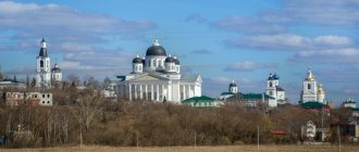
Zhigulevsk is one of the cities of the Volga region and Samara region. It is located on the Zhiguli Mountains on the right bank of the Volga - in its middle reaches. The city was founded in 1949. Zhigulevsk is located 96 km northwest of Samara and 969 km southeast of Moscow.
The area of the city is 60.8 km2. The population of Zhigulevsk is 54,343 people. Time in the city of Zhigulevsk is one hour ahead of Moscow.
City `s history
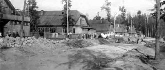
Since the seventeenth century, on the site of present-day Zhigulevsk there were the villages of Morkvashi and Otvazhnoe. The city was built during the Soviet era, and the builders were prisoners. Oil production began, a hydroelectric power station, a cement plant and three limestone quarries were built.
Thanks to the boxing school built in the city, local athletes managed to become winners of world championships and Olympics.
In the eighties, the Samarskaya Luka National Park was formed in the vicinity of Zhigulevsk. In 2006, the Zhigulevsky Nature Reserve became a reserve.
Sights of the city of Zhigulevsk
- “ Samarskaya Luka ” is a national park that includes natural attractions:
- Molodetsky Kurgan is one of the peaks of the Zhiguli Mountains. The height is more than 240 m. The panorama of the Zhiguli Sea is clearly visible from the top.
- Mount Camel and its abandoned limestone mines are attractive to climbers.
- The Stone Bowl is a stone cauldron containing the Nikolsky spring with holy water.
- The exhibition of the A. Shiryaevets Museum in Shiryaev is dedicated to the work of the Samara “peasant” poet who lived at the beginning of the 20th century.
- I.E. Repin Museum is the artist’s house in the village of Shiryaevo. The exhibition includes household items and paintings.
- The Church of the Icon of Our Lady of Vladimir is a functioning wooden church. Erected at the end of the 20th century.
- The Museum of Ufology is an unusual museum in the village of Zhiguli, introducing visitors to anomalous phenomena.
Transport and industry
The city has enterprises in the food, pharmaceutical, military, mining and electric power industries. Previously, there was also an oil-extracting industry, which was practically curtailed due to the depletion of oil reserves. In the energy sector, there is the Zhigulevskaya hydroelectric power station.
The city is crossed by the Ural federal highway. There is a city bus station - buses depart from there to Ulyanovsk, Penza, Samara, Kuznetsk, Dimitrovgrad, Syzran.
Embankment of Zhigulevsk
Not long ago, the improvement of the embankment was completed
. I am pleased to note that the space turned out to be modern, comfortable and pleasant for relaxation.
Benches, trash cans, and art objects were installed here.
There is a large children's playground, a city beach and an observation deck.
The Zhigulevsk embankment is beautiful even in cloudy weather, photo from personal archive
On Zhigulevskaya embankment, many tourists feel like they are in a fairy tale:
go left - Mount Mogutova
go to the right - Bald Mountain and Sokol cliff
Everything is within walking distance. Visiting natural attractions is free.
Population of the city of Zhigulevsk
In 2022, the number of residents of the city of Zhigulevsk was 54,343 people. Since 1959, when systematic data became available, the population has not shown any directional dynamics. Moreover, in the nineties it grew, which is not typical for Russian cities.
Since 2005, the population of Zhigulevsk has remained virtually unchanged. The largest number of residents was in 2008, when the city's population was 57,100 people. A noticeable decrease occurred from 2016 to 2022. The number of residents of Zhigulevsk is greatly influenced by migration.
In 2022, Zhigulevsk was in 304th place among the cities of the Russian Federation in terms of population. The predominance of older age groups is typical, and over time it only increases.
The population density is 894 people per km2. Information on the population is provided by the Rosstat service and EMISS.
Residents of the city are called Zhiguli residents.
Zhigulevsk
The first settlements on the territory of modern Zhigulevsk appeared in the 10th century. The city arose on the land on which the villages of Morkvashi and Otvazhnoe were located. The village of Otvazhnoe had to be moved due to the construction of the Kuibyshev hydroelectric power station. The settlement fell into a flood zone. Between the villages of Shiryaevo and Podgory, the Serny town was built by order of Peter I in 1720. Not far from these places, sulfur was mined, which was supposed to be processed in Sulfur Town. Sulfur was needed for military needs. In the second half of the 19th century, tar and asphalt plants operated near the village of Bakhilova Polyana. The asphalt produced here was considered the best in Europe. In addition, it was cheaper in price. In 1859, in the vicinity of the village of Shiryaev Buerak, a quarry appeared, engaged in the extraction and roasting of limestone. Initially, the quarry belonged to Prince Volkonsky, then it passed to a Samara merchant named Nazarov. After changing several more owners, the quarry finally went to the rich peasant Vanyushin in 1900. The limestone mined in local quarries was considered one of the highest quality in the country. Local limestone was used in the construction of houses in Balakov, Samara and Saratov. The quality of the building material was noted in 1905 and 1906 at exhibitions in the Belgian city of Liege.
The mill industry also developed in the village of Otvazhnoe. The first mill was built in 1880. At the end of the 19th century, Count Orlov-Davydov settled in Bakhilova Polyana. On his order, a narrow-gauge railway was built to transport timber from the most remote corners of the forest. Wood was considered an important strategic and technological raw material.
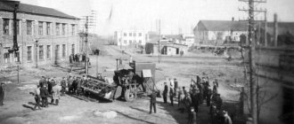
In the 30s of the twentieth century, not far from modern Zhigulevsk, geologists were looking for oil. The search turned out to be successful, despite the fact that it took more than one year to search. At the end of 1937, the first well was found in Yablonevoy Ravine. The search for oil and the development of new wells did not stop even during the Great Patriotic War. A huge number of specialists arrived to develop new wells. This is how the working settlement of Zhigulevsk appeared. At the end of February 1952, the workers' settlement received city status. The city (and previously the village) received its name from the Zhiguli Mountains, otherwise called Zhiguli. The Zhiguli Mountains are considered a historical place. The freemen of Razin and Pugachev were located in these mountains. History reminds itself in the names of geographical objects: Molodetsky Kurgan, Vorovskoy Ravine, Sheludyak Cliff.
The construction of the city and the construction of cement production were organized with the participation of the NKVD forces. Correctional camps were located in the vicinity of the city. After construction was completed they were disbanded. A lot of material was required for construction, so the management decided to establish 3 limestone quarries for the extraction of Zhiguli rocks. Mining was carried out using the open-pit method, which is still used to this day, which causes considerable harm to nature. In the 80s of the twentieth century, the State National Park was founded, called “Samarskaya Luka”. Reclaimed parts of quarries come under the jurisdiction of this park. In 2006, the park and some other nearby areas were declared a biological reserve by UNESCO.
At the beginning of the twentieth century, Morkvashi was a fairly large village. There were at least 125 households here. The city itself had about five thousand houses. The first city development project was developed in 1961 at the Leningrad Institute Lengorproekt. In the early 90s, a new plan was created, which was supposed to be implemented within thirty years. In 1995, a new concept for the city's development was developed. According to this concept, Zhigulevsk should develop in two main directions. First of all, the city should become a center of eco-tourism in its region. The infrastructure of Zhigulevsk must meet international standards. Secondly, Zhigulevsk should receive the status of an industrial center. To achieve this, it is not enough to simply build a huge number of factories in the city and its environs. It is important to equip enterprises with high-tech equipment and take care of environmental safety.
In 2006, a municipal formation appeared, called the Zhigulevsk urban district. The district included Zhigulevsk itself, as well as the largest settlements in this area - the villages of Zolnoye, Bogatyr, Solnechnaya Polyana, Bakhilova Polyana and Shiryaevo. In addition, the microdistrict (former urban-type settlement) Yablonevyi Ovrag became part of the city. The territory of the district is something similar to an archipelago, as the local residents themselves say. The municipality stretches for 60 kilometers along the banks of the Volga.
The city of Zhigulevsk became widely known in Europe thanks to Adam Olearius, a German traveler who visited the city. Olearius described his travel report in his book. Russians also wrote about the city: S. Skitalets, M. Gorky and others. In their books they described not only real historical facts from the history of the city, but also numerous folk legends and tales.
The development of modern Zhigulevsk is determined by the availability of mineral, raw materials and fuel and energy resources. The central place in the Volga-Kama cascade is occupied by the Volzhskaya HPP named after V.I. Lenin. Oil production has been carried out in the vicinity of Zhigulevsk for more than half a century. The Zhiguli Mountains are considered a unique open-air museum-reserve. The city has not only industrial, but also tourism prospects. Over the past 20 years, Zhigulevsk has changed significantly. Many new enterprises were built here. The products of the Uslada confectionery plant are known far beyond the borders of the district. Among the city's popular products one can also name the famous Zhiguli beer. Construction companies, the service sector and enterprises producing medicines are successfully developing.
Molodetsky Kurgan
For lovers of mountain air, a holiday on Molodetsky Kurgan, which is located 25 kilometers from Zhigulevsk, is perfect.
You can get here by car or by public transport - this is more difficult.
Please note: Chernobyl is burning, latest photos and news from the scene, the Ministry of Emergency Situations is losing control, 2022.
The only route - No. 330 - runs from Zhigulevsk to the village of Zhiguley, and from there you can walk to Molodetsky Kurgan. The path is about 7-8 kilometers. At the foot of the Molodetsky Kurgan, photo from personal archive
Molodetsky Kurgan is wonderful at any time of the year: in summer you can swim in the Zhiguli Sea, in winter you can go fishing.
A walk in the forest is always relevant. The main thing is that at any time of the year there is a sense of spaciousness and stunning views!
Zhigulevskoe Sea
Of course, the Zhiguli Sea is just a name.
In fact, during the Soviet years, during the construction of a hydroelectric power station on the Volga, a reservoir was formed. Today the Kuibyshev Reservoir is the largest in Eurasia. It is this that in the Volga region, and even in Russia, that is called the Zhiguli Sea.
Zhigulevskoe Sea, photo from personal archive
The history of the Zhiguli Sea and the construction of a hydroelectric power station changed not only the local climate, but also the architecture of the surrounding cities. In the 50s of the last century, several settlements went under water.
Today, on one side of the Zhigulevsky Sea is the city of Tolyatti, on the other side - the city of Zhigulevsk.
You can relax on the Zhiguli Sea at any time of the year!
In summer it’s like in Crimea, and in winter it’s like on Lake Baikal!
#travel #sea #mountains #tourism #hiking #sights
More interesting articles here: Tourism.
Source of the article: Zhigulevsk: a young city in which “you feel like you’re in Crimea” - the most stunning places, sea and mountains.
- Previous: Zemun market - the place where everything is
- Next: Comfortable and enjoyable holiday at the height of the velvet season in Turkey and Egypt
Museum "Samarskaya Luka"
Today there are three museums in Zhigulevsk, each of them is interesting in its own way.
· Museum "Zhigulevskaya Mosaic" - st. Hydrobuilders 10
· Fox House Museum – st. Tkacheva, 109B
· Museum "Samarskaya Luka" - st. Komsomolskaya, 28
Samara Luka Museum, photo from personal archive
Most of all I liked the exhibitions of the Samarskaya Luka Museum of History and Local Lore.
.
There are three of them in total: “Zhigulevsk”, “Heritage” and “Nature of Zhiguli”
. An experienced guide will tell you about the creation of the city of Zhigulevsk, the construction of a hydroelectric power station, the features of the Samarskaya Luka natural-historical complex, and also share local traditions and legends with tourists.