Geographical position
The area where Primorye is located is located in the southeastern part of the Pacific coast of the Russian Federation. The functions of a regional city are performed by Vladivostok, with a population of half a million, an important political center and the main city of the Primorsky Territory of the Far Eastern District.
The facility’s proximity to China, North Korea (DPRK) and the Khabarovsk Territory favors the growth of economic development in the region. In addition to the mainland of the country, Primorye includes the islands of the Sea of Japan, separated by the Gulf of Peter I - Russky, Reineke, Popova and others. Primorsky Krai stretches between parallels 42 and 49 s. w. in the eastern hemisphere of the planet, through which the 132nd and 140th meridians pass.
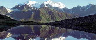
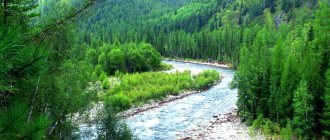
The side where Primorye is located is hilly and is part of the Sikhote-Alin mountain region. Average altitude indicators reach levels from 400–1000 m, and maximum values can reach up to 2000 meters. The flat areas are heavily swamped, cut by river valleys and covered with forest vegetation.
Hydrology of the region
The geographical region in Russia where Primorsky Krai is located is extremely rich in water resources. There are a large number of large rivers and lakes, many of which are of strategic importance.
The largest river in the region is the Ussuri, which carries water from the slopes of the Sikhote-Alin mountains. The Ussuri flows into the Amur River, which means it is strategically important for both the ecology and the economy of the region. It flows through the territory of the Primorsky and Khabarovsk territories, as well as through the territory of the Chinese province of Heilongjiang.
The river system received its modern name in 1972, when, after the conflict with the People's Republic of China, the region experienced a massive removal of Chinese names. Before that, the river was divided into several sections with different names: from the source to the village of Arkhipovka it was called Yanmutkhouza, then to the village of Verkhnyaya Breevka it was called Sandagou, and from Breevka to the confluence with the Daubikhe River it was called Ulakhe, and only after the merger was called Ussuri.
However, the border conflict forced the country's leadership to abandon most of the hydronyms and bring the entire river system to a common denominator under one name.
Climatic conditions
The coastal climate is moderate monsoon, the territory is dominated by humidity and strong winds, changing direction twice a year. In winter, the region is covered by the Asian High with little precipitation, severe frosts and minimal snow cover.
Northwest winds bring January temperatures down to –32 °C. Summer is characterized by high clouds, prolonged fog and heavy rains. The area receives up to 900 mm of precipitation per year. The first months are cool with temperatures up to 15 °C, more reminiscent of spring. The warmest is August with an average temperature of 20 °C. Primorye is where the strength of the south wind is twice as strong as the north. The best time of year here is autumn, and there are more clear days in winter than in summer.
Flora of Primorsky Krai
Most of the territory is occupied by low mountains with rounded peaks, called hills in this region. They are covered with mixed forests of the Ussuri taiga. This is one of the richest forested areas of the great country. This is a real jungle of the Northern Hemisphere, where multi-tiered taiga is the main reason for the evergreen taiga. Korean cedar, Mongolian oak, Manchurian walnut or Amur philodendron, eleutherococcus, lemongrass and ginseng. Primorye is mesmerizing with such views. Where else in Russia can one see such representatives of the plant world in the wild? Mushrooms and berries grow here, and the number of types of medicinal herbs growing in Primorye exceeds many other regions of the country.
Economy of the region
On the territory of the Primorsky Territory there are mineral deposits that are unique in their composition and size, which serve as the basis for a well-developed mining industry.
Tungsten, fluorspar, lead and tin are mined in the region. In addition, almost one hundred percent of the boron products mined in the country come from the Primorsky Territory (Russia), where the largest specialized plant in the country, Bor, is located. Most of the rare elements mined in Primorye are exported. Mainly to China.
Fauna of Primorye
The uniqueness of the fauna of the region lies in the amazing combination of representatives of the southern and northern regions. The main part of Russian bird species is located in the Primorsky Territory. Rare and endangered species, migratory and sedentary representatives, find a cozy corner in the region. Golden eagles, eagles, ducks, geese, herons and swans fly here.
The taiga is home to red deer, wild boars, elk, Himalayan bears, lynxes and leopards. The protected areas protect the forest cat, Nepalese marten, sable, otter and mink, Amur tiger, badger and red wolf. On the territory of the Ussuri taiga, 4 reserves have been created that protect and enhance the flora and fauna of the region.
Primorsky Krai
Vladivostok - the pulsating heart of Primorye
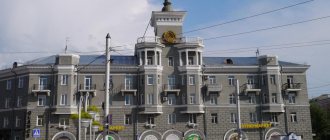
How to characterize this city? Over the course of 158 years, it was able to grow from a military post into a modern, developing city with a rich history and interesting appearance. You need to start getting acquainted with Primorye, of course, from the dynamically developing capital of the region, which is located 9,000 kilometers from Moscow. People can get here both by air and by sea - by plane, train or sea ferry.
Urban architecture
In the city you can find more than 600 amazing historical monuments, as well as architectural structures built more than a hundred years ago.
Cultural heritage of the city
Vladivostok can rightfully be called the cultural capital of the Far East - there really is something to see here.
People come here to visit theaters, see the collections of museums and art galleries, and visit the Philharmonic. The best place where you can take a fascinating dive into the history of the region is the Primorsky State United Museum named after. V. K. Arsenyeva . Stone sculptures from the burial complex of the Jurchen prince Esikui, dating back to the 12th century, are exhibited here.
Here you can see magnificent items made of ancient porcelain, earthenware, glass, animal figures carved from bone by the inhabitants of the Bering Sea coast, as well as weapons of Russian, Chinese, Japanese, Indo-Chinese and English warriors dating back to the 17th century.
Where are the attractions located?
The main attractions worth seeing are concentrated within the center along the coastline. The historical center of the city is located along the northern coast of the Golden Horn Bay several blocks inland. You can feel the closeness of Asia in the old quarters that were built by the Japanese and Chinese.
Places that are already loved by tourists: Cape Tobizin , Shkota Island and Cape Akhlestyshev - here are ideal conditions for surfing. It is also worth taking a ride on the funicular and visiting the extreme point of the mainland - at the Tokarevsky lighthouse .
Beaches of Vladivostok
The most accessible place for summer recreation in the city is the Kungasny beach , located in the area of the cape of the same name. Not long ago it was ennobled and transformed by removing the kebab tents and laying asphalt. To attract tourists, an art object has been installed here - a heart in a vest with the inscription “Vladivostok”.
There are only two such places in the world - in Vladivostok and California. The glass cove looks like a kaleidoscope or a scattering of small candies, especially on a bright and sunny day. Once upon a time, a large amount of glass bottles and waste from a porcelain factory ended up in the sea in this place. Today there is an atmosphere of comfort here: the bay is framed by low cliffs, along the edges there is a stone platform made of volcanic lava. You can camp on the beach with a car or a tent.
The recreation area at Cape Tokarevsky, where one of the oldest lighthouses of Primorye is located - Egersheld, is divided into paid ones - there is quite a comfortable infrastructure - there are tables and benches, awnings, cozy gazebos. And the free one - there is a rocky bottom, the beach itself is more like a viewing platform, from where it is good to look at the sea and sunsets - this is what the townspeople come here for.
The most popular beach spot among city residents is Shamora , or Lazurnaya Bay, sung by the Mumiy Troll group. There is a convenient infrastructure for summer holidays. The coastline of Shamora is conventionally divided into three beaches.
In the suburbs of Vladivostok there is a recreation area “Laguna” , which city residents love for its comfort. To visit the beach you will have to purchase an inexpensive day pass, which will give you the right to use beach services. Swimming is allowed here; the shore and bottom of the beach are sandy.
Young people relax in the Nakhodka urban district; the beaches of Livadia and the seaside “Bali” - a bay with turquoise water and fine sand - Triozerye .
City bridges
Vladivostok is also a real “city of bridges”. This name is firmly attached to the city. Here you can take a photo for memory against the backdrop of several bridges. The most photogenic of them is the Golden Bridge - it connects two parts of the city, but the most recognizable one is in the wallet of almost every Russian - this is, of course, the Russian Bridge , it is depicted on the 2,000 ruble banknote.
Russky Island
You can cross the Russian Bridge to the Russky Island . The island is famous for its breathtaking views from Cape Tobizin, beaches and the remains of numerous fortifications of a military fortress. 100 years ago, Vladivostok was one of the most technologically advanced and impregnable military fortresses in the world; you can verify this by visiting the Voroshilov Battery Museum and the restored Novosiltsevskaya Battery with a breathtaking sea view.
Primorsky Oceanarium
Also on Russky Island there is a federal university campus, which has very well-groomed grounds and a pleasant embankment.
There is also a lot of entertainment here, among which we can highlight the aquarium, which was built relatively recently. This is a huge building that looks like a huge bivalve shell. Of course, children will be interested here, because, having forgotten about time, they will be able to look at sea lions and seals, powerful stingrays, sharks, and frolicking beluga whales swimming overhead. The dolphinarium, which has a pool-arena and stands for 800 spectators, hosts performances with dolphins, beluga whales and other sea animals.
We also recommend checking out the beaches of the island. The most convenient beach to visit is the beach on the FEFU campus. You just need to go down to the sea. A 20-minute walk from the aquarium is the sandy Paradize beach with kebab bars and places for picnics, tents and long-term parking. Ajax Beach, closest to the entrance to the island, is often crowded.
Immersion in the untouched nature of the Khasan region
An equally popular place among guests of the region is the Khasansky district, where the picturesque Far Eastern Marine Biosphere Reserve . Here you can bask on the beaches with golden sand and get a boost of energy and happiness for the year ahead, staying at one of the comfortable recreation centers.
And again there is wild nature around! On a boat trip, travelers will be able to see the Far Eastern seal, picturesque rocky cliffs and swim in blue water.
For fans of hiking - Sikhote-Alin Nature Reserve
The Sikhote-Alin Nature Reserve is the largest among the nature reserves of the Primorsky Territory, its area is more than 400 thousand hectares. This unique territory is included in the UNESCO World Heritage List.
Here, city residents, accustomed to smog, exhaust and smoke from processing plants, will be able to breathe in crystal clear air and explore the amazing nature - after all, the reserve is located within the range of the Amur tiger. The most extensive and long-term scientific research on this predator is being conducted here. Not only the tiger can be found in the territory of this natural park, there are also brown and Himalayan bears, American mink, wild boar, roe deer and Far Eastern forest cat.
The reserve is also a reserve for a large number of rare and endangered plants. Almost the entire territory is covered with cedar, fir-spruce and oak-birch forests. Only in this part of mainland Russia can you find the rarest plants - rhododendron Faury and primrose jeza.
Historical reference
The first settlements on the site date back to the Paleolithic era. Tribes of hunters and fishermen settled here. Primorye is the birthplace of the medieval states of Parhe, Jin and Liao.
Among the list of Russian regions by area, modern Primorsky Krai is in 22nd place. But about 100 years ago, the territory of the modern region was designated as the South Ussuri region, which was poorly studied and sparsely populated. Migration flows to the Far Eastern expanses were influenced by the abolition of serfdom in 1861 and the construction of the Trans-Siberian Railway and the Ussuri Railway. In search of free and fertile lands, former serfs and retired Cossacks became the main segment of the population of modern Primorye. The international importance of Vladivostok has grown as a major Pacific port of Russia and the largest populated area in the region.
In the 30s of the 20th century, there was a demographic “cleansing” in Primorye. Representatives of Chinese and Korean nationality were forcibly evicted from here. In wartime, the region fell on the shoulders of the fate of the industrial supplier and agricultural breadwinner of the Motherland. The official date of formation of Primorye is considered to be October 20, 1938, when the huge Far Eastern region was divided into Primorsky and Khabarovsk.
Geography
Primorsky Krai, which is part of a geographical area called Primorye, has extremely diverse climate, landscape and wildlife. However, with all the diversity of the natural environment, the region occupies less than one percent of the entire territory of Russia, occupying twenty-third place in terms of area among other subjects of the federation.
The maximum length of the region from north to south is about nine hundred kilometers, and the width from west to east is no more than three hundred kilometers. Moreover, the northernmost point is located at the source of the Dagda River, the southernmost point is at the mouth of the Tumannaya River. The western point is not precisely localized, since it is tied to the source of the small active river Novgorodovka. At the same time, the easternmost point has been determined with maximum accuracy - this is the tip of Cape Zolotoy.
Population of the region
The remoteness from the Central regions and the proximity to foreign countries influenced the diversity of the national composition of the population in Primorye, where this is recorded in the statistical data of the region. In terms of population, the territory is dominated by 11 nationalities. The troika is led by Russians; about 2 million people live in their territory. Silver belongs to representatives of the Ukrainian diaspora - more than 90 thousand people, and bronze belongs to Koreans - there are 17 thousand people. In addition to these representatives, Tatars, Belarusians, Chinese, Chuvash and other nationalities live in the territory where Primorye of the Far East is located.
At the end of the 20th century, immigration flows poured into the territory of the region from neighboring and nearby states. Today on the streets of Vladivostok, Nakhodka or Ussuriysk you can meet representatives of China, Vietnam or North Korea. The main occupations for immigrants from these countries were construction, trade and study.
The average life expectancy for women is much higher than for men and is 71.7 years, and for the stronger half - 59.8 years. The region's population is rapidly aging, which leads to a process of depopulation.
The working population is 70.1%, and the unemployment rate reaches 6%. According to 2022 statistics, out of 1,923,116 people living in the region, 921,063 are male, and 1,002,053 are female. Most of the population lives in cities and amounts to about 1,500,000 people. A third of the population lives in rural areas.
Flora and fauna of the region
The Primorsky Krai of Russia is home to numerous species of animals, birds and insects, many of which are listed in the Red Book or are endemic to the region.
Of course, the most famous representatives of the Red Book fauna are the Amur tiger and the Far Eastern leopard, which are under threat of extinction. Not only the country's authorities, but also numerous international organizations involved in the conservation of rare species are concerned about the conservation of these two cat species.
The reduction in the number of animals in the region of the Russian Federation, where Primorsky Krai is located, is closely related to human activity, which is actively developing the rich resources of the Far East. The first to suffer are the rivers, from which China actively withdraws water for industrial enterprises and dumps poorly treated industrial waste into water bodies.
In addition, desertification has begun in the border areas of China, which is now affecting the territory of Russia. The area of coniferous-deciduous forests, where rare species of animals and birds live, has begun to decline significantly. Photos of the Primorsky Territory, where there are numerous natural sites, picturesque landscapes and nature reserves, are very popular among travelers and nature lovers.
How to get to Primorye?
To get to the region of the Far Eastern hills, a tourist from Moscow to Vladivostok will have to travel 9259 km by rail and spend more than 6 days on the trip. Of course, such a long distance is covered by a branded train with comfortable conditions for passengers. You can speed up your travel time by taking a plane flight from the capital, spending a little more than 8 hours of flight time.
From St. Petersburg it is also easy to get to Primorye. Where this can be seen from the flight schedule in this direction. Direct flights are operated by Ural Airlines, and with a transfer in Moscow or Novosibirsk they are carried out.
Tourist opportunities
Despite such a huge remoteness, Primorye does not require an advertising description. Its famous riches of the Ussuri taiga are unique and immense. This is a treasure trove for hunting enthusiasts. The routes cover a variety of lands, and there are also extreme trails.
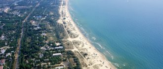
The beauty of the sea coast of the region is simply mesmerizing - it has sandy beaches, rugged shores, numerous bays and wide bays. Tourists are attracted to the emerald islands, ports, protected areas and recreation centers.